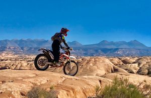
 A lot of information is being shared about the Travel Management Plan (TMP) in Labyrinth Rims/Gemini Bridges area North West of Moab on social media right now. It’s great to see so much energy and enthusiasm around this issue for an area that so many of us know and enjoy. As motorized recreationists, it is imperative that we make our voices heard in the most reasonable and informed way possible.
With that in mind, we wanted to provide you with an update regarding the current phase of the travel management planning in this area of Moab. We are in the scoping process which is the first step in travel management planning, this is when the Bureau of Land Management (BLM) seeks to identify public concerns and issues to be analyzed.
This issue is not new – Ride with Respect (RwR), The Trails Preservation Alliance (TPA), and the Colorado Off Highway Vehicle Coalition (COHVCO) have been engaged in this process both financially and legally for more than 4 years. We have been working diligently providing comments for the previous reviewed TMA’s and will continue to do so as this process moves forward to provide a voice for all motorized recreationists.
Background
This process is the result of a lawsuit filed on behalf of the Southern Utah Wilderness Alliance (SUWA) claiming the BLM failed to follow the correct process in 2008 when developing its Travel Management Plan (TMP) across much of southern Utah. SUWA settled and as part of the 2017 settlement agreement the BLM is now revisiting a number of Travel Management Areas (TMA) across the state of which Labyrinth is the third of 12 total TMA’s. See the map of these TMA’s which are all located in the dark gray highlighted areas in the Southeast portion of UT. (Note: The other TMA’s located on this map, predominantly in the NW part of the state, are not part of the SUWA settlement but will be undergoing the same process.)
The first revisited TMA was the San Rafael Desert, the area across the Green River from Labyrinth Rims/ Gemini Bridges TMA. The San Rafael Desert final TMP decision was viewed as acceptable for motorized recreationists in that it kept two-thirds of the existing routes open, most of which SUWA set out to close. The second, the San Rafael Swell, which includes trails such as the infamous 5 miles of Hell, Colored Trails, Waterfall, and Devil’s Racetrack is also underway with the scoping phase that ended in early March 2021.
The Future
With 9 more TMA’s undergoing the same process in the coming months we hope to see the same enthusiasm for the previous ones. The other TMA’s are not as well known as the Labyrinth/Gemini zone but they all contain valuable motorized routes. As more people find value in outdoor recreation (camping, hiking, cycling) it’s important to protect these routes for everyone’s use. Groups such as RwR, TPA, COHVCO, and others such as Colorado Off Road Enterprise (CORE) have been and will continue to be engaged for all recreationists that utilize motorized routes.
What we would like to ask of you is that you stay focused on the process and the steps that will be effective in achieving a good outcome. Make respectful, thoughtful comments pointing out what you care about is valuable, raising factual concerns about the maps, pointing out linkages and uses that might be missed, and so on. Disrespectful or unprofessional comments are as likely to hurt as to help. If you wish to help by making comments, the list below contains important topics to mention.
Advocating for Motorized Use
- Designated routes for motorized use are a small portion of public land.
- There are millions of acres designated as wilderness or for other non-motorized use.
- OHV use contributes millions of dollars annually to the economy.
- Substantial volunteer hours are contributed by the OHV community.
- Public land is for everyone, motorized and non-motorized recreationists have a right to enjoy whatever recreation they prefer.
- Access to camping areas affects all outdoor recreation and is not just a motorized user issue.
- Mention areas on maps, routes, campsites, or connections that might not exist on current maps.
To make comments go to the BLM website.
Click the green box on the left that says “Participate Now” and then click on the green box on the right that says “Participate Now”. Follow the submission process from there. Submissions are open until 11:59 PM Monday April 26th.