BLM Monticello Field Office
ATTN: Monument Planning
365 North Main
Monticello, UT 84535
RE: Bears Ears Monument Planning Assessment
Dear Planning Team:
The above Organizations are submitting these comments to provide our concerns around the lack of information on issues critical to the development of public comment and clearly state without this information provided, substantive public input is difficult to provide. It is our position that the current Assessment document is often internally conflicting on standards to be applied and is often vague on basic information that will be highly relevant in these early stages of the Planning Process. An example of the basic information would be the status of the Forest Plan Revision efforts currently underway on the Manti-LaSal NF as a result of the Proclamation and combined planning effort. The lack of foundational information such as this is a major barrier to detailed public comment and analysis.
Any substantive review of our concerns around proposals is precluded without this information. While we might be able to support Alternative C of the Proposal simply due to the fact it provides a range of alternatives for the Proposal area rather than managing the entire area under a single ROS standard, even this Alternative has foundational issues and direct conflict with many legal requirements for planning, forcing us to object to even this Alternative. The motorized community has strong opposition to Alternative D of the Proposal based on our experiences with planning efforts throughout the region as single intensity recreational opportunities simply never work and create a HUGE amount of conflict. The arbitrary nature of Alternative D is also a basis for opposition, as we are unable to understand how a single standard ROS was thought to be needed or appropriate. This decision is simply never discussed in the Proposal.
This position has been developed as a result of our involvement in the development of hundreds of Resource Management Plans (“RMP”) throughout the Western United States. In addition to this experience, we have participated in a wide range of national rulemaking and management efforts. Our desire is to provide high quality information for decision making early in the process in the hope of avoiding many of the pitfalls we have encountered in planning efforts throughout the region. This information is also provided as the Proposal Planning area has provided exceptional recreational opportunities for the public for decades without a large amount of controversy. These opportunities have drawn users from Colorado, Utah, Wyoming and numerous other states and Canadian provinces.
1. Who we are.
Prior to addressing the specific concerns of the Organizations regarding the Proposal, we believe a brief summary of each Organization is needed. The Off-Road Business Association (“ORBA”) is a national not-for-profit trade association of motorized off-road related businesses formed to promote and preserve off-road recreation in an environmentally responsible manner. One Voice is a non-profit national association committed to promoting the rights of motorized enthusiasts and improving advocacy in keeping public and private lands open for responsible recreation through strong leadership, advocacy, and collaboration. One Voice provides a unified voice for motorized recreation through a national platform that represents the diverse off-highway vehicle (OHV) community. United Four-Wheel Drive Association (“U4WD”) is an international organization whose mission is to protect, promote, and provide 4×4 opportunities world-wide. The Colorado Off-Highway Vehicle Coalition (“COHVCO”) is a grassroots advocacy organization of approximately 2,500 members seeking to represent, assist, educate, and empower all OHV recreationists in the protection and promotion of off-highway motorized recreation throughout Colorado. COHVCO is an environmental organization that advocates and promotes the responsible use and conservation of our public lands and natural resources to preserve their aesthetic and recreational qualities for future generations. The Trail Preservation Alliance (“TPA”) is an advocacy organization created to be a viable partner to public lands managers, working with the United States Forest Service (USFS) and the Bureau of Land Management (BLM) to preserve the sport of motorized trail riding and multiple-use recreation. The TPA acts as an advocate for the sport and takes the necessary action to ensure that the USFS and BLM allocate a fair and equitable percentage of public lands access to diverse multiple-use trail recreational opportunities. Colorado Snowmobile Association (“CSA”) was founded in 1970 to unite winter motorized recreationists across the state to enjoy their passion. CSA has also become the voice of organized snowmobiling seeking to advance, promote and preserve the sport of snowmobiling through work with Federal and state land management agencies and local, state and federal legislators telling the truth about our sport. CORE is a motorized action group dedicated to keeping motorized trails open in Central Colorado and the region. Collectively, ORBA, U4Wd, One Voice, TPA, CORE, CSA and COHVCO will be referred to as “The Organizations” for purposes of these comments.
The Organizations are submitting these comments to supplement the input of local clubs and to assist the planners in developing a high-quality science-based management plan that continues to provide recreational opportunities in a high-quality manner. The Organizations submit that these opportunities will only become more valuable with the passage of time given the growing population of communities in and around the Monument. The Organizations are also very concerned with the ugly anti-recreation tone that is displayed in the Assessment and related documents. It has been our experience that recreation resources and cultural resources are not mutually exclusive but are often inseparable to achieving the goals of the Proclamation in the Planning area. Recognition of this relationship must be addressed early in the planning efforts.
2(a). Assessment of Bears Ears Monument concerns.
At the landscape level, the Assessment is problematic as often the Assessment lacks anything similar to a large-scale vision for the area, even in general terms, which would be critical information for the public in preparing substantive comments. The existence of problems such as this is concerning, as the Original Proclamation was issued by President Obama on December 28, 2016. [1] This planning area has been the subject of extensive press coverage as a result of the multiple Presidential Proclamations that have occurred and the numerous litigation efforts that have resulted as well. While there is much discussion around the small changes in these Proclamations, there is a large amount of consistency and alignment across all the Proclamations and this consistency in the Proclamations easily could have been the basis for vision and guidance in the assessments, and that has simply not been provided. Despite much of the area being designated for almost 5 years, there is no vision for the area provided in the Assessment. Given the passage of a significant length of time since the initial Proclamation, we are concerned that the Assessment does not reflect the current status of planning for the area. Is the vision for the monument area an entirely new Resource management plan, a limited scale resource plan amendment, a resource plan with complete travel plan, a resource plan with site specific travel analysis? This is just basic information that the public should be provided for any assessment of the management situation.
The lack of clarity in the Assessment on basic issues is highlighted further by the complete lack of information on how this effort aligns with the current revision of the Manti-LaSal NF Resource Plan. Basic questions such as how previously submitted comments in the Forest Plan Revision will be handled in the management of the Monument, simply are never even raised as an issue. This is basic information that the assessment should be providing basic guidance on.
The Assessment fails to address basic information on issues that have plagued cross jurisdiction planning between the USFS and BLM for extended periods of time. Often basic conflicts on designations are difficult to align. As an example of these types of programmatic problems would be failing to address how will designations similar to the ACEC concept be applied on USFS lands? Is there even a desire to align these types of concepts?
The Assessment further fails to provide any insight into how boundary issues will be resolved between the Bears Ears Monument and National Recreation Areas that are adjacent to a large portion of the planning area. This type of guidance will be critically necessary for any routes that may cross back and forth between the boundary line given the different management standards for each area. Glen Canyon NRA was Congressionally designated in 1972 with the following purpose:
“to provide for the public outdoor recreation use and enjoyment of Lake Powell and lands adjacent thereto in the states of Arizona and Utah and to preserve the scenic, scientific, and historic features contributing to the public enjoyment of the area.” [2]
Natural Bridges Monument is also surrounded by the Bears Ears Monument, and a basic vision of how the competing visions and plans identified in each Proclamation will be aligned. The following fundamental resources and values have been identified for Natural Bridges National Monument:
- The three natural bridges—Sipapu, Kachina, and Owachomo. Natural Bridges National Monument is the one place where three natural bridges (stream carved features) are found in close proximity. Sipapu, Kachina, and Owachomo exemplify natural geologic and hydrologic processes that form and modify natural bridges over great spans of time
- Cultural resources. The entire monument has been listed on the National Register of Historic Places as the Natural Bridges Archeological District, which includes 507 contributing resources. These resources contribute to the broader knowledge of the full range of prehistoric occupation on Cedar Mesa and include both simple lithic scatters as well as multi-room pueblos with stratified deposits.
- The remote and undeveloped setting. Natural Bridges National Monument exists away from significant development, allowing for night skies, soundscapes, and air quality to be maintained in their natural condition.
- Moist canyon habitats. Protected natural hydrologic processes, geomorphic processes, and biotic processes are necessary for maintaining the natural condition of canyon habitats and associated biotic assemblage. [3]
This alignment will be a critical issue for boundary areas, given the Glen Canyon NRA is Congressionally designated but the Bears Ears Monument is only created via a Presidential Proclamation. Protecting the values of the NRA must be weighted higher given the Congressional designation rather than a mere Presidential Proclamation, as the primacy of Congressional authority to manage land is identified in the Constitution [4]. No insight has been provided in this assessment on possible resolution of these conflicts. Once foundational legal questions such as this are resolved, additional questions such as alignment of existing monuments with the Bears Ears Monument must be addressed as well. Given that these issues have been present since the original proclamation was issued almost 5 years ago, the Organizations are frustrated that no information on issues such as this has been provided in the Assessment.
2b. Guidance to date has been inaccurate on the Biden Proclamation and must be avoided moving forward.
The value of these general statements of vision for the Proposal area cannot be overstated as this type of vision can avoid decisions that are in direct conflict with existing decisions, proclamations and law. It is unfortunate that we must start our comments in addressing a landscape level conflict of basic management and state that these types of conflicts are unnecessary and must be avoided moving forward. While the Organizations are aware that many recreational activities were addressed in the Proclamation as important but not protected by the Proclamation, the Organizations are also aware that analysis of this issue does not merely stop as a result. Often times while the particular recreational activity may not have been elevated for protection, the resources relied upon for the activity is addressed with a high degree of detail in the Proclamation. How this issue will be resolved is worthy of inclusion in the Assessment and public comment early in the NEPA process.
This type of basic conflict is neither abstract or remote but has already happened as exhibited by the direct conflict of existing guidance for the area and the Biden Proclamation on the issue of roads and trails. On December 16, 2021, BLM Utah State Director issued a guidance memo on Interim management of the Monument (hereinafter referred to as the “Guidance memo”) which provides far more general guidance on the management of the area than is provided in the Assessment. [5] This is problematic as the public should not have to search out documents providing basic vision in the manner that has been pursued by managers to date. The value of a planning assessment is the fact that the Assessment serves as a one stop shop for resources in the planning effort. That has not been achieved here.
While more Guidance on basic visions for the Monument in provided in the Guidance memo, the type of conflict between Proclamations, statutes and case law the Organizations we are concerned about are immediately found to be present in the Guidance memo. As an example, the Guidance memo provides as follows:
“Proclamation 10285 makes clear that while the monument area is replete with diverse opportunities for recreation, including “rock climbing, hunting, hiking, backpacking, canyoneering, whitewater rafting, mountain biking, and horseback riding,” that support the travel and tourism sector of the local economy, those activities are not themselves objects of historic and scientific interest designated for protection. Therefore, the agency must ensure that any proposed recreation use or activity is evaluated for monument management plan or resource management plan conformance and consistency with the proclamation prior to being authorized.” [6]
Any analysis of how this decision was made is never discussed it the Guidance memo and is also completely avoided in the Assessment. This avoidance occurs despite the fact that roads and trails, resources synonymous with those actions are discussed in great detail as cultural resources for protection in the Biden Proclamation.
As an example, Chacoan Roads, are specifically addressed 4 different times in the Proclamation and these routes have significant cultural value. The cultural and historic value of these routes has been recognized by the National Parks Service [7] and Grand Canyon Trust [8] and clearly building understanding of the unique nature of these routes may require routes for access to the protected areas, as Chacoan Routes may travel some distances. The Hole in the Rock Trail is directly referenced in the Biden Proclamation 3 times, and 2 more times in previous Proclamations but no vision for this resource is provided in the Assessment despite the Hole in the Rock Trail spanning across the southern portion of the Monument area and being protected on the National Register of Historic Places since 1982. Despite this recognition we are unable to find any even large-scale vision for these areas or resources.
Even if these resources are managed for their cultural and historic nature, and access to these specific routes and access routes is intended to be educational in nature, they have recreational characteristics as well. Despite recognition of these resources almost a dozen times in the various proclamations, no guidance or analysis is provided in the Assessment. This is the type of broad landscape problem that an Assessment should be addressing. While the Organizations do not contest the statement that many non-motorized recreational activities are not protected, the Organizations vigorously assert that roads and trails are a foundational characteristic to be protected in the Proclamation. We would encourage planners to broadly interpret the scope of the Proclamation to address not only the specific words provided but also the specific resources and values that are identified.
2(c) The Monument area has a host of other designations must be addressed many of which will have recreational value to be protected.
Again, the Organizations are concerned that the blanket summary of the Proclamation provided in the Guidance materials is simply inaccurate and overly focused on only a small portion of the Proclamation while ignoring other portions of the Proclamation. The Assessment also appears to be trending in an overly focused vision for the Monument, while ignoring the previous protections that have been placed on the usage or resource in the area. In this climate, the Organizations are unwilling to assume these resources are going to be managed in the historical manner. The Assessment must be addressing these competing goals and objectives for the area as this balance will be critical in the planning process. After reading the entire Assessment, we are unable to determine how many sites have been managed for other priorities that would not be impacted by the Proclamation. This again is a significant problem as we are unable to understand how the scope of work was developed for the Assessment and how these competing values will be resolved.
This overly narrow scope of the Assessment and Guidance materials fails to address critical resources in the area that have been previously protected, such as the Hole in the Rock Trail. While we are only addressing the Hole in the Rock Trail, this is an example of our concerns and should in no way diminish the value of the other locations that have not been addressed in these comments. The Hole in the Rock Trail has been on the National Register of Historic Places since 1982.[9] This is astonishing given that the Hole in the Rock Trail is mentioned in the Proclamation 3 times but the Assessment never references the fact this is also on the National Register. The Hole in the Rock trail was identified in 1982 and approved for listing on the National Register of Historic Places as follows:
“The Hole-in-the-Rock Trail between Escalante and Bluff is approximately 180 miles long and for the purposes of the National Register nomination/ the boundary lines are two hundred feet on either side of the trail designation on the attached USGS maps.
The application for listing on the National Register for the Hole in the Rock Trail almost mirrors portion of the Proclamation. The application for listing of the trail covers more than 145 pages and is supported by 31 different people or parties. Hole in the Rock Trail is also specifically addressed in the Proclamation three different times as exemplified as follows:
“The Bears Ears region is also important to, and shows recent evidence of, non-Native migrants to the area. From the smoothed-over surfaces of the Hole-in-the-Rock Trail to the historic cattle-ranching cabins, and the convoluted series of passages and hideouts used by men like Butch Cassidy, the Sundance Kid, and other members of the Wild Bunch….” [10]
The Proclamation continues discussion of this resource in a manner that aligns with the National Register listing as follows:
“Nearby San Juan Hill was the last major obstacle for the Hole-in-the-Rock expedition and presents visible evidence of the weary expedition’s effort to cross Comb Ridge, including parts of a road, wagon ruts, and an inscription at the top of the ridge.” [11]
Proclamation continues its discussion of the Hole in the Rock Trail as follows:
“The area’s unforgiving topography, composed of expansive stretches of slickrock periodically interrupted by deep canyons, challenged Latter-day Saint settlers that traveled along the Hole-in-the-Rock Trail and left wheel ruts and other traces of pioneer life.” [12]
In addition to the recognition of the trail on the National Register of Historic Places, the National Park Service has a mile-by-mile summary of the Route and identifies it as follows:
Much of Hole-in-the-Rock Road is passable to high-clearance, two-wheel drive vehicles in dry weather. [13]
The NPS materials provides following pictures as an example of the Hole in the Rock trail:
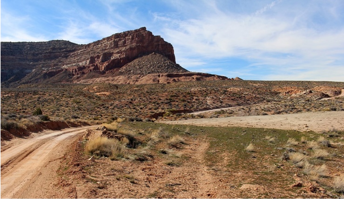
Not only is the Hole in the Rock Trail on the National Register of Historic Places and mentioned in the Biden Proclamation repeatedly it is a global recreational destination for a wide range of uses. The following pictures represent the broad range of recreational opportunities that are provided as the public follows the route taken by pioneers.

This recreational activity on the Trail provides the public with great appreciation for the struggles that the pioneers that created the trail faced as they traversed these areas with only a horse and buggy or on foot with limited resources. Given the repeated recognition of routes and resources that have already been protected for their values that align with the Proclamation, the Organizations are concerned that the current Assessment and previous guidance documents provide an overly grim picture for recreational activity on the Monument, and as a result have greatly limited the public ability to provide meaningful comment on the Proposal. Again, we are concerned with the dismissal of the assessment of recreational concerns in the assessment without recognition of the relationship of recreation in educating the public regarding the historical activities that have occurred in the area. This lack of recognition results from the failure of managers to separate activities from the resources that are being protected.
2(d)(1) President Biden’s Executive Order 14008 must also be addressed.
Our concerns around the sufficiency of the Assessment span outside the application of Proclamations that are directly addressing the Proposal Area but are also addressing concepts and resources more generally. The recent issuance of Executive Order # 14008 by President Biden on January 27, 2021 would be an example of a decision that is only partially summarized in most materials we are seeing submitted in public processes, as the “30 by 30” concept is memorialized in this Order. It is our position that the 30 by 30 concept was long ago satisfied on the Monument planning area as almost everywhere in central and eastern Utah is either Congressionally designated Wilderness, Congressionally designated National Recreation Area, part of either the Bears Ears or Grand Staircase National monuments, Canyonlands National Park or some type of Roadless area designation. After reviewing the Proclamation 14008 and 30×30 concept more generally, we are unable to identify any requirement in these documents that Protection is only satisfied by Wilderness designations. Despite the lack of support for this standard, many are continuing to assert 30×30 is only satisfied with Wilderness designations.
In direct contrast to the summaries of EO 14008 we are seeing, this Order had provisions protecting lands generally but also had specific goals of improving access to public lands. The only Alternative that complies with these specific recreational access goals of improving access is Alternative D. §214 of EO 14008 clearly mandates improved recreational access to public lands through management as follows:
“It is the policy of my Administration to put a new generation of Americans to work conserving our public lands and waters. The Federal Government must protect America’s natural treasures, increase reforestation, improve access to recreation, and increase resilience to wildfires and storms, while creating well-paying union jobs for more Americans, including more opportunities for women and people of color in occupations where they are underrepresented.”
The clear and concise mandate of the EO to improve recreational access to public lands is again repeated in §215 of the EO as follows:
“The initiative shall aim to conserve and restore public lands and waters, bolster community resilience, increase reforestation, increase carbon sequestration in the agricultural sector, protect biodiversity, improve access to recreation, and address the changing climate.”
217 of EO 14008 also clearly requires improvement of economic contributions from recreation on public lands as follows:
“Plugging leaks in oil and gas wells and reclaiming abandoned mine land can create well-paying union jobs in coal, oil, and gas communities while restoring natural assets, revitalizing recreation economies, and curbing methane emissions.”
The Organizations are aware significant concern raised around the 30 by 30 concept that was also memorialized in EO 14008. While the EO does not define what “protected” means, the EO also provided clear and extensive guidance on other values to be balanced with.
2(d)(2). National Preservation Programs
The Organizations are also disappointed that the Proposal provides no guidance on how the numerous statutory requirements that are triggered by a National Monument Proclamation will be addressed. The Organizations are forced to make basic assumptions regarding the BLM management of the Area, such as that the monument will be managed as part of the National Landscape Conservation System within the BLM. These are questions we should not be making assumptions about.
Not only are these overlapping designations not recognized, there are numerous provisions that are highly relevant to the Proclamation and subsequent management efforts. Under the DOI, the National Park Service has a Congressionally mandated and dedicated program, with funding streams, for the development of educational resources in the management of Historic Resources and sites. This program is outlined as follows:
(k) EDUCATIONAL PROGRAM AND SERVICE.—The Secretary shall develop an educational program and service for the purpose of making available to the public information pertaining to American historic and archeologic sites, buildings, and properties of national significance. Reasonable charges may be made for the dissemination of any such information. [14]
NPS also has statutory authority to programmatically agree to manage other lands under DOI management. Given the large number of Parks in and around the planning area, alignment of these resources and programs probably makes a lot of sense. Basic questions such as this are again not addressed at all.
2(e). The Proposal must be outlining the vision for management of other recreational resources.
The relationship of EO 14008, the Biden Proclamation and the numerous globally significant routes in the area is exemplified as follows. The project documents could impact a huge number of these routes used near Moab and Canyonlands including several Jeep Safari Routes. The following list is just a sample of the huge number of routes in the planning area such as: The Arch Canyon Trail, Beef Basin, Lockhart Basin, Chicken Corners, the Catacomb Caves and the Catacomb Caves Spur trail. Many of these routes have huge recreational value but are often the only way to access historical and cultural resources in the areas, and these values are protected under the Biden Proclamation and Executive Order 14008.
The Organizations are disappointed that again the provisions of the Proposal that are addressing the overlap of these competing values is again blank 5 years after the original designation of the area.[15] The Organizations would propose that this planning effort be directed towards creating a list of these routes that are of the most concern for closure and . This list might include historical values of the trail; cultural values of the trail; educational materials that are available for the area; values that might be at risk and other criteria. This effort simply cannot be another inventory of Wilderness characteristics of the Area, as these are not mentioned in either EO. The Organizations would vigorously support this inventory of routes being a springboard to a management plan that was improving recreational activities and resources while protecting cultural values and wildlife habitat. The Utah OHV grant program and educational resources that could result from such a spring board could be immense and should not be overlooked. Similar efforts have been hugely successful in protecting resources and improving recreational opportunities as exemplified by the planning that has been hugely successful on routes such as the Rubicon Trail in California. Rather than being an anomaly of management this type of management effort is the norm on most places listed on the National Register of Historic Places, most national monuments
3. The Goals of the Congressionally mandated National Trails Strategy must be addressed.
The USFS has been developing the National Sustainable Trails Strategy for the last several years, [16] to comply with the mandate of the National Trails Stewardship Act of 2016.[17] While the BLM has not made any response to the 2016 Trail Stewardship Act, it remains applicable to BLM lands. The National Trails Strategy clearly identified goal of improving sustainable access and partnerships as a goal of this Congressionally mandated effort. This strategy also sought to strategically change how the USFS looks at partners and sustainability of routes and given the Proposal will guide the sustainable access and partnerships on the Forest for the foreseeable future. The Organizations are commenting on this issue given the fact this effort is simply never mentioned in the Proposal, despite the Congressional mandate. The National Strategy clearly states this as follows:
“Strategic Intent
The strategic intent of the strategy is to embrace and inspire a different way of thinking—and doing—to create sustainable change where grassroots initiative meets leader intent. The combined effort and momentum of many minds and hands will move the trails community, as a whole, toward shared solutions. This strategy builds on the many examples from across the country where the Forest Service, its partners, and the greater trails community have successfully embraced a community-driven and locally sustainable trail system model.”[18]
As we have noted throughout these comments the motorized community and local communities have worked hard to develop community driven locally sustainable trail systems on the monument for decades.
While the motorized community is far from perfect, the motorized community is the only community that brings significant resources to the Monument area to assist with management and maintenance of routes for the benefit of all users. In addition to the maintenance already provided, the Organizations are also aware that the Utah OHV Program has made significant strides in the development of their partner program. This program currently provides several million dollars for summer maintenance and this would be a program we would expect to significantly grow over the life of the RMP. This significant direct funding probably makes the motorized trail network the most sustainable on the Monument. These contributions were recently recognized by the USFS planners as part of the Sustainable Trails effort as follows:
“The engagement and efforts of motorized groups have improved the condition of trails across National Forest System lands and we look forward to continued engagement with the motorized community as part of the Trail Challenge…. During phase one, I welcome collaboration to adequately track, monitor, and acknowledge accomplishments by the motorized community while identifying lessons learned to incorporate into future phases of the Trail Challenge.”[19]
While many interests are struggling mightily to provide a single maintenance crew, the motorized community has partnered to provide dozens of well-equipped and trained crews throughout the state for decades providing winter route maintenance in partnership with local communities. Utah OHV Program has made HUGE strides in the last several years to create a similar maintenance program for summer recreational opportunities.[20] We believe this is a model of collaboration moving forward and the Proposal should avoid any unintended negative impacts to this collaboration and that over the life of the Proposal this partnership will grow into a hugely strong and important funding partner for the Monument managers.
In addition to the direct funding of USFS management, the sustainability of the motorized community is significantly buttressed by the fact that every route available for usage by the motorized community has been subjected to 50 years of scrutiny under the travel management Executive Orders issued by President Nixon in 1972. While these 50 years have often been challenging for everyone, it has also produced the most analyzed and sustainable trail network for any usage. No other recreational activity on the Forest has been subjected to this level of scrutiny and analysis.
4. Educational resources simply are not even discussed.
The Organizations are deeply troubled that 5 years after the original Proclamation from President Obama designating the area, the Assessments discussion of educational opportunities around the historical and cultural basis for the designation of the area as a National Monument is entirely blank. This is troubling as the Utah OHV program has greatly expanded funding and resources for educational issues in the motorized community over the last several years. Obviously aligning these two educational efforts would be a major step in a successful education effort for the entire area. Too often the Monument is seen as a replacement for a Wilderness designation in the area and as a tool to keep the public out of the area. Monuments are not Wilderness, and should never be managed as such and this could not be demonstrated better than the fact the Antiquities Act was passed more than 50 years before the Wilderness Act.
The Organizations vigorously assert that the failure of the public to understand the cultural and historic nature of the area has resulted in conflict around the management of the area for decades. Creating an education program that was addressing this lack of understanding would be a significant step towards management of the area. If an area has significance, it should be explained. The Organizations believe the Chacoan Roads in the area provide a perfect example of why education is necessary, as most of the public simply has no idea what these features even are.
The Organizations vigorously assert that access to these resources is a CRITICAL component of any educational program. The Hole in the Rock Trail, discussed elsewhere in these comments, provides a perfect example of how access to the area can improve educational effectiveness as this route remains an exceptionally challenging route for people to traverse with modern vehicles and modern resources, such as cell phones, OHVs and coolers. The difficulty of the journey on the route is exemplified by the fact that people traversed this same route with horses, buggies and often on foot without the ability to haul food and water is driven home. This is a FAR different and more effective educational experience than merely reading on a website that the route was difficult.
The Organizations are also aware that the hands-on nature of the experience can present a host of management issues, that can be resolved with quality educational materials. Often if the public is not aware of the value of the resource, this can lead to impacts. Once the public is educated about why the resource is valuable, they will avoid impacts to the resource. While managers frequently rely on programs like “Tread Lightly” to develop generalized materials for education, we are not sure this type of program is well suited to a Monument area as these materials do not reflect the unique historical nature of the areas. Given the unique nature of the area and resources, site specific materials simply will be more effective.
Given that 5 years has passed since the Original Proclamation, we would hope that a list of values or areas to be educated around would have been developed by this point. Based on the assessment, it appears that resource has not been developed and that is unfortunate as this type of site-specific resource will be a huge tool for the management of the monument, and educating the public about the historical significance of the monument area moving forward. Again, this type of material must be provided to allow for meaningful public comment to be provided.
5. Huge portions of the Proposal are pre-decisional.
The Organizations are very concerned that many decisions of the Proposal are highly pre-decisional, as exhibited by the closures of Wilderness Characteristics Areas to all motorized before there has even been any discussion of where these areas could be located. Given the decision to make these areas entirely non-motorized appears to have been made already, this would entirely defeat the purpose of NEPA. The fact that we are not even able to identify possible WCA designations or boundaries in the Assessment, the determination about the use of motorized vehicles in these areas could not be more pre-decisional.
The Organizations are also very concerned that in the Manti-LaSal RMP revision, more than 85,000 acres of additional roadless areas were created between the finalization of the 2001 USFS roadless Rule and the revision of the RMP. The Organizations have participated in a huge number of regional and national planning efforts with the USFS on a wide range of issues, ranging to well before the inventory and issuance of the 2001 Roadless Rule. As a result of this involvement on the 2001 Roadless Rule inventory process, we were surprised to see that the draft rule on the Manti/LaSal added more than 85,000 acres of Roadless Areas on the forest. According to the inventory of the 2001 Roadless Rule, the Manti/LaSal was finally determined to have 601,159 acres of Roadless Areas.[21] By comparison, the Draft RMP identifies the current Roadless Area inventory encompassing 686,780 acres, or an 85,621 acre or a 14% increase in Roadless Areas on the Manti/LaSal. [22]
While almost every Roadless Area had a significant change in designated acreage between the 2001 final Roadless Rule and the Draft RMP, changes were not consistent in size or application. The changes that have transpired between the 2001 Roadless Rule and Draft 2020 Revision are significant when certain Roadless Areas are reviewed such as the Dark/Woodenshoe Canyon Roadless area which changed from 14,551 acres in 2001 to 59,392 acres in the draft RMP or grew to more than 4 times its original size. While the Organizations are more than familiar with de minimis changes to boundary areas as a result of mapping technology improvements or ministerial errors, these levels of changes are not the result of issues such as this. The Organizations are not immediately opposed to Roadless Areas designations, as we support the more dispersed recreational opportunities that are protected under the multiple use management requirements of the Roadless Rule. We welcome the fact trails can be built and maintained in these areas, even though roads in these areas can only be maintained.
The Organizations believe a brief summary of the standards that are applied by Courts reviewing agency NEPA analysis is relevant to this discussion as the Courts have consistently directly applied the NEPA regulations to Proposals, and immediately create problematic reviews for analysis that decides management standards before even boundaries have even been proposed. Relevant court rulings have concluded:
“an EIS serves two functions. First, it ensures that agencies take a hard look at the environmental effects of proposed projects. Second, it ensures that relevant information regarding proposed projects is available to members of the public so that they may play a role in the decision making process. Robertson, 490 U.S. at 349, 109 S.Ct. at 1845. For an EIS to serve these functions, it is essential that the EIS not be based on misleading economic assumptions.”[23]
Other courts have summarized this standard as follows:
“[E]nsure that federal agencies have sufficiently detailed information to decide whether to proceed with an action in light of potential environmental consequences, and [to] provide the public with information on the environmental impact of a proposed action and encourage public participation in the development of that information.” [24]
As previously addressed in these comments, public involvement simply has not been stimulated and a hard look has not been performed when no information is provided in planning documents. The high levels of frustration expressed from the public in response to the release of the Proposal speaks volumes to the quality of information provided and the ability of the public to comment on the information. Rather than provide high quality information on the decision-making process, managers have failed to provide consistent information to the public regarding a general vision for the area. The Organizations simply cannot envision any resolution of this type of challenge in court to the agency plan that might be in favor of the agency.
Previously in these comments the Organizations addressed the complete lack of basic vision for the area provided in the assessment despite the original proclamation being issued more than 5 years ago. This problem has created a specific violation of NEPA requirements as the public has not been provided detailed high-quality information about the Proposal to comment upon. Rather information critical to commenting on the Proposal has been very slow to be provided and highly generalized in nature. Courts have specifically addressed the delayed release of information in this manner as follows:
“Of course, all of these Section 102 duties are qualified by the phrase “to the fullest extent possible.” We must stress as forcefully as possible that this language does not provide an escape hatch for footdragging agencies; it does not make NEPA’s procedural requirements somehow “discretionary.” Congress did not intend the Act to be such a paper tiger. Indeed, the requirement of environmental consideration “to the fullest extent possible” sets a high standard for the agencies, a standard which must be rigorously enforced by the reviewing courts.” [25]
There can be no argument that the hugely delayed release of supporting information for the Proposal would be the result of the agency foot-dragging that has previously been found to be a violation of NEPA requirements. For this reason alone, the Proposal should be returned to the agency for a full review of data for basic consistency and then released for public comment as the public is simply unable to understand what the proposal even is.
6(a). The Proclamation has had significant impacts on any assertion of areas being untrammeled by man.
The Organizations are intimately familiar with the explosion of discussions around Wilderness[26] and Wilderness management that occurs anytime large-scale planning is undertaken. The Organizations are aware that numerous statewide inventory efforts have been undertaken by the BLM in response to the Congressional requirements in the Wilderness Act. BLM lands in Utah are some of the most inventoried and reviewed lands in the Country for Wilderness, as most states have only been reviewed twice at the state level, while Utah has been reviewed three times. The most recent occurred in the late 1990’s and addressed many of the same areas as were previously reviewed by the BLM in 1980. It is significant to note that while many of these areas have reviewed multiple times for Wilderness characteristics, only a small portion of these areas have been managed for these characteristics.
As an example, the 2008 Monticello FO RMP managed 88,871 acres as WCA. Under Alternative E of the draft Plan up to 582,360 acres could have been managed as WCAs, which was summarized in the following chart:[27]
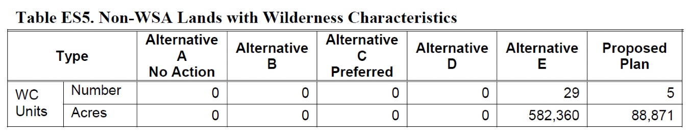
Why areas were not designated as Wilderness Characteristics areas under Alternative E remains important today. Given the large levels of increase for all activities that have been a management concern for planners since the late 1990s, the Organizations vigorously assert that any assertion that visitation or usage of any portion of the planning area has reduced since the late 1990s. We are unable to identify any portion of the Biden Proclamation that would provide a basis for a large scale expansion of Wilderness areas.
We expect the current Proposal to be no different in terms of the Wilderness discussions than a traditional RMP development, however this effort is also foundationally different from most other planning efforts in one critical manner when Wilderness is reviewed. In this matter we have a Presidential Proclamation that clearly states the entire area has been trammeled by man for up to 13,000 years. The Proclamation addresses more than a dozen areas and the transportation network that connects these areas and the long and often troubling history of the area, and clearly and repeatedly states the boundary is the minimum area to protect these resources. Given the Presidential recognition of these qualities, the Organizations submit that any assertion of large-scale areas being suitable and available for protection as Wilderness is going to face a harder factual battle than ever before. This cannot be overlooked.
The Biden proclamation also specifically required these characteristics and history to be protected for future generations by managers. While every NEPA action requires economic analysis, the overlap of the Proclamation and any proposed Wilderness areas presents a situation where increased costs of management and resource protection must be addressed in the economic analysis. This is a unique situation.
6(b)(1). Federal law mandates that there are no buffer areas for existing designations.
The Organizations are aware that many areas proposed for possible designation as Wilderness in various citizen Proposals are immediately adjacent to existing designations. This creates a situation where designation is being proposed in an effort to protect the Wilderness areas from outside usages. With all too high a level of consistency, these citizens Proposals are moved forward without addressing the fact that the 1984 Utah Wilderness Act specifically prohibited this type of buffer of Wilderness Areas as follows:
“PROHIBITION ON BUFFER ZONES
SEC. 303. Congress does not intend that designation of wilderness areas in the State of Utah lead to the creation of protective perimeters or buffer zones around any wilderness area. The fact that non wilderness activities or uses can be seen or heard from areas within the wilderness shall not, of itself, preclude such activities or uses up to the boundary of the wilderness area.”[28]
The Organizations vigorously oppose any designations that are seeking this type of buffer moving forward in the Planning effort, and are per se illegal. We are asking for this recognition as we do not seek any routes in Wilderness areas as this would be illegal and we ask for a similar barrier to illegal management standards be applied to all Proposals in the name of basic equality of parties in the effort.
6(b)(2) The Utah Wilderness Act provides a hard release of areas not designated as Wilderness.
The Organizations area also aware of the large areas of land that have been previously inventoried by land managers and found unsuitable for designation as Wilderness by Congress. An example of this would be provided in Alternative E of the RMP revision. The Organizations would hope that this planning effort does not end up being another discussion of why areas are not Wilderness, but rather is an effort that sets a vision and process for moving forward with the management and development of the planning area in a manner that conforms with the Proclamation. This decision not to designate these areas is also addressed with high levels of detail in the 1984 Utah Wilderness Act as follows:
“(3) areas in the State of Utah reviewed in such final environmental statement or referenced in subsection (d) and not designated wilderness upon enactment of this Act shall be managed for multiple use in accordance with land management plans pursuant to section 6 of the Forest and Rangeland Renewable Resources Planning Act of 1974, as amended by the National Forest Management Act of 1976: Provided, That such areas need not be managed for the purpose of protecting their suitability for wilderness designation prior to or during revision of the initial land management plan;”[29]
The Utah Wilderness Act further states this intent as follows:
“(b) The purposes of this Act are to… (2) insure that certain other national forest system lands in the State of Utah be available for non-wilderness multiple uses.”[30]
The Organizations are also all too familiar with the fact that areas that might be thought to possess Wilderness values are often managed by eliminating all usages that might be degrading those characteristics. As we have noted before this type of management is entirely pre-decisional, a violation of NEPA and is illegal under the Utah Wilderness Act and must be avoided.
6(c)(1) Wilderness recommendations should address the state efforts that have targeted these areas and designations.
In addition to the Legislative efforts regarding the planning area, the State of Utah has an exceptionally well-developed State Resource management plan along with a plan for every county in the state. [31] The State level resource plan clearly lays out the basic visions and goals for any Wilderness inventory in the state as follows:
“(j) the state’s support for any recommendations made under the statutory requirement to examine the wilderness option during the revision of land and resource management plans by the U.S. Forest Service will be withheld until it is clearly demonstrated that:
(i) the duly adopted transportation plans of the state and county or counties within the planning area are fully and completely incorporated into the baseline inventory of information from which plan provisions are derived;
(ii) valid state or local roads and rights-of-way are recognized and not impaired in any way by the recommendations;
(iii) the development of mineral resources by underground mining is not affected by the recommendations;
(iv) the need for additional administrative or public roads necessary for the full use of the various multiple-uses, including recreation, mineral exploration and development, forest health activities, and grazing operations is not unduly affected by the recommendations;
(v) analysis and full disclosure is made concerning the balance of multiple-use management in the proposed areas, and that the analysis compares the full benefit of multiple-use management to the recreational, forest health, and economic needs of the state and the counties to the benefits of the requirements of wilderness management; and
(vi) the conclusions of all studies related to the requirement to examine the wilderness option are submitted to the state for review and action by the Legislature and governor, and the results, in support of or in opposition to, are included in any planning documents or other proposals that are forwarded to the United States Congress;” [32]
Not only does the Utah State resource management plan lay out an express process for reviewing any possible Wilderness areas in an RMP, the State plan also provides general guidance for the inventory and management of these areas moving forward. These policies and guidelines are specifically outlined in the state report as follows:
– The State of Utah supports the continued management of Wilderness Areas as wilderness, in accordance with the Wilderness Act and when management provides for public enjoyment and active management under the Act.
– The State of Utah recognizes BLM Wilderness Study Areas recommended by the BLM during or before June, 1992, in accordance with FLPMA.
– The State of Utah opposes the recommendation of new Wilderness Study Areas subsequent to June, 1992.
– The State of Utah will actively participate in all public land management planning activities.
– The State of Utah opposes any legislation introduced in Congress to designate additional Wilderness Areas except for legislation introduced by a member of Utah’s congressional delegation.
– The State of Utah opposes any legislation introduced in Congress to designate additional Wilderness Areas unless such legislation is supported by the respective county commission or county council in the county impacted by the proposed legislation.
– The State of Utah will actively participate with federal partners in making wilderness management plans.
– The State of Utah opposes the management of non-wilderness federal lands as de facto wilderness, including “wildlands,” “lands with wilderness characteristics,” “wilderness inventory areas,” and other such administrative designations.
– The State of Utah opposes the review of additional U.S. Forest Service lands for wilderness, except for the reviews expressly provided for in the Utah Wilderness Act of 1984, §201(b).1
(a) secure for the people of Utah, present and future generations, as well as for visitors to Utah, the benefits of an enduring resource of wilderness on designated state-owned lands;” [33]
While the Organizations are aware that the final authority of management of federal lands lies with federal officials, the Organizations are also aware that these efforts by the State of Utah to participate in Wilderness Inventories in highly developed and highly detailed public input for the planning process. This is in stark contrast to the limited engagement of many other western states on federal lands issues and warrants some level of discussion in the Wilderness inventory process. The failure of the Assessment to address application of these provisions for areas is another reason the Organizations are vigorously opposed to every Alternative.
6d. Other designations are simply not addressed.
The Organizations are very concerned that a general vision for other designations, such as ACEC and similar designations simply are not discussed at all. Is there an expectation that these designations will be a major management tool? If so, what does that look like? After 5 years, the Organizations have to believe these types of analysis has occurred at some level. The Assessment provides only a VERY generalized summary of existing ACEC areas but no vision moving forward. Again, public input on issues like this simply cannot be obtained without some level of information being provided.
7. Best management practices require flexibility.
The Organizations are aware that often the relationship of trails and other recreational infrastructure and wildlife habitats are a topic of concern, especially groups that fail to understand the planning and analysis that has gone into providing these opportunities already. We are aware that the USFS has provided new guidance materials on this question with the issuance of the new guide entitled: “Sustaining Wildlife With Recreation on Public Lands: A Synthesis of Research Findings, Management Practices, and Research Needs” [34] This guide highlights the need for detailed analysis at the site specific level, such as that provided by a travel management plan of possible issues and recommends against the application of overly broad or standardized analysis tools as often these tools can lead to poor quality results on the ground.
In addition to this new Guidance from the USFS, the Western Governors Association in partnership with Utah Department of Wildlife Resources provided clear understanding of the difference between impacts of high-speed arterial roads and trails. The Organizations are aware that often maintaining a complete understanding of the comparative scale of threats and challenges that wildlife is facing can be difficult in the planning process. Throughout these comments, high speed arterial roads have been identified as the major concern for wildlife. While this is clear, the relationship to trails is difficult to understand. In our efforts on wildlife management, we participated in Western Governors Association meetings on wildlife concerns and in 2014 the Western Governors Association published landmark research on the actual impacts of high-speed roads on a 12.25 mile stretch of US 89 in Kane County, Utah. [35] This research summarized the scope of the problem faced as follows:
“Along a stretch of highway in southern Utah, more than 100 mule deer were being lost every year to wildlife-vehicle collisions.”
After management of access points for deer on the road, the researchers published their conclusions as follows:
“It is estimated that a minimum of 102 accidents will be prevented each year through this collaborative effort.”
The Organizations are including this research to allow managers to understand the scale of impacts that high speed roads can have on deer. Any assertion that every mile of trail on the Monument could directly cause the death of 100 deer per year is simply comical. Clearly it is functionally impossible for any 12.25 mile of trails to cause this type of impact, which clearly identifies how much more significant this type of threat is to wildlife. While trails may be a threat to a specific animal at most, they simply are not even close to the level of impact that can result from high-speed arterial roads on a population of any animal.
The Organizations would vigorously support the development of management tools, such as those used in the Utah study, to actually protect wildlife, rather than taking largely token gestures to manage threats that have already been addressed on the planning area.
8. Conclusion.
The above Organizations are submitting these comments to identify our serious concerns around failures of analysis and conflict with well-established legal precedent in every Alternative of the Proposal. While there are components of Alternative C that we can support, such as the range of alternatives, we are also very concerned regarding the horribly pre-decisional nature of many things that are proposed. We must also voice our strong opposition to Alternative D of the Proposal based on our experiences with planning efforts throughout the region.
This information has been developed as a result of our involvement in the development of numerous Resource Management Plans (“RMP”) throughout the western United States. Our desire is to provide high quality information for decision making early in the process in the hope of avoiding many of the pitfalls we have encountered in planning efforts throughout the region. This information is also provided in the Monument Area has provided exceptional recreational opportunities for the public for decades without a large amount of controversy. These opportunities have drawn users from Colorado, Utah, Wyoming and numerous other states and Canadian provinces. We are submitting these comments in addition to the comments we have submitted previously on this Proposal.
If you have questions, please feel free to contact Scott Jones, Esq. (518-281-5810 / scott.jones46@yahoo.com), Chad Hixon (719-221-8329 / chad@coloradotpa.org).
Scott Jones, Esq.
COHVCO, One Voice, U4WD
Authorized Representative
Fred Wiley
ORBA, President and CEO
Steve Egbert
United 4 Wheel Drive Association, Chair
Matthew Giltner
One Voice, Chairman
Chad Hixon
TPA, Executive Director
Marcus Trusty
CORE, President
[1] See, Executive Order 9558; No 3. Vol 82 Federal Register at pg. 1139 (2017).
[2] See, 16 U.S.C. 460dd
[3] A full copy of this document is available here. Foundation Document – Natural Bridges National Monument (U.S. National Park Service) (nps.gov)
[4] U.S. Constitution, Article IV, Section 3
[5] See, Dept of Interior, Bureau of Land Management; Director BLM; Guidance memo on Interim Management of Bears Ears National Monument; December 16, 2021 at pg. 5.
[6] See, Dept of Interior, Bureau of Land Management; Director BLM; Guidance memo on Interim Management of Bears Ears National Monument; December 16, 2021 at pg. 5.
[7] A full copy of this guidance is available here: Chacoan Roads – Chaco Culture National Historical Park (U.S. National Park Service) (nps.gov)
[8] A full copy of this discussion is available here: Bears Ears Discovery: Chacoan Great Roads | Grand Canyon Trust
[9] A copy of this application is attached as Exhibit “1”.
[10] See, Executive Order 10285 (“Hereinafter referred to as the “Biden Proclamation”) at pg. 57323.
[11] See, Biden Proclamation at pg. 57328
[12] See, Biden Proclamation at pg. 57329
[13] Driving the Hole-in-the-Rock Road (West) – Glen Canyon National Recreation Area (U.S. National Park Service) (nps.gov)
[14] See, Public Law 113-287 §300101
[15] See, Proposal at 5-32.
[16] A complete copy of this strategy and more information on the process as a whole is available here: National Strategy for a Sustainable Trail System | US Forest Service (usda.gov)
[17] See, PUBLIC LAW 114–245—NOV. 28, 2016
[18] See, USDA Forest Service; National Sustainable Trails Strategy; December 2016 at pg. 4.
[19] A complete copy of this correspondence is attached as Exhibit “2”.
[20] More information on this program is available here: Off-Highway Vehicles | Utah State Parks
[21] See, USDA Forest Service; Final Roadless Rule 2001; January 12, 2001; Appendix – Roadless areas by Forest; pgs. 24& 25; Available here: Roadless – Final Rule Documents (usda.gov)
[22] See, USDA Forest Service; Draft Manti-La Sal National Forest Plan Revision; September 2020 at pgs. 99&100.
[23] See, Hughes River Watershed Conservancy v. Glickman; (4th Circ 1996) 81 f3d 437 at pg. 442; 42 ERC 1594, 26 Envtl. L. Rep 21276
[24] See, Kunzman, 817 F. 2d at 492; see also Citizens for a Better Henderson, 768 F. 2d at 1056.
[25] See, Calvert Cliffs’ Coordinated Committee v. Atomic Energy Commission, 449 F.2d 1109 (D.C. Cir. 1971), cert. denied, 404 U.S. 942 (1972)
[26] For purposes of this section, the Organizations are using the single term “Wilderness” to reflect Congressionally designated Wilderness, Wilderness Study areas, recommended Wilderness areas and Wilderness Characteristics areas.
[27] See, DOI, BLM; Monticello FO Final RMP Revision EIS; August 2008 at pg. ES-6.
[28] See, Public Law 98-428 §303
[29] See, Public Law 98-428 §101(a)(3)
[30] See, Public Law 98-428 §101(b)(2)
[31] Each of these documents is available for download here: Utah Public Lands Resource Management Planning
[32] See, State of Utah Resource Management Plan; January 2, 2018 at pg. 116 – full report available here Utah Public Lands Resource Management Planning
[33] See, State of Utah Resource Management Plan; January 2, 2018 at pg.230 – full report available here Utah Public Lands Resource Management Planning
[34] A complete copy of this report is available here: Sustaining Wildlife With Recreation on Public Lands: A Synthesis of Research Findings, Management Practices, and Research Needs (fs.fed.us)
[35] A copy of this research is attached as Exhibit “3”