| |
October 22, 2014 |
|
| Bureau of Land Management Att: Joe Stout Via email only at blm_wo_plan2@blm.gov RE: Planning 2.0 comments Dear Mr. Stout: Please accept this correspondence as the comments of the above noted Organizations regarding the BLM Planning 2.0 proposal and related initiatives. Prior to addressing the specifics of these concerns, a brief summary of the Organizations is warranted. COHVCO is a grassroots advocacy organization of approximately 2,500 members seeking to represent, assist, educate, and empower all OHV recreationists in the protection and promotion of off-highway motorized recreation throughout Colorado. COHVCO is an environmental organization that advocates and promotes the responsible use and conservation of our public lands and natural resources to preserve their aesthetic and recreational qualities for future generations. TPA is a 100 percent volunteer organization whose intention is to be a viable partner, working with the United States Forest Service (USFS) and the Bureau of Land Management (BLM) to preserve the sport of trail riding. The TPA acts as an advocate of the sport and takes the necessary action to insure that the USFS and BLM allocate to trail riding a fair and equitable percentage of access to public lands. Colorado Snowmobile Association (“CSA”) was founded in 1970 to unite winter motorized recreationists across the state to enjoy their passion. CSA currently has 2,500 members. CSA has become the voice of organized snowmobiling seeking to advance, promote and preserve the sport of snowmobiling by working with Federal and state land management agencies and local, state and federal legislators. For purposes of these comments, Colorado Off-Highway Vehicle Coalition, the Trail Preservation Alliance and Colorado Snowmobile Association will be referred to as “the Organizations”. 1. Executive Summary. The Organizations support many of the principals that are expressed in the Planning 2.0 documentation but after a complete review of the Planning 2.0 documents and meeting found very little specific information to incorporate into comments. Much of these comments is based on examples provided to support the new planning principals, rather than materials directly created for the planning 2.0 process. The Organizations must express some concerns about implementation of the principals to date, as much of the work does not exemplify the principals of the Planning 2.0 Proposal. The Organizations understand BLM is entering a initial discussions regarding development of the new planning process based on the “Winning the Challenges of the Future: A road Map for Success in 2016” and BLM is calling this discussion the Planning 2.0 initiative (“the Proposal”). The Proposal seeks to: 1; Create a more dynamic and efficient planning process; 2. Enhance opportunities for collaborative planning; and 3: Plan across landscapes and at multiple scales. These are commendable goals, which the Organizations vigorously assert can only be achieved with the application of management on the ground based on an up to date and accurate review of all facets of problems impacting the management issue. It has been the Organizations experience that development of high quality balanced plans for any management concern has a long history of resolving management issues in a cost effective and rapid process. Truly resolving the management concerns on the ground must be a long term planning objective and simply must not be overlooked. Developing plans that are never implemented or that are out of date when adopted rarely resolves any management concerns, as limited resources will be diverted away from truly effective management. There is a critical step in the Proposal that has not been clearly addressed to date, mainly how the expanded planning process, and associated NEPA analysis, is going to be funded from inception to completion of on the ground projects. This is a critical question that must be resolved. The identification of funding sources for expanded NEPA management/analysis will become more critical with the expansion of multi-level planning in the Proposal, as most of this planning is going to require NEPA analysis. NEPA analysis is often time consuming and expensive, and there appears to be the desire to undertake more of this type of analysis. Simply creating landscape level plans and coordinating these plans with ongoing scientific development will take significant funds, and this funding should not be obtained at the expense of on the ground projects. It has been the Organizations experience that identifying funding for any planning or management has been a significant issue for BLM field offices and one that BLM appears to continue to struggle with. Often at the field office level there is simply no funding for a wide variety of issues, and often OHV grant programs provide the overwhelming funding for all multiple use recreation management. While the new planning process may look great on paper, it still must be applied on the ground and consistent funding will be a critical component of any effective long term planning. When questions regarding funding of the new process were posed in the Denver meeting, BLM representatives asserted that the new planning process would be so streamlined and efficient that there would be more planning and more money for implementation. This response appears overly optimistic and failed to incorporate the experiences of the USFS with their new planning rule and early adopter forests. The lessons of the USFS process should be highly relevant to the BLM, as both planning efforts seek to achieve similar goals in a similar timeframe. It is the Organizations understanding that early adopter USFS planning areas have found their new planning rule slower and more expensive to begin with expanded collaboration of partners being required. The identification of funding for the wide range of new planning must be determined, and without resolving this fundamental question the effectiveness of any new planning process will be directly at risk as funding will not be sufficient to support expanded planning and implementation of planning decisions on the ground. 4. Landscape level planning will only be effective if it is meaningfully undertaken. The Planning 2.0 proposal seeks to develop new landscape level plans on a variety of issues to guide the subsequent development of field office level plans, which the Organization support as an effective tool to deal with specific issues. In the Denver meeting, examples of landscape level plans and successful development processes under the revised Planning 2.0 process principals, included BLM Sage Grouse Planning, Rapid Ecological Response (“REA”) and Landscape Conservation Cooperatives (“LCC”). Rather than being examples of how the objectives of the new planning process principals have been successfully applied, it is the Organizations position these plans are examples of what can happen when the principals and objectives of the Planning 2.0 Proposal are not applied properly. The Organizations have been involved in the BLM Sage Grouse planning, and believe declaring that plan process a success and the model for a new planning process is somewhat premature. The Organizations would note that the primary goal of the BLM planning process was to avoid the listing of the Greater Sage Grouse as a threatened species under the Endangered Species Act. As that decision has yet to be made by the USFWS, any conclusions on the effectiveness of this planning effort would be premature as well. In the Sage Grouse Planning process, many local partners in the habitat areas have effectively managed local sage grouse issues for years and have significant data to support the effectiveness of this management in a manner that has directly and clearly benefitted sage grouse populations. Simply reconciling the BLM landscape level planning with these highly effective local planning efforts has proven problematic, resulting in frustration of partners. Many local partners have expressed serious concerns about basic information relied on in the BLM landscape level Sage Grouse planning process, such as population of sage grouse and threats to the species identified in the National Technical Team (“NTT”) Report. The NTT report often relied on theoretical information that seriously conflicted with significant portions of high quality localized data available. Localized threats to the Sage Grouse is an issue where there appears to be significant conflict between the various BLM landscape plans and best available science from local partners. These conflicts were so severe that the BLM was forced to issue a 66 page supplement to the NTT report to address the issues that were raised by partners once the NTT report was released. This change would require at least a review of more localized Sage Grouse plans developed in the amendment process to insure the revised NTT has been properly addressed in these more localized plans. This type of process would indicate a serious concern about collaborating with partner organizations and that development of an effective and efficient plan will be the result of the Sage Grouse Planning. REA were also identified as a second example of effective implementation of the Planning 2.0 principals and objectives. The Organizations’ are aware that the principal of an REA has been effectively applied to management of a wide range of parks and other issues, but this process is not a replacement for quality input. The Organizations are very concerned with the process that has been relied on by BLM in the development of the Rapid Ecological Assessment (REA) plans, as BLM appears to have chosen to merely hire a contractor to prepare the Colorado Plateau Rapid Ecological Assessment (“CPREA”) rather than involve the public and partners2. The Organizations are not aware of any public/partner input being sought for the development of these documents, despite these documents now being relied on to guide the development of field office plans on a variety of issues. This is very troubling and fails to provide the basis for success in BLM achieving its goals of the Planning 2.0 process. More specific concerns with the management proposed in these REA regarding a particular species are discussed subsequently in these comments. The third example of effective implementation of 2.0 proposal principals in the Denver meeting and supporting documentation was the development of LCC partnerships. The Organizations were not familiar with BLM efforts regarding the development of LCC at the time of the Denver meeting. Subsequent evaluation of this issue recognized that the LCC website identifies 22 of LCC plans currently in place in the country, and that several have been in place for multiple years. As a result, one would expect detailed examples of how these LCC are working with partners to be easily available for public discussion. That simply is not the case and providing meaningful comments on these initiatives is difficult as many of the links on the LCC website3 “Glorious fall foliage provides a backdrop for foraging Sandhill cranes.”4 or “A majestic bull elk pauses for a drink in the southern Rockies.”5 Further numerous comments in the national LCC brochure attribute issue specific statements to agencies that are completely unrelated to that agency’s mission or expertise. An example of such a quote would be the following quote attributed to NOAA: “Preserving cultural artifacts and traditions creates vibrant, healthy communities.”6 While these statements are largely symbolic, development of landscape plans and related coordination with partners will require significant efforts to develop high quality decisions that can be effectively applied. The implications of these types of statements to partners should not be overlooked as many partners operate with limited budgets and are highly interested in on the ground success in managing issues. These type of statements would not indicate a similar desire from BLM. rather partners could easily conclude high quality planning is not being developed in the new planning process, as much of this information provided to date appears to fall well short of high quality analysis necessary for more efficient and dynamic planning. This simply must be resolved in order to achieve the objectives of the Planning 2.0 Proposal. 4b. The Organizations concerns regarding impacts from inaccurate REA are not abstract. The Organizations are very concerned regarding the failure to develop meaningful public/partner input in the development of the REA development process and the long term implications of these failures. This failure will result in limited funds for the management of issues being directed away from resolution of the true factors towards other issues. These concerns have already manifested themselves in response to the REA and planning 2.0 proposal process as the Wilderness Society has asserted that REA are now the proper basis for all management.7 Given the prima facie failures of the REA development process to address a wide range of issues, the Organizations are not optimistic that any management undertaken would be effective. Rather than streamlining the process, the application of inaccurate and out of date will be an additional barrier development of effective management on the ground at the field office level. 5a. Statutorily required partner involvement in all phases of planning must be protected. Expanding collaboration in Planning 2.0 process entails significantly more outreach and engagement of existing partners than is currently proposed and this level of engagement requires more than two meetings and make meetings at times when the public/partners can attend. Experiences with the Sage Grouse planning process have shown that engaging partners will be a major key to success moving forward at the landscape level and often engaging partners was highly site and project specific. The Sage Grouse planning process revealed that there are a wide range of partners necessary for landscape level planning, including state and local government agencies, and private land owners. While DOI is a major land holder at landscape level planning, Sage Grouse planning efforts identified in some habitat areas private lands accounted for more than 50% of the habitat, making full utilization of collaboration of public and private landowners critical. This type of engagement is fluid and highly specific to the particular management issue, as exemplified in the Sage Grouse process where some private lands were highly developed residential subdivisions while other private habitat lands were large ranches which had already engaged in conservation easements for the benefit of the Sage Grouse. Insuring proper partner engagement for a particular project must be a priority. A critical component of any revised planning process must be to repair partnerships that are currently strained as a result of poor engagement previously. It is the Organizations experience that there are many partnerships with BLM that are severely strained for this reason. An example of this strained relationship with historically strong partners would be from Colorado, where many of the BLM field offices employ good management crews for trail maintenance funded entirely by grants from the Colorado Parks and Wildlife OHV grant program. A troubling number of these crews are at risk of losing funding simply due to a failure to operate within the grant criteria. Asserting more partner input is desired and then not addressing these types of issues will not resolve these types of tensions. Partnerships between local governments and BLM representatives have also been strained for a variety of reasons as well. An example of this type of issue would be the community development for the Hermosa Watershed legislation (HR 1839) which seeks to remedy significant changes to historical management of BLM lands resulting from new policy manuals. The Hermosa Watershed Legislation is sponsored by Rep. Tipton and Senator Bennett and has a long stakeholder process as the basis for the Legislation, including numerous local government representatives and user groups. Throughout this process there was significant frustration expressed regarding BLM failure to address credible community input on issues and often community representatives were relied on to provide historical documentation supporting prior management decisions. After partners provided requested documentation, meaningful discussion did not occur and often the reasoning underlying the need to change these historical management decisions was not provided. Relationships were further strained in the process as BLM representatives were involved in the stakeholder meetings but failed to mention significant management changes in a recently released final version of a resource management plan for the planning area that would have rendered the entire stakeholder process irrelevant. This is not the way to work collaboratively with stakeholders and will result in significantly strained relations with stakeholders moving forward. Attempting to expand future collaboration with these partners would be difficult without addressing these type of historical stressors. These strained relationships simply must be repaired to insure that planning can be conducted at the landscape level and then carried through to application on the ground. Developing high quality planning that actively seeks to including all partner organizations would be a step in the right direction, and the Organizations are concerned this engagement is not occurring at this point with LCC and REA. Failing to actively engage these partners will only result in further fracturing of already strained relationships. 5b. USFS experiences in development of their new planning rule must be addressed. The Organizations are aware that the USFS is developing a new forest planning process that seeks to achieve many of the same goals and objectives as the BLM’s 2.0 proposal. Given the similarity in the timing of these two process, the Organizations believe there must be high levels of information being exchanged between the agencies with regard to these processes. Both the BLM and USFS stumbling at the same points in development of their planning process makes little sense and must be avoided. The USFS has incorporated a vigorous public input process and established FACA committees for implementation of the new planning rule in order to avoid many of the problems that are now arising with the REA and LCC being developed by BLM. This experience would be highly relevant to development of the 2.0 proposal moving forward. The need to manage in compliance with rapidly evolving bodies of research is specifically identified as a major concern for the BLM moving forward, as identified in the 2008 BLM Science Strategy, which states: “In this era of rapidly expanding knowledge and methodologies of predicting future environmental changes, it is critical to keep up with the state of knowledge in resource management. By making use of the most up-to-date and accurate science and technology and working with scientific and technical experts of other organizations, we will be able to do the best job of managing the land for its environmental, scientific, social, and economic benefits.” 8 “National management issues will be focused to reflect how they apply to the various biogeographic regions of the United States. The BLM identifies and prioritizes the science needs and problems that threaten the targets and goals from the National Strategy. Targets are established for managing specific goals or objectives……The science needed to address the regional management issues will be defined. Science may include existing resource inventory, monitoring, and other data, as well as new information derived from research and project efforts.” 9 BLM’s Science Strategy identifies a wide range of scientific research partners for the exchange of credible information and to be used to address issues that may arise. One of these partners is the US Forest Service10, making the extensive works of the Forest Service’s research stations cited in these comments and experiences of the USFS in development of their new planning process fully applicable to management of BLM lands under new management processes. 5c. Comparisons to the newly released DRECP provide stark differences plan developments between LCC and REA developed to date. DRECP process convened nationally recognized experts with the stakeholder panel to address a variety of management issues as part of the DRECP process and insure that best available science was being applied in the DRECP. This process allowed for exceptionally meaningful resolution of concerns of stakeholders in the DRECP in a truly dynamic and efficient manner. Stakeholders were able to raise possible gaps in science with national experts and the experts were able to resolve if that perceived gap was truly a gap in research or was an issue that had not been more extensively researched as it had been clearly identified as a nonissue for the species. The Organizations submit that many of the shortfalls that are identified in the final REA and LCC would have been immediately addressed and resolved if a public process similar to the one developed for the DRECP had been used for the REA and LCC. 6. Multiple usage must be addressed in the Planning 2.0 process. Obtaining the proper balance of statutorily required multiple usage partners and interests in the new landscape level planning process is also a concern after a review of the LCC and REA documents. Frequently in the supporting documents for the REA and LCC process, numerous Secretarial Orders are referenced as the basis for these plans but no methodology is identified regarding incorporation of the changes resulting from these Secretarial Orders to allow them to operate in the multiple use planning framework required by federal law. Omitting partners or interests in these types of landscape level discussions will hamper on the ground implementation of these decisions as contradictory or insufficient planning may be provided at the landscape level. Again the Sage Grouse planning process provides good examples of why the Organizations are concerned. The Organizations experiences with the landscape level Sage Grouse plans found 7a. Citizen science is not a replacement for best available science. In the Denver public meeting, BLM representatives repeatedly stated that expanded incorporation of citizen science in planning would be a benefit of the new planning process. The Organizations believe that a complete review of all science available on particular management issues must be undertaken to identify possible gaps in research prior to determining any next steps in management. This review would be highly effective in developing targeted research on particular issues. The Organizations believe that asserting there is a gap in research and new science is need, when there is valid peer reviewed science on the issue is a problem and would result in significant diverting of limited resources to issues that will never benefit the species. As more extensively discussed in subsequent portions of these comments, the Organizations are deeply concerned that this review of existing science has not occurred in the REA and LCC development process. Often existing landscape level resources for a variety of management issues that already provide clear and concise summaries of threats and management issues for a species are simply not been incorporated in the REA and LCC process, including existing Landscape Conservation Assessments and Strategies for a large number of threatened or Endangered species that have been signed by BLM representatives. Too often CAS are not addressed or management provided by the REA and LCC directly conflict with the threats and management priorities of the CAS, despite the long history of partner development of the CAS and peer review. This is simply unacceptable. Adopting citizen science is admirable but at no point was the relationship between statutory requirements for best available science application in all federal planning and the new citizen science now to be adopted explained. In a troubling development, citizen science was not even defined in the Denver meeting. Incorporating legally insufficient research into the planning process will simply result in more litigation and bad plans being developed that attempt to manage concerns in a manner that will simply never address the problems to be managed. While integration of best available science will streamline planning, this process is very different than accepting citizen science in an attempt to fill possible gaps in research. After reviewing the research that is relied on for much of the CPREA that have been finalized at this time, the Organizations must express concern regarding the application of this citizen science. Asserting citizen science is necessary to fill non-existent research gaps will not streamline the management process. As more completely addressed subsequently, the science relied on in the CPREA and SRLCC falls well short of best available science and simply provides the basis for on-going litigation, which must be avoided as it will result in significant additional expense in planning and delay in implementation of any management changes on the ground. The Organizations would be remiss if concerns regarding the weakness of the scientific basis relied on for development of CPEA was not specifically addressed in these comments. It has been the Organizations experience that only effective management of species can truly resolving population concerns for any species. The Organizations must also note that a vigorous public process for the development of the CPREA would have addressed many of the issues noted below. For purposes of this portion of the comments, the Colorado Plateau REA (“CPREA”) is used as an example as it is one of the new REA that has been finalized at this time. Much of the science relied on in the CPREA is badly out of date and simply fails to address the primary threats to the species. Often the CPREA analysis fails to even identify management standards and threat prioritization provided in many of the CAS that the BLM has signed for the species. Experience has taught the Organizations that a brief accurate summary of an ESA issue can be highly valuable in allowing agencies to respond to issues. Other significant regional landscape management issues are simply never addressed in the CPREA, such as mountain pine beetle epidemics, despite specific identification of these types of concerns as a management priority in the Secretarial Order #3289. The USFS found this issue to be significant enough to warrant developing an emergency response team for the issue for many regions in the Western US. The Organizations are puzzled as to how the mountain pine beetle issue would not have been addressed at all in the CPREA given the overlap of the planning areas, similarity of time, and identification of invasive species as a management priority in DOI Secretarial Orders. Again a complete analysis of all issues to the species is critical in resolving issues on the ground and creating a dynamic and cost efficient planning process. The Organizations first must stress their experiences with the planning process at the field office level, and the important resource that an accurate summary of the priority threats and concerns for each species could be in the field office planning process. Often BLM staff at the field office level are species generalists rather than experts on each species in the planning area. As a result, a short summary of the primary management concerns of each species could be a huge resource to field office staff. 38% of species specific analysis in the CPREA have no summaries of the threats to the species at all. Rather than provide this resource, it is the Organizations position that the current CPREA species analysis does nothing more than lay the ground work for a very difficult §7 ESA consultation for any RMP that was developed based on the CPREA. This would not be cost effective or dynamic and simply must be avoided. The Organizations believe a brief comparison of the information provided in the CPREA on three species will provide stark examples of the basis of the Organizations concern on this issue. The first species where the CPREA provides problematic analysis of species management issues is big horn sheep, despite the fact the CPREA cites to the CAS. Bighorn sheep analysis in the CPREA identified 18 different threats to the species but completely fails to prioritize these threats or identify that the CAS clearly states that disease from domestic sheep is the overwhelming threat to the species. The Organizations must question how valuable this type of analysis is for local management, especially when compared to the clarity of management that is provided in the CAS, which clearly states: “The relative importance of these threats to the persistence of bighorn sheep in Region 2 varies from area to area. However, the risk of disease outbreaks resulting from contact with domestic sheep and goats is widely believed to be the most significant threat facing bighorns in Region 2 and elsewhere across their range.” 11 The second species where the CPREA provides a problematic analysis of research on the threats to a species is the Colorado River Cutthroat Trout. The CPREA analysis of Colorado River Cutthroat Trout management issues provides a stunning example of the reliance on badly out of date science and the impact that could result from lack of a quality summary of the threats to the species in the planning process. The CPREA relies solely on two studies (one from 1978 and the second from 1982) as controlling for Cutthroat Management issues. This assertion is astonishing to the Organizations as multiple state directors for BLM and USFWS are signatories to the 2006 Conservation Assessment and Conservation Strategy for the Colorado River Cutthroat Trout. Why the 2006 Conservation Assessment and Strategy would not be the starting point for analysis of Colorado River Cutthroat Trout issues simply puzzles the Organizations, as the CAS are often the benchmark of comparison between best available science and local planning efforts and are designed to function in exactly the same manner as the newly developed LCC and REA. “Colorado River cutthroat trout have hybridized with non-native salmonids in many areas, reducing the genetic integrity of this subspecies. As such, hybridization is clearly recognized as a major influence upon CRCT status.”12 The failure to properly apply best available science to Colorado River Cutthroat Trout species is not limited to CPREA, as the Southern Rockies Landscape Conservation Cooperative (“SRLCC”) carries this reliance on poor science forward on the Colorado River Cutthroat trout issue stating: “Bonneville cutthroat trout are one of 14 subspecies of cutthroat trout native to interior regions of western North America. Due to warming climate, these cutthroats became stranded in high mountain streams where they survived for many years.”14 The Organizations welcomed the repeated assertions in the Denver meeting that the BLM was moving away from field office level travel planning in favor of more localized management decisions. After participating in numerous field office level travel plans, the Organizations believe moving to a more localized analysis level makes a lot of sense. Too often important areas or routes are lost at the Field Office level analysis as users are asked to review decisions impacting hundreds of thousands of acres. This type of request simply overwhelms most users and often users are not able to identify omissions from maps of routes provided in decisions in field office level proposals in the short public comment period. Identifying omissions in the travel process is as important to the final decision as addressing particular routes, as any route that is not identified as open in the decision document is closed. 9. Conclusion. The Organizations support many of the principals that are expressed in the Planning 2.0 documentation. The Organizations must express some concerns about implementation of the principals to date, as much of the work does not exemplify the principals of the Planning 2.0 Proposal. The Organizations are very concerned that numerous examples of successful initial steps towards implementing the goals of the Planning 2.0 process have fallen well short of furthering the principals identified. The Organizations concerns are: 1. There has been very limited public outreach on the Proposal; 2. The source of funding for the extensive new multi-level planning must be clearly identified; 3. Statutorily required partner involvement in the Planning 2.0 process appears very limited and has been non-existent in many of the examples relied upon; 4. There appears to be inadequate protections of multiple use in the planning process; and 5. BLM is seeking to accept citizen science in planning without identifying how that relates to best available science. The Organizations vigorously assert these concerns are foundational to achieving the objectives of the Proposal and must be resolved. Sincerely, 2 See, http://consbio.org 3 http://lccnetwork.org/ accessed 10/15/14 5 See, Department of Interior, Landscape Conservation Cooperatives Brochure – undated at page 1. Download PDF 6 See, Department of Interior, Landscape Conservation Cooperatives Brochure – undated at page 2. Download PDF 9 Id at 16. 11 See, Beecham, J.J. Jr., C.P. Collins, and T.D. Reynolds. (2007, February 12). Rocky Mountain Bighorn Sheep (Ovis canadensis): a technical conservation assessment. [Online]. USDA Forest Service, Rocky Mountain Region. Available PDF 12 See, CRCT Coordination Team. 2006. Conservation strategy for Colorado River cutthroat trout (Oncorhynchus clarkii pleuriticus) in the States of Colorado, Utah, and Wyoming. Colorado Division of Wildlife, Fort Collins. 24p. at pg 5. 13 See, Metcalf et al; Historical stocking data and 19th century DNA reveal human-induced changes to native diversity and distribution of cutthroat; Molecular Ecology (2012) 21, 5194–5207. 14 See, DOI Landscape Conservation Cooperatives, Southern Rockies Landscape Conservation Cooperatives Activities and Accomplishments 2012 at pg 4. |
||
|
|
||
Author Archive | Administrator
Issues at a Glance October 2014
| |
October 8, 2014 |
|
| ISSUES AT A GLANCE
This section is designed to highlight various issues where COHVCO,TPA, CSA and their partners and local clubs are defending public access to public lands. This glance at the issues is not an exhaustive list of the issues we are involved with, but rather is highlighting issues of statewide importance or interest. We have identified the user groups most directly impacted by each issue with a logo next to each issue. (Please download the attached PDF in order to see the user group logos mentioned) RECENT WINS 1. Legislation to release WSA designation of Molas Pass riding are clears US House of Representatives and BLM extends deadline. NEW! The Natural Resources committee for US House of Representative has recently favorably voted on legislation to release the Wilderness Study area designation for the Molas Pass area between Durango and Silverton CO. The Senate is expected to take up this legislation in the near future and is anticipated to vote favorably as well. This legislation is critical to insuring that the motorized usage of the area continues and the area is not closed to permittees and the public. BLM has also granted another year of access to the area for dispersed motorized recreation and permittee activity including grooming. This has been a huge effort and thank you to Rep Scott Tipton and Sen. Michael Bennett’s Offices for their tireless efforts to protect motorized access to the area. More specifics on the proposal are available in the “issues” section under Hermosa Watershed Legislation. The EPA recently decided to continue current ethanol production standards for usage in motor fuels meaning that current E10 limits will remain for another year. EPA testing indicates that small engines not designed for E15 fail almost immediately when it is used as a motor fuel. In The Eagle/Holy Cross Ranger district recently signed a FONSI determination that allowed OHV usage of 143 miles of roads and trails that had been previously closed in the Travel Management Plan. This provided a lot of access for all recreational users and avoided restrictions that were tough to enforce and made little sense on the ground. COHVCO, CSA and many other groups have been very concerned about the failure of many federal land managers to address recreational activity in lynx habitat with best available science, which has specifically concluded almost all recreational activity has no impact on lynx that might be in the area. Many land managers continued to manage based on out of date management documents, where there was theoretical concerns about recreational usage. Stakeholder concerns have resulted in the issuance of new management documents that avoids these types of issues in the future by clearly stating roads and trails in habitat are not a major factor for the lynx and that most snow compaction in the Southern Rockies is the result of natural processes rather than recreational usage. These documents clearly state that only major ski areas may impact lynx behavior and provide extensive analysis that weighs heavily against any claim of Wilderness areas being a benefit for the lynx. This planning initiative addresses the management of millions of acres throughout the western United States and all areas above 10k feet in Colorado. The Organizations have been heavily involved in stakeholder discussions with the US Fish and Wildlife Service and Colorado Parks and Wildlife regarding best available science for the management of the Wolverine. As a result of these stakeholder meetings, best available science was clearly reflected in the recent USFWS listing decision as the decision clearly stated there should be no management changes on public lands as a result of the Wolverine. This is a major win as modeled habitat for the Wolverine in Colorado was any areas over 10,000 ft. and at one point closures to motorized access were seen as necessary in all these areas. This determination was a major step forward in protecting motorized access from misguided wolverine management standards. The Hahns Peak Bears Ears Ranger District has moved forward with construction of expanded of parking areas on the Rabbit Ears Pass area outside Steamboat Springs Colorado. While there was hope part of the expansion would be completed before this winter, appeals of the decision were filed and delayed the start of this project until too late in the season to complete. The Dillon Ranger District on the White River National Forest issued a FONSI permitting the construction of 21 miles of new single track motorcycle trail outside Silverthorne Colorado. This decision is the result of years of work and partnership between the local club and agency personnel. This trail network will provide a motorized single track opportunity in an area where these opportunities area very limited currently. This will provide proof of ownership for vehicles that can exceed $15,000 to purchase new and allow for better financing rates from dealers. The issuance of a title will also allow better tracking of stolen OHVs in the state and better rates for those that choose to finance their new purchases. This legislation will become effective in 2014. Our next step is to obtain use of some county roads with the creation of a voluntary license plate on OHVs. The future riding of snowmobiles in the Red and White area of the Eagle/Holy Cross Ranger district was put at issue as a result of a small timber sale that may have permanently closed the entire riding area encompassing thousands of acres. As a result of local clubs efforts and the Organizations efforts riding in this exceptional area outside Vail remains open for the future and clear management for any areas that are cleared is now in place. The Organizations appealed the KFO RMP which sought to close approximately 40% of routes in the planning area. This plan tragically undervalued recreational usage, estimating that the average user only spends $16 per day, which directly conflicts with BLM conclusions made in Sage Grouse planning that the average recreational user spent $121.96 per day. This is highly relevant as all the KFO has been identified as Sage Grouse habitat. USFS conclusions for average spending, that were asserted to be relied on in the RMP development conclude average spending is between $50 and $61 per day. Hard to say that recreational usage was accurately balanced when recreational usage is so badly undervalued. The Organizations recently submitted an administrative appeal of the Tres Rios(“TR”) Field Plan Resource Plan and are optimistic about reversing this decision. The appeal centered around the tragic undervaluation of recreation in the RMP. Often TR conclusions on user group spending were 10-15% of the conclusions identified in the research that was asserted to be the sole basis of the conclusions. Developed campers are asserted to spend $46.11 while the research indicates developed campers spend ranges from $217 to $300 per day. This issue involves litigation in Idaho brought by the Winter Wildlands Alliance attempts to mandate winter travel management for all national forests, limit open riding areas and to invalidate the winter provisions of the travel management rule. Previous decisions from the Forest Service had ruled in favor of motorized users on this issue. WWA appealed the Forest Service decision to Federal Court in Idaho. The trial court ruled in favor of WWA and required winter travel management for all forests and invalidated the winter portions of the travel management rule. This decision is being appealed by the Idaho Snowmobile Association and its partners as the trial court decision is lacking factual and legal basis. CSA is also aware of similar litigation in California regarding winter travel management and notes the parallels between the WWA litigation and the litigation in Colorado regarding MVUM route designations. These are not isolated issues. This lawsuit was served on the Forest Service and Colorado Springs utilities by the Center for Biological Diversity and others regarding exclusion of trails in the vicinity of cutthroat trout habitat. This suit sought a blanket exclusion of trails from areas adjacent to streams with cutthroat trout. COHVCO and TPA have intervened and making sure the best resolution for motorized recreation is obtained. Terms of settlement have been reached that would permit new trails to be created in the area and close the habitat area to all threats. TPA and COHVCO are working to insure the closures are applied per the terms of the agreement with the submission of a notice of intent to sue if the terms of the settlement agreement are not complied with. The first suit was filed on January 31, 2011 by anti-access plaintiffs including The Wilderness Society, Quiet Use Coalition, Wildlands CPR, and Center for Native Ecosystems and Great Old Broads for Wilderness regarding the Pike and San Isabel Forests. COHVCO and TPA intervened with the Forest Service to defend this lawsuit, which could impact every MVUM that has grandfathered existing routes. These defense expenses are being born solely by Colorado OHV advocacy groups. This case seeks to remove any trails that predated NEPA and were grandfathered in the creation of PSI MVUMs. The exact impact of this suit is yet to be clarified but this suit could impact trails such as the Blanca Peak 4wd trail. This case is currently moving forward in the discovery phase of litigation. COHVCO, TPA, Blue Ribbon Coalition, the San Juan Trail Riders and the Public Access Preservation Association have intervened to defend this matter with the Forest Service. The complaint was dismissed by the trial court and access was maintained. The trial court’s decision has been appealed. The BLM is entering a national discussion to develop a completely new planning process, which they are calling Planning2.0 initiative. The proposal seeks to speed up the planning process and would expand planning from just the field office level to landscape level plans (similar to the current Sage Grouse efforts), combined with continued field office level planning and expand localized planning for particular issues. After attending the Denver, Colorado meeting some concerns have arisen on this process, despite the early stages of the discussion. These concerns are: 1. Where is the money coming from for the extensive new multi-level planning sought to be developed; 2. Partner involvement in the process appears very limited; 3. There appears to be limited protections of multiple use in the planning process; and 4. BLM is seeking to accept citizen science in planning without identifying how that relates to best available science. COHVCO and partners have been working with the USFS to streamline reopening of many recreational sites that were damaged by flooding along the Front Range last year. Reopening any of the facilities has been a challenge due to the scale of damage that has occurred. Simply estimating the costs to repair each site has been a significant challenge and COHVCO is working with the USFS to get these estimates and reopen sites as soon as possible. The Proposed Rule recognizes: 1.Off trail snowmobile riding is a valid usage of NFS lands that should be continued, and is highly valued especially in the Western United States; 2. The proposed rule continues existing management decisions regarding over the snow vehicles, which means the riding area boundaries will not change as a result of the new rule and riding opportunities you will have this year are the same areas as you had last year; and 3. The proposed rule recognizes that open riding area boundaries are significantly larger for winter travel than summer travel and open riding areas for winter. The Organizations have been heavily involved in the Hermosa Watershed Legislation with Rep. Tipton and Senator Bennett’s Office and are optimistic it will be passed this session. This Legislation would release a wilderness study area and mandate motorized usage of the area consistent with the historical usage of the area. BLM is currently seeking to close this area that has a long history of motorized recreation. In addition the legislation designates a special management area of more than 70,000 acres where motorized usage and routes are to be protected and preserved. As noted this area has been the basis for litigation. The Organizations have submitted extensive scoping comments subject to the settlement of the litigation to insure that actual threats to the cutthroat trout are addressed in planning and that closures to do target motorized usage. Research indicates that most routes are not a threat to the cutthroat, and as a result should not be closed. The Organizations are vigorously opposed to the significant change in the direction of this project. Originally the project would have built 34 miles of multiple use single track in the area. For reasons that are unclear, the proposed alternative in the EA now seeks to only develop these trails for mechanized usage only. There is no funding for the development of non-motorized trails and maintenance is problematic without significant monies being available for maintenance. The Organizations submitted extensive comments in favor of development of new single track trails that connect the Basalt areas to the Gypsum riding areas and parking areas for the use of these trails. These trails have been funded with OHV grants that have been extensively discussed and reviewed and this analysis must be the starting point for any NEPA analysis of the project. The Organizations are hopeful these routes will be developed. The EPA and Army Corps of Engineers have recently made proposals that significantly expand the scope of what must be regulated as navigable water under the Clean Water Act. This decision could heavily impact the management of OHVs in areas around newly navigable waters. This proposal is currently under review. COHVCO is involved in numerous Grouse planning initiatives with Federal, State and local agencies. The Greater Sage grouse plan proposal is currently out for comment. There are several areas of concern that we have since the plan is based on an endangered species that no longer exists, models larger tracts of lands as habitat areas that have not been occupied for a long time, caps road construction and tries to manage under absolute limitation for soil disturbance that will not work in areas where there are large tracts of private lands. Extensive comments were submitted on the proposed Resource Management Plan changes that were proposed by the BLM. Proposal closes 272 miles (50%) of routes in the preferred alternative. The Organizations submitted extensive comments objecting to many phases of the plan. Again there is a complete failure of economic analysis as the plan asserts that the average recreational user spends $16 per day. the RMP fails to address that Sage Grouse planning addressing recreational usage of the same area estimates the average recreational spend to be in the high $40 range per day and USFS data indicates $63. Hard to balance uses when the review is that incorrect. The Organizations remain heavily involved in the numerous Wilderness proposals that threaten continued recreational access to large portions of the state. This would include Hidden Gems, and its variations, the San Juan Wilderness proposals and others. Meaningful analysis of these issues and proposals finds that Wilderness creates more trouble than it resolves and negatively impacts most users. The Organizations just released a new publication highlighting the stark contrasts between the benefits that Wilderness advocates assert in their proposals and the negative impacts that disinterested third parties find result from Wilderness designations. That document is available here: document link |
||
|
|
||
Wilderness Enough is Enough
| |
September 9, 2014 |
|
|
What is Wilderness? In common usage, “wilderness” is used to describe lands that represent some idyllic notion of preservation, calm, ecological balance, and psychological escape. In the public lands world, Wilderness is a formal land designation that can be accomplished only by Congress. The 1964 Wilderness Act was the product of 8 years of Congressional debate requiring 60 bill drafts to reach an agreement. The Act is considered a crowning achievement by some, but it represents perhaps the most restrictive language in the preservation world, defining Wilderness as a place “where the earth and its community of life are untrammeled by man, where man himself is a visitor who does not remain.” 16 U.S.C. 1131. The 1964 Act prohibits commercial enterprises, roads, motorized vehicles or equipment, landing of aircraft, mechanical transport, or any structure or installation. 16 U.S.C. 1133. You cannot ride a mountain bike in Wilderness. You cannot even pull a wheeled cart to remove elk quarters since that is considered “mechanical transport.” How much Wilderness Do We Have – Do We Need More? In Colorado, there are about 3.7 million acres of Congressionally designated Wilderness in our National Forests or approximately 15% of all USFS lands. Another 210,984 acres of Wilderness are located within Colorado’s BLM boundaries and 306,081 acres are located in Colorado’s National Parks. In total, there are 4.2 million acres of designated Wilderness in Colorado. This is an area larger than the states of Rhode Island and Delaware combined! Across all agencies, there is over 107 million acres of designated Wilderness nationally! If we somehow wanted to “maximize” our Wilderness by putting all lands under Wilderness designation, we could not as the remaining undesignated lands do not meet the lofty standards of the 1964 Act. Through a web of statutes, regulations, and bureaucratic directives, the agencies have for decades studied lands with possible Wilderness characteristics. For instance, the San Juan Forest contains a total of 1.867 million acres of National Forest System lands, of which 755,954 acres are Wilderness created by Congress in 1975, 1980 and 1993. (PDF link). Many of the remaining lands were specifically “released” by Congress from future consideration as Wilderness, or have been studied by the agency and deemed unsuitable for Wilderness designation. Finally, visitor use statistics do not suggest that we need more Wilderness. Nationally, only about 5 percent of user visits to the Forest System are in Wilderness areas. The visitation figure for the Rocky Mountain region is even lower, about 4 percent, despite over 15% of USFS lands in Colorado being Congressionally designated Wilderness. (PDF link). Congress has amply addressed both need and demand for Wilderness in Colorado. Wilderness Economics: Wilderness advocates frequently claim new Congressional designations of Wilderness areas will drive economic growth, which claims are supported by generalized assertions by the Outdoor Industry Association (OIA) research findings that outdoor recreation is $646 Billion dollar a year industry. The relationship of this research and Congressionally designated Wilderness is unclear at best, as the OIA research specifically includes valuations of activities such as motorized recreation, Bicycling, RV camping, and Snowmobiling. (PDF link) The lack of clarity in this relationship is based on the fact these activities are illegal in Congressionally designated Wilderness areas. In reality, most Americans are, for various reasons, unable or unwilling to enlist in the rigorous adventures of Congressionally designated Wilderness areas. The hunting community has concluded that ” access is the most important factor associated with hunting participation that is not a time-related or demographic factor—in other words, the most important factor over which agencies and organizations can have an important influence.” This research continues: ” Data show that hunters use many different modes of transportation to access the land on which they hunt: 70% use a car or truck (by far the top mode of transportation), followed by walking (51%) and ATV (16%)” (PDF link) While Wilderness advocates have provided a wide range of their own research to support the position that recreational usage of Wilderness is an economic driver, USFS research does not support this position. USFS research and conclusions are based on over 20 years of user group research, and generally recognized as the best available science. These conclusions are clear and find users excluded by a Congressional Wilderness designation spend far more per day than those choosing to recreate in Wilderness areas. (PDF link) The lower per day per visitor spending profile of Wilderness users compounds concerns regarding the limited visitation of the public to Congressionally designated Wilderness areas for recreation. Other researchers have stated this relationship as follows: “The argument often stated by the environmental community that Wilderness is good for local economies is simply not supported by the data. When comparing Wilderness and Non-Wilderness Counties, Wilderness Counties are at an economic disadvantage to their Non-Wilderness counterparts.” (Article Link). Wilderness and Forest Health Well, if Wilderness does not create economic growth, is that an acceptable tradeoff for the extreme protection of Mother Earth and the ecological sanctity we create through Wilderness? Absolutely not. Hundreds of millions of humans have tipped the ecological balance, and our impacts must be managed. There is a tension inherent in the concept of Wilderness, that areas will be “healthy” if they are left alone. However, our forests face broad-scale ecological threats that require well designed management responses that do not stop at the Wilderness boundary. In Colorado, we only need to look outside to see the devastation tied to catastrophic wildfires and the pine and spruce beetle outbreaks. An ecological imbalance developed over time because “widespread treatments in lodgepole pine stands that would have created age class diversity, enhanced the vigor of remaining trees, and improved stand resiliency to drought or insect attack—such as timber harvest and thinning — lacked public acceptance. Proposals for such practices were routinely appealed and litigated, constraining the ability of the Forest Service to manage what had become large expanses of even-aged stands susceptible to a bark beetle outbreak.” (PDF link). Factors leading to this perfect ecological storm included “[l]imited accessibility of terrain (only 25% of the outbreak area was accessible due to steep slopes, lack of existing roads, and land use designations such as Wilderness that precluded treatments needed to reduce susceptibility to insects and disease).” The Wilderness Lobby Today’s “environmentalists” are not counter culture heroes fighting the establishment from the back of a rainbow hued microbus. They are sophisticated, well-funded organizations who pay their talent as much or more as their counterparts in corporate America, with the blessing of “our” government. The Wilderness Society is a tax-exempt nonprofit leader in the Wilderness advocacy movement. Its 2011 IRS filings list annual revenue of about 25 million, with listed employees’ annual compensation ranging from $200,000 to $421,664! (PDF link). This doesn’t include their lawyers, who work for separate nonprofit organizations, such as Earthjustice, which the IRS considers “public interest” law firms, whose top employees in 2012 received from $156,000 to $395,114. PDF link. Their mission is to create more Wilderness. They aren’t ever going to be “finished.” Please join us in maintaining diverse recreation and calling ENOUGH on Wilderness in Colorado. Trails Preservation Alliance |
||
|
|
||
OHV Manifesto
| |
September 9, 2014 |
|
|
2014 Colorado 600 OHV Manifesto by Mike Hawkins mike@alpinelink.com Riding off-highway vehicles (dirt bikes) was my favorite pastime growing up. My dad and I rode together. My friends and I rode together. We raced together. On most any weekend, starting when I was 12 years old, we were riding for fun or racing competitively-in enduros, hill climbs, flat track, and motocross. I credit dirt bike riding as a youth for building my self-esteem, keeping me out of trouble, and teaching me many valuable life lessons learned from being an athlete in a competitive sport. While no longer racing, dirt bike riding is still one of my favorite activities and something that my children and I do together as often as we can. Dirt bike riding is a great family activity that I hope we can all enjoy for generations to come. Studies on OHV recreation find that around a quarter of the US population is involved in some type of OHV recreation. Yet in recent years many of our country’s public riding areas have been closed to motorized use. While OHV recreation is a growing pastime for tens of millions of people, the availability of public lands for our use is shrinking. We are at a point now that our public lands are not very public anymore. Many parks and forests are now off limits to those of us who choose to recreate on motorized vehicles. In defense of the land managers who have closed trails and made decisions against motorized use, there have been trails that needed to be closed. Some trails endangered our country’s precious wildlife habitats and environment. There were also a few motorized users who rode irresponsibly and deserved to be banned from selected riding areas. However, these users are the exception and not the rule. Most motorized users are responsible people with many being highly respected professionals including doctors, lawyers, engineers, teachers, and preachers. As a concerned citizen about maintaining abundant OHV recreation opportunities for my family and friends, I joined several others in Summit County Colorado in 2006 to resurrect an old OHV club called SCORR-Summit County Off-Road Riders. We formed the club with three objectives in mind-to: 1. Establish a common voice for our local user group. 2. Protect our right to ride on public lands. 3. Change the local perception of our user group. To establish a common voice, we recruited club members through advertisements, booths at local events, participation in local parades, hosting of club meetings, and our website ( www.SCORR.org ). We also leveraged other OHV organizations such as the Colorado Off-Highway Vehicle Coalition ( www.COHVCO.org ) and the Colorado Trails Preservation Alliance ( www.ColoradoTPA.org ) to spread the word about our club. To protect our riding privilege, we met with local, state, and national land managers including national forest supervisors, district rangers and staff, county open space managers, county commissioners, and other elected officials. We let them know about our club and our intent to promote responsible off-highway recreation on their lands. We asked for their support and offered our support to them in return. To change the local perception that our user group was irresponsible, we instituted trail maintenance and clean up days. During the summer, we work one day a month to maintain our local trails. We promote “stay the trail” ( www.staythetrail.org ) riding. We volunteer to help the Friends of the Dillon Ranger District ( www.FDRD.org ). We educate our club members on responsible riding through our messaging and the example we set. We have a number of our members who have earned crew chief designation who lead trail maintenance projects. As a club, our first major project was in an area called the Golden Horseshoe. This is a 6000 acre area of trails in the heart of Summit County partially located within the Breckenridge town limits. The Golden Horseshoe is jointly managed by the White River National Forest, Summit County, the town of Breckenridge, and a few private land owners. We participated in a multi-user group task force that was established to determine the fate of over a hundred miles of single track, ATV, and 4×4 trails. By participating, we were able to keep many of motorized trails as well as create a few new ones that were reroutes of existing trails considered unsustainable. Our second major project was to replace an old user-created motocross track in the Keystone area that was located on property owned by Summit County. By working with county open space staff and the general public through a county appointed task force, we were able to reach a compromise that was acceptable to all parties. We agreed to terms in regard to time-of-day use, seasonal use, and the location of the track. We designed and built the track as a subsidiary club with membership dues to fund the management and maintenance of the track ( www.tenderfoottrackclub.com ). Our 3rd major project was in an area near Keystone called the Tenderfoot Mountain that is managed by the White River National Forest. Many miles of single track trails were closed to motorized use as part of the forest service’s Travel Management Planning process. We appealed the travel management plan and requested that the trails be reopened for continued motorized use. We established ourselves as a 501C3 nonprofit organization, secured grants, conducted noises studies, completed environmental assessments, and performed wildlife impact assessments. We met with elected officials, attended community open-house events, and participated in a task force with local homeowners. After several years of work and many compromises, we won approval to build 20+ miles of new trails. There is still much more work to be done in our local community, but we are proud of what we have accomplished so far. Our club is also honored to have been awarded with two COHVCO “club of the year” awards. My colleague Chuck Ginsburg has also been honored with an FDRD crew leader “volunteer of the year” award. When I think about our success, I believe it comes down to a few key principles:
If you are an OHV user, you know we still have a lot of work to do. Actually, our work has just begun. We have many trails that need to be reopened, rerouted, and newly built. We have been attacked by individuals and special interest groups who have been irrational, yet influential in closing motorized access to our public lands. Let’s recognize that these groups are no more passionate about their cause than we are about ours. They are no smarter than we are. They have been winning simply because they have been more active as a user group than we have been. Let’s be honest-we have not been giving our right to ride the attention and effort that it deserves. If you agree that maintaining our OHV riding privilege on public lands is a cause worth fighting for, join me in being more involved. Rather than be frustrated or complain about losing our right to ride on public lands, do something about it. Recruit your family and friends to become advocates for our cause. Join your local club, or create a club if one doesn’t exists. Join your state and national organizations like the TPA, COHVCO, BRC ( www.ShareTrails.org ), and AMA ( www.AmericanMotorcyclist.com ). Get to know your local land managers and help them support the building and maintenance of motorized trails. I propose we all adopt this OHV manifesto: OHV Manifesto Mike Hawkins mike@alpinelink.com Join – join local, state, and national OHV organizations. Show support, be counted, and stay informed. Volunteer – volunteer time to OHV organizations. Provide the much needed help with administration, fund raising, events, and countless other activities. Give – give money to OHV organizations. When they ask, give. Help fund and sponsor events, advertising, facilities, equipment, legal defense, and other activities that support our cause. Write – write letters every time an OHV organization makes a request to do so. Your concerns and opinions are of no value if they are not communicated and counted. Comment – give feedback to land managers and elected officials every time they do something OHV related (good or bad). Provide editorial commentaries to newspapers, magazines, and online channels. Show up – be present for OHV related government hearings and task-force meetings. Rightly or wrongly, attendance at these meetings is perceived to reflect the broader public’s interests. Respect – respect your OHV riding privilege. Ride responsibly. Obtain any required permits. Stay the trail. When communicating our cause, be respectful and respected by being candid, but also polite, constructive, and professional. Support – stay on good terms with land managers. Meet with them and build relationships. Make it easy for them to be supporters of our user group. Ask how you can help them be OHV advocates and help them do it. Provide housing for trail maintenance crews. Become a crew leader. Support and encourage them in their efforts to advance OHV initiatives.
SCORR promotes responsible off-road motorcycle recreation in Summit County, Colorado. We work in cooperation with local land managers to preserve our riding privilege and a high-quality recreation experience. We advocate good stewardship of our public lands and respect for other trail users. We can be recognized by the example we set when riding, our volunteer work in maintaining trails, and our efforts to educate other off-road motorcycle users.
|
||
|
|
||
2014 Colorado 600 is Underway
|
Day Zero – The Trails Preservation Alliance trailer is set up with KTM and Dunlop at the Colorado 600.
Great start to this great event!
|
||
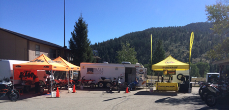
Be sure to check out the Trails Preservation Alliance Facebook page for more photos and updates!
|
||
|
|
||
Mule deer population plan
| |
August 20, 2014 |
|
|
Colorado Parks and Wildlife RE: Mule deer population plan Dear Mr. Velarde; Please accept this correspondence as the comments of the Colorado Snowmobile Association (“CSA”), Trail Preservation Alliance (“TPA”) and Colorado Off-Highway Vehicle Coalition (“COHVCO”) with regard to the development of the mule deer strategic plan as currently reflected in the document entitled “The Story of Colorado’s mule deer” (“The Plan”). Prior to addressing the specific concerns of the Organizations on this issue, a brief summary of the Organizations is necessary to establish the basis for these comments. The Colorado Off- Highway Vehicle Coalition (“COHVCO”) is a grassroots advocacy organization advocating for the approximately 200,000 registered OSV and OHV vehicle users in Colorado seeking to represent, assist, educate, and empower all OHV recreationists in the protection and promotion of off- highway motorized recreation throughout Colorado. COHVCO is an environmental organization that advocates and promotes the responsible use and conservation of our public lands and natural resources to preserve their aesthetic and recreational qualities for future generations. The Trail Preservation Alliance (“TPA”) is a 100 percent volunteer organization whose intention is to be a viable partner, working with the United States Forest Service (USFS) and the Bureau of Land Management (BLM) to preserve the sport of trail riding. The TPA acts as an advocate of the sport and takes the necessary action to insure that the USFS and BLM allocate to trail riding a fair and equitable percentage of access to public lands. Colorado Snowmobile Association (“CSA”) was founded in 1970 to unite winter motorized recreationists across the state to enjoy their passion. CSA advocates for the 30,000 registered snowmobiles in the State of Colorado. CSA has become the voice of organized snowmobiling seeking to advance, promote and preserve the sport of snowmobiling by working with Federal and state land management agencies and local, state and federal legislators. For purposes of these comments, COHVC, CSA and TPA will be referred to as the Organizations. The Organizations thank you for holding the public meeting in Glenwood Springs to address this important issue, and we apologize for not being able to attend that meeting. Please accept this document as our preliminary thoughts on this issue. The Organizations commend CPW for proactively addressing the recent declines in mule deer populations in Colorado. CPW has a long history of proactively addressing wildlife population related issues such as this and the Organizations believe that continuing to manage wildlife population issues proactively must be pursued. The Organizations believe wildlife is a critical component of the hunting experience many of our members enjoy and is a critical component of the high quality recreational experience that has become synonymous with Colorado. The Organizations have a long history of partnering with USFS, BLM and CPW to address wildlife issues on a local level in areas where motorized usage occurs, such as seasonal closures of winter range and calving areas to usage, providing on the ground funding to land managers to address any site specific issues that might be impacting resources and with development of the Stay the Trail program. 1a. Landscape level recreation planning for wildlife. As an initial matter, the Organizations will note that the entire state of Colorado has moved to a designated trail system for motorized travel with the recent release of new Resource Management Plans from several BLM field offices including the Colorado River Valley Office, Kremmling Office and Grand Junction Field Office. The Organizations vigorously assert that these management changes mark the completion of one of the few landscape level management changes for multiple use recreational usage that can benefit wildlife populations. This BLM management change will further reduce possible impacts from off trail usage for a variety of activities including shed collections and other off trail activity that has been prohibited by the USFS for a long period of time. The Organizations are aware that any incremental benefits that can be achieved from additional travel management for the benefit of wildlife are limited after a planning area has moved to a designated route system. The US Forest Service’s Rocky Mountain Research Station has recently released extensive analysis of the effectiveness of travel management restrictions on addressing sensitive species related issues concluding as follows: “Actions such as limiting grazing or closing OHV trails have historically been some of the primary tools used by land managers in southern Nevada to reduce the effects of anthropogenic stressors on species of conservation concern….. It is evident from this body of research that very little is known about the relative threats posed to, or the mitigation actions needed to protect, virtually any species, except perhaps the desert tortoise. Too often research jumps immediately to mitigation strategies without first determining what specific factors pose the greatest threats and are the most important to mitigate. In addition, the evaluation of potential threats typically focuses upon the usual anthropogenic suspects (e.g. OHVs, livestock grazing, invasive species, and climate change) without first carefully considering which factors are most likely to pose the greatest threats.” 1 The National Park Service has echoed these sentiments, when addressing winter travel and usage of the Yellowstone National Park. The Park Service has clearly stated as follows: “Based on these population-level results, we suggest that the debate regarding effects of human winter recreation on wildlife in Yellowstone is largely a social issue as opposed to a wildlife management issue. Effects of winter disturbances on ungulates from motorized and non-motorized uses more likely accrue at the individual animal level (e.g., temporary displacements and acute increases in heart rate or energy expenditures) than at the population scale. A general tolerance of wildlife to human activities is suggested because of the association between locations of large wintering ungulate herds and winter recreation. Habituation to human activities likely reduces the chance for chronic stress or abandonment of critical wintering habitats that could have significant effects at the population level, especially when these activities are relatively predictable.”2 The Organizations believe that the Research Station position is an accurate reflection of best available science on management of species after any planning area has moved to a designated route system, such as that which have now been uniformly been adopted by USFS and BLM in Colorado. The identification of the additional limited benefits is critical in the planning process, as the Organizations are aware that there is and probably always will be, significantly limited funding for the management of all public lands and as a result these funds must be directed toward management changes and priorities that achieve the largest population benefits from those funds. 1b. All usage should be addressed in habitat areas. The Organizations are aware that restrictions on multiple use recreation is frequently seen as the first and most effective management tool to be used for the improvement of habitat areas for wildlife. The Organizations are unsure as to the basis of this management priority as often wildlife displays far higher levels of response to a variety of other activities in a habitat area. In 1999, the Wildlife Society published an extensive analysis of activities that are impacting wildlife habitat. A full chapter of this book was devoted to wildlife response to off leash dogs. 3 The conclusions of this work were summarized as follows: “Authors of many wildlife disturbance studies concluded that dogs with people, dogs on-leash, or loose dogs provoked the most pronounced disturbance reactions from their study animals. …. Dogs extend the zone of human influence when off-leash. Many ungulate species demonstrated more pronounced reactions to unanticipated disturbances, as a dog off-leash would be until within very close range.” The Organizations believe that if landscape level management standards for the usage of habitat are pursued, these management standards must pursue the holistic improvement of this habitat and expand beyond the closure of areas to multiple use recreation. 1c. CPW efforts to minimize the impacts of urbanization of private lands must be highlighted. The Organizations are aware that impacts of urbanization of private lands often results in significant declines in the size and quality of wildlife habitat as a whole and more particularly winter range of all species. The Organizations believe these issues are highlighted by traveling down many of the Colorado state highways. Many areas that were large ranches, where winter range was shared between wildlife and domestic animals, 50 years ago have been converted to subdivisions and other more intensive urbanization of these historic grazing areas. Once these areas are converted to subdivisions, the quality of this range significantly diminishes. Often attempts to offset the impacts from development of private land are inaccurately directed towards restrictions on management and usage of adjacent public lands. These attempts simply have generated minimal benefits and must be avoided moving forward. CPW has proactively addressed these urbanization issues with an active conservation easement program to actively protect habitat areas on private lands from urbanization and other development. The Organizations are aware that these conservation easements have been highly effective in protecting these habitat areas. These private lands are areas that are outside of the NEPA process and where public support for the management is a critical component of the management process. Protecting access to adjacent public lands in order to maintain the public support for the voluntary restrictions that the easements are placing on high quality habitat on adjacent private lands. This relationship must not be overlooked. 1d. Forest Health concerns from Mountain Pine Beetle must be addressed for all species. The Organizations note that recent decline in overall forest health issues are throughout the Rocky Mountain region are not addressed in the Plan. The Organizations believe this is an oversight and that the rapidly decline in forest health resulting from mountain pine beetle and other insect infestations represents a significant challenge for all land managers moving forward. The Organizations are aware that a timber sale on a State Wildlife area can be difficult, but these types of activities are far more difficult on federal public lands and this is an issue where the partnership between federal land managers and CPW must be fully used. The impacts of these infestations has been recognized at the landscape level by the USFS as follows: “Recent studies conducted by the RMRS in forest stands near Fraser, CO suggest that lodgepole pine will remain the dominant species in harvested stands over the next century, but subalpine fir will become the most abundant species in The Colorado State Forest Service recently stated this position, and the large scale impacts that are going to be impacted as follows: “Seventeen of Colorado’s “Species of Greatest Conservation Need,” as identified by Colorado Parks and Wildlife, rely on spruce-fir forests for their primary habitat. Change in forest cover of spruce-fir forests could negatively impact the habitat of these species.”5 Many recently released management documents for specific species have echoed these sentiments regarding the decline in habitat quality as a result of insect infestations. In 2013, the USFWS identified the degraded habitat that results from the mountain pine beetle outbreak as a first tier anthropogenic influence on the quality of Lynx habitat. This concern is reflected as: “An increasing occurrence and persistence of drought, along with associated insect outbreaks and wildfires, could rapidly and dramatically affect the distribution, amount, and composition of lynx habitat”6 The Organizations believe that the impacts to all wildlife habitat from the mountain pine beetle is a major concern moving forward. The Organizations believe that resolution of these impacts, to the extent possible, must be a priority for the management of any wildlife habitat areas moving forward. The Organizations believe that identification of this issue in the Plan will allow discussions and resources to target this issue moving forward and allow for complete utilization of limited resources. 2. Conclusion. The Organizations applaud CPW for continuing the proactive management of species in Colorado with the development of the Mule Deer Plan. The Organizations believe that best available science is a critical component of proactive management of habitat issues and that accurately applying best available science must be performed to allow limited budgets of all land managers to be accurately and meaningfully applied to obtain maximum benefit for the species. Please feel free to contact Scott Jones, Esq if you should wish to discuss any of the issues that have been raised in these comments further. His contact information is Scott Jones, Esq., 508 Respectfully Submitted, Scott Jones, Esq. Don Riggle Randall Miller Brian O’Connors
1 See, USDA Forest Service, Rocky Mountain Research Station; The Southern Nevada Agency Partnership Science and Research Synthesis; Science to Support Land Management in Southern Nevada; Executive Summary ; August 2013 at pg 38. 2 See, US Park Service; White and Davis; Wildlife response to motorized recreation in the Yellowstone Park; 2005 annual report; at pg 15. 3 See, Sime, C. A. 1999. Domestic Dogs in Wildlife Habitats. Pages 8.1-8.17 in G. Joslin and H. Youmans, coordinators. Effects of recreation on Rocky Mountain wildlife: A Review for Montana. Committee on Effects of Recreation on Wildlife, Montana Chapter of the Wildlife Society. 307pp. 4 See, USDA Forest Service; Rocky Mountain Research Station; A Review of the USFS Response to the Mountain Pine Beetle Outbreak in Northern Colorado and Southern Wyoming; September 2011 at pg. 18. 5 See, Colorado State Forest Service; Quick Guide Series; Spruce Beetle; FM 2014-1 at pg 6. 6 See, Interagency Lynx Biology Team. 2013. Canada lynx conservation assessment and strategy. 3rd edition. USDA Forest Service, USDI Fish and Wildlife Service, USDI Bureau of Land Management, and USDI National Park Service. Forest Service Publication R1-13-19, Missoula, MT. 128 pp at pg 70.
|
||
|
|
||
San Carlos RD TAP Addendum
| |
August 11, 2014 |
|
|
San Carlos Ranger District RE: San Carlos RD TAP Addendum Dear Mr. Baumchen; Please accept this correspondence as the comments of the above Organization with regard to the San Carlos RD (“SCRD”) TAP addendum. Prior to addressing the specific merits of the Travel Analysis Process Report Addendum (“TAP Addendum”), we believe a brief summary of each Organization is needed. The Colorado Off-Highway Vehicle Coalition (“COHVCO”) is a grassroots advocacy organization of representing the 200,000 registered OHVs in the State of Colorado seeking to represent, assist, educate, and empower all OHV recreationists in the protection and promotion of off-highway motorized recreation throughout Colorado. COHVCO is an environmental organization that advocates and promotes the responsible use and conservation of our public lands and natural resources to preserve their aesthetic and recreational qualities for future generations. The Trail Preservation Alliance (“TPA”) is a 100 percent volunteer organization whose intention is to be a viable partner, working with the United States Forest Service (USFS) and the Bureau of Land Management (BLM) to preserve the sport of trail riding. The TPA acts as an advocate of the sport and takes the necessary action to insure that the USFS and BLM allocate to trail riding a fair and equitable percentage of access to public lands. For purposes of these comments, COHVCO and TPA are referred to as “the Organizations”. The Organizations would like to thank you for this opportunity to comment on the TAP Addendum. 1. Executive Summary 1. The Organizations support that a high percentage of routes are identified as highly valued; 2. The Organizations support the removal of the lynx habitat as a risk analysis point; 3. Cutthroat trout habitat issues are unrelated to roads and trails and as a result the analysis of cutthroat trout habitat as a high risk concern is unwarranted; 4. The TAP fails to address new clarity in the management of the Preble’s Meadow Jumping Mouse that has been provided in very recent listing decisions with regard to the New Mexico Jumping Mouse; 5. Spotted Owl habitat issues are unrelated to roads and trails; and 6. Resolution of trails budget issues must address all trails usage rather than just multiple use routes as most trails are not open to motorized use. 2. All multiple use routes are valuable. The Organizations vigorously support the TAP Addendum conclusions that all routes on the San Carlos RD are highly valuable, as they each provide a unique and different recreational experience and provide access to separate and different portions of the RD for a wide range of recreational experiences. The Organizations vigorously support the accurate reflection of this value in the TAP addendum. The Organizations are concerned that the single route that is identified as a Low/High route on the SCRD (USFS RD 120 on map 4 of 6) provides the sole means of access to a major portion of the Sangre De Cristo Wilderness for recreational activity. It is the Organizations belief that this route is highly valuable as a resource for the minimization of user conflicts on the SCRD. It has been the Organizations experience that often conflict of users results from improper matching of desired recreational opportunities with desired experiences, rather than a lack of opportunities. Wilderness areas frequently highlight these issues as users are completely unable to access to these areas for quiet use opportunities. The Organizations are aware that closure of routes outside the Wilderness areas are provided to improve quiet use recreational activities is often used to address these conflicts. The Organizations believe that maintaining this route and educating users regarding the extensive quiet use opportunities in the area is a far superior method of resolving user conflicts, when compared to the closure of multiple use routes and opportunities on other parts of the SCRD in an attempt to try and create quiet use recreational opportunities. 3a. Landscape level wildlife management is often unrelated to travel management. The US Forest Service’s Rocky Mountain Research Station has recently released extensive analysis of the effectiveness of travel management restrictions on addressing sensitive species related issues. These conclusions specifically found that travel management was not effective in addressing these issues and the species related concerns were often beyond the scope of travel management to address. The Research Station conclusions specifically stated as follows: “Actions such as limiting grazing or closing OHV trails have historically been some of the primary tools used by land managers in southern Nevada to reduce the effects of anthropogenic stressors on species of conservation concern….. It is evident from this body of research that very little is known about the relative threats posed to, or the mitigation actions needed to protect, virtually any species, except perhaps the desert tortoise. Too often research jumps immediately to mitigation strategies without first determining what specific factors pose the greatest threats and are the most important to mitigate. In addition, the evaluation of potential threats typically focuses upon the usual anthropogenic suspects (e.g. OHVs, livestock grazing, invasive species, and climate change) without first carefully considering which factors are most likely to pose the greatest threats.” 1 The Organizations firmly believe that roads and trails can exist in partnership with wildlife and that often the threats to wildlife are unrelated to the existence of roads and trails in the habitat areas. The Organizations believe that many of the species specific factors that are identified as heightened risk factors are the result of an overabundance of caution in dealing with these species, which the Organizations understand. The Organizations believe that directing limited resources toward the actual threats to the species is the only way to resolve these issues, and ongoing funding of the analysis of roads and trails, which is at most a secondary threat to species is not the best allocation of these limited resources. 3b. Lynx Management updates have been reflected in the TAP addendum. The Organizations note that possible lynx habitat issues have been removed from priority of threats for the analysis roads usage in the SCRD TAP when compared to the 2009 TAP for the Pike/San Isabel NF as a whole. The Organizations vigorously support this change to reflect best available science on the species as reflected in the 2013 Lynx Conservation Assessment and Strategy (“LCAS”) recently issued by the USFS, USFWS and BLM. This new LCSAS clearly stated that road and trail density does not impact the quality of an area as lynx habitat 2 and that there is no information to suggest that trails have a negative impact on lynx.3 The Organizations were thrilled at this change was incorporated in the SCRD TAP Addendum as many in the USFS are simply unaware of the recent changes to lynx management standards. 3c(1). Cutthroat Trout habitat management issues are inaccurately reflected as a high risk issue for road and trail management. The Organizations are concerned that the greenback cutthroat trout remains a priority issues on decision matrix for risks from roads and trails.4 The Organizations do not contest that a lack of habitat is an identified concern for the protection of the genetically pure Greenback Cutthroat Trout. The Organizations vigorously assert that the relationship between roads and trails and the genetically pure trout is tenuous at best, as the lack of habitat for the greenback Cutthroat Trout is the result of almost 1 billion hybrid fish being reintroduced into Colorado waterways rather than any issues with roads and trails. The hybrid fish consistently out reproduce, hybridize, generally outperform or eat the native cutthroat trout that may remain in any waterways, making separation of habitat of the species the major priority in management. The Organizations respectfully submit that all roads and trails in Colorado could be closed and it simply would have no impact on the lack of cutthroat trout habitat as a species. The Organizations will briefly outline this research in order to support our position on this issue. Researchers have concluded that management of sensitive trout species has occurred in habitat areas where there are extensive routes and trails available. Researchers have specifically found: “Study streams were accessible by road or trail and generally supported good to excellent habitat conditions.” 5 Clearly, these issues are not mutually exclusive usages and the weak relationship between the two concerns has been clearly addressed by the USFWS. The 2009 FWS listing decision for the Greenback Cutthroat Trout provided a limited discussion regarding the three factors for effective trout habitat scope and types of habitat issues that are faced by the Cutthroat trout. This report clearly states: “Since completion of the 1998 Recovery Plan, extensive study has been devoted to determining how habitat quality and translocation success are related. Harig and Fausch (2002) developed a model, based on a comparative field study, which predicted that cold summer water temperature, narrow stream width, and lack of deep pools limited translocation success of the greenback. Young and Guenther-Gloss (2004) evaluated the model developed by Harig and Fausch (2002), and found a positive correlation between the three model components and greenback abundance.” 6 Decomposed granite is widely present throughout Colorado and is highly mobile and unstable, with or without recreational usage and these issues are compounded by the steep slopes that are prevalent statewide. The Manitou Springs flooding over the last several years has provided clear evidence of this. The Organizations are also aware that often any sedimentation issues are unrelated to motorized roads and trails as dispersed camping, non-motorized trails and a general lack of ground cover can significantly impact erosion rates as well. The Organizations are unsure if removal of recreational usage of the area will stop the erosion related issues that are facing the Greenbacks and many impacts can be removed with proper road and trail maintenance. The 2009 FWS 5 year listing decision on the Greenback cutthroat trout continued to address roads and trails and clearly states trails usage is a low level threat to the cutthroat trout habitat as follows: “Low level threats include the ongoing negative effects of past mining operations on water quality; the impacts of grazing, logging, and road and trail construction and use on riparian habitat and streambanks, causing increased erosion, sediment deposition, and in turn elevated water temperatures and higher turbidity; and the co-occurrence of nonnative salmonids with greenback populations.” 7 The 5 year listing decision specifically states land managers have a significant amount of latitude in addressing these low level threats to the trout. The listing decision recommended management of this issue as follows: “Regulatory and land management agencies have the ability to improve habitat conditions and eliminate or minimize these threats by…. by implementing conservation measures to avoid streamside habitat degradation while approving new grazing, logging, and road and trail construction proposals; by moving existing roads and trails away from streamside habitats and rehabilitating disturbed riparian habitats;….. All of these positive activities are ongoing throughout the subspecies’ range and are implemented based on agency priorities and funding levels on an annual basis.” 8 Given that USFWS listing decisions and a wide range of other credible research have identified roads and trails as a minimal threat to the Cutthroat trout habitat, the Organizations are opposed to any prioritization of roads or trails that might be adjacent to areas that may have genetically pure fish in the waterways. 3c(2). The recent Metcalf article on genetically pure greenback trout does not alter the minimal risk of road and trails to genetically pure Trout. The Organizations are aware of the major discussions that have occurred with the federal agencies regarding the implications of the recently released Metcalf article which called into question the overall population size and implications to management of the Greenback cutthroat trout as a species. The Organizations believe that this article may impact the size of native/pure greenback trout populations but do not believe that the article will change the priority and scale of the threats to the Greenback. The Metcalf article has prompted numerous meetings within federal agencies such as the meeting last year in Denver with USFWS resulted in spirited discussions regarding report and analysis. To say the designation of the species for management moving forward is somewhat unclear would be accurate. As part of the article development, Mr. Metcalf extensively researched the Bear Creek watershed on the Pike Peak Ranger district and it should be noted that at no point are roads and trails identified or discussed as a possible threat to the greenback trout in the Bear Creek watershed despite extensive on site analysis of the Bear Creek area by researchers. This article immediately moves to analysis and discussion of the restocking efforts that have been undertaken in the Bear Creek area and the devastating effects that restocking 750 million other species of trout that out compete the native fish have had throughout Colorado. This threat analysis is consistent with the management documents that have been previously created by the USFWS and CPW for the management of the species. In addition to the vigorous discussions currently occurring on the true implications of the Metcalf article with regard to species populations, there is a well established body of research on management of greenback cutthroat trout, which is relevant in the TAP Addendum planning. This management and analysis has specifically concluded: “Between 1885 and 1953 there were 41,014 documented fish stocking events in Colorado by state or federal agencies. The vast majority of these involved brook trout (Salvelinus fontinalis), rainbow trout (Oncorhynchus mykiss) and cutthroat trout (O. clarkii) (Fig. 3, supporting information). Remarkably, over 750 million fish of these three species were stocked from hatcheries into streams and lakes in Colorado over this period of time. Introductions of brook trout and rainbow trout probably had devastating effects on native cutthroat trout populations because brook trout are superior competitors and rainbow trout hybridize with cutthroat trout (Young & Harig 2001).” 9 The June 2006 Conservation Strategy and Assessment agreement between FWS and the Forest Service provides 7 objectives and 11 strategies for the Colorado Cutthroat trout, all of which seek to address the impacts of stocking 750 million threats to the cutthroat trout. 10 Possible impacts from roads and trails that might be in habitat areas is simply never even mentioned and the Organizations assert the continued failures to review this issue leads to one conclusion, which is the usage of roads and trails is at most a minimal threat, if it is one at all. 4. The TAP fails to address recent determinations on roads and trails in Jumping Mouse habitat. The Organizations believe our concerns regarding the Preble’s Meadow Jumping Mouse are the result of recent activity from the USFWS on the status of the New Mexico Jumping Mouse. The Organizations are aware that consolidated or landscape level management documents are rather sparse regarding the Preble’s Meadow Jumping Mouse, as a result of its 4(f) classification. Conservation agreements and measures for the Preble’s Meadow Jumping Mouse have been performed at a very localized level in Douglas and El Paso Counties, but are of limited value at the landscape level. While there has been analysis of trail projects, this analysis has been for exceptionally small areas and of little large scale relevance. As a result of the limited analysis available for the jumping mouse generally, frequently research regarding similar species are used interchangeably. The New Mexico Jumping Mouse and Preble’s Meadow Jumping Mouse would be such a situation, and the distinctions of these species has led to some very public confrontations between researchers. The New Mexico Jumping Mouse listing decision issued by the USFWS on June 10, 2014 clearly stated the lack of relationship between roads and trails and possible population declines with the jumping mouse as follows: “(13) Comment: Roads are not listed as a factor affecting the New Mexico meadow jumping mouse; however, dirt roads can cause indirect effects through sedimentation or by impeding spring flows.Our Response: We acknowledge that it is possible for roads to indirectly or directly impact riparian areas, springs, or New Mexico meadow jumping mouse habitat. However, the USFS did not provide any specific information for us to consider and the best available scientific and commercial data does not indicate how or where dirt roads may be causing indirect effects to New Mexico meadow jumping mouse habitat through sedimentation or by impeding spring flows now or in the future.” 11 Previous draft conservation assessments for the Preble’s Meadow Jumping Mouse have referenced investigations regarding the Preble’s Meadow Jumping Mouse had identified a possible exceptionally weak relationship between the existence of trails and a decline in Jumping mouse populations and these conclusions failed to discriminate between a variety of other factors that might be impacting the conclusions and were not isolated out of the investigation process. The summary of one year of this investigation is as follows: “Trail systems frequently parallel or intersect riparian communities within Colorado. The development of trail systems may impact Prebles by modifying its habitat, nesting sites, and food resources in both riparian and upland areas. Humans and pets using these trails may alter behavior patterns of Prebles and cause a decrease in survival and reproductive success. There was a 28% decrease (although not statistically significant, p = 0.226) in population density of Prebles adjacent to trails, compared with sites without trails along South Boulder Creek, Boulder County (Meaney et al. in press).” 12 The Organizations have been able to obtain the Meaney documents and believe these documents are most accurately summarized as data rather than research, and the Organizations are unable to locate any publications of this data for peer review. The Organizations again have to question any heightened risk factors being attributed to roads ortrails that might be in Preble’s Meadow Jumping Mouse habitat, as the USFWS has recently specifically stated it does not believe there is any correlation between these factors. The TAP Addendum must be updated to reflect this change. 5. Mexican Spotted Owl habitat is not impaired by road or trail usage. The Organizations also note that a heightened risk factor is attributed to the possibility of Mexican spotted owl habitat. The Organizations believe it is again relevant to review the primary threats to the Mexican Spotted Owl, which are timber harvest and wildfire.13 The USFWS Mexican Spotted Owl recovery plan provides the following summary of possible issues to the species from roads and trails: “ix. Roads and Trails The management guidelines that are provided in Appendix C of the recovery plan fall well short of providing a basis for a general heightened risk factor being attributed to Spotted Owl habitat as the guidelines specifically state that at most a seasonal closure of routes might be required. The complete roads and trails guidelines are as follows: “Guidelines Again the Organizations believe these guidelines fall well short of warranting a heightened risk factor being attributed to roads and trails that might be falling in a possible habitat area, as seasonal closures are the highest levels of protections for habitat areas and are clearly identified as discretionary at most. 6. USFS budget issues and roads and trails maintenance. The Organizations are aware that the Government Accountability Office recently issued a report addressing the financial sustainability of roads and trails on USFS lands, and concluded that only 25% of USFS roads and trails are financially sustainable. 16 Given the stark nature of these conclusions, the Organizations believe a complete understanding of the conclusions is critical to the management and resolution of this issue, as the TAP Addendum provides an extensive discussion of maintenance costs for roads and trails. The GAO analysis is very large in scope and addresses all types of trail usage including non-motorized routes in Wilderness areas. The GAO report identifies that non-motorized routes in Wilderness areas on Forest Service lands account for 20% of the total mileage of all Forest Service routes but only results in 4% of all visitor days to public lands and that only 37% of all USFS routes are even open to motorized usage, despite the relationship that these routes play for all recreational usage of public lands. 17 Given that all routes are accessed by motorized routes, motorized routes are a critical component of all recreational activity. Maintenance of non-motorized Wilderness routes is exceptionally expensive when compared to multiple use routes, due to management limitations on types of management, limited access to areas and many of these routes have been heavily impacted by intense wildfire and Forest health issues. The Organizations would also note that attempts to address this budget issue with just the closure of motorized routes would be unsuccessful given the small portion of routes that are open to this usage. In the GAO report, State OHV grant programs are specifically recognized as a significant contributor to maintenance of multiple use routes, even if these funding sources were not tracked by the Forest Service. Motorized grant programs have been providing a wide range of funding to the management of recreational routes on the SCRD, through the direct funding of projects and a good management crew through the CPW OHV grant program. No similar program exists for the maintenance of non-motorized routes, compounding existing budget limitations. The loss of multiple use routes erodes user support for registration programs, such as the CPW OHV grant program, that provide significant effective funding for maintenance of multiple use routes and negatively impacts users desire to volunteer for maintenance activities. As such the Organizations would be opposed to any management that did not address all usages in an attempt to resolve these budget issues. 5. Conclusion. The Organizations support the TAP Addendum with minor modifications noted in these comments. The Organizations are aware that there are significant budgetary limitations on trails and roads in the USFS, which the Organizations have partnered with the CPW OHV grant program in an attempt to assist in resolving these issues. However the Organizations are aware these budget issues remain unresolved and believe that as a result any funding that is available must be used to its maximum benefit. The Organizations believe that part of this use involves identifying issues that are impacted by road or trail usage but also as importantly excluding issues that are not related to roads and trails from the road and trail management process as early as possible. As such the Organizations believe that priority threats should only reflect issues where best available science has concluded that roads and trails are a serious threat to the species. Please feel free to contact Scott Jones, Esq. if you should wish to discuss any of the issues that have been raised in these comments further. His contact information is Scott Jones, Esq., 508 Ashford Drive, Longmont Colorado 80504; phone 518-281-5810 ; email Scott.jones46@yahoo.com Respectfully Submitted, Scott Jones, Esq. D.E. Riggle Brian O’Connors
1 See, USDA Forest Service, Rocky Mountain Research Station; The Southern Nevada Agency Partnership Science and Research Synthesis; Science to Support Land Management in Southern Nevada; Executive Summary; August 2013 at pg 38. 2 See, See, Interagency Lynx Biology Team. 2013. Canada lynx conservation assessment and strategy. 3rd edition. USDA Forest Service, USDI Fish and Wildlife Service, USDI Bureau of Land Management, and USDI National Park Service. Forest Service Publication R1-13-19, Missoula, MT. 128 at pg 95. Hereinafter referred to as the 2013 LCAS. 3 See, 2013 LCAS at pg 84. 4 See, TAP Addendum at pg 5-5. 5 See, Rocky Mountain Research Station; McGrath and Scott; WESTSLOPE CUTTHROAT TROUT LENGTH VARIATION; North American Journal of Fisheries Management 28:1529–1540, 2008 6 See, USFWS Greenback Cutthroat Trout (Oncorhynchus clarki stomias)5-Year Review: Summary and Evaluation 5 year listing decision May 2009 at pg 11. This document is hereinafter referred to as the Trout 5 year listing. 7 See, USFWS Trout 5 year listing at pg 34 8 See, USFWS Trout 5 year listing at pg 34-35. 9 Metcalf et al; Historical stocking data and 19th century DNA reveal human-induced changes to native diversity and distribution of cutthroat; Molecular Ecology (2012) 21, 5194–5207. 10 CRCT Conservation Team. 2006. Conservation agreement for Colorado River cutthroat trout (Oncorhynchus clarkii pleuriticus) in the States of Colorado, Utah, and Wyoming. Colorado Division of Wildlife, Fort Collins. at pg 3-4. 11 See, Fish and Wildlife Service, Endangered and Threatened Wildlife and Plants; Determination of Endangered Status for the New Mexico Meadow Jumping Mouse Throughout Its Range, Federal Register June 10, 2014; at 33125 12 See, Draft 2003 Conservation Assessment and Strategy at pg 14. 13 See, USFWS website on Mexican Spotted Owl; http://www.fws.gov/southwest/es/MSO_RecoveryPlan.html accessed August 11, 2014. 14 See, USFWS; Mexican Spotted Owl Recovery Plan; second adoption; September 2012 at pg 45. 15 See, Spotted Owl Recovery plan Appendix C at pg 294 16 See, Government Accountability Office report 13-618; Forest Service Trails; Long and Short term improvements could reduce maintenance backlogs and enhance systems sustainability. June 2013. Complete report is available here: http://www.gao.gov/assets/660/655555.pdf 17 See, GAO report at pg 50.
|
||
|
|
||
Over the Snow Travel Rule
| |
July 31, 2014 |
|
|
U.S. Forest Service RE: Over the Snow Travel Rule Dear Mr. Adamson; The Colorado Off-Highway Vehicle Coalition (“COHVCO”) is a grassroots advocacy organization advocating for the approximately 200,000 registered OSV and OHV vehicle users in Colorado 2 seeking to represent, assist, educate, and empower all OHV recreationists in the protection and promotion of off-highway motorized recreation throughout Colorado. COHVCO is an environmental organization that advocates and promotes the responsible use and conservation of our public lands and natural resources to preserve their aesthetic and recreational qualities for future generations. The Trail Preservation Alliance (“TPA”) is a 100 percent volunteer organization whose intention is to be a viable partner, working with the United States Forest Service (USFS) and the Bureau of Land Management (BLM) to preserve the sport of trail riding. The TPA acts as an advocate of the sport and takes the necessary action to insure that the USFS and BLM allocate to trail riding a fair and equitable percentage of access to public lands. The New Mexico Off Highway Vehicle Alliance (NMOHVA) is a statewide incorporated alliance of motorized off-highway vehicle enthusiasts that promotes responsible OHV recreation through education, safety training, land conservation and access, in cooperation with public and private interests, to ensure a positive future for OHV recreation in New Mexico. NMOHVA represent motorized recreationists in New Mexico including 4WD enthusiasts, dirt bike riders, ATV users, and “over the snow” vehicle enthusiasts. NMOHVA has not been in existence long enough to claim the same extensive experience or expertise in working with land management agencies on winter travel plans as the above Organizations. Nevertheless, we have read and fully approve of the following comments. New Mexico has extensive snowmobiling on Forest Service managed lands and our membership will be affected greatly by the new rule and any subsequent winter travel management plans. For purposes of these comments, Colorado Off-Highway Vehicle Coalition, the Trail Preservation Alliance and Colorado Snowmobile Association will be referred to as “the Organizations” in these comments. Executive summary of comments. 1. Background. As a result of the long time partnerships between USFS land managers in Colorado and the Organizations, the Organizations have significant experience with the winter travel management process. Numerous forests in Colorado have undertaken winter planning for either relevant portions of the forests or the forest planning area in its entirety. Our comments will be directed toward concerns for forests where winter travel management is an issue, as the Organizations believe that Forests that never receive snow will undergo a very simple and straight forward review of winter travel as they do not receive snow consistently, if at all. It is the Organizations intent to provide the benefit of some of our experiences with the winter travel planning process in these comments, both with regard to the Rule and to address issues that may be encountered in implementation of the Rule. A smooth rollout of the revised Rule will insure that the high quality winter recreational opportunities provided on public lands continue to be provided next winter and that the Idaho Court’s decision that essentially made much ado out of nothing rapidly fades into the past. 2. The Rule properly continues application of winter travel management decisions that have been adopted. The Organizations vigorously support the determination in the Rule that existing winter travel management decisions must not be disturbed and the Organizations would be vigorously opposed to any attempts to reset or in any way alter winter travel management decisions that are currently in place. While the winter portions of the travel management rule may have been struck down by the Idaho court, the USFS general planning authority for resources undertaken pursuant to NEPA remains a valid and legally sufficient basis for carrying current management decisions forward. Many of these NEPA decisions directly address winter travel issues. The Organizations have been active partners in the development and implementation of winter travel decisions in the State of Colorado since our grooming activities started in the late 1970’s. As a result of this partnership, that is now approaching 40 years in length, the Organizations can confirm that management of winter recreation was occurring under USFS general NEPA jurisdiction for resource management well before issuance of the 2005 Travel Management Rule. This management was more formalized in some areas than other but all decisions were identifying areas where snowmobile usage was not restricted to trails, areas where usage was restricted to trails and where snowmobile usage was entirely prohibited. The identification of snowmobile management standards might have been rather simple when grooming activities began such as: identifying groomed routes with special use permits; identification of parking areas and signage; marking boundaries of Wilderness areas and excluding usage from wildlife winter ranges. These decisions were undertaken pursuant to NEPA guidelines and general planning authorities of the USFS and remain valid management prescriptions that would require NEPA analysis to alter. While these older resource management plan decisions may not be as technically advanced in the memorialization of boundaries and other restrictions as decisions made more recently, these decisions remain valid applications of general planning authority of the USFS and done under NEPA guidelines, outside any changes to winter travel management rule that was addressed in the Idaho Court decision. As such, the Organizations vigorously assert these decisions must be honored and carried forward. 3a. The Organizations support adoption of alternative regulatory baselines for over the snow travel. The Organizations vigorously support the Rule adoption of management of over the snow travel with alternative baselines for management, mainly adopting both a “closed unless designated open” standard and an “open unless closed” standard to be determined at the discretion of the local land managers. The Organizations would be vigorously opposed to any attempts at revision of the Rule to try to move towards an entirely designated route system in the Western United States and the Organizations are equally aware that many eastern United States associations would be vigorously opposed to changes to the closed unless open standards applied on eastern united states forests for reasons that are entirely unrelated to public lands management. These alternative baselines are critically important in carrying forward existing NEPA decisions and effective local management. As the Rule discusses, winter conditions in the Western United States are significantly different than those that are found in the Eastern United States, both in terms of the type of snow that falls, frequency of snow fall and amounts of snow that are received. This factor weighs exceptionally heavily in maintaining in the open unless closed standards that predominate winter travel management in the western united states. The significantly higher levels of snowfall that many areas in the Western United States receives mitigate any possible impacts to resources on the ground, which is the primary basis for a designated route system in areas that might receive lesser snowfall. The levels of resource protection provided by the large snowfall are common place in the Western United States and weigh heavily in winter travel management based on large open areas. It has been the Organizations experience that many winter motorized users are shocked when they visit large winter play areas in the summer for the first time. Their shock results from many of these large play areas being boulder fields in the summer and completely unrideable. The Organizations are also aware that there are significantly different recreational cultures of snowmobile usage and supporting resources between western United States, where snowmobile usage occurs primarily on public lands, and Eastern United States, where snowmobile recreation occurs primarily on private lands with negotiated rights of way that have been obtained by snowmobile clubs. This cultural factor for the snowmobile community factor weighs heavily in many eastern associations desire to maintain a designated route system with only small open areas but is completely irrelevant to the Western United States. The Organizations vigorously assert that USFS winter travel planning guidance documents and maps issued at the local level must clearly and boldly state if the local area is using a “closed unless open” standard or an “open unless closed” standard to avoid confusion of users. This must be clearly provided in each locality to avoid confusion of users who may be on vacation or otherwise unfamiliar with local regulations and in good faith have applied the wrong baseline for management. 3b. The Organizations vigorously support identification that open areas for winter travel are significantly larger than summer designations. The Organizations vigorously support the development of a winter travel specific definition of an “open area” under §212.1 and its recognition that an open area for winter usage is often significantly larger than an open area definition for summer travel management. The Organizations support this decision as the large open areas are a critical component of many of the riding areas in the Western United States, and are the real reason that a winter groomed trail in the area exists. Any attempts to manage winter travel pursuant to summer boundaries are often of very limited effectiveness in winter conditions, as the summer boundary is often buried under numerous feet of snow and have limited relevance for winter travel management concerns. Posting of arbitrarily small boundaries would be very expensive, difficult and time consuming at local levels in the west simply due to the rapidly changing weather conditions. The Organizations believe that significant restrictions on large open riding areas in the western United States could have significant unanticipated consequences in terms of user safety. Often mountain passes that are the basis of western riding areas can receive several feet of snow in an afternoon, while lower elevation lands adjacent to the pass never see a flake of snow. With the current large open riding areas in the Western United States, riders are able to avoid areas of groomed trails that might have become drifted across in unexpected storms or heavy wind events or have become blocked by recent avalanches in the area and have not yet been groomed to correct these temporary conditions. These are concerns that an exclusively designated trail system would be poorly suited to address, as most grooming equipment is unable to exceed 10 mph under optimal conditions, there can be a significant delay between a weather event impacting a trail or area and equipment being able to reach these backcountry areas to address these safety issues. Often these unexpected drifts or avalanche fields can be numerous feet in height and difficult for even the most experienced riders to traverse. The Organizations do not believe the idea of a novice or young rider attempting to drop off a large snowdrifts to stay on the trail presents a safe or desirable scenario for land managers or riders. Large open riding areas allow riders to avoid any localized unsafe conditions and then rejoin the route in an area where the drifts or other safety issues are no longer present, where the worst situation to be encountered. This flexibility of access provided by open riding areas would result in route options being available to riders where largest risk would be getting temporarily stuck rather than the serious injuries that could result from falling off drifts or getting caught in secondary avalanche fields. 3c. Significant negative economic impacts to Western Communities by moving away from large open riding areas that are a cornerstone of the experience. The Organizations are very concerned that any large scale movement away from current NEPA decisions for winter travel management, such as requiring significant restrictions or limitations on the size of winter open area designations and would have serious economic implications to local economies throughout the western United States. While there are trail networks in the riding areas, often these western trail networks are merely a resource for gaining access to the large open riding areas that the Western United States has become famous for. It has been the Organizations experience that while many of the snowmobiles used in the Western United States are exceptionally good in the deep snow found in off trail areas, they are also not well suited for extended trail usage or traveling long distances. Many riders from the western United States simply have no interest in trail riding opportunities, regardless of how developed they may be and are also poorly equipped to trail ride. Snowmobile recreation is a significant economic driver for many western states and provides $34 billion in annual economic contribution to the US and Canada.1 Annually snowmobile recreation provides over $100 million in economic contribution and accounts for almost 1,000 jobs to the State of Colorado alone.2 USFS research indicates that motorized winter recreational usage provides a similar per day economic contribution to local communities as downhill skiing.3 Economic contributions from winter motorized travel are frequently centered in small communities that might be otherwise economically unsustainable in the winter. Often these local communities have lost more traditional sources of revenue, such as timber and mining revenues, making the community overly dependent on recreational income. The loss of winter motorized revenues could seriously impair these communities ability to provide basic services, such as winter road maintenance and schools, to that community. These impacts must not be overlooked. The National Park Service experiences with snowmobile usage in Yellowstone National Park provide concrete proof of the negative economic impacts that would accrue to local communities if large open areas were closed in favor of a designated route system in the Western United States. Prior to 2004, snowmobile usage in Yellowstone was an active economic driver for many of the local communities. In 2004, Yellowstone National Park moved to an entirely designated trail system and other significant restrictions on usage, after implementation of these new rules many of these communities adjacent to the Yellowstone National Park entrances are now summarized a winter time ghost towns, as other user groups have not been drawn to the Park in sufficient numbers to offset the lost visitation of the motorized community. Wyoming State Parks recently studied the decline in Yellowstone winter visitation and determined that users simply have no desire to recreate on a designated trail system without the large open areas. This study clearly stated the overwhelming preference of winter motorized users as follows:
The Organizations vigorously assert that the economic impacts that would result in any movement of existing areas that are managed under an open unless closed standard or closures of existing large winter open areas must be addressed. Motorized winter recreation is a significant economic driver for many western communities and states and it has been conclusively proven by management changes of winter motorized recreation in Yellowstone National Park, that moving to an entirely designated route system would have massive negative impacts to local communities, which have become overly reliant on recreational usage of adjacent public lands for economic activity. 4a. The Organizations believe the flexible implementation schedule will allow managers to avoid pitfalls of summer MVUM development The Organizations have noted that there is no hard deadline for the final release of winter travel management maps for those forests or districts who may need to more fully develop or memorialize existing winter travel decisions. This is a significant change from implementation of the summer travel management process, where a hard release date for these materials was provided as a result. Some forests provided less than defendable maps and information for summer travel management in an attempt to comply with this deadline, and these forests are still struggling with the ramifications of these decisions both in terms of lawsuits and frustration of users. The Organizations believe the flexible implementation schedule for development of winter MVUM maps makes good sense for three reasons. First, many forests with snowmobile usage do have sufficient maps in place to satisfy the new Rule requirements, minimizing any concerns about resource impacts in these areas. Secondly, a major driving force for the hard deadline for summer travel, mitigating resource impacts from user created routes, is a minimal concern for winter travel management due to the buffer of snow between recreational users and any resources that could be impacted. Risks of resource impacts from user created routes is further mitigated in the Western United States with the previous identification of large open riding areas where usage has already been subject to NEPA review for possible impacts. The final reason that the flexible implementation schedule makes sense is that winter travel management boundaries are probably more difficult to map that summer routes. It has been the Organizations experience that often natural boundaries, such as ridges, draws or small canyons and treelines, are used as the boundaries for open riding area designations. Reflecting these types of natural boundaries on a paper map will require additional information to be provided on any winter MVUMs. The Organizations believe that compiling and coordinating this information with existing decisions will be more complex and time consuming than mapping of routes did for summer. The Organizations are aware that merely mapping summer routes was a standard easily stated on paper but proved to be far more difficult to apply on the ground. Providing this information in the proper format for users will be an important step in implementation of these maps. Rolling out high quality information will be a significant step in obtaining effective implementation of any rule, as winter travel designation are not as easily mapped as the summer routes are. It has been the Organizations experience that some forests, such as the White River NF have already fully addressed winter travel with the application of modern mapping and analysis methods, while other Forests such as the Pike/San Isabel or Arapahoe/Roosevelt continue to apply older forest plans with site specific management of areas used for winter motorized travel. Many forests operating under older forest plans have performed necessary NEPA analysis as boundary areas for winter travel are identified and routes have been designated, albeit with hand drawn boundaries on USGS maps or other technology that has become outdated. The Organizations believe an example of what these forests may be starting with for winter travel management mapping will substantiate our concerns and the highly valuable nature of this additional time will be to develop high quality and user friendly MVUM for these forests. While many areas of even these forests have moved beyond these memorializations, many are still relying on these RMP maps. The Lump Gulch area on the Boulder Ranger District of the Arapahoe/Roosevelt National Forest provides an example of this situation. The 1997 Arapahoe/ Roosevelt Resource Management Plan provides the following analysis and boundaries of all motorized usage, including snowmobiles, of the Lump Gulch area: The 1997 RMP provides an extensive discussion of summer routes in the area and also specifically addressed winter usage of the Lump Gulch area as follows:
“This will be accomplished in the West Magnolia and Winiger Ridge portions of the geographic areas by closing roads to motorized vehicles, including snowmobiles, during winter and spring” 6 This 1997 RMP analysis and boundary identification simply is not provided in a manner that translates and memorializes well to modern mapping or consolidation into a larger Ranger District or Forest level maps. While the Sulphur Ranger district of the Arapahoe/Roosevelt National Forest has more developed resources7, as a result of more extensive usage, it does not mean the areas with less intensive usage are less desired by the motorized community. Often these areas of less intensive usage on the Arapahoe/Roosevelt are good areas for beginning riders or families to practice riding skills before moving to the heavier snowfall areas that are available on other Ranger Districts. The Arapahoe/Roosevelt situation with winter travel management highlights another concern for the Organizations, which is the USFS ability to fund implementation of winter MVUM production in light of other localized management issues. Currently, the Arapahoe/Roosevelt National Forest is dealing with unprecedented flooding and wildfire impacts throughout most of the forest and as a result may not have resources available in the short term to provide quality mapping information. The flexibility in deadlines will allow these flood and fire impacts to be addressed and maintain winter motorized access under existing management to the opportunities available. The Organizations support for the flexible implementation schedule for winter travel is based on experiences with implementation of the summer travel management rule, where a hard deadline was put in place for development of maps and no flexibility to address higher priority management issues was provided. While this hard deadline made sense in the short term, it has been the Organizations experience that often Forests that did not have as vigorous summer travel management process in place, or were allocating limited funds to other local issues, could not provide the same quality resource and supporting analysis for why routes were on maps to the public for travel management as other forests. This rush to comply with deadlines resulted in several forests being sued in relation to the sufficiency of MVUMs and previous NEPA analysis that was undertaken to support routes that were on the maps. The Organizations are currently an intervenor with the Forest Service in one such lawsuit where the sufficiency of that Forests MVUM analysis has been challenged.8 This simply must be avoided. An additional example of the problematic implementation that plagued the summer MVUM process is that the Organizations are aware of several areas where only designated summer routes were shown on the summer MVUM and closed routes were simply omitted from the map. These standards resulted in massive confusion of users, who reviewed the map which told them to take the next left turn but failed to tell them there were several closed routes between their current location and the next legal left turn. Again these oversights must be avoided with the implementation of the winter travel mapping development. The Organizations believe that resources should be directed toward providing the most detailed and high quality resources to the public as are possible and that often these resources are not provided in litigation. The Organizations believe that all factors relied on for designation of boundary areas must be reflected on the maps that are going to be produced in order for the public to be able to understand and comply with these maps. While some boundaries, such as groomed routes, are easily reflected on an MVUM other boundaries relied on for open riding area designations, such as creeks and ridgelines, are either not on summer MVUMs at all or are poorly reflected. Winter MVUMs must provide sufficient information to the public to convey these boundaries accurately and allow them to comply with these boundaries. This will require an improved mapping standard than currently used for summer MVUM process and will take time to develop. 4b. The flexible implementation schedule will allow for increased leveraging of technology. Implementation of mapping requirements under the Rule will require presentation of information on winter travel decisions in a manner that is different than the current summer MVUMs, which are currently large black and white paper maps. While technology will not replace these large paper maps, the smart phones, satellite based communication devices and GPS units that are common place with winter motorized users, provide an excellent opportunity and resource to be leveraged in the winter travel process. This leveraging of resources will allow users to fully understand boundaries of areas and other restrictions as these devices are far more capable of displaying many types of complex data in comparison to a black and white paper map. The Organizations are aware that many summer motorized users simply carry a copy of the large paper MVUM with them on rides. The Organizations are concerned that this management model may not work well for winter travel, as winter travel occurs on water and often in adverse weather conditions. The Organizations believe that merely opening a large paper map once in winter weather conditions would result in destruction of the map on its first use. Either maps need to be provided with some type of weather protective coating or in a small mapping scale that reflects areas where the snowmobiler is going to be riding, or in a non-paper format for users to utilize with smart phones or hand held GPS units The Organizations believe that the Rule provides a unique opportunity for USFS and those local Forests, who may not have as technologically advanced forest plans to partner with the snowmobile community in order to develop technological resources for the public to understand and comply with winter travel decisions. The Organizations have enclosed a copy of the brochure outlining the download requirements for smartphone app that was developed for summer users by the Stay the Trail Organization in Colorado free of charge. This smart phone app functions without the need for cellular phone service and provides an exact location of the user on the downloaded MVUM from the local Ranger District. Polaris Industries is developing its Rider X application9 for use throughout the country that will be available for the public in the near future and will provide similar information for both winter and summer travel as is currently being provided by the Stay the Trail Application. The Organizations feel these resources can be highly effective in the management of winter travel as well, given the large amount of information that can be provided by these devices. The Organizations are aware that there are USFS efforts in place to develop similar apps for the public use, but the Organizations are not aware of the status of this project. The Organizations are aware that the development of this app did require significant efforts to obtain consistency of information and formatting in order to make the app function on the ground. CSA is already obtained grant funding from State snowmobile registration program to move forward with development of these electronic winter travel management resources with local land managers for several forests in Colorado. The Organizations believe that there are many other efforts similar to these in place throughout the snowmobile states and imposition of an arbitrarily short deadline on these projects would result in significantly increased costs in the long run as paper MVUM would have to be printed and then applied to the technology that is required to modern technology. The imposition of a short deadline would also force the USFS into some of the same pitfalls that plagued the summer travel management process, such as maps being released without critical information. Again the Organizations believe a comparison of the information available on the Boulder Ranger District to that available on the White River National Forest provides a concrete basis of our support for a flexible implementation schedule for release of final winter travel maps and consolidated decisions. 5a. The definition of an Over the Snow Vehicle in the Rule does not reflect the wide range of vehicles used for over the snow travel. The Organizations have ongoing concerns with impacts to trails and other resources that arise from use of wheeled vehicles on winter trails, however the Organizations experiences with conversion summer vehicles has been significantly different. The Organizations welcome these conversion vehicles, after they have complied with State OHV registration regulations for use of motor vehicles on groomed winter trails. Our initial research indicates that these conversion vehicles exert similar pressures on the snow as traditional snowmobiles, making any risks of resource damage from usage of these conversions similar to that of snowmobiles. These impacts have already been well documented as minimal to entirely non-existent. These conversion vehicles also allow entirely new classes of public users into the winter backcountry to experience the exceptional opportunities these areas provide, either by accessing their local lake for winter ice fishing opportunities or by making the more traditional winter backcountry motorized experience available. The Organizations are very concerned that the current Rule is attempting to manage all OSV travel but by definition is only applicable to traditional snowmobiles. It has been the Organizations experience that every year there is a new method or vehicle developed to access the backcountry winter recreation areas throughout the west. Often these vehicles are a types that are more traditionally associated with summer motorized travel that has been significantly modified to effectively travel over snow. For purposes of these comments, the Organizations are referring to this broad category of vehicles as conversions. The Organizations and local land managers have struggled with management of these new vehicles as often they do not fit well into existing categories of vehicles or usages. The Organizations submit that many of these issues could be resolved with the adoption of a slightly larger scope definition of an OSV management which would clearly apply winter travel management restrictions. While the Organizations do not see these conversions as replacing the more traditional snowmobiles, the Organizations believe these units do have a place in the spectrum of winter motorized recreation. These conversion vehicles include motorcycles where the front tire has been removed in favor of a snowmobile like skis and the rear wheel is exchanged in favor of a large track. Photos of some of these types of motorcycle conversion vehicles are below:
The Organizations are aware that there has been similar vehicles, designed specifically for over the snow travel, to these motorcycle conversions in production for a long time under the Snow hawk brand. The following picture represents the Snow hawk vehicle:
It has been the Organizations experience that while the Snowhawk may have struggled in the market place for reasons that are unclear, the conversion motorcycles have rapidly developed a strong customer base and are frequently seen in the backcountry. It is the Organizations position that permitting a Snowhawk to be managed under winter travel management guidelines, while prohibiting the motorcycle conversions as they are not designed for winter travel could easily appear arbitrary and lead to difficulties for local managers and partners. Removal of the requirement of the vehicle being designed for over the snow travel would remove these issues. The Organizations are also aware that many traditional ATVs and side by side vehicles exchange tires for track assemblies that allow these vehicles to easily travel over snow. The following photos represent an ATV that has undergone this conversion:
Clarity in management of these ATV conversions is further made necessary by recent industry actions regarding the sales and support of tracked conversions. Both Polaris Industries and BRP are now selling track kits for delivery on ATVs and Side by Side vehicles with full warranties and OEM parts availability for both the tracks and vehicle being provided from Polaris or BRP.13 In addition, the Organizations understand that several models include provisions for the operator to choose if the vehicle is using tracks or wheels in the vehicles operation system. This provision allows accurate information on data, such as vehicle speed to be automatically compensated for the use of tracks or wheels. With these provisions, data on vehicle speed could be off by as much as 30%. The Organizations believe that these industry actions provide a credible argument that these traditional OHVs are also designed to be OSVs. Enforcement of travel restrictions based on the source of these pieces of equipment would be problematic and could lead to management being based on if the manufacture of the track system was by the vehicle manufacturer or if the tracks came from a third party. Clearly, precluding a Kawasaki ATV with a Camoplast track kit while allowing a Polaris ATV with Polaris tracks would lead to nothing but conflict with users and arbitrary standards that had no relationship to mitigation of damages to resources. This should be avoided and a broad OSV definition would resolve this issue. The Organizations are concerned that the overly narrow definition of an OSV could impact permitted grooming activities in some portions of the country. Farm tractor conversions are now frequently used for trail grooming activities in certain parts of the country, as the track conversion kits allow for use of the grooming equipment throughout the year by adding or removing tracks depending on the season.
14 While these grooming conversions are not heavily used in Colorado due to exceptionally steep terrain and deep snow conditions, it is our understanding that clubs or state agencies in other areas of the Country that are utilizing these conversions can significantly reduce overall costs incurred in grooming activities. While most questions regarding the use of a conversion farm tractor for grooming could be resolved in the permitting process, the Organizations believe that providing clarity and a broad scope in the definition of an OSV would be a step towards avoiding any issues that might arise. The inability of a grooming organization to use a tracked farm tractor based groomer on federal lands could be a major barrier to a club or organizations that grooms large tracts of non-federal lands, where the farm tractor on tracks would be a cost efficient and acceptable alternative to dedicated grooming equipment. These types of conflicts or questions should be avoided. The Organizations are not aware of the background or viability of non-motorized bicycle based conversions for winter use, such as that pictured below, but the Organizations are aware these vehicles are growing in popularity and will probably be seen in increasing numbers in the winter backcountry areas in the near future.
The Organizations would welcome the proactive guidance from the USFS regarding management of these types of uses that could be provided under the current Rule, as frequently the Organizations are partners in educating members of the public who are seeking to recreate with these new types of devices. The Organizations believe that laying the ground work for management of these conversion vehicles is sound policy and good management. These summer based OHV conversions provide the winter backcountry experience at reduced cost to users as multiple vehicles are not needed. Under certain conditions, these conversions provide a more durable recreational experience than a traditional snowmobile on warmer days, or days when the snow has become very firm, as these conversions do not rely on loose snow contacting any portion of the vehicle for the reduction of operating temperatures. These vehicles are designed to cool without any external assistance from snow contacting the vehicle. The Organizations have significant experience in partnering with USFS to educate users of these conversions, and often this partnership has been difficult as confusion in classifying these conversion vehicles makes it difficult for both local land managers and partners to educate winter recreational users of these conversions as to when they can and when they cannot use particular vehicles, which leads to frustration to users. The Organizations have struggled with assisting the public in identifying if a particular vehicle is allowed in a particular Ranger District at a particular time of the year. The public has struggled with acceptance of standards that would allow a particular vehicle in some areas of a forest and exclude the same usage in other parts of a forest due to administrative issues such as definitions. This frustration is often more intense than opposition to a closure under traditional travel management due to the perceived arbitrary nature of its application. The Organizations are also concerned that a lack of clarity regarding the application of either winter or summer travel management regulations for the conversion vehicles could result in a situation where the rider could be told the conversion vehicle is subject to winter travel designations by a Ranger District office staff. The rider is then relying on this information in good faith and then is stopped by Law Enforcement officers in the backcountry who believe the conversion is subject to summer travel management requirements. This will only result in conflicts that should be avoided. The Organizations are aware that in some areas of the country groomed routes and other facilities such as bridges may not be of sufficient size to accommodate some of the conversion vehicles. While these situations exist, they certainly are not the norm. The Organizations believe local managers are able to easily address any site specific issues either with weight or width restrictions for vehicles using trails in these areas. Summer motor vehicle management has proven these types of local decisions addressing width or weight restrictions highly effective. The public awareness of these types of standards will allow weight or width restrictions to translate easily to winter travel management process and decisions in areas where they might be necessary. The Organizations believe a broad definition of over the snow vehicle for travel management purposes would be a significant step towards resolving these issues and possible conflicts. The Organizations are not opposed to these user groups accessing trails as long as their vehicle is properly registered with the state for over the snow usage. The Organizations are concerned that the narrow scope of definition of an OSV that the Rule provides will become a barrier to these new types of uses and the effective management of these activities if it should be necessary. Currently, the Rule provides: “a motor vehicle that is designed for use over snow and that runs on a track and/or ski or skis, while used over snow.” 16 The Organizations are concerned that the requirement of a vehicle needing to be “design” is unnecessarily narrow and precludes clear management of these new classes of conversions made from traditional summer usage vehicles that are now being utilized to gain access to the backcountry on public lands from legal usage of routes and areas being provided in the winter travel process. The Organizations vigorously support the amendment of the OSV definition in the Rule to the following: “vehicles that are either designed or significantly modified to run over the snow with a combination of tracks and/or skis” The Organizations believe that such a definition would avoid both conflicts between user groups and between the general public and land managers as the public would now be able to identify the proper management standards and guidelines for usage of these vehicles during winter months. This definition would also avoid any problems or issues that might result from attempts to clarify design criteria to address that the OEM manufacturers now offering ATVs and SxS vehicles with tracks designed, sold as original equipment and warranted by these companies. 5b. Local registration regulations are far more broad than the OSV definition currently provided. Many States have embraced the registration of conversion units as part of their snowmobile registration programs in an effort to provide management of these units and maintain the high quality recreational experiences that are currently provided to users of the groomed trail networks they provide. Some states have adopted informal policies allowing these vehicles to be registered as over the snow vehicles while other states have memorialized these policies by adopting state legislation that specifically allows usage of these vehicles on groomed snowmobile routes. The following examples are provided for discussion only and are not intended to be an exhaustive list of relevant statutes. “32-20A-25. Permit to operate motorcycle as a snowmobile. Any resident owner who has titled a motorcycle which has been modified to comply with the definition of a snowmobile for use as a snowmobile on a state snowmobile trail or area established pursuant to the provisions of chapter 41-19 may purchase an annual permit valid from December first to March thirty-first, inclusive, for a fee of twenty dollars. The permit shall be affixed to the motorcycle on the right side of the unit and shall be clearly visible. The Department of Game, Fish and Parks shall collect the annual permit fee imposed by this section and shall deposit the fees in the snowmobile trails fund established by § 32-5-9.2.” The Idaho Legislature has specifically adopted the following statute regarding registration of conversions, which provides: “67-7112. GROOMED SNOWMOBILE TRAILS. Counties shall have the option to allow all-terrain vehicles and snowmobiles over one thousand (1,000) pounds unladen gross weight, if numbered as a snowmobile, to use snowmobile trails in the county. No other vehicles shall operate on groomed snowmobile trails unless specifically allowed by the county. Any all-terrain vehicle and snowmobile over one thousand (1,000) pounds unladen gross weight operating on groomed snowmobile trails during the winter snowmobiling season when the trails are groomed shall be numbered as a snowmobile under the provisions of section 67-7103, Idaho Code. Violation of the provisions of this section shall be an infraction.” The Organizations vigorously support amendment of the OSV definition that is currently in the Rule to include these conversion vehicles that many states are allowing to be registered as OSV vehicles. The clarity and consistency of the single standard for management of all OSV will benefit State grooming programs with additional funding and will allow for consistent enforcement of regulations for OSV usage and improve user experiences while avoiding unnecessary conflicts between user groups and user groups and land managers. 6. Minimum snowfall requirements reduce confusion on applicability of winter travel management. The Organizations support provisions of the Rule that trigger application of winter travel management regulations when there is sufficient snowfall on the ground locally to protect resources. The Organizations support Rule provisions that determinations of sufficiency be made at the local levels, as sufficient snow levels for a groomed trail may be less than that necessary to allow for usage of open areas and the amount of water and makeup of snowfall varies greatly throughout the country. These minimum snowfall requirements provide superior resource protection in comparison to hard start dates and finish dates (ie: November 15 – April 15) for winter travel as there is no guarantee that there will be any snow in place to protect the resources on the ground regardless of what the calendar says. These minimum snowfall levels also allow for flexible management of over the snow usage as often significant snowfall can occur in non-traditional times in the Western United States. The Organizations believe the minimum snowfall management standard is superior to hard date for distinguishing summer and winter travel management seasons. The Organizations have worked with trying to establish hard start and stop dates for many areas that have undergone winter travel management in Colorado. Looking back at this process, the Organizations would classify the success of these efforts as marginal and probably overly dependent on the summer travel management structures. It has been the Organizations experience that early heavy snowfalls, falling before the hard start date specified for application of winter travel, have resulted in confusion of users regarding applicability of winter or summer travel plans. Riders see 6 or 7 feet of snow on the ground, more than enough to protect the rider, his equipment and any natural resources, but are sometimes not aware that the opening day for application of winter travel activities may remain a long ways in the future. The converse of this situation is also true due to a lack of snow after the start date of winter travel regulations. 7. Effectiveness of landscape or national level planning in addressing local issues. The Organizations are aware that there has been vocal concerns raised by those opposed to winter motorized recreational usage that many local issues must be addressed with the revised winter travel management Rule, such as wildlife issues, user conflicts and possible resource impacts. The Organizations vigorously support the USFS determination not to try and address local management issues with the development of the national rule. The Organizations vigorously assert that any national efforts to address these local issues would be of limited success and would be drawing limited resources away from the effective management of these issues at the local levels. This should be avoided. Many of these groups also are asserting the USFS has never untaken winter travel management previously, as winter travel was “exempt” from travel management. Clearly this position lacks any factual or legal basis, as exemplified by the brief examples that are provided in these comments. Many of these groups now asserting these local issues must be addressed nationally are the same groups that asserted that the USFS has not done winter travel management previously, despite many of these groups being actively involved in the stakeholder groups that the USFS convened to address specific issues in specific areas. The Organizations have directed significant time and resources to meaningfully participating in stakeholder process with representatives of these groups to address a wide range of issues in several locations. To assert that these stakeholder and collaborative efforts should now be cast aside is offensive to the Organizations and should be to the USFS who has also devoted significant time and resources to these collaborative efforts seeking to protect resources and minimize any local management issues. As the Organizations have previously noted, there is extensive USFS planning and NEPA analysis done under USFS general planning authority already in place for the management of winter travel, which must be addressed. Any need for changes to these NEPA decisions would be governed by NEPA guidelines for changes in management, and a court decision striking down the winter travel management rule falls well short of the change in circumstances necessary to trigger new NEPA analysis of management already in place. These winter travel management decisions were undertaken under a different regulatory process for a different regulatory issue than summer travel management and clearly was not the basis of management by exemption as the Organizations are sure will be asserted by those that are opposed to winter motorized travel and strive to see it removed entirely from USFS lands. The Organizations long term experience with winter travel planning has provided concrete proof that almost all resource issues are best resolved at the local level, including wildlife issues, user conflicts and possible resource related issues. The Organizations are aware that attempts to manage many issues even at the Forest level have not been successful and returns on any efforts to manage these issues at a regional or national level have not been highly successful. The Organizations vigorously support managing local issues at the local level regardless of the basis for the concern. The conclusions of USFS Research Stations addressing landscape level attempts to manage sensitive or endangered species support the position that local issues should be managed at the local level as the Research Station conclusions specifically stated as follows: “Actions such as limiting grazing or closing OHV trails have historically been some of the primary tools used by land managers in southern Nevada to reduce the effects of anthropogenic stressors on species of conservation concern….. It is evident from this body of research that very little is known about the relative threats posed to, or the mitigation actions needed to protect, virtually any species, except perhaps the desert tortoise. Too often research jumps immediately to mitigation strategies without first determining what specific factors pose the greatest threats and are the most important to mitigate. In addition, the evaluation of potential threats typically focuses upon the usual anthropogenic suspects (e.g. OHVs, livestock grazing, invasive species, and climate change) without first carefully considering which factors are most likely to pose the greatest threats.” 17 It is the Organizations position that management techniques that are not effective at the regional level have even less possibility of success when these same management techniques are applied to larger landscapes, such as the development of a nationally applicable rule. The National Park Service has additionally conducted extensive research for benefits to wildlife living in the Park as a result of the changes in the Parks winter travel management process. This research has uniformly concluded usage of OSV’s has little to no impact on wildlife specifically stating: “Based on these population-level results, we suggest that the debate regarding effects of human winter recreation on wildlife in Yellowstone is largely a social issue as opposed to a wildlife management issue. “18 The Organizations believe that this position again calls into question any assertion that such localized issues can be effectively managed at the national level. However the Yellowstone management situation does highlight the double loss that can occur when local issues are attempted to be managed nationally. The Organizations respectfully agree with the National Park Service, that many of the objections to winter motorized usage are a surrogate for socially based conflicts regarding usage and have little to do with an asserted concern for the animal. As Yellowstone National Park has provided concrete proof of, and previously noted in these comments, landscape level usage restrictions are not effective in protecting wildlife but are highly effective in damaging local economies. The Rule effectively avoids this double loss situation as the Rule allows local issues to be managed locally. 8. Conclusion. The Organizations support the Rule with the minor modifications addressed in these comments. The Rule provides a science based management structure and recognizes the significant NEPA based efforts many forests have already taken in the management of winter travel, which remain valid regardless of travel management rule changes. The Rule recognizes the significantly different nature of winter travel provided in the eastern portions of the Country to those that are provided in the Western United States. The Rule properly recognizes that open riding areas for winter travel in the Western United States are significantly larger and more frequent than summer open riding areas due to different regulatory concerns being managed and significant snowfalls that many areas in the west receive. The flexible implementation schedule is necessary to avoid many of the pitfalls encountered in the summer travel process. The Organizations propose that the definition of an over the snow vehicle must be broader in scope to clarify application of the Rule to all vehicles used in over the snow travel. The Organizations support management based on minimum snowfall requirements, which are superior management standards for triggering winter travel management than hard dates. The Rule retains local control of many issues and decisions, which best available science has concluded are most effectively managed at the local level. Please feel free to contact Scott Jones, Esq if you should wish to discuss any of the issues that have been raised in these comments further. His contact information is Scott Jones, Esq., 508 Ashford Drive, Longmont Colorado 80504; phone 518-281-5810 ; email Scott.jones46@yahoo.com Respectfully Submitted, Scott Jones, Esq. D.E. Riggle Randall Miller Mark Werkmeister, PE Brian O’Connors
1 http://www.snowmobile.org/facts_econ.asp |
||
|
|
||
 4
4  5
5 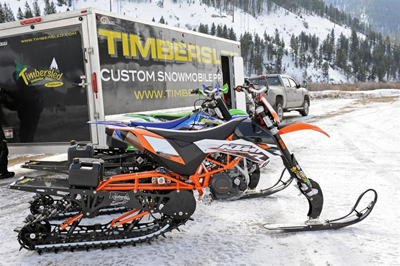 10
10  11
11  12
12
 15
157 Facts You Need to Know
| |
July 10, 2014 |
|
| 7 Facts You Need to Know in Order to Address the Next Wilderness Proposal Involving Your Riding Area.
By Scott Jones, Esq – NOHVCC public lands team lead. Wilderness proposals from various advocacy groups frequently assert that there are numerous benefits resulting from the addition of public lands to the Wilderness system. The US Forest Service has released extensive new research contradicting these assertions. Often discussions with our elected officials take a far more favorable turn for multiple use recreation, when the officials realize the benefit of Wilderness accrues to a very small portion of the public users and negatively impacts many important issues that are being faced by the USFS throughout the country. This new research includes conclusions that: 1. There is no need for additional Wilderness for recreational usage. 20% of USFS trails are in Wilderness areas1 and these areas receive only 4% of all visitor days to USFS lands.2 Routes in Wilderness areas are difficult and exceptionally expensive to maintain due to strict management limitations.3 Teams of horses and mules can move large amounts of materials but are not cost effective when compared to a pick-up truck, as the maintenance equipment cannot be left on the mules overnight. 2. The Government Accountability Office recently identified that motorized users are the only ones who pay to play on USFS trails and even with this funding only 25% of all routes are financially sustainable due to high percentages of routes in Wilderness.4 If motorized funding is not available for management of dispersed recreational opportunities, the resources available to maintain any trail greatly diminish and possible impacts expand. 3. The true economic driver for local economies is multiple use recreation on public lands. USFS comparisons of user group spending profiles made as part of the National Visitor Use Monitoring process estimate the motorized user spends 2-3 times the amount of money spent by non-motorized users.5 This compounds the possibility of negative economic impacts to local communities from significantly lower levels of visitation after Wilderness designations. 4. Many Wilderness proposals erroneously rely on the newly released Outdoor Industry Association Report that concluded that $646 billion is annually spent on outdoor recreation. Wilderness proposals frequently assert this was the result of quiet use recreation. This is simply incorrect as the 2012 OIA study included motorized usage in their analysis.6 Previously versions of the OIA study attempted to only include non-motorized usage. 5. A recent USFS report to Senator Udall specifically stated that Wilderness areas are a significant factor contributing to poor forest health and the outbreak of mountain pine beetle throughout the western US.7 This position has been repeatedly stated by Colorado State Forest Service, who has found management restrictions in Wilderness Areas have caused significant outbreaks of Spruce Beetle infestations.8 USFS guidelines for management and protection of watersheds identify the critical need for active management of watersheds to insure water quality.9 This management is impossible in a Wilderness area. Limited forest management is specifically identified as a major factor negatively impacting endangered species such as the Canadian lynx.10 6. The critical need for motorized access to multiple use recreation was recently identified by the National Shooting Sports Foundation which found that a lack of motorized access was the largest single barrier to those wanting to hunt and fish.11 A lack of multiple use access is also indentified as a significant limitation to herd management and herd health.12 7. Agency inventories and determinations on possible designations of Roadless Areas are not management decisions but are rather inventories of characteristics of that area. Roadless areas are still governed by multiple use management and changes to management require NEPA analysis or Congressional action. There are significant limitations on the scope of the Roadless Rule as it only applies to new road construction or major reconstructions. Trails, even those over 50 inches wide, are not impacted by the Roadless Rule. Many areas that are involved in citizen Wilderness proposals have been inventoried and found to be unsuitable for Roadless designation and this should weigh heavily against any suitability for Wilderness designation. The next time you are faced with a new Wilderness Proposal that is impacting your riding area, please let your elected officials know you don’t support the proposal and substantively provide them with copies of the reports identified above. Good science does not support Wilderness designations, and makes a balanced discussion of the issue far more achievable. 1 See, United States Government Accountability Office Report GAO-13-618; Forest Service Trails; Long- and Short-Term Improvements Could Reduce Maintenance Backlog and Enhance System Sustainability; June 2013 at pg 30. Complete report is available here: www.gao.gov/assets/660/655555.pdf
|
||
|
|
||
2013 Ride With Respect Year in Review
Reprinted with permission
Ride with Respect Year in Review 2013
www.ridewithrespect.org
Winter set in early around Moab. It’s a good thing that RwR was so active during the first half of 2013. Our nonprofit was busy conserving shared-use trails and their surroundings.
In fact, RwR’s work has nearly outpaced its budget. If you haven’t already contributed time or money this year, please consider sending a check to Ride with Respect, 1310 Murphy Lane, Moab UT 84532. (As a 501c3 organization, all donations are tax-deductible.)
Many employers will effectively double your donation through their matching-gift programs. Particularly in larger companies, human-resources departments will typically instruct you to make the donation and then submit a form requesting the match. Next the company will contact RwR to verify receipt of your donation, and finally they’ll match it dollar for dollar!
RwR’s productivity is due to many individual contributors as well as Grand County, Utah State Parks, Colorado Trails Preservation Alliance, and the Yamaha OHV Access Initiative.These four organizations have supported us for many years, so we cannot thank them enough.
To highlight our recent accomplishments, let’s go from northwest to southeast.
DEAD COW – In case you’re wondering, Dead Cow is the name of an off-highway vehicle (OHV) trail near the town of Green River. It’s a tough one to manage, being important recreationally and ecologically. Over the years, Dead Cow and another odd-sounding trail, The Tubes, have become quite braided. Fortunately the Bureau Of Land Management (BLM) supplied RwR with a few thousand pounds worth of sign and fence supplies. We spent a few hundred hours marking the trail and blocking the braids (see attached photo). So far this mitigation is working to restore some vegetation and preserve access along the main route.
ENDURO LOOP – Also up toward Green River, a motorized single track traverses three steep hills. They provided great challenge, but were eroding into nearly-impassable ledges. Rerouting to a more gradual line will be less challenging but longer and, most importantly, durable. RwR spent five-hundred hours constructing the new lines(see attached photo), and the BLM matched those hours!RwR volunteer groups included Northern Colorado Trail Riders and Bookcliff Rattlers Motorcycle Club.BLM volunteer groups included a local Boy Scout troop and University of Virginia service project, plus the Utah Conservation Corps. By springtime, we’ll close the old lines and open up the new ones.
SOVEREIGN TRAIL – You may recall that last year RwR marked a 4WD trail at the north end of Sovereign Trail System. Originally to be named after Brody Young, the State Parks ranger decided on Fallen Peace Officer Trail. That name set the stage for a memorial event this past spring. The Utah Peace Officers Association(UPOA)got help from RwR, local government, the Utah State Parks OHV Advisory Council, and the Utah division of Forestry, Fire, & State Land: Read Moab Sun News Article»
That day, rain made the trail muddy, and most participants were smart enough to postpone the ride. At the ceremony, a few hundred folks came with rain coats and left with a profound appreciation for our public servants in law enforcement: Watch YouTube Video here»
Let’s hope that next year’s event, on April 5th, will be equally moving and a bit more sunny.
LA SAL MOUNTAINS – Over the last several years, RwR has developed a trail system in the eastern La Sals with the Utah School & Institutional Trust Lands Administration. This year, our partnership was the subject of a couple television segments:
AYL segment – SITLA swap Trailhead – watch here»
AYL segment – La Salle Mountains Travel – watch here»
In Utah, At Your Leisure airs every Sunday morning at 9:00, right after a show on local government, The County Seat. In other states, check your television listing, or watch episodes online:
http://ayltv.com/index.html
http://thecountyseat.tv/
RwR didn’t finish installing more OHV cattle guards, but we look forward to working with SITLA as well ast he U.S. Forest Service in the La Sals next summer.
EDUCATION – A broad base of tourism has sustained Moab’s economy for the last couple of decades. The crowds can create certain problems of success, such as use conflicts and loving the land to death. Visitors don’t automatically know to stay on the trail and yield for others. Fortunately there are outlets willing to spread the word. Statewide, the RIDE ON Utah campaign is being developed by Tread Lightly: Read more here»
This past year RwR worked with the Moab Area Travel Council to introduce opportunities for motorcycle trail riding: discovermoab.com/motorcycle_moab.htm
We also worked with the Moab Times-Independent to produce OHV-trail reviews in seven editions of Explore Moab (all months except August): Read them all here»
For an electronic version of the main publication, you can subscribe here» Of course a paper version is also available here»
Both the Moab T-I and the Moab Area Travel Council generously provided forums to promote a trail ethic.
BICYCLING – Most editions of Explore Moab also feature an article from Trail Mix, which is Grand County’s committee on non-motorized trails (watch video here») Developing new trails for bicycling, hiking, and equestrian use takes some pressure off of the motorized trails. In the past few years, Trail Mix has constructed about seventy-five miles of mountain-bike trails, plus paved paths. They aim to double thatmileage, and maintain the routes. This halfway point provides a moment to thank Trail Mix. The group includes outstanding volunteers like Sandy and Geoff Freethey, partners like Moab Trails Alliance, and others like the new local chapter of IMBA: http://moabmba.com/ Their combined efforts are diversifying the area’s recreation opportunities and improving the general quality of life.
RECOGNITION – Christmas came early for Clif at the annual conference of the National Off-Highway Vehicle Conservation Council (NOHVCC). The group awarded me with State Partner of the Year (read article here»)
It’s gratifying to be a small part of NOHVCC’s big accomplishments. The group bridges gaps between OHV advocates and land managers. For examples, you can check out many presentations from the conference here»
Currently the partner position is open in a handful of states: nohvcc.org/Contacts/PartnerContact
If you know of OHV leaders in those states, encourage them to apply.
MORE RECOGNITION -Likewise Dale got some press this year: Moab Times story The article highlights many of his accomplishments to date. Regarding RwR, it mentions his transition from executive director to chairman of the board. Although he won’t be doing the daily tasks of operation, Dale is committed to helping guide and grow the organization. Already we’ve come a long way, and had nearly a thousand people contribute to responsible recreation through RwR (see attached letter). It all started when Dale got an attorney to write the articles of incorporation, and got friends to restore areas like Tusher Tunnel. With hindsight, these seem like simple steps. But at the time, the horizon was dusty. Dale squinted his eyes, gripped the tank, and twisted the throttle. For that leap of faith, I am grateful.
Happy Holidays!
Clif Koontz,
executive director
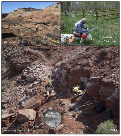
I feel compelled to go back a few years before RWR as it is our ten year anniversary. Way back when I was one of those California guys, I always felt that all of us who use public land should be involved in the the processes that make our use possible. I can remember back in 1963 when the US Forest Service made it mandatory to have a spark arrestor. I went to a meeting of one of the local MC clubs. A forest ranger was a special speaker. It was this guys mission to make sure that everyone riding a Moto in US forests had a sparkarestor mounted on his or her Moto. I sat there in my seat and tried to think of a single instance where carbon from a pipe or even exhaust flames from a pipe ever have been actually been the cause of a forest fire or a brush fire. Most of us ran Two strokes that ran so rich that the oil would spit out of the pipe not carbon or flame. The only time I ever saw a moto start a fire is when it go laid over in dry grass and the outside of the pipe mixed with gas or just the heat of the pipe started a little fire. To make things worse, the Forest ranger told me that I had to have a forest service approved arrestor, with a special stamp on it. Now that was enough to get me really riled up! Here was some guy telling me that I had to go (PURCHASE) something that I could make for darned near nothing, with no option to go into a forest service office and get mine checked out. This was my first real first hand experience with my own Government making a ruling that made no sense in a scientific manner or even a practical manner. The law was passed purely to pacify folks that did not have actual field experience in the cause of fires, but felt that the stuff coming out of the pipe had to be the culprit.
For years I felt guilty for not taking part in land use and trail development, always with the thought of how I could get something going that made sense to the natural environment and to the general public. As humans we tend to make most our decisions on something we have heard ,or just a knee-jerk reaction to a situation that comes up. In forming Ride With Respect, I decided to surround myself with folks that have an education in the different facets of land use. Our board is made up of folks that know way more about the science than I will ever know, but because of them we have made a very successful team. Do some of us go over the edge once in a while YES!!!, but the process as a whole is working very good.
With very little money Ride With Respect has been successful A major influence in the latest resource plans of the State of Utah, US forest service, and the BLM in our area. Fact is, we have been a conduit for many of the land use organizations and clubs for all the time we have been assembled as a group. Without the help of these groups, Ride With Respect would have not been able to get anything at all done on the ground. I believe that we have changed the perception of motorcyclists in general for the better, especially around Moab, to a point where we (riders) are looked upon as friends, not someone that is just out to scare folks and make noise.
In ten years Ride With Respect has helped educate folks on land use, not only by talking at meetings, but, much better by the way we act and execute our actions. The government land managers are now giving RWR many opportunities to build more and better sustainable trails.
TEN years; RWR/ Bookcliff Rattlers Thompson Trail
Moab BLM RMP
Sovereign trail system
Behind the rocks
State forest single track
New re-route Robertson Pasture Abjo Mountains
Re-route Red Ledges
Re-route endro loop
Many field days with Grand County residents, and other friends
As I step down in order to get some Hot Rods / old bikes built,— and do some more exploring Thanks to all of you great folks that have been with us. The ball is now on a roll, o’l Dale will still be out there clearing trail, but no more phone calls and meetings! Thanks to everyone once more, It has been a great ride, come try to catch me some day!
Dale L. Parriott
A Lesson Learned for All – Note from Jeff Slavens
| June 28, 2914 | ||
| Jeff recently shared this message in his weekly Slavens Racing email:
Last week was a rough one for dirt bikers in Colorado, both residents and visitors. Several guys from out of state came to southwest Colorado for what I’m sure was expected to be the experience of a lifetime, and that it was. It just wasn’t exactly the experience they were expecting or wanting. Not knowing the laws of the land, the guys went to a high elevation area that was not yet open for riding because the trails were full of downfall trees and snow drifts. They rode around the downfall trees (not easy to do because of the steep terrain) and snow drifts and committed what locals consider a Cardinal sin, they cut the switchbacks. All of this did significant damage to the fragile high alpine tundra and gave ammunition to the tree huggers during a time when that area is in its 3rd round of litigation to keep the trails open. Some local dirt biker trail advocates caught them in the act and the conversation began. The first conversation did not go well. I’m told (I was not there) that the visitors position was “we drove a long ways to get here and we’re going to ride no matter what”. The locals were outraged, trail advocates from around the western U.S. were angry, tempers flared, emotions ran high, innuendos, and accusations were coming from all involved, me included. The lynch mob was looking for a rope and a tall tree. After a restless night, local Matt A. manned up, drove to where they were staying, and confronted the 8 guys allegedly involved. (To give a little background, Matt has lived in the area for a long time, taken care of the trails, and been involved in the legal battles). The conversation went much better this time and the guys asked what they could do to reconcile their actions. Matt reluctantly handed them a chainsaw and asked them to get to the dirty work of fixing the damage and cutting the downfall trees. Long story short, the guys manned up, stood by their word, and worked all day repairing the damage and cutting downfall trees. In their defense, there were no closed signs posted by the USFS, there was no easily accessible information on the internet, and in their part of the country there is little snow and riding around trees is acceptable, so I’m told. Bottom line is, these guys have been verbally beaten up by all involved and deserve a break. These are our dirt bike brethren that made an honest mistake and have paid their dues. Hopefully they will become trail advocates, join the local trail cub, and donate to our legal defense fund. What have we learned? Bottom line is, Colorado trails (and other mountainous states) are usually not ready to be ridden each year until around the 4th of July. It takes until then for the snow to melt and the locals to clear the downfall. It is a federal offense to go off trail in Colorado and if caught you will have to appear in front of a federal judge. Tread lightly, stay on the trail and leave the trails better than you found them. Please join the trail club that takes care of the trails in the area you plan to ride. For me that is about every club in Colorado. If you want trails in the future, donate to the group that fights our battles in Colorado, Colorado Trails Preservation Alliance. Regards, NOTE: I’m not naming the area because it does NOT need more internet exposure and the resulting trail damaging traffic. Please do NOT post ride reports or videos about your trails.
|
||
|
|
||
Canyon Lakes Timber Sale Comments
| |
June 16, 2014 |
|
|
Canyon Lakes Ranger District RE: Cherokee Park Fuels Treatment Dear Mr. Clark: Please accept this correspondence as the comments of the above noted Organizations regarding the Cherokee Park Fuels Treatment proposal. The Organizations vigorously support the removal/thinning of dead trees in the planning area and management of the area for the long term sustainability of forest health. The Organizations believe the wildfire and subsequent flooding history on the Canyon Lakes RD provides first hand experiences and compelling evidence for the need for active forest management but the Organizations do have signfiicant concerns with the Proposal. Prior to addressing the specifics of these concerns, a brief summary of the Organizations is warranted. COHVCO is a grassroots advocacy organization of approximately 2,500 members seeking to represent, assist, educate, and empower all OHV recreationists in the protection and promotion of off-highway motorized recreation throughout Colorado. COHVCO is an environmental organization that advocates and promotes the responsible use and conservation of our public lands and natural resources to preserve their aesthetic and recreational qualities for future generations. TPA is a 100 percent volunteer organization whose intention is to be a viable partner, working with the United States Forest Service (USFS) and the Bureau of Land Management (BLM) to preserve the sport of trail riding. The TPA acts as an advocate of the sport and takes the necessary action to insure that the USFS and BLM allocate to trail riding a fair and equitable percentage of access to public lands. For the purposes of these comments, COHVCO and TPA will be referred to as the Organizations. 1. The Collaborative letter does not accurately reflect the project scope, which will impair public comment. The Organizations are concerned regarding the narrow scope of project identification in the April 28 scoping letter, where the project is clearly identified as reducing fuels hazards project to improve forest health. This narrow scope will directly impact the involvement of the public, or lack thereof, in the project. This is very concerning as while forestry is a significant portion of the project, travel management is also a significant component of the project as reflected by the development of the Travel Analysis Report. The scope of this project simply is not reflected in the scoping summary letter and project name despite possible closures in the area being approximately 50% of routes. The Organizations are aware that travel management is specifically addressed in the project overview power point for the May 15 meeting, but are concerned that many trail and route users would not attend the meeting to be able to comment on the proposal under the erroneous belief that the project was only a timber sale and that any route closures would only be temporary in nature. This is simply is not the case. The Organizations believe obtaining this input is a critical component to developing a quality planning product and developing significant public support for fuels projects moving forward and avoiding closures of routes that are a significant benefit to private lands. 2a. USFS Budget constraints cannot be addressed with multiple use closures alone. The Organizations would like to be able to support all trails proposals from all user groups but this simply is not realistic given agency budgets and the unwillingness of many user groups to self tax in a manner similar to the programs that have been in place as a result of the motorize users self taxing a long time ago. This failure to provide a funding stream for site development has impaired these user groups ability to partner in development of projects such as the project now sought to be developed. The Organizations believe that these issues must be addressed at both the project level, district level and forest level to obtain a meaningful resolution of these issues. Creating numerous small projects to address multiple use access in a piecemeal p[process will never be effective and must be avoided. Last year the Government Accountability Office concluded that only 20% of the US Forest Service trail network was financially sustainable. This sounds ominous for trails, but this conclusion may not be all that applicable to multiple use trails given the vigorous OHV registration programs that many states have developed to fund trails on federal lands. The Organizations believe that all federal land managers must understand the scope of this study in order to avoid unnecessary closures and allow actual resolution of this issue. Understanding the scope of the study is critical to remedying this management question and protecting multiple usage. The GAO study addressed all trails, including non-motorized trails in designated Wilderness, which the GAO study found accounts for 20% of the USFS trail network. While the GAO found Wilderness trails account for 20% of all trail mileage, Wilderness visitation accounts for only 3.3% of visitor days to USFS lands nationally, which results in a significant imbalance in supply and demand for these opportunities. While there is a significant oversupply of these opportunities, maintaining this oversupply is expensive due to management limitations on methods of maintenance that can be employed. Trail maintenance of any kind is always easier, cheaper and safer when mechanized devices are used and these are prohibited in Wilderness areas. Throughout the western United States the motorized community has adopted voluntary registration programs to help off-set the costs of maintaining multiple use routes, which is addressed in the GAO report. This funding supplement is often lost in overly brief summaries of the GAO report but is a critical point in resolving this management question. Often these voluntary registration programs provide significantly more money for trail maintenance in a steady and predictable manner for land managers than the Forest Service has available internally. There is no similar program for the maintenance of Wilderness trails. Often any state funding for maintenance of Wilderness trails is very limited and highly fluctuating and there is only so much maintenance that can be performed by volunteers. This makes supporting the current oversupply of Wilderness routes very difficult to justify. Resolving the USFS funding issues for trails is going to be a significant issue moving forward and is one that cannot be remedied by closing the trails that are sought after by most people and at least partially funded by the users, such as those in the proposal area. Resolution of this management issue should start with closing Wilderness trails that are not used and are exceptionally expensive to maintain and in bad need of maintenance. Closing multiple use routes will never resolve the USFS funding issues and would impact large numbers of users for the benefit of a severely underutilized resource. 2b. Funding sources for multiple use routes are available. The Organizations are strong partners with the CPW trails grants program, which annually grants more than $4,000,000 in funding to public lands management in Colorado. The Organizations are aware that several grants have been awarded to the Clear Creek Ranger District over the last several years such as the Kelly Flats Grant awarded previously. However the Clear Creek Ranger District has not applied for an OHV good management crew from the CPW program. These grants allow for a streamlined application process to provide consistent annual funding for seasonal employees dedicated to multiple use trails in the Ranger District. Many of the Ranger Districts and BLM Field Offices have found these teams to be invaluable resources for the maintenance of multiple use trails, and have found these teams to be invaluable in avoiding large scale trail closures in attempts to address financial shortfalls. The Organizations strongly encourage the Clear Lake RD to work towards obtaining such a team and would be willing to assist or facilitate in this process in any manner needed. A summary of the most recent OHV grant awards has been enclosed with these comments for your reference. 2c. Alternatives for travel management of some routes must be addressed. The Organizations believe that most of the routes in the proposal area to be closed are identified as Forest Service Roads. The Organizations would like to explore possible alteration of these routes to Forest Service Trails, and possibly restricting usage to 50 inches or under or 30 inches and under. These designations would significantly reduce maintenance costs for these routes and maintain these routes for multiple use recreation. The Organizations are aware of numerous trail width restrictors that are being unused in other ranger districts and would be able to assist with obtaining these items. While these routes may not be extensive, these routes could provide a highly valued recreational experience for users at a minimal cost. As noted in other portions of these comments, these opportunities are very limited on the Front Range due to the heavy impacts of flooding on all public lands. 3. Project Timing The Organizations believe the wildfire and subsequent flooding history on the Canyon Lakes RD provides first hand experiences and compelling evidence for the need for active forest management. While these impacts are compelling, the Organizations vigorously assert that these impacts are not limited to the Canyon Lakes District as much of the Arapahoe/Roosevelt NF has been heavily impacted by flooding last year. This flooding has heavily impacted many of the easily accessible areas and routes along the northern front range, such as the Lefthand Canyon area and Storm mountain area, and the time frame for restoration of these opportunities is unclear at best. These challenges make the recreational opportunities provided in the Cherokee Park area exceptionally highly valued in the short term, and the Organizations have to believe that Canyon Lakes staff has already noted an increase in recreational visitation as a result of the area being one of the few accessible day use recreation areas remaining along the front range. The Organizations would request that the timing of forest thinning activities be coordinated to minimize any impacts to these limited recreational resources until such time as mitigation and restoration has occurred on other areas to allow recreational activity to resume. 4. Lynx management decisions are based on in accurate summaries of out of date management standards. The Organizations are very concerned that best available science and management standards have not been applied for the management of lynx habitat and linkage areas in the Travel Analysis Report (TAR), and as a result limited resources will be directed towards issues that can never be resolved with those funds. These concerns are based on the identification of high risk factors assigned to roads that may be in lynx corridors and habitat areas, while roads outside these habitat areas are a low risk factor.1 The Organizations are concerned regarding the basis for the allocation of risk in this decision matrix, even under the Southern Rockies Lynx Amendment, which provides: “Unlike high-speed highways, the types of roads managed by the Forest Service do not have the high speeds and high use levels that would create barriers to lynx movements or result in significant mortality risk. Roads may reduce lynx habitat by removing forest cover, but this constitutes a minor amount of habitat. Along less-traveled roads where roadside vegetation provides good hare habitat, sometimes lynx use the roadbeds for travel and foraging (Koehler and Brittell 1990). Research on the Okanogan NF in Washington showed that lynx neither preferred nor avoided forest roads, and the existing road density did not appear to affect lynx habitat selection (McKelvey et al. 2000). Available information suggests lynx do not avoid roads (Ruggiero et al. 2000) except at high traffic volumes (Apps 2000).” 2 The Organizations question if the SRLA reflects the heightened risks that are reflected in the decision matrix. The Organizations are even more concerned that the TAR relies on data that has been superseded the SRLA. The Organizations have been highly involved with the management of lynx in Colorado, and have been active participants in the Lynx Blueprint project and have been partners with the Colorado Snowmobile Assoc, who has been actively supporting lynx research both on the San Juan and White River National Forests. This research has specifically targeted the analysis of lynx utilizing areas where high levels of recreation are occurring and as such should be highly relevant to these issues. After reviewing the TAR, several critical issues were immediately apparent. The TAR relies on the Southern Rockies Lynx Amendment (“SRLA”) for the management of many issues, but the SRLA was recently superseded by the 2013 Lynx Conservation Assessment and Strategy, which made significant changes to the management of many issues. A complete copy of this document has been included with these comments for your reference. The Organizations are troubled that the decision matrix appears to conclude there is a negative relationship between motorized routes and lynx habitat. This could not be further from the truth, as in 2013 there were significant changes in national lynx management standards specifically regarding recreation including the following conclusions:
Failing to manage habitat areas to mitigate impacts of poor forest health issues, such as the spruce and mountain pine beetle, is a major concern in lynx habitat for a long duration.10 Clearly these new national management standards fall well short of creating any basis for implications that a properly managed road and trail network in lynx habitat will negatively impact that habitat. The Organizations are not asserting that there are negative implications to lynx habitat from the forest thinning, as the 2013 LCAS concludes there are significant benefits. A complete review of up to date information on this issue would have referenced the benefit that active forest management and timber sales involving roads would provide to the lynx rather than continuing the erroneous belief that lynx habitat and recreational usage are mutually exclusive. While the Organizations are unable to apply the decision matrix to particular routes, the Organizations vigorously assert that any closures that were to be addressed in Cherokee Park thinning plan must be re-reviewed under a new decision matrix in order to apply best available science and avoid management to avoid negative impacts to lynx habitat that are not supported by best available science. 5. Seasonal closures are highly effective for the protection of Calving and Lambing areas. The Organizations have been vigorous supporters of mitigation efforts that avoid possible impacts to wildlife from trail usage. The Organization’s have found that seasonal closures of calving and birthing areas have been highly effective in protecting recreational access to areas and use of the area for birthing and calving. The Organizations continue to support this management but have to question the basis for any seasonal closures of routes or permanent closures of routes for the protection of calving and birthing areas after a review of CPW information on calving and birthing areas in the project area. The Cherokee Park fuels Plan again assigns higher risk factors to routes in elk calving areas and lower risk to routes outside calving areas. The CPW mapping of calving and birthing areas for elk generally in the planning area reveals there are no calving and birthing areas within the project area. The closest calving area is generally adjacent to the Boulder Ridge area, which is well to the northwest of the project areas. The CPW mapping of reproduction areas reflects these boundaries as follows:
CPW Elk Production areas 11 The Organizations are opposed to any elevated risk factors in the route decision matrix, and resulting route closures as CPW information reveals that there is no calving and birthing areas for elk in the fuels treatment area. 6. Conclusion The Organizations commend the Canyon Lakes RD for undertaking the fuels treatment project, as the Organizations have been long time and vigorous supporters of the active management of forest resources. Fuels treatment is a critical component of this active management and critical to the ongoing stability of the forest resources. The Organizations are concerned that public input on routes in the planning area will be impacted by the limited scope of the notice and that there are funding options available for the maintenance of routes in the planning area that have not been utilized. The Organizations are very concerned with USFS budget situations for trails, and are also concerned that these issues extend well beyond any resolution in the project area. The budget issues can only be resolved by addressing recreational access to areas that are badly underutilized and exceptionally expensive to maintain, such as Wilderness trails. The Organizations believe that providing resources to the largest number of public users must be the priority. The Organizations respectfully request to be included in any further proceedings relative to this project. Please feel free to contact Scott Jones, Esq via phone at 518-281-5810 or via email at scott.jones46@yahoo if you should have any questions regarding these comments. Sincerely, Scott Jones, Esq.
D.E. Riggle
1 See, Travel Analysis Report at pg 30. 2 Id at pg 16. 3 See, Interagency Lynx Biology Team. 2013. Canada lynx conservation assessment and strategy. 3rd edition. USDA Forest Service, USDI Fish and Wildlife Service, USDI Bureau of Land Management, and USDI National Park Service. Forest Service Publication R1-13-19, Missoula, MT. 128 pp. at pg 94. Hereinafter referred to as the 2013 LCAS. 4 2013 LCAS at pg 83. 5 2013 LCAS at pg 95. 6 2013 LCAS at pg 84. 7 2013 LCAS at pg 83. 8 2013 LCAS at pg 26. 9 2013 LCAS at pg 94. 10 2013 LCAS at pg 91. 11 Boundaries are based on Google Maps of these factors available for purchase from hunting GPS maps at www.huntinggpsmaps.com
|
||
|
|
||
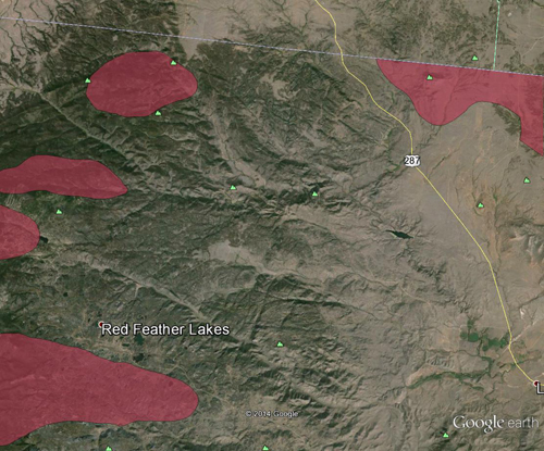
CPW Rio Blanco County Trails Master Plan
| |
May 19, 2014 |
|
|
COLORADO PARKS & WILDLIFE May 19,2014 Drew Stoll Drew, Anytime there are plans to increase human activities in a specific area, there are likely to be negative impacts to various wildlife species. Recreation impacts to wildlife can occur at the individual, population or community level. Quantifying and qualifying these specific impacts within the project area will be difficult without knowing the exact time and extent of the increased activity. However, it is realistic to expect there will be impacts. CPW respectfully asks Rio Blanco County to balance the extent and intensity of trail development/promotion with the long-term, sustainable wildlife re ources that already exist in the County. CPW’s concerns, given the information that we are aware of at this time, include economic impacts to hunting and fishing activities, wildlife and wildlife habitats, and ability to provide on-going assistance and input on planning and development plans and development activities. Economic Impacts Statewide Economic Impacts of Hunting and Fishing in 2007 Note: Measured in 2007 dollars. 1. Trip and equipment expenditures and CPW expenditures in support of these activities. 2. Direct expenditures plus secondary spending by businesses and households (multiplier effects). 3. Includes job creation from direct and secondary expenditures. Source: BBC Research & Consulting, based on data from CPW and USFWS 2006 national survey. Hunting and fishing recreational activities are a sustainable annual source of economic benefit for Rio Blanco County only if wildlife populations are maintained at or near CPW objective levels and quality hunting and fishing opportunities continue to exist. Extensive trail development and intensive use may reduce population levels of big game, diminish hunt quality, reduce hunting and fishing recreational opportunities in the affected area of the county, and decrease sustainable revenues from these activities. Rio Blanco County (RBC) has some of the highest big game hunter participation in Western Colorado. Large mule deer and elk populations exist within RBC. Any impacts associated with increased Off Highway Vehicle (OHV) activities on public lands could reduce the hunter participation rate and thus reduce revenues within the County. Direct and indirect expenditures for Rio Blanco County are summarized in the following table.
Wildlife and Wildlife Habitat Impacts CPW maintains an up-to-date set of data and spatial reference -Species Activity Maps (SAM). SAMs are updated every four years, for 32 game and non game species. The most recent update for Rio Blanco County was completed in 201012011. CPW used SAMs to identify species specific seasonal habitats that lie within the County. Using SAM CPW identified the following species and habitats in the County: mule deer, elk, pronghorn antelope, greater sage-grouse, sharp-tailed grouse, lynx, raptors, black bear, moose, cutthroat trout, native non-salmonid fish species, black footed ferret, boreal toads, and riparian habitats. Bat species and northern leopard frog were also identified in this review. Impacts to Wildlife Big game species can become sensitive to human disturbance. Studies have demonstrated decreased reproductive success in female elk, increases in stress hormones, and decreased opportunities for animals to feed and rest (Naylor et aI. 2009, Phillips and Alldredge 2000, Taylor and Knight 2003). With the increased energy development, continued human development and loss of habitat within RBC, the available quality wildlife habitat is dwindling. Habitat fragmentation Lyon (1983) developed a general model of habitat effectiveness for elk that modeled percent habitat effectiveness as a function of road density. Declines in habitat effectiveness were non-linear, indicating that much of the loss of habitat effectiveness occurred in the first 2.6 mile/miles2 of increasing road densities. Edge and Marcum (1985) reported that elk leave a 500-1000 m buffer zone around logging roads when traffic is high (at at rate of a few transits per day), but not at other times. Similar observations have been made for deer (Dorance et al 1975; Singer and Beattie 1986), and coyotes (Gese et al. 1989). Wisdom et al. 2004 reported that elk flight response to hikers had little effect when hikers were beyond 550 yards (500 m). By contrast, higher probabilities of elk flight continue beyond 820 yards (750 m) for horseback riders and 1650 yards (1,500 m) from mountain bide and A TV riders. In contrast, mule deer respond with fine-scale changes in habitat use, rather than substantial increases in movement rates and flight responses. For example, it is possible that mule deer may respond to an off-road activity by seeking dense cover, rather than running from the activity. If mule deer are spending more time in dense cover, in reaction to any of the off-road activities, this could result in reduced foraging opportunities, and a subsequent reduction in opportunities to put on fat reserves during summer that are needed for winter survival (Wisdom et al. 2004). Greater Sage-Grouse With the potential listing of these birds as threatened or endangered by the US Fish and Wildlife Service (USFWS) anything that could potentially impact these birds needs to be close scrutinized. The Piceance Basin has a long existing GrSG population. They are spread across several areas within the Piceance Basin and utilize various areas for leking, nesting, brood rearing, wintering and other life cycle activities. Proposing any additional public use in some of the critical areas at seasonal times could cause negative impact and listing implications. Careful consideration needs to be made to protect this species. CPW can provide maps and information for GrSG for consideration in this planning process. The need to maintain extensive sagebrush habitat over large areas around leks for sage grouse breeding populations to persist has been clearly stated by all major reviews of sage-grouse habitat requirements (Schroeder et al. 1999; Connelly et al. 2000, 2004; Crawford et al. 2004; Rowland 2004). Because nest success and chick survival both contribute substantially to population growth in sage-grouse (CDOW 2008, Walker 2008), protecting breeding, nesting and brood-rearing females and breeding males is crucial for maintaining breeding populations. Aquatic impacts Providing riparian buffers of sufficient width protects and improves water quality by intercepting non-point source pollutants in surface and shallow subsurface water flow (e.g., Lowrance et aI., 1984; Castelle et aI., 1994). Healthy riparian buffer strips are widely recognized for their ability to perform a variety of functions other than water quality including stabilization of stream channels, providing erosion control by regulating sediment storage, transport, and distribution; providing organic matter (e.g., leaves and large woody debris) that is critical for aquatic organisms; serving as nutrient sinks for the surrounding watershed; providing water temperature control through shading; reducing flood peaks; and serving as key recharge points for renewing groundwater supplies (DeBano and Schmidt 1989; O’Laughlin and Belt 1995). Buffer strips also provide habitat for a large variety of plant and animal species and have become a popular tool in efforts to mitigate fragmentation by increasing connectivity of isolated habitat patches and conserving biodiversity (Rosenberg et aI., 1997). Wildlife habitat and movement corridors in riparian zones are also an important consideration. Appropriate designs for species conservation depend on several factors, including type of stream and taxon of concern (Spackman and Hughes 1995). Recommended widths for ecological concerns in buffer strips typically are much wider than those recommended for water quality concerns (Fischer 1999; Fischer et aI., 1999), often exceeding 100 meters in width. These recommendations usually apply to either side of the channel in larger river systems and to total width along smaller streams where the canopy is continuous across the channel. Management for long, continuous buffer strips rather than fragments of greater width should also be an important consideration. Continuous buffers are more effective at moderating stream temperatures, reducing gaps in protection from non-point source pollution, and providing better habitat and movement corridors for wildlife. There are many other important species (which CPW has not specifically brought up for discussion) that require avoidance and minimization actions as Rio Blanco County plans, designs, and implements this county-wide trail network. CPW realizes that many of the proposed roads are currently open for public travel. CPW also recognizes that big game hunters also use Off Highway Vehicles (OHV) during the hunting seasons. Staff has observed big game species change distribution over the years due to this increase in motorized vehicle use. This change in distribution is of concern to staff and will require CPW staff to include the change in future management actions. CPW staff is also concerned about the unintended issues that are likely to arise out of such an extensive project. CPW has concern about enforcement of additional motorized travel to help prevent pioneering or creating new roads and trails into more pristine and protected habitat. CPW, as an agency, does not have the personnel, finances, or commitment to be able to help regulate this increase in motorized activity. CPW participation in on-going assistance and input on planning and development plans and development activities. CPW staff; DWMs, Biologists, and Area Managers -have a well-developed knowledge of the County and specific areaslhabitats depicted on the preliminary plan map and are prepared to assist as needed or requested. CPW is very much concerned about the extensive nature of this project. CPW asks that Rio Blanco County incorporate as much avoidance, minimization and mitigation measures as possible in this trail planning, design, and implementation project. The wide-ranging nature of the project will take extensive efforts to balance the known, wildlife resources that the County currently depends on and the new (and unknown) recreation proposition. CPW recommends that the following concepts be include in the project.
CPW respectfully asks Rio Blanco County to balance the extent and intensity of trail development with the long-term, sustainable wildlife resources that currently exist in the County. CPW staff is available to support Rio Blanco County in their analysis of any of the individual routes with respect to wildlife and wildlife habitats. CPW appreciates the opportunity to share our thoughts on this important project and we are available to answer any questions or assist with clarification of concerns. Please do not hesitate to contact me at 970-878-6061. Sincerely, cc. Ron Velarde, NW Regional Manager Literature
|
||
|
|
||
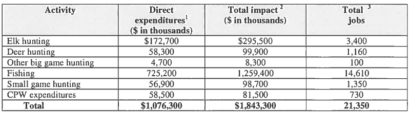
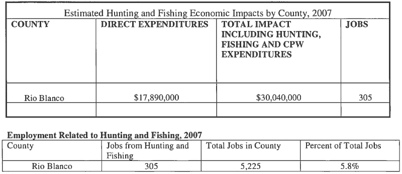
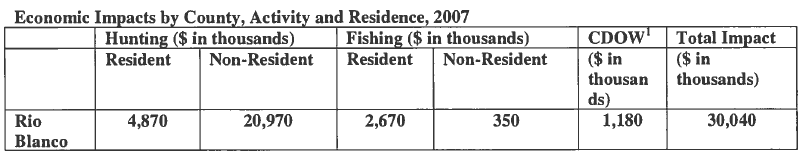
Issues at a Glance
| |
May 5, 2014 |
|
| ISSUES AT A GLANCE
This section is designed to highlight various issues where COHVCO,TPA, CSA and their partners and local clubs are defending public access to public lands. This glance at the issues is not an exhaustive list of the issues we are involved with, but rather is highlighting issues of statewide importance or interest. RECENT WINS The EPA recently decided to continue current ethanol production standards for usage in motor fuels meaning that current E10 limits will remain for another year. EPA testing indicates that small engines not designed for E15 fail almost immediately when it is used as a motor fuel. In addition to the failure of the motor, damage that results from E15 being used is not covered by manufacturers warranties. The Organizations and their national partners are now heavily involved in efforts to obtain legislation that would effectively limit ethanol production to only amounts necessary to support current E10 levels and make the recent EPA findings final as a matter of law. 2. 143 miles of routes reopened to OHV usage on the Eagle/Holy Cross RD- NEW The Eagle/Holy Cross Ranger district recently signed a FONSI determination that allowed OHV usage of 143 miles of roads and trails that had been previously closed in the Travel Management Plan. This provided a lot of access for all recreational users and avoided restrictions that were tough to enforce and made little sense on the ground. 3. New Lynx management documents have been published that clearly state trail usage and snow compaction are not an issue in lynx habitat- NEW COHVCO, CSA and many other groups have been very concerned about the failure of many federal land managers to address recreational activity in lynx habitat with best available science, which has specifically concluded almost all recreational activity has no impact on lynx that might be in the area. Many land managers continued to manage based on out of date management documents, where there was theoretical concerns about recreational usage. Stakeholder concerns have resulted in the issuance of new management documents that avoids these types of issues in the future by clearly stating roads and trails in habitat are not a major factor for the lynx and that most snow compaction in the Southern Rockies is the result of natural processes rather than recreational usage. These documents clearly state that only major ski areas may impact lynx behavior and provide extensive analysis that weighs heavily against any claim of Wilderness areas being a benefit for the lynx. CSA,COHVCO and TPA have partnered to provide a copy of these documents to every office that currently has a draft plan being developed or are areas where lynx management has been an issue previously. 4. The US Fish and Wildlife Service recently determined there should be no changes in forest management as the result of a wolverine in the planning area. This planning initiative addresses the management of millions of acres throughout the western United States and all areas above 10k feet in Colorado. The Organizations have been heavily involved in stakeholder discussions with the US Fish and Wildlife Service and Colorado Parks and Wildlife regarding best available science for the management of the Wolverine. As a result of these stakeholder meetings, best available science was clearly reflected in the recent USFWS listing decision as the decision clearly stated there should be no management changes on public lands as a result of the Wolverine. This is a major win as modeled habitat for the Wolverine in Colorado was any areas over 10,000 ft. and at one point closures to motorized access were seen as necessary in all these areas. This determination was a major step forward in protecting motorized access from misguided wolverine management standards. 5. The proposed expansion of parking facilities on Rabbit Ears Pass is moving forward The Hahns Peak Bears Ears Ranger District has moved forward with scoping on several site specific proposals for the expansion of parking areas on the Rabbit Ears Pass area outside Steamboat Springs Colorado. Parking is very limited in the area for winter usage causing a wide range of management and safety issues for users. This limited parking also limits access for motorized usage of the area that is consistently identified as one of the best snowmobile locations in the western United States. This project has been vigorously supported by the local clubs who have brought a wide range of information and resources to the table to allow for resolution of this issue. 6. Dillon Ranger District allows construction of over 20 miles of new single track motorcycle trail outside Silverthorne The Dillon Ranger District on the White River National Forest issued a FONSI permitting the construction of 21 miles of new single track motorcycle trail outside Silverthorne Colorado. This decision is the result of years of work and partnership between the local club and agency personnel. This trail network will provide a motorized single track opportunity in an area where these opportunities area very limited currently. 7. COHVCO and partners succeeded in obtaining passage of legislation allowing the titling of off-highway and over the snow vehicles in the state of Colorado. This will provide proof of ownership for vehicles that can exceed $15,000 to purchase new and allow for better financing rates from dealers. The issuance of a title will also allow better tracking of stolen OHVs in the state and better rates for those that choose to finance their new purchases. This legislation will become effective in 2014. Our next step is to obtain use of some county roads with the creation of a voluntary license plate on OHVs. 8. COHVCO and partners were able to insure that fines were not increased for a variety of OHV related issues with the reauthorization of house bill 1069. There was heavy pressure from those opposed to OHV use to increase minimum fines sometimes by hundreds of dollars for a variety of non-resource related issues. As a result of COHVCO efforts these fines maintained consistency with other violations. 9. COHVCO and its partners obtained dismissal of the Rico/West Delores lawsuit seeking closure of grandfathered routes on any MVUM. LAWSUITS 1. BLM Kremmling Field Office RMP appealed. NEW The Organizations appealed the KFO RMP which sought to close approximately 40% of routes in the planning area. This plan tragically undervalued recreational usage, estimating that the average user only spends $16 per day, which directly conflicts with BLM conclusions made in Sage Grouse planning that the average recreational user spent $121.96 per day. This is highly relevant as all the KFO has been identified as Sage Grouse habitat. USFS conclusions for average spending, that were asserted to be relied on in the RMP development conclude average spending is between $50 and $61 per day. Hard to say that recreational usage was accurately balanced when recreational usage is so badly undervalued. In addition to the economic analysis issues, economics were not integrated into the planning process as total spending and total visitation to the KFO doubled between the draft and final versions of the RMP but the jobs that result from this activity were cut in half, which simply defies logic. KFO jobs estimates were completely irreconcilable with any other outside research. On numerous other issues best available science was simply overlooked in favor of the most restrictive standards available, most of which have been completely discredited. 2. BLM Colorado River Valley RMP appealed- NEW. The CRVO and KFO plans were originally developed as a single plan but the Colorado River Valley proposes to close approximately 50% of routes in the planning area. As a result the valuation of recreational usage issues noted in the KFO summary are also appealed in the CRVO appeal. In addition to the economic issues, mandatory closures around all cultural sites identified now and in the future were required in violation of federal laws requiring protection of only significant sites. Thousands of acres and 143 routes were lost as a direct result of these management standards. 3. San Juan National Forest plan appealed- updated. The SJ/TR Planning area is 1.8 million acres and preferred alternative increases designated areas unsuitable for motorized usage by 83%. Trails in the unsuitable area are subject to a presumption of closure in the future. This is the Forest Service component for the BLM Tres Rios Plan and as a result the TR appeal points are also applicable to this matter. In addition to the economic analysis issues, the USFS fails to accurately apply the Colorado Roadless Rule managing under a single standard very similar to the upper tier standard, when most of the SJ/TR areas were specifically found to be unsuitable for upper tier designation in the Colorado Roadless Rule proceedings. At no point is there any discussion of why closure of roadless areas is warranted or that motorized access is a protected characteristic of a roadless area or why the two standards of roadless areas were not reflected in the RMP. The RMP further applies a designation of suitable or unsuitable for motorized use to the entire forest. It is has been our experience that such black and white type designations do not work in recreation management as this is not a black and white issue. Rather most recreation occurs in the gray area between absolute standards, making application of such a standard arbitrary at best. Suitability boundaries are also based on the position that all wildlife habitat is unsuitable for motorized usage. This black and white suitability standard conflicts with numerous US Fish and Wildlife decisions that find endangered species habitat areas are suitable for motorized usage with the implementation of minimal restrictions. This decision also fails to address the recent Wolverine listing decision that found there should be no change in forest management in wolverine habitat and that Sage Grouse listing decisions have repeatedly determined that recreational usage of habitat areas is not an issue. In yet another troubling lack of analysis, the RMP repeatedly asserts that no trails would be closed due the RMP and all review will be done later as part of site specific review. At other points the plan states it will close 25 miles of trail. This is a problem by itself, which is compounded by the fact that no information or analysis is provided regarding where these trails are or why they are being closed. 4. Tres Rios BLM field office plan has been appealed. The Organizations recently submitted an administrative appeal of the Tres Rios (“TR”) Field Plan Resource Plan and are optimistic about reversing this decision. The appeal centered around the tragic undervaluation of recreation in the RMP. Often TR conclusions on user group spending were 10-15% of the conclusions identified in the research that was asserted to be the sole basis of the conclusions. Developed campers are asserted to spend $46.11 while the research indicates developed campers spend ranges from $217 to $300 per day. Winter motorized users were particularly hard hit in this erroneous analysis as cross country skiers and downhill skiers spend $208 per day while snowmobilers only $127 per day. These conclusions are asserted to be based on USFS work that concludes downhill skiers and snowmobilers spend similar amounts and cross country skiers spend 40% less than those amounts. It is simply impossible to reconcile these types of conflicting conclusions. In addition to undervaluing recreation, current management of numerous areas, including the Molas Pass Area were not accurately reflected in the RMP. While the Molas Pass area has never been closed to motorized usage, the RMP asserts it is currently closed and all alternatives assert the area is to remain closed. Hard to argue there is a hard look at a closure when the closure is not reflected. 5. Winter Wildlands Litigation This issue involves litigation in Idaho brought by the Winter Wildlands Alliance attempts to mandate winter travel management for all national forests, limit open riding areas and to invalidate the winter provisions of the travel management rule. Previous decisions from the Forest Service had ruled in favor of motorized users on this issue. WWA appealed the Forest Service decision to Federal Court in Idaho. The trial court ruled in favor of WWA and required winter travel management for all forests and invalidated the winter portions of the travel management rule. This decision is being appealed by the Idaho Snowmobile Association and its partners as the trial court decision is lacking factual and legal basis. CSA has been actively involved in administrative appeals prior to the Federal Court proceedings. As this litigation was brought in Idaho, CSA has partnered with the ISA to facilitate the defense of this matter. This partnership has resulted in several large donations being made by CSA to the Idaho legal defense fund and any resources necessary being available to our Idaho partners. This lawsuit was served on the Forest Service and Colorado Springs utilities by the Center for Biological Diversity and others regarding exclusion of trails in the vicinity of cutthroat trout habitat. This suit sought a blanket exclusion of trails from areas adjacent to streams with cutthroat trout. COHVCO and TPA have intervened and making sure the best resolution for motorized recreation is obtained. Terms of settlement have been reached that would permit new trails to be created in the area and close the habitat area to all threats. TPA and COHVCO are working to insure the closures are applied per the terms of the agreement with the submission of a notice of intent to sue if the terms of the settlement agreement are not complied with. 7. Pike /San Isabel MVUM challenge – The first suit was filed on January 31, 2011 by anti-access plaintiffs including The Wilderness Society, Quiet Use Coalition, Wildlands CPR, and Center for Native Ecosystems and Great Old Broads for Wilderness regarding the Pike and San Isabel Forests. COHVCO and TPA intervened with the Forest Service to defend this lawsuit, which could impact every MVUM that has grandfathered existing routes. These defense expenses are being born solely by Colorado OHV advocacy groups. This case seeks to remove any trails that predated NEPA and were grandfathered in the creation of PSI MVUMs. The exact impact of this suit is yet to be clarified but this suit could impact trails such as the Blanca Peak 4wd trail. This case is currently moving forward in the discovery phase of litigation. 8. Rico/West DeLores- A second suit involving grandfathered routes on an MVUM was filed regarding the Rico West Dolores/alpine triangle area of the San Juan Forest brought by Colorado Backcountry Hunters and Anglers seeking closure of 14 trails which have a long history of motorized travel. COHVCO, TPA, Blue Ribbon Coalition, the San Juan Trail Riders and the Public Access Preservation Association have intervened to defend this matter with the Forest Service. The complaint was dismissed by the trial court and access was maintained. The trial court’s decision has been appealed. Recreational usage issues and concerns. 1. Hermosa Watershed Legislation – NEW The Organizations have been heavily involved in the Hermosa Watershed Legislation with Rep. Tipton and Senator Bennett’s Office and are optimistic it will be passed this session. This Legislation would release a wilderness study area and mandate motorized usage of the area consistent with the historical usage of the area. BLM is currently seeking to close this area that has a long history of motorized recreation. In addition the legislation designates a special management area of more than 70,000 acres where motorized usage and routes are to be protected and preserved. 2. Bear Creek trail watershed – NEW As noted this area has been the basis for litigation. The Organizations have submitted extensive scoping comments subject to the settlement of the litigation to insure that actual threats to the cutthroat trout are addressed in planning and that closures to do target motorized usage. Research indicates that most routes are not a threat to the cutthroat, and as a result should not be closed. 3. Burn Canyon Trail development – NEW The Organizations are vigorously opposed to the significant change in the direction of this project. Originally the project would have built 34 miles of multiple use single track in the area. For reasons that are unclear, the proposed alternative in the EA now seeks to only develop these trails for mechanized usage only. There is no funding for the development of non-motorized trails and maintenance is problematic without significant monies being available for maintenance. 4. Basalt to Gypsum Trail development – NEW The Organizations submitted extensive comments in favor of development of new single track trails that connect the Basalt areas to the Gypsum riding areas and parking areas for the use of these trails. These trails have been funded with OHV grants that have been extensively discussed and reviewed and this analysis must be the starting point for any NEPA analysis of the project. The Organizations are hopeful these routes will be developed. 5. Expanded definitions of Navigable Waters – NEW The EPA and Army Corps of Engineers have recently made proposals that significantly expand the scope of what must be regulated as navigable water under the Clean Water Act. This decision could heavily impact the management of OHVs in areas around newly navigable waters. This proposal is currently under review. 6. Sage Grouse Habitat/Planning- Updated COHVCO is involved in numerous Grouse planning initiatives with Federal, State and local agencies. The Greater Sage grouse plan proposal is currently out for comment. There are several areas of concern that we have since the plan is based on an endangered species that no longer exists, models larger tracts of lands as habitat areas that have not been occupied for a long time, caps road construction and tries to manage under absolute limitation for soil disturbance that will not work in areas where there are large tracts of private lands. Extensive comments were submitted on the proposed Resource Management Plan changes that were proposed by the BLM. Since the close of the comment period, an extension of time has been granted for CPW to submit a Colorado alternative. COHVCO and its partners have been voicing our concerns and working with CPW to develop management that insures the Grouse is not listed and recreational opportunities are maintained. 7. Grand Junction BLM Resource Plan – The Grand Junction BLM office released a draft resource plan that proposed to close over 2,000 miles (60-70%) of routes in the office. The Organizations submitted extensive comments, participated in numerous meetings with BLM managers and federal, state and local government officials to highlight the numerous critical flaws that are present in the plan. These flaws included a complete failure to accurately address economic impacts of trail usage, which BLM placed at 10-15% of the total value, employment and daily spending amounts determined in research from Federal, State and user group analysis. The plan also proposed a massive expansion of closures for cultural sites in violation of federal law and sought to automatically close any sites located in the future. Currently there are 50 sites on the National register of historic places in the planning area, the plan proposed to add almost 1,900 sites to the list. The Organizations do not believe these sites are suitable for inclusion on the national register, which is a defining criteria for closures of cultural areas. The RMP also sought to close all Wilderness study areas to motorized access despite a long history of usage of the areas and a complete lack of NEPA analysis of the proposed changes. The RMP also failed to explain how management standards of ACEC areas would relate to the management concerns in the area. This resulted in closures of these areas to motorized access despite the management issue simply having no relationship to motorized usage. 8. Domingez-Escalante National Conservation Area (“DENCA”) Plan – Proposal closes 272 miles (50%) of routes in the preferred alternative. The Organizations submitted extensive comments objecting to many phases of the plan. Again there is a complete failure of economic analysis as the plan asserts that the average recreational user spends $16 per day. the RMP fails to address that Sage Grouse planning addressing recreational usage of the same area estimates the average recreational spend to be in the high $40 range per day and USFS data indicates $63. Hard to balance uses when the review is that incorrect. The Organizations also opposed the fact that over 85% of the planning area would be seasonally closed for wildlife issues despite analysis that concludes the population is at or above targets for the area and current management is effective at mitigating impacts while maintaining access. Habitat areas many other species are proposed to be managed to prohibit motorized access despite best available science specifically concluding motorized usage is not a threat to the species. 9. Wilderness Proposals – The Organizations remain heavily involved in the numerous Wilderness proposals that threaten continued recreational access to large portions of the state. This would include Hidden Gems, and its variations, the San Juan Wilderness proposals and others. Meaningful analysis of these issues and proposals finds that Wilderness creates more trouble than it resolves and negatively impacts most users. 10. OHV permits on plated vehicles. Refer to State Parks website for details at 11. OHV registration number size increase. Various environmental groups have pushed a proposal to increase the size of all registration numbers on all OHVs to the size of a car license plate based on alleged law enforcement concerns. This proposal is being vigorously opposed by COHVCO as it will not work on the ground and is not supported by any research. This proposal is also opposed by the state and federal agencies due to concerns about costs and effectiveness.
|
||
|
|
||
First Annual Colorado Adventure Ride Announced
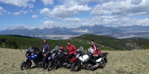
The Trails Preservation Alliance (TPA) and Rocky Mountain Adventure Riders (RMAR) invite riders to join us in the first annual Colorado Adventure Ride. The ride is a five-day adventure, starting in Cripple Creek, Colorado on 27 July 2014. It will truly be a phenomenal experience riding through some of the most fabulous areas our country has to offer. These riding areas are under attack and we risk losing access to them forever. With your help, we can continue the battle to defend your rights to these lands. So, this isn’t just an awesome riding experience, it’s a chance for riders to make a real impact to maintain their rights to access public lands. Both the TPA and RMAR are 100 percent volunteer organizations. The TPA works closely with the US Forest Service and Bureau of Land Management and advocates for fair and balance access to public lands. RMAR’s positively impacts rider’s lives by running events, where riders can experience adventure riding, while contributing to state and local trail organizations that share the mission. Join us and like-minded adventurers this year. Visit www.rmariders.org for more information and to register.
|
||
|
|
||
GAO Report on Forest Service Trails Financial Sustainability
|
May 5, 2014 |
|
| Talking points on the GAO Report on Forest Service Trails Financial Sustainability (GAO 13-618).
Complete report is available here: www.gao.gov/assets/660/655555.pdf Issued by the Government Accountability Office in June 2013 and found that only 25% of all forest service routes are financially sustainable. The conclusions of this report have been the basis for several new discussions with USFS representatives on motorized route development. This report is not the basis for closures of motorized/multiple use routes. Conclusions of the report supporting this position are: 1. The GAO analysis is very large in scope and addresses all types of trail usage including non-motorized routes in Wilderness areas. Non-motorized routes in Wilderness areas on Forest Service lands account for 20% of the total mileage of all Forest Service routes. 2. Maintenance of non-motorized Wilderness routes is exceptionally expensive when compared to multiple use routes, due to management limitations on types of management, limited access to areas and many of these routes have been heavily impacted by intense wildfire and Forest health issues. 3. OHV grant programs are specifically recognized as a significant contributor to maintenance of multiple use routes, even if these funding sources were not tracked by the Forest Service. The motorized program is the only significant funding source addressed in the report. Without this funding the overall funding picture would be far more grim as these programs very effectively leverage RTP monies. No similar program exists for the maintenance of non-motorized routes. 4. Winter motorized trails are not included in analysis and this usage is almost completely paid for by users on Forest Service lands. 5. Volunteers are specifically identified as a major resource for maintaining routes. The motorized community is the source of extensive volunteer efforts to maintain trails in addition to the direct funding that is provided. The report identifies that having the right forest service employee in place to work with volunteers is critical. We would agree 6. This report really provides no basis for the closure of multiple use routes. The loss of multiple use routes erodes user support for registration programs that provide significant effective funding for maintenance of multiple use routes and negatively impacts users desire to volunteer for maintenance activities.
|
|
|
|
|
Comments on Burn Canyon Comprehensive Travel Management
|
May 3, 2014 |
||
| Uncompahgre Field Office – Burn Canyon Trail Project
Att: Burn Canyon Travel Management Prior to addressing the specifics of these concerns, a brief summary of the Organizations is warranted. COHVCO is a grassroots advocacy organization of approximately 2,500 members seeking to represent, assist, educate, and empower all OHV recreationists in the protection and promotion of off-highway motorized recreation throughout Colorado. COHVCO is an environmental organization that advocates and promotes the responsible use and conservation of our public lands and natural resources to preserve their aesthetic and recreational qualities for future generations. TPA is a 100 percent volunteer organization whose intention is to be a viable partner, working with the United States Forest Service (USFS) and the Bureau of Land Management (BLM) to preserve the sport of trail riding. The TPA acts as an advocate of the sport and takes the necessary action to insure that the USFS and BLM allocate to trail riding a fair and equitable percentage of access to public lands. For the purposes of these comments, COHVCO and TPA will be referred to as the Organizations. 1. Significant changes in the scope of proposal must be completely addressed and simply have not been. The Organizations have significant concerns regarding the lack of meaningful analysis of many impacts that result from the changed scope of the project. Per scoping the scoping letter, the project seeks to develop a new single track multiple use trail network described as follows: While the Organizations vigorously supported the scoping in the original proposal, the Organizations are not able to support the direction now reflected in the preferred Alternative. The preferred alternative would: The Organizations must highlight the scope of change in direction of this project, which was scoped to provide 34 miles of multiple use single track and has now changed to providing no miles of multiple use single track in the preferred alternative. After a brief review of the comments provided in scoping and a complete review of the EA, the Organizations are wholly unable to identify any basis or concern that could be relied on for the significant changes in the proposal that are now identified. Given the prioritization of a single user group that is not able to fund any portion of the project over multiple use recreation in the planning area will increase user conflicts. These concerns are compounded by the fact that the user group that is being excluded is the only one to pay to assist with management of their recreational usage. These concerns are further compounded as the development of the proposal impairs assertions that agency money is being properly directed towards partnering to maintain and manage existing opportunities in the field office. It is the Organizations position that these impacts are unacceptable result for any user groups recreational activity and must be avoided in any plans that expand trail networks. If agency personnel are not able to fund maintenance of current opportunities, any assertion of sufficient funding being available in the future would be highly suspect. The Organizations agree that these materials are critically important in mitigating impacts and educating users and developing a trail system that is successful in the long run. The Organizations simply are not able to explain how these materials will be developed if there is no money to develop these resources for the area. The Organizations have to believe that simply developing these resources without changing current usage would result in a significant benefit for all user and achieve the goals and objectives of the proposal and completely avoid any possible negative impacts that would result from more opportunities that fail to address these known management issues that are currently unresolved. Additionally the UFO has recently provided a single track non-motorized trail network outside Ridgway and significant portions of the Domingez-Escalante NCA were designated for the benefit of non-motorized users. These are opportunities that must be balanced and weigh heavily in favor of Alternative 2 of the proposal in order to address the critical lack of motorized single track in Colorado. 6. Analysis of most resource specific issues is completely faulty. Benefits of moving from an open to existing route designation simply are not relevant to this proposal, as the area has been under existing roads and trails management standards since the adoption of the UFO TMP in 2010. If there are impacts resulting from off trail usage, these are now enforcement issues and probably the result of the specifically identified lack of signage and maps for the planning area rather than benefits of the EA. If these same management standards, such as no signage or maps for users area continued, off trail usage will continue regardless of the type of usage that is allowed. The Organizations vigorously assert that rather than attempting to assert benefits from previous management decisions, the proper question should be how to fund implementation and education of users regarding the newly adopted TMP. These concerns are more specifically addressed in previous portions of the comments. The Organizations are deeply troubled that the analysis of many resource issues provided in the EA exhibits a similar confusion of management standards in an effort to create a position that the proposal will be a benefit and there will be no impacts. The EA must be comparing the alternatives to current management of the area rather than to each other, which is commonly the case in the EA. The Organizations vigorously assert that much of the new trail network that is to be developed is in areas that simply have no trail network currently and are outside of possible impacts from existing opportunities. Any position that building a trail in an area that currently has none probably lacks factual or scientific basis and credibility. The proper question to be addressed is does the trail network negatively impact the area, which cannot be accurately addressed by merely comparing alternatives. Funding and ongoing maintenance of the trail is a critical component of this analysis, and must address issues like the proposed alternative provides for a 31% increase in routes that are on highly erodible soils. Regardless of who is using the routes, they will need maintenance. “Non-motorized winter recreational activities caused 89% of monitored moose to be displaced, while snowmobiles caused 50% displacement, and trucks caused 21% displacement. Furthermore, 100% of observed moose demonstrated disturbance behaviors when disturbed by skiers and snowshoers, moving an average of 80 yards away. In contrast, 94% of moose moved 50 yards when disturbed by snowmobiles.”12 Weeds and invasive species will be brought into areas and habitats that have been isolated previously. This will cause impacts that must be addressed. Monitoring and management of any outbreaks of invasive species will be problematic due the failure to provide funding for long term management. Again these are issues that the OHV Good Management crew currently in place on the UFO could easily address if this was a multiple use trail network. That maintenance and funding is illegal under the preferred alternative. Another failure of analysis of impacts that result from management changes in the preferred alternatives involves the management of critical winter range for wildlife. These areas are consistently closed to usage. Rather than apply these management standards the EA proposes to allow foot and horse traffic as follows: “Seasonal Closures – All designated routes in the Norwood-Burn Canyon Area would be closed to motorized and mechanized travel from December 1 to April 30 to prevent disturbance to wintering big game. …. Foot and horse travel would be allowed.”16 There is simply no scientific basis for allowing foot and horse usage of the area during winter range times. These usages are repeatedly identified as usages that acheive the highest and longest levels of response from wildlife. Allowing these usages while excluding others will generate a minimal benefit to the species that are relying on the area as winter range. Again the Organizations assert meaningful analysis of this standard must be undertaken to develop a plan for the usage of the area. Conclusion The Organizations vigorously support the development of additional multiple use single track trails in the planning area as reflected in Alternative 2 of the EA. These trails would help address the void of motorized single track riding opportunities that currently exists in the State of Colorado and more specifically in the areas surrounding the proposal. The Organizations believe that this proposal would provide a significant resources for all users of trail network as multiple use trail opportunities are very limited in the proposal area. The Organizations are vigorously opposed to the preferred alternative that is in the EA as this will directly limit the funding that is available and directly impact the ability to actually implement any of the rather extensive mitigation tools, such as parking, maps, kiosks and other resources that are identified as necessary under both current management and the preferred alternative. If you have questions please feel free to contact Scott Jones, Esq at 508 Ashford Drive, Longmont CO 80504. His phone is (518)281-5810 and email is scott.jones46@yahoo.com. Scott Jones, Esq. 1 BLM, Uncompaghre Field Office Burn Canyon scoping letter dated April 3, 2012. 2 See, BLM Uncompaghre FO, draft EA on Norwood-Burn Canyon Comprehensive Travel Management Plan; April 2014 at pg 13. This document is hereinafter referred to as the EA. 4 See, Government Accountability Office report to Congressional Requestors GAO-13-618; Forest Service Trails- Long and Short term improvements could reduce maintenance backlog and enhance system sustainability; June 2013 at pg. 5 See, EA at pg 29. 6 EA at pg 31. 7 EA at pg 2. 8 EA at pg 9. 10 San Juan Forest – Resource Management Plan 11 See, USDA Forest Service, Rocky Mountain Research Station; The Southern Nevada Agency Partnership Science and Research Synthesis; Science to Support Land Management in Southern Nevada; Executive Summary; August 2013 at pg 38. 12 See, Rudd, L. T., and L. L. Irwin. 1985. Wintering moose vs. oil/gas activity in western Wyoming. Alces 21:279-298. 13 See, Sime, C. A. 1999. Domestic Dogs in Wildlife Habitats. Pages 8.1-8.17 in G. Joslin and H. Youmans, coordinators. Effects of recreation on Rocky Mountain wildlife: A Review for Montana. Committee on Effects of Recreation on Wildlife, Montana Chapter of The Wildlife Society. 307pp.. 14 Rumble, Mark A; Benkobi, Lahkdar; Gamo, Scott R; 2005. Elk Responses to Humans in a Densely Roaded Area; Intermountain Journal of Sciences. 11(1-2); 10-24 @ pg 17-18. 15 EA at pg 34. 16 EA at pg 14.
|
||
|
|
||
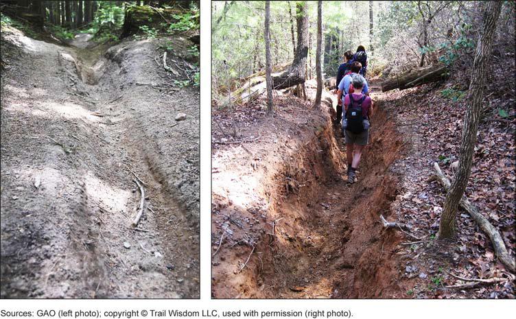
Protest/Appeal of Kremmling BLM FRMP & FEIS
| |
April 22, 2014 |
|
| Bureau Of Land Management Director (21 0) ATT: Protest Coordinator 20M Street SE, RM 2134LM Washington DC 20003 Protest/Appeal of Kremmling BLM FRMP & FEIS Dear Sirs: Prior to addressing the specific appeal points, a brief summary of each Organization is needed. The Colorado Off-Highway Vehicle Coalition (“COHVCO”) is a grassroots advocacy organization of approximately 2,500 members seeking to represent, assist, educate, and empower all OHV recreationists in the protection and promotion of off-highway motorized recreation throughout Colorado. COHVCO is an environmental organization that advocates and promotes the responsible use and conservation of our public lands and natural resources to preserve their aesthetic and recreational qualities for future generations. The Trail Preservation Alliance (“TPA”) is a 100 percent volunteer organization whose intention is to be a viable partner, working with the United States Forest Service (USFS) and the Bureau of Land Management (BLM) to preserve the sport of trail riding. The TPA acts as an advocate of the sport and takes the necessary action to insure that the USFS and BLM allocate to trail riding a fair and equitable percentage of access to public lands. Colorado Snowmobile Association (“CSA”) was founded in 1970 to unite winter motorized recreationists across the state to enjoy their passion. CSA currently has 2,500 members. CSA has become the voice of organized snowmobiling seeking to advance, promote and preserve the sport of snowmobiling by working with Federal and state land management agencies and local, state and federal legislators. For purposes of this appeal, Colorado Off-Highway Vehicle Coalition, the Trail Preservation Alliance and Colorado Snowmobile Association will be referred to as “the Organizations” in this appeal. The Organizations are vigorously opposed to the arbitrary and capricious manner that all economic analysis of recreational usage has been undertaken in the RMP and FEIS, despite recreational usage of the planning area being repeatedly and consistently identified in the RMP and FEIS as the primary usage of the planning area. The Organizations are deeply concerned with the accurate analysis of recreational spending in the planning process, as this is the primary method of recognizing recreational activity on public lands. This faulty analysis has led to daily spending profiles, total jobs estimates and total recreational spending amounts that are so low as to lack any basis in law or fact and directly conflict with BLM species specific analysis of the KFO planning area, USFS conclusions and process that have allegedly been relied on and analysis from a variety of other sources. The Organizations vigorously assert that the KFO conclusions are arbitrary and capricious as a matter of law as the KFO repeatedly asserts application of USFS NVUM process in the KFO economic analysis but comes to conclusions that represent less than 20% of the average daily recreational spending found in the NVUM process. KFO conclusions on average daily recreational spending simply are insufficient to allow visitors to buy fuel and return home from a visit to the KFO planning area. The arbitrary and capricious nature of KFO conclusions on recreational spending is further evidenced by comparisons of the KFO economic analysis of recreational spending per day, which provides conclusions of $16.21 per day to that have been reached in the BLM Greater Sage Grouse analysis, which finds average recreational usage to be valued at $121.96 per day. The Organizations vigorously assert this is prima facie evidence of the arbitrary and capricious nature of the economic analysis on the KFO as these analysis have occurred at basically the same time, using the same analysis methods and almost all the KFO planning areas are identified as GRSG habitat. The KFO allocation of resources in the RMP is the direct result of a failure to meaningfully incorporate meaningful analysis of economics into the planning for and balancing of uses on the FO moving forward. Throughout this appeal, the Organizations are forced to guess at numerous critical factors for economic analysis of recreation. The Organizations vigorously assert that these forced guesses at factors is direct evidence of a failure to comply with NEPA requirements of a detailed statement of high quality information and a hard look regarding the decision making process. Not only are these guesses direct evidence of a failure of NEPA, these failures have directly impaired the Organizations ability to create meaningful appeal points and discussions, which has further prejudiced the Organizations. The arbitrary and capricious manner that economic analysis has been handled is further evidenced as conclusions simply have not been integrated in any manner into the KFO planning process, which appears to have merely filled in boxes on a form rather than integrate conclusions and analysis together. This position is directly supported by the changes between draft and final versions of these documents that doubled recreational visitation and spending but cut the number of jobs that result in local economies from this activity almost in half. This simply lacks any basis in law or fact. The lack of integration of economics in the planning process is further evidenced by the fact that visitation between the draft and final versions of the plan has doubled but the amount of recreational opportunity has been reduced even further from the preferred alternative in the draft, without explanation. The Organizations vigorously assert that serving twice as many people with more than 50% less resources is a management position that warrants discussion. The Organizations would be very concerned regarding the factual and legal basis of this discussion if it were to be presented. It is the Organizations position that the FEIS and RMP must be remanded to the Field Office for further analysis of the issues more specifically addressed in this appeal. The analysis of these issues and associated balance of uses that will result from meaningful analysis and a hard look at accurate information must then be provided to the public for an additional comment period. It is the Organizations position that an RMP for this area that is based on accurate economic information and accurate application of management standards will look significantly different that the current management standards sought to be applied. 1. Introduction Note: This is only the first four pages of this document, to read it in its entirety please download the PDF (top of page). If you would like to see any of the attachments please contact us.
|
||
|
|
||
Basalt to Gypsum Motorized Singletrack
| |
April 16, 2014 |
|
| Scott Fitzwilliams, WRFNF Supervisor Att: John Thompson, Nat Resource Specialist 620 Main Street Carbondale, CO 81623-0309 RE: Basalt to Gypsum Motorized Singletrack Dear Mr Thompson; The Trail Preservation Alliance (“TPA”) is a 100 percent volunteer organization whose intention is to be a viable partner, working with the United States Forest Service (USFS) and the Bureau of Land Management (BLM) to preserve the sport of trail riding. The TPA acts as an advocate of the sport and takes the necessary action to insure that the USFS and BLM allocate to trail riding a fair and equitable percentage of access to public lands. For purposes of these comments, COHVCO and TPA will be referred to as “the Organizations”. The Organizations vigorously support the above proposal, as the construction and adoption of these single track routes will help address a critical shortage of motorized single track trails in the White River National Forest. The benefits to the motorized community are expanded beyond the scope of the current proposal, as the proposal ties two existing trail networks The Organizations are very aware that there is considerable opposition to the project despite the significant benefits to all users and mitigation of existing resource issues in the area. This opposition manifested itself in the grant application process with the Colorado State Parks and Wildlife OHV Grant proposal. While the Organizations did not participate in the on-site visits discussed below, the Organizations were involved in resolving concerns surrounding the grant as the process by which the Basalt to Gypsum trail grant was removed from the other motorized grants of that year was very concerning for the Organizations. The Organizations vigorously assert that opposition to the Proposal had more to do with an ideological opposition to the construction of motorized trails in the area rather than specific concerns about the proposal. The ideological opposition to the grant proposal resulted in an on-site inspection of the proposal area by CPW recreation staff, USFS representatives, USFWS biologists, and CPW biologists and wildlife managers. After the on-site review of the grant proposal, managers and experts all agreed that there were significant benefits to all usages and improvements to wildlife habitats and other resource issues from the project. These determinations were based on the managers expert opinions and application of best available science for management of species and other issues. The Organizations believe that best available science must again be relied on in addressing these alleged issues as part of the NEPA process and the previous determinations of the resource managers with regard to the grant application must be given heavy weight in the NEPA process. The Organizations concerns regarding incorporation of previous analysis of the grant proposal are based on the failure of the scoping notice to provide meaningful discussion of these meetings and that the scoping notice now specifically identifies many of the same resource issues as part of the “Effects and Issues to Consider” portions of the scoping notice as were addressed in the grant proposal meetings. While the Organizations understand that NEPA must be an impartial process, the Organizations believe a full representation of the history of the project should be addressed in the scoping and is highly relevant to the NEPA process. The Organizations believe a full representation of the project history would have resulted in issues and possible impacts being addressed in a more balanced manner, especially when considering the motorized community is partnering to resolve impacts from multiple usage of the area previously. The Organizations are concerned that highlighting all the potential impacts of the project without also identifying benefits to the community and resources that will clearly result may expand opposition to the project based on issues and concerns that have truly already been addressed and resolved in the grant process. Creating opposition to the project based on issues that have already been resolved should be avoided. The Organizations are also concerned that the Proposal is the result of the partnership of Ranger District staff and local user groups. These partnerships are highly valued by the user groups that have participated in the planning process, but many recreational users are opposed to these type of collaborations for a variety of reasons, mainly based on a distrust of land managers and the position that user groups should fight with land managers rather than partner with them. While overly resource protective provisions in the scoping notice may appease those opposed to the proposal, these same provisions are also relied on by those that oppose collaborative partnerships as proof that the agency is not truly partnering with the user groups. While the Organizations do not share these users perspectives, fueling these beliefs does not work towards addressing these erroneous concerns moving forward. The Organizations vigorously support the Proposal, as the proposal will address a critical shortage of recreational opportunities that currently exists on the White River National Forest and mitigates many existing issues regarding resources in the proposal area. If you have questions please feel free to contact Scott Jones at 508 Ashford Drive, Longmont, CO 80504. His phone is (518)281-5810. Sincerely, D.E. Riggle, Director of Operations
|
||
|
|
||
Protest/Appeal of Colorado River Valley BLM FRMP and FEIS
|
April 3, 2014 |
||
| The Colorado River Valley BLM FRMP & FEIS closes about 50% of routes (1000) in the area and fails to analyze most impacts to recreational usage like off trail snowmobile usage at all.
This is another plan that tragically undervalues recreational usage and anytime other uses are balanced with recreational usage, recreational usage loses. Examples would be endangered species and cultural sites. They apply the most restrictive standards possible for ESA and anything they think could be a cultural site now or in the future is subject to a mandatory closure. Bureau Of Land Management Director (21 0) Protest/Appeal of Colorado River Valley BLM FRMP & FEIS Dear Sirs: To continue reading, please download the attached PDF.
|
||
|
|
||