GMUG National Forest
Att: Forest Plan Revision
2250 South Main Street
Delta, CO 81416
Dear Sirs:
Please accept this correspondence as the comments of the above Organizations with regard to the release of the Draft GMUG Resource Plan (“hereinafter referred to as “the Proposal”). Of the Alternatives provided, Alternative C of the Proposal is the best presented but this Alternative needs significant work. A major step forward in Alternative C would be the inclusion of a landscape level management standard that creates a protective corridor around any route where the route is inconsistent with adjacent management or ROS. This is justified as every route on these maps has been through travel management multiple times. We are also concerned that in some geographic areas that Alternative B provides far better access than Alternative C, despite the assertion that Alternative C is the most intensive level of access.
We think Alternative C is the most accurate reflection of current management and are opposed to Alternative D of the Proposal. Candidly, Alternative D is so unrealistic we are going to avoid substantive discussion of many of the standards in this Alternative. Alternative D represents a huge number of areas that we have sought to protect in previous collaboratives. Often these previous NEPA collaboratives were undertaken only with significant effort and compromise from the member Organizations, is deeply disappointing to the Organizations and our members as often much of what has been proposed in citizen alternatives and sometimes alternatives in the Proposal are exactly the discussions previously raised, subsequently reviewed in NEPA and then declined to be applied.
We are unsure what Alternative A of the Proposal is attempting to reflect, as this mapping and information directly conflicts with current management designations of many areas. Alternative A is the result of the failure to accurately, consistently and completely reflect many of the site specific NEPA components, analysis and decisions that has occurred over decades on the GMUG within the existing management decision framework.
In a more troubling twist, often the inventory of site-specific analysis done within existing management designations is sought to be applied in a manner that directly conflicts with the clear scope of those efforts. Management designations are management designations and inventories are inventories and these are not concepts that can be interchanged at will in the planning process. Our concerns around the Draft RMP would include:
- We welcome the brief nature of the RMP but at this point are confused by many of the assertions on management that have been made and subsequently changed in this process such as existing ROS scope;
- We continue to struggle with the challenge regarding accurate integration and representation of existing NEPA and statutory changes that have occurred over the life of the 1983 RMP; While we appreciate efforts to provide public better information on possible impacts often this info was late and as a result, we are asking for existing motorized routes be provided a protective Corridors when these previously analyzed routes cross areas of inconsistent management;
- Inventory levels for motorized areas have reduced by 24% over the life of the 1983 plan based on subsequent NEPA when these site-specific decisions clearly and unequivocally state there was no change to management standards is within the scope of that analysis and these are existing expansion areas for motorized usage and we can’t discuss them as this information is not provided;
- Roadless area inventory of limited area characteristics are now sought to be applied as a management standard for all uses of these areas. This confuses the public in planning and will create confusion over the life of the RMP.
- Populations of wildlife on the GMUG have been steady and increasing over the life of the 1983 RMP, based on published peer reviewed information from CPW and as a result we must question why there would be significant restrictions imposed to protect wildlife beyond those already in place.
- The large-scale implementation of a draconian mile for mile route density standard in wildlife management areas conflicts with USFS and CPW published and peer reviewed guidance on this issue. We are unable to local any species whose habitat is actually entirely under this threshold causing significant concern regarding assertion from the Forest of minimal impacts from this standard;
- Winter ROS information is woefully inadequate and as a result we are asking that any winter ROS decisions be postponed until adequate information is available and can be incorporated in subsequent travel plans for the issues; and
- There simply needs to be more access to the forest for all types of recreational usages, which was confirmed by the complete overrunning of existing facilities in 2020;
Prior to addressing the specific concerns, we believe a brief summary of each Organization is needed. The Colorado Off-Highway Vehicle Coalition (“COHVCO”) is a grassroots advocacy organization of approximately 2,500 members seeking to represent, assist, educate, and empower all OHV recreationists in the protection and promotion of off-highway motorized recreation throughout Colorado. COHVCO is an environmental organization that advocates and promotes the responsible use and conservation of our public lands and natural resources to preserve their aesthetic and recreational qualities for future generations. The TPA is an advocacy organization created to be a viable partner to public lands managers, working with the United States Forest Service (USFS) and the Bureau of Land Management (BLM) to preserve the sport of motorized trail riding and multiple-use recreation. The TPA acts as an advocate for the sport and takes the necessary action to ensure that the USFS and BLM allocate a fair and equitable percentage of public lands access to diverse multiple-use trail recreational opportunities. CORE is a motorized advocacy and trail work group. They have performed several thousand hours of volunteer work over the past four years in the Gunnison National Forest restoring roads and motorized trails. Colorado Snowmobile Association (“CSA”) was founded in 1970 to unite winter motorized recreationists across the state to enjoy their passion. CSA has also become the voice of organized snowmobiling seeking to advance, promote and preserve the sport of snowmobiling through work with Federal and state land management agencies and local, state and federal legislators telling the truth about our sport. Collectively, TPA, CSA, CORE and COHVCO will be referred to as “The Organizations” for purposes of these comments.
The Organizations are very concerned that one of our foundational concerns around the GMUG effort has not been addressed consistently or accurately, and that is developing an accurate reflection of current management on the GMUG. This concern is the fact that site specific NEPA has been undertaken on the GMUG for decades and that this NEPA must be applied accurately and meaningfully on the Forest to represent Alternative A of the Proposal. The development of an accurate Alternative A is foundational to our ability to compare alternatives and to understand where existing expansion areas might be located. An accurate understanding of Alternative A also allows us to avoid unintended consequences of the proposed alternatives on issues that were simply not analyzed accurately under Alternative A of the RMP.
Our concerns around the accurate reflection of current management and collaborative efforts around Wilderness designations began with the high levels of Wilderness recommendations in some discussions. This is an issue we are passionate about as we have worked hard over the last 40 years to have areas protected as Wilderness in concert with the specific release of other areas important to our interests by Congress for Non-Wilderness multiple uses. We believe all portions of these legislative efforts are equally worthy of recognition in any planning. We would not even ask to put a motorized trail in a Wilderness area as this is a non-starter of an issue. We believe that requests for recommended Wilderness designations in areas previously released for multiple use should be equally a non-starter from a management perspective. We are thankful this issue has been resolved in early versions of the plan after extensive discussions with GMUG staff on this issue.
Our concerns around accurate inclusion of existing decisions and NEPA continued in 2018 in response to the GMUG proposal to designate the Continental Divide National Scenic Trail for horse and hike use only. This was again conflicting with previous Congressional determinations on the use of the trail. This standard was in direct conflict with Rio Grande NF planning efforts and either forest changes to management standards could have catastrophic impacts to motorized access on both forests. This was in direct conflict with specific provisions of the National Trails System Act and the extensive programmatic level NEPA analysis that had been previously undertaken to ensure consistent management of the CDNST without regard to forest level boundaries and allowed many uses on various segments of the CDNST. We thank GMUG planners for resolving this concern as a result of our pre-NEPA process comments but we feel it is important to recognize this as the first problematic integration and reflection of existing management and NEPA analysis in the GMUG planning effort. The CDNST issue is unfortunately not the last time we have seen this type of failure in the GMUG planning effort.
The application of existing NEPA in the GMUG planning efforts was again raised by motorized interests after several public meetings were held by partner groups, such as the series of workshops held by Western States University entitled “Winter Recreation Citizen Science Public Workshops” in January and February of 2020. The motorized users were astonished to hear assertions such as: “There has never been winter travel management on the GMUG” actually being validated by USFS staff in the meetings despite the entire GMUG having winter travel management in place. Our concerns on issues on proper integration and recognition of previous NEPA efforts was again addressed the importance of existing NEPA decisions with USFS staff and we again thought this issue was resolved. This issue remains of paramount importance to our concerns and appears to be an issue that has again been overlooked in the GMGU process.
After seeing the first draft of the Proposal, Wilderness designations and releases, the CDNST concerns and winter travel appear to be the tip of a much larger issues around accurately applying existing NEPA on the forest. NEPA has been performed on the forest and simply is not accurately reflected in Alternative A, as some conclusions are ignored and other conclusions are applied in manners that directly conflict with the site or issue specific NEPA. Are we glad these issues are resolved properly, that answer is of course yes but the process has been long and slow.
1(a)(1) Better than the Manti
The Organizations participate in the development of forest plans and travel plans throughout the region and this gives us a somewhat unique perspective on unusual issues. One such issue would be the adoption of the pre-NEPA public review concept on both the GMUG and Manti/LaSal NF at roughly the same time. While both forests have chosen to adopt this new principle, the GMUG has proactively used this process to its fullest advantage by taking the public input that was received earlier in the process and attempting to address this round of public input with a revision of the initial draft. The Manti chose to simply release their initial draft twice without revising the initial draft in response to the public input. While this additional comment period is appreciated, providing some type of meaningful feedback on initial comments would have been superior. The GMUG planners should be commended for undertaking this early revision of their proposal between pre-NEPA and commencement of NEPA process as adding additional input on Wilderness and CDNST issues would expand these comments even more. We believe this step will provide a more accurate plan and sends an important message to the public that their input matters.
1(a)(2) Shorter is better.
The Organizations welcome the generalized and shorter nature of the RMP when compared to the former GMUG. Landscape level plans can be very long and detailed and this length has proven to be a significant barrier to public participation in the planning process as most of the public lack the time or resources to review such a large planning document. This causes the public to oppose the plan even when there are very good things for the public in the plan.
These overly complex and detailed plans also shorten the life and value of the plan as the plan simply lacks flexibility to adapt to changes in science or unforeseen challenges at the time of development. When these changes are encountered, the plan is simply irrelevant factually or recommending management that simply makes no sense in addressing on the ground issues. The current forest health situation on the GMUG provides a perfect example of why RMPs must be flexible and avoid overly detailed analysis, mainly that the GMUG is dealing with areas of the forest where tree mortality is easily at or above 90%. The Organizations submit that the current RMP has been a significant barrier to addressing this challenge, as planners in 1983 were simply unable to understand the scope of the challenges that the forest could be facing almost 40 years after the plan was adopted. Again, these types of overdetailed analysis represent a situation that should be avoided in the development of the new GMUG RMP. Shorter is better.
While the Organizations continue to vigorously support the shorter is better concept for the new plan, this desire should not be construed as a desire to avoid accurate analysis of the NEPA on the forest and the existing RMP and supplements. The creation of an accurate summary of current management on the forest in Alternative A is a critically important step for the meaningful analysis of alternatives that are being proposed and this is a process that the USFS planners are uniquely situated to accurately address. Too often in the Proposal development has this responsibility fallen to the public.
The Organizations believe this shorter is better model is also applicable to protecting access. This is why we are asking for a standard to protect existing routes that have been the basis of extensive travel planning be provided a landscape level management standard to protect these routes that may cross areas of inconsistent management. Not only is it difficult to almost impossible for the public to identify every route in this situation, this presumption also ensures that these routes continue to be protected during subsequent revision processes to address uses and boundaries in response to the current public input.
1(a)(3) We simply need better and more access for all forms of recreation and management.
Another landscape level concern for the RMP would be the desire of the Organizations to clearly and vigorously state that access to the GMUG needs to be improved and expanded when compared to Alternative C. There are simply too many barriers to access to the forest for both recreation and management of the forest moving forward. The organizations are concerned that often portions of existing NEPA reviewed trails are provided more protection under Alternative B than Alternative C. This is perplexing at best and must be corrected.
We believe this access is critical to the continued ability of the forest to provide high quality recreational access to all but also to dealing with the catastrophic wildfires that have become so commonplace. Fighting fires is difficult enough but having to try and build or reopen routes that are only administratively open while fighting a fire makes the firefighting functionally impossible. These concerns are discussed more subsequently but the need is clearly evident from the overwhelming use of recreational resources that occurred in 2020. The GMUG also needs to learn from the firefighting efforts on other forests in response to the monster fires that have now become far too common. From our perspective bringing in a hot shot crew from outside the region and then having a crew like this open trails and routes for basic access is a tragically inefficient use of that crews’ skills and the exceptionally limited funding that is available. If access is maintained more consistently, poor allocations of resources are avoided in times of crisis and the Organizations have provided almost $1 million per year to the GMUG for a long time to provide this type of maintenance, making this management direction a double win.
1(b) The motorized community has a long history of effectively collaborating with everyone to resolve challenges on the GMUG.
The Organizations would like to discuss a foundational difference between the way the motorized community collaborates when compared to other interests. The Organizations and our membership have a long history of collaborating with land managers to address a wide range of issues and challenges on the GMUG and vetting these conclusions through the NEPA process. The Organizations have embraced this type of collaboration in the hope that issues can be permanently resolved and managers and users can enjoy the recreational opportunities on the GMUG now and into the future. Candidly, it can be very tiring for our members to talk about the same areas and issues over and over and over again.
Often, many that have collaborated around NEPA efforts have consistently sought to reopen collaborative decisions made with the USFS within a short time of their conclusion, often asserting positions that are directly in conflict with the scope of the NEPA. Often the basis for the desire to reopen NEPA is basically the same concern that initially drove NEPA analysis and that other parties in the effort thought were resolved. Too often we have had to remind everyone about these collaborations scope and NEPA basis before entering any further discussions, and our desire is to address issues or concerns as much as possible and move on. This often is asserted as obstructionist behavior by those that want to continue discussions. We vigorously assert that this type of closure is the implementation of the collaborative process. The Proposal appears to be another effort that the motorized community will have to serve as the forest historian to allow analysis to commence from an accurate and meaningful management position. Many of the issues that would be reopened in the Proposal over its life we view as issues that have been resolved in previous collaborations around NEPA. The Organizations and our members are hesitant to reopen many of these decisions as the previous NEPA was painful and resulted in large scale restrictions in some areas.
Another significant difference in our collaborations and NEPA implementation is the fact we bring funding to implement decisions to the table. The motorized community has worked hard with the USFS, CPW and BLM to provide funding to address actual on the ground issues and currently this has resulted in a grant program for motorized recreation that provides almost $8 million per year in direct funding to land managers to benefit everyone across the state. As we have previously outlined in our comments, this results in almost $1 million per year coming to the GMUG for funding of staff, crews and site-specific projects. Motorized collaboratives have been hugely successful on addressing on the ground issues and challenges for the benefit of everyone on the GMUG and have become so effective in addressing issues that they are easily overlooked. This model of partnership with the forest is starkly different from most other collaboratives, who often create lists of demands and goals for the forest but provide little to no funding to implement these goals. With this section of our comments the Organizations are highlighting these partnerships to ensure they are properly weighted and recognized in the planning process.
2b. USFS partnerships reports could provide high quality information on partner resources.
With the passage of the National Forest System Trails Stewardship Act in 2016, Congress mandated the creation of a volunteer strategy report to improve partnerships between land managers and user groups for the benefit of trails on federal public lands. While this report is not to be published until 2018, this report should be highly relevant in addressing budgetary shortfalls and identifying partners where resources are more limited and partners where resources are more available as the report requires:
” (b) REQUIRED ELEMENTS. —The strategy required by subsection (a) shall—
- augment and support the capabilities of Federal employees to carry out or contribute to trail maintenance;
- provide meaningful opportunities for volunteers and partners to carry out trail maintenance in each region of the Forest Service;
- address the barriers to increased volunteerism and partnerships in trail maintenance identified by volunteers, partners, and others;
- prioritize increased volunteerism and partnerships in trail maintenance in those regions with the most severe trail maintenance needs, and where trail maintenance backlogs are jeopardizing access to National Forest lands; and”
The largest single partner with both the BLM and USFS in Colorado is the motorized trail user community, both in terms of direct funding to land managers through the CPW Trails Program and with direct funding and resources from clubs in the GMUG planning area. The partnership’s impact is further expanded by the fact that all motorized routes on the GMUG are available for all other recreational activities. The major barrier to partnerships is closures of routes when resources are available to address the resource concerns that are the basis of the route closure and the failure to treat all recreational user groups in a similar manner.
The identification of partner resources available to GMUG managers must be a major priority in the development of the RMP as well. While there are many partner groups who volunteer time and resources in partnership with GMUG managers, the OHV community is the only partner that provides direct and consistent funds to GMUG managers through the CPW OHV grant program to assist in achieving sustainable recreational opportunities. The USFS Regional office has clearly identified that just the OHV program in Colorado more than doubles the amount of agency funding that is available for recreational activity on USFS public lands. After a review of the CPW Statewide Good Management Crew program based in the Sulphur Ranger District of the Arapahoe/Roosevelt NF managers clearly identified that CPW OHV good management crews were provided money in a more consistent and timely manner than the funding that was provided through USFS budgeting and over time the CPW program funding had significantly increased while USFS budgets had significantly declined. There is simply no basis for a decision that this long-term reduction in funding will change and this should be factored into planning for projects on the ground.
In 2017, GMUG managers asked for almost $600,000 in direct funding for annual summer maintenance crews and for site specific projects from the CPW OHV program alone. This funding provides three trained seasonal crews who perform on the ground trail maintenance, provide basic maintenance services for more developed sites and expand the law enforcement presence on the GMUG. Additionally, these crews are able to leverage a significant amount of mechanized equipment in the GMUG planning area, such as the several Sutter trail dozers, mini-excavators and tractors owned by local clubs to address larger maintenance challenges in a very cost- effective manner. We have attached the Ouray RD good management crew grant application to the CPW OHV program (#6) and OHV dozer (#5) application as exhibits with these comments in order to provide clear documentation of the support coming from the CPW OHV program to GMUG managers and the success of these partnerships in maintaining trails.
The availability of these resources exemplifies the strong relationship that the GMUG resource managers have with some of the strongest partner clubs in Colorado, and probably the Nation including the Thunder Mountain Wheelers, West Slope ATV, Grant Mesa Jeep Club, Western Colorado Riding Enthusiasts (WESTCORE) and Uncompahgre Valley Trail Riders. These clubs routinely work on projects, such as bridge construction and heavy trail maintenance, that are simply beyond the scope of comprehension on most other forests. These clubs also provide extensive additional funding for resource maintenance such as grants obtained from the Extreme Terrain Grant Program, BF Goodrich Tires Exceptional Trails and Yamaha Access grant program and Polaris TRAILS grants. This funding easily exceeds another $100,000 per year in funding that is available to maintain routes on the GMUG and other public lands in the vicinity.
In addition to the OHV grant funding and exceptional partnerships available through summer use clubs, CPW funding through the Snowmobile Registration Program provides an additional $500,000 in funding to local clubs for operation of the grooming programs, who maintain almost 400 miles of multiple use winter trails on the GMUG. The snowmobile registration program further partners with the local clubs to purchase grooming equipment used on these routes, which now is consistently exceeding $200,000 to purchase used. This CPW funding is again leveraged with exceptional amounts of volunteer and community support for these grooming programs from local clubs and oftentimes the CPW funding is less than half the operational budget for the clubs maintaining these routes. These winter trails are the major access network for all users of GMUG winter backcountry for recreation and all these opportunities are provided to the general public free of charge.
While there has been a significant decline in direct funding through the agency budget process, motorized partners on the GMUG have been able to marshal resources at levels that are unheard of in other forests for the benefit of all recreational users. The Organizations would ask that if budget constraints are identified as a challenge for recreational usage of the forest moving forward, that these constraints are applied to all recreational usages and that the fact that the GMUG has been the beneficiary of some of the strongest partnerships with the motorized community in the country for literally decades be properly balanced in addressing any budget shortfalls.
In addition to the collaborative management resources that have been available for the benefit of all users of the GMUG, the motorized community has worked hard to address all types of conflict and challenge around recreational usage on the GMUG. As we have outlined in previous comments, these collaborations have facilitated the passage of Wilderness legislation that created Wilderness areas and also released other areas back to multiple use. The Organizations submit these efforts stand in stark contrast to the single minded exclusionary and often inflammatory collaboratives that now seem commonplace around the GMUG planning efforts.
2(a). Existing NEPA and management is not reflected in Alternative A.
The Organizations are very concerned that Alternative A of the Proposal often fails to address site specific NEPA that has been undertaken and/or seeks to apply these decisions in manners that are specifically outside the scope of the NEPA analysis. While the Organizations appreciate the GMUG efforts to resolve these concerns during the public comment period these efforts were late in the comment period and created a significant amount of confusion with our members who were often approaching us asking: “What should we comment on now? The Original or the new information?” Our answer to this type of question has been both and we are adopting the same policy here.
Rather than address existing management designations that have not been altered over the life of the plan, the original version of Alternative A of the Proposal appears to base analysis on inventories of characteristics that are often highly subjective and arbitrary. Additionally, these inventories have been done without NEPA rather than current management designations that are exhaustively reviewed in the NEPA process for the 1983 plan. Often other foundational decisions of these site-specific analysis are not discussed as far more restrictive standards for the issue are simply asserted to be best available science. An example of these types of concerns would be:
- The consistent assertion that only 40% of the GMUG has an ROS inventory in place;
- Management area designations have reduced by 24% over the life of the 1983 plan based on subsequent NEPA when these site-specific decisions clearly and unequivocally state there was no change to management standards is within the scope of that analysis;
- Roadless inventory of limited area characteristics are now sought to be applied as a management standard;
- The complete lack of analysis of existing route density decisions in ESA habitats and critical watersheds on the
Each of these concerns will be addressed with much higher levels of details in subsequent portions of these comments, but the Organizations believe the common ground of all these concerns provides a starting point for analysis. It is well established that NEPA regulations require an EIS to provide all information under the following standards:
“… It shall provide full and fair discussion of significant environmental impacts and shall inform decision makers and the public of the reasonable alternatives which would avoid or minimize adverse impacts or enhance the quality of the human environment Statements shall be concise, clear, and to the point, and shall be supported by evidence that the agency has made the necessary environmental analyses “1
NEPA regulations provide as follows:
“(b) NEPA procedures must ensure that environmental information is available to public officials and citizens before decisions are made and before actions are taken. The information must be of high quality. Accurate scientific analysis, expert agency comments, and public scrutiny are essential to implementing NEPA. “2
The Organizations believe a brief summary of the standards that are applied by Courts reviewing agency NEPA analysis is relevant to this discussion as the courts have consistently directly applied the NEP regulations to EIS review. Relevant court rulings have concluded:
“An EIS serves two functions. First, it ensures that agencies take a hard look at the environmental effects of proposed projects. Second, it ensures that relevant information regarding proposed projects is available to members of the public so that they may play a role in the decision-making process. Robertson, 490 U.S. at 349, 109 S.Ct. at 1845.”3
The Organizations have consistently sought to partner with GMUG planners to comply with the above requirements in the development of site specific NEPA on a wide range of issues and concerns. The Organizations and our members are deeply disappointed at the inaccurate summary of efforts that did not address access or only sought to address limited aspects of recreation that has now been portrayed as significant changes in existing management in Alternative A of the Proposal.
2(b)(1) Alternative C is the only alternative that complies with many landscapes level Congressional decisions about land use on the GMUG.
As the Organizations have noted throughout these comments, we have consistently come to the table to work out a wide range of issues that have been encountered on the GMUG. This collaboration has addressed both NEPA driven efforts on the Forest and citizen driven efforts that impact the management of the GMUG. The Organizations assert that Alternative C is the only alternative that reflects the consensus and collaboration that has been reached outside the NEPA process on political questions such as Wilderness designations and releases. Communities have collaborated and moved almost all recommended Wilderness in the 1983 plan to Congressionally designated Wilderness. Communities have also worked hard to gain Congressional release of areas from future designations and Alternative C reflects these Congressional releases and the Organizations believe this is crucially important moving forward. The Organizations discussed these designations and decisions in great detail in the comments submitted by the Organizations in response to the Wilderness Assessment of the GMUG on May 31, 2018 and remain a major concern for the Organizations. 4
2(b)(2). EO 14008 issued on January 27, 2021 by President Joe Biden mandates improved recreational access to public lands.
The Organizations are aware there has been an increase in public concern on issues that are truly a success on the GMUG or are based on partial summaries of large-scale actions that have been taken by the President or Governor. The recent issuance of Executive Order # 14008 by President Biden on January 27, 2021 would be an example of a decision that is only partially summarized in most materials we are seeing, as the 30 by 30 concept is memorialized in this order. It is our position that the 30 by 30 concept was long ago satisfied on the GMUG as 50% of the GMUG is either Congressionally designated Wilderness or Roadless area. In direct contrast to the materials we are seeing, this Order had provisions protecting lands generally but also had specific goals of improving access to public lands.
The only Alternative that complies with these specific recreational access goals of improving access is Alternative C. §214 of EO 14008 clearly mandates improved recreational access to public lands through management as follows:
“It is the policy of my Administration to put a new generation of Americans to work conserving our public lands and waters. The Federal Government must protect America’s natural treasures, increase reforestation, improve access to recreation, and increase resilience to wildfires and storms, while creating well- paying union jobs for more Americans, including more opportunities for women and people of color in occupations where they are underrepresented.”
The clear and concise mandate of the EO to improve recreational access to public lands is again repeated in §215 of the EO as follows:
“The initiative shall aim to conserve and restore public lands and waters, bolster community resilience, increase reforestation, increase carbon sequestration in the agricultural sector, protect biodiversity, improve access to recreation, and address the changing climate.”
217 of EO 14008 also clearly requires improvement of economic contributions from recreation on public lands as follows:
“Plugging leaks in oil and gas wells and reclaiming abandoned mine land can create well-paying union jobs in coal, oil, and gas communities while restoring natural assets, revitalizing recreation economies, and curbing methane emissions.”
The Organizations are aware of significant concern raised around the 30 by 30 concept that was also memorialized in EO 14008. While the EO does not define what “protected” means, the EO also provides clear and extensive guidance on other values to be balanced with. From our perspective the fact that the GMUG is currently managed as 30% roadless and almost 20% Congressionally designated Wilderness far exceeds any goals for the EO. From our perspective, the only alternative that complies with EO 14008 is Alternative C as the GMUG has exceeded the 30% threshold and also must improve recreational access. Improving access and revitalizing recreation economies simply will not happen with significantly expanding restrictions on access such as the 27% increase in areas generally closed to the public as proposed in Alternative D of the Proposal. While Alternative C of the Proposal starts to satisfy these requirements, this Alternative does not go far enough as we believe many of the foundational assumptions around Alternative C have been heavily influenced by faulty information that has been provided to USFS staff from other partners.
2(b)(3) The Goals of the Congressionally mandated USFS National Trails Strategy only aligns with Alternative C of the Proposal.
The USFS has been developing the National Sustainable Trails Strategy for the last several years5, to comply with the mandate of the National Trails Stewardship Act of 2016.6 The National Trails Strategy has a clearly identified goal of improving sustainable access and partnerships as a goal of this Congressionally mandated effort. This strategy also sought to strategically change how the USFS looks at partners and sustainability of routes and given the Proposal will guide the sustainable access and partnerships on the Forest for the foreseeable future. The Organizations are commenting on this issue given the fact this effort is simply never mentioned in the Proposal, despite the Congressional mandate. The National Strategy clearly states this as follows:
“Strategic Intent
The strategic intent of the strategy is to embrace and inspire a different way of thinking—and doing—to create sustainable change where grassroots initiative meets leader intent. The combined effort and momentum of many minds and hands will move the trails community, as a whole, toward shared solutions. This strategy builds on the many examples from across the country where the Forest Service, its partners, and the greater trails community have successfully embraced a community-driven and locally sustainable trail system model.”7
As we have noted throughout these comments the motorized community has worked hard to develop community driven locally sustainable trail systems on the GMUG for decades. While the motorized community is far from perfect, the motorized community is the only community that brings significant resources to the GMUG to assist with management and maintenance of routes for the benefit of all users. The CPW OHV program is probably the largest trail partner with the GMUG and this program is predominantly funded from the voluntarily created OHV registration program. This significant direct funding probably makes the motorized trail network the most sustainable on the GMUG. These contributions were recently recognized by the USFS planners as part of the sustainable trails effort as follows:
“The engagement and efforts of motorized groups have improved the condition of trails across National Forest System lands and we look forward to continued engagement with the motorized community as part of the Trail Challenge…. During phase one, I welcome collaboration to adequately track, monitor, and acknowledge accomplishments by the motorized community while identifying lessons learned to incorporate into future phases of the Trail Challenge.”8
While many interests are struggling mightily to provide a single maintenance crew, the motorized community has provided more than 60 well equipped and trained crews throughout the state for decades. We believe this is a model of collaboration moving forward and the Proposal should avoid any unintended negative impacts to this collaboration.
In addition to the direct funding of USFS management, the sustainability of the motorized community is significantly buttressed by the fact that every route available for usage by the motorized community has been subjected to 50 years of scrutiny under the travel management Executive Orders issued by President Nixon in 1972. While these 50 years have often been challenging for everyone, it has also produced the most analyzed and sustainable trail network for any usage. No other recreational activity on the Forest has been subjected to this level of scrutiny and analysis. The Organizations believe the strategic implications of choosing an alternative that restricts or maintains access to the forest fails to provide that carrot to the users who have worked so hard to date to create a sustainable trails network that aligns with the national efforts. The value of this type of message should not be overlooked, as such a decision would provide a significant message that the USFS is actually changing how they view and achieve sustainability with partners. This type of a strategic carrot is only provided in Alternative C of the Proposal but even this carrot is small and should be looked at for expansion to ensure access is actually improved. The Organizations would note that every other Alternative conflict with the requirements of the National Trails Strategy.
2(b)(4). The USFS Regional trails strategy requirements of maintaining, increasing or enhancing access is only supported by Alternative C.
Region 2 of the USFS has also chosen to address the Sustainable trails challenge by developing a similar regional strategy. The Organizations have been active participants in the development of a Regional Sustainable Trails strategy development, which is a parallel effort with the National Sustainable Trails Strategy development. The Goals and Objectives of the Regional Trails Strategy directly and clearly require increased access to public lands as follows:
“Goal 1. Access to high quality recreational settings and opportunities is maintained, increased and/or enhanced.
Goal 2. Equitable, diverse, and inclusive trail programs are encouraged and supported.”
A complete copy of this strategy is attached to these comments as Exhibit “B”. Again, the regional strategy provides clear and unequivocal guidance that trail opportunities are expanded. The Organizations also assert that Alternative C is the only alternative that provides opportunities to increase or enhance recreational settings currently and more importantly over the life of the plan. The enhancement of recreational opportunities on the GMUG will only occur with Alternative C as given the significant population growth of the GMUG planning area, simply holding levels of access will degrade access as visitation will continue to increase. The Organizations would note that every other Alternative conflict with the requirements of the Regional Trails Strategy.
2(c). Why the Organizations are vigorously opposed to Alternative D
The Organizations would note that the vigorous opposition to Alternative D is based on the catastrophic impacts it would have on multiple uses, which the DEIS summarizes as follows:
“Within alternatives B and C, the target would be to complete five actions per decade to meet this objective. Within alternative D, that number would increase four-fold to 20, representing a much more expansive and active management approach to maintaining semi-primitive settings.”9
By comparison, only 1% of the GMUG is managed for recreational emphasis. 10 To say this impact is totally unacceptable to the motorized community and in no way represents visitation to the forest would be an understatement.
Under Alternative D, 77% of the forest would be restricted either as Wilderness or Roadless which would directly conflict with Presidential Executive Orders and National and Regional strategies that are mandated by Congress. This again is totally unacceptable to the Organizations and directly conflicts with the clear mandate of President Biden’s EO 14008 to improve recreational access. Alt D directly conflicts with Goal #2 of the Regional Sustainable Trails initiative given the huge amount of special management areas that are only for the benefit of a single interest group and its failure to improve recreational access to public lands.
It is significant to note that collaboration from the motorized community excludes no other user group, and candidly we are the only user group that can start a discussion with this point. Every other user group advocates for their interest only and seeks to exclude everyone else. As the Organizations have outlined throughout these comments, the motorized community has worked hard to collaborate on a wide range of issues on the GMUG over the life of the 1983 RMP. Many of the community-based proposals that are reflected in Alternative D are a summary of the portions of previous proposals that only benefitted a single user group that we agreed would not be applied in previous collaborations. Our opposition to Alternative D is a request that these previous collaborations be honored moving forward on the forest.
3a. Erosion of opportunities on the GMUG asserted to have occurred without NEPA precludes meaningful commenting on the range of alternatives.
The Organizations are concerned with the serious foundational issues with Alternative A (current management) of the draft RMP. Our concerns center around two general issues that are critical to our ability to understand and comment on the Proposal as functionally we have no basis of management for comparison. The Organizations are very concerned that these are two more examples of the planning effort simply failing to accurately reflect current management on the GMUG.
The Organizations are aware that some of the concepts and standards in the 1983 RMP are simply out of date or don’t align well with current management and this can be somewhat difficult to align and portray. At the least there needs to be significant clarity added to Alternative A of the proposal to allow for meaningful discussion of management allocations, rather than ROS inventories, as these management allocations are the heart of the RMP and EIS process. The foundational issue critical to a meaningful NEPA process and public engagement is “What is current management on the GMUG?” The issue is so systemic and pervasive as to cause the Organization’s great concern around the basic analysis of impacts from changes, as we have no baseline to compare too. There is so little information provided around how decisions were made to alter current management on 24% of the forest. The Proposal proceeds under the guise that the 24% reduction in motorized access is current management and as a result we simply are unable to meaningfully address lost opportunities on 24% of the forest. The impact this has on the public ability to comment and participate in the process based on the limited and incorrect information provided, Alternative B appears a viable option due to its minimal changes to current management. Our concern is there is an understatement of access provided by current management by as much as 24%, making impacts of even minimal closures to access far more severe on the ground and largely unanalyzed.
We are concerned that at many locations in the draft the concept of the Recreational Opportunity Spectrum (ROS) is portrayed as a management tool rather than an inventory tool to support management. We are intimately familiar with the ROS concept and have supported its use in the past for a wide range of challenges, but we are also very concerned that often ROS fails to convey the actual management designations in areas. ROS, used at the landscape is at best highly subjective in interpretation as it relies on generalized standards on the forest, such as xx ft from a road moves to a lower ROS designation and these designations move further towards primitive at set distances from the road. This often bears absolutely no relationship to the topography of an area, volume of usage on the road or the fact that the road can alter its usage over the course of a single year. For the Organizations, the management designations can provide a huge amount of flexibility in the management of recreational opportunities and this flexibility is simply not conveyed in any manner by the mere presentation of ROS information.
3(b). Significant suitability and management area decisions have been made without NEPA and cannot be corrected with mere wording changes.
The Organizations are aware the GMUG has had a long and complex planning history. The Organizations are also aware that the concerns raised in this portion of our comments have been addressed at some level with amendments to resources created for public meetings. While we welcome these new resources and analysis, this step was very late in the process and only resulted from extensive discussions and effort from the Organizations and partners. While this new information was well received it also created significant confusion among our members as this was a significant change to assertions previously made. People were simply not able to understand what to comment on, the proposal as written or the information now being provided in public meetings.
The Organizations are vigorously opposed to the positions that were taken in public meetings that this was a situation which could be corrected with wording changes. An alteration of 60% of the foundational ROS on the forest is simply not a wording issue. These management areas and utilization levels are important resources for the motorized community and are important to the comparisons of alternatives and public access. The GMUG was one of the first forests in the country to comply with the travel management mandates of President Nixon’s EO 11644. Many subsequent travel management plans on the forest have taken decades to develop and complete NEPA review of. The Organizations are aware that some of the decisions have been undertaken without the NEPA process but rather have occurred through Congressional designations and protections of usages. Congressional actions have impacted a comparatively small portion of the GMUG.
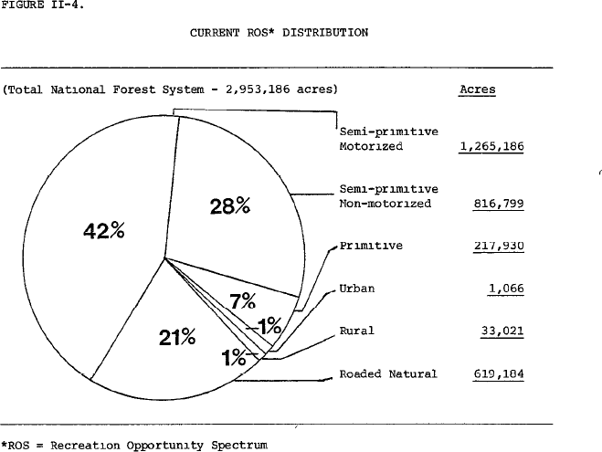
While there are reasons that ROS and existing management decisions could be legally changed on a local level on any forest, none of these reasons and analysis are discussed in the Proposal on even a site-specific basis. Rather the Proposal provides that a 24% change in management has occurred simply due to erosion of the NEPA based decisions made in the 1983 RMP and subsequently. The significant impacts to multiple use access from this erosion is outlined in table 146 of the DEIS as follows:
| Summer ROS – Existing
inventory |
Primitive | Semi Primitive Non-motorized | Semi Primitive Motorized | Roaded Natural | Rural |
| 1991 GMUG
Supplement (1983 allocation) |
217,900 | 816,800 | 1,265,200 | 619,200 | 33,000 |
| Current
management |
435,000 | 1,338,400 | 767,800 | 415,300 | 9,000 |
| Change as % of
forest acreage |
+7% | +18% | -18% | -7% | -.8% |
| % Change to
Original |
+100% | +64% | -39% | -33% | -73% |
The 1983 RMP clearly identifies that 64% of forest was motorized open in some capacity to motorized usage when the detailed EIS for development of the 1983 RMP is reviewed. The Proposal simply asserts that this has changed due to the 1991 GMUG RMP supplement and we must assume we are supposed to accept this access and NEPA has simply eroded to 40% of the forest without detailed explanation. This assertion is impossible to accept at any time and represents a management model that would simply render the entire NEPA process void if allowed to move forward. This is the type of management model that the NEPA process was put in place to avoid.
Not only is this position legally insufficient, the factual basis is severely lacking as well. Three general assertions are made for this management change, covering 5 pages of the EIS, and the reasoning for these changes is simply incorrect and offensive to the partnerships that the motorized community has worked hard to establish on the GMUG. The first reason for this 24% reduction in access is due to mapping, which is specifically addressed as follows:
“One difference is simply that the modeling techniques used were completely different, and the newer models use three-dimensional topography and different buffering techniques, so comparison is simply not one-to-one. Old, locatable maps from the 1991 inventory are sheets of mylar that were estimated with a wheel but never incorporated into the corporate data systems of new.”11
This assertion is offensive to the basic reality of levels of utilization of existing management designations, the Organizations are not going to dignify it with a substantive response. 24% of the GMUG management area designations have been changed and that is simply not a mapping error. Management designations are management designations and inventories are inventories and these classes of information should not be overlapped as they are factually and legally different.
The second reason is also inaccurate and flies in the face of basic NEPA processes as it asserts the 1991 Timber Supplement to the RMP granted unfettered access to managers to amend the RMP in any manner they found necessary. This explanation is a prime example of how the ROS inventory is portrayed as a management decision rather than an inventory tool. The Proposal summarizes this reason as follows:
“Beyond mapping techniques, however, much of the shift in acreages between inventories can be explained because the 1991 forest plan contains a lack of management direction to maintain desired summer recreation opportunity spectrum classes on the majority of the GMUG. Rather than plan direction shaping allocations as they have formed over the life of the plan, project-level decisions such as travel management analyses have shifted recreation opportunity spectrum allocations in the absence of any firm guidance.”12
This analysis is again a comical misrepresentation of the limited scope of 1991 RMP Timber Supplement, which is clearly stated in the 1991 Supplemental Amendment of RMP as follows:
“The enclosed Final Supplemental Environmental Impact Statement (FSEIS) and the accompanying significant amendment deal with timber management Issues. Changes in management of other resources such as recreation or wildlife are not proposed.”13
The anticipated impacts on existing ROS decisions for recreational access are specifically addressed in the 1991 Timber Supplement as follows:
“Each management activity, specifically timber management and road construction projects, would be planned and designed to meet the physical setting criteria for each Recreation Opportunity Spectrum Class and its associated Visual Quality Objectives. Each management activity would conform to the Standards and Guidelines.”14
Given that the 1991 Timber Supplement specifically states that planners are not changing any recreational access, any assertion that the Timber Supplement allowed wholesale changes without NEPA analysis lacks any basis in fact or reality. Planners clearly provide the affirmative statement that recreational decisions will continue to be governed by existing ROS requirements and existing management decisions and designations. Given these clear and unequivocal statements about access, existing management and ROS decisions, the Organizations cannot envision any actual basis for changing the allocations of recreational opportunities from the 1983 requirements. The 1991 Supplemental clearly states 1983 management decisions and ROS requirements are carried forward unchanged for recreation. The 1983 RMP ROS allocation of the GMUG are clearly provided as follows15:
We agree with the Proposal that at any point any land manager could alter a forest plan or travel plan in any way, but we must disagree that the 1993 Timber Supplement created this ability. The wide range of planning regulations have provided this authority for decades such as the National Forest Management Act. The NEPA process specifically requires a detailed statement of high- quality information on this decision-making process must be provided. Merely recognizing statutory authority is not compliance with NEPA.
The third reason provided for the 24% reduction in access between 1991 and the current time is such a completely twisted interpretation of the Travel Management process that again we are dumbfounded. This reason is summarized as follows:
“Additionally, major policy changes occurred with the 2005 Travel Management Rule, which forced the agency to look at site-specific, motorized routes and whether they were a part of the GMUG’s desired network of sustainable routes. When the 1991 forest plan was written, the Forest Service still allowed activities like cross-country travel, but after the 2005 Travel Management Rule was in effect, the agency eliminated many motorized routes and areas from public use. Certain areas were closed that were once open to cross-country travel, administrative routes such as timber roads that were once open to the public were gated, certain trails were converted to non-motorized trails, and if a route was unsustainable, such as an eroding trail traveling straight up a fall line or a user- created trail through a riparian zone, it was closed. All of these actions were compliant with forest plan direction, regulations, and policy; however, when those locations are modeled contemporaneously, the result is a shift from roaded natural and semi-primitive motorized to semi-primitive non-motorized on the recreation opportunity spectrum in the newer inventories.”16
Again, this is an example of the failure of planners to accurately summarize the GMUG planning or the National Travel Management Rule. The GMUG was one of the first forests in the country to adopt some type of travel management. The Organizations have submitted travel maps from 1993 that clearly identify that the GMUG was managed under a landscape model of open, restricted or closed at that time. Rather than being the major policy change that the planners are asserting, the 2005 Travel Management Rule clearly states that existing travel management decisions should be treated as follows:
“Nothing in this final rule requires reconsideration of any previous administrative decisions that allow, restrict, or prohibit motor vehicle use on NFS roads and NFS trails or in areas on NFS lands and that were made under other authorities, including decisions made in land management plans and travel plans. The final rule adds a new paragraph (b) to §212.50 to clarify that these decisions may be incorporated into designations made pursuant to this final rule.17
Given that the 2005 Travel Rule specifically states existing decisions can come forward without revision, and there has not been any travel plans updated outside the Gunnison Basin plan in 2012, we must question why there was thought to be any impact on the decisions predating the 2005 Rule. Restricted to designated routes did not change as a management category and Wilderness areas still remained closed.
This summary of the Travel Management Rule is such a completely twisted summary of the Travel Management Rule it is astonishing as at no point have any of the travel plans created on the GMUG been presented in combination with an RMP amendment. Not only would the automatic alteration of RMP management designations probably be an illegal interpretation of the Travel Management Rule generally, this position utterly ignores the large number of travel planning efforts on the GMUG that have been undertaken and chosen to NOT amend the Forest Plan prior to 2005. The Travel Management Rule and Resource Management planning efforts are entirely separate processes, and we have never heard a summary of these efforts such as that above. Designation of a route NEVER automatically change the management designations of any area. If an area is open to motorized access, it remains open to motorized access pursuant to the RMP qualifications, such as seasonal closures or other restrictions. Decisions such as travel management could also choose to undertake an RMP revision as part of the travel process. Such a decision would simply require more detailed and extensive NEPA analysis for the decision. That analysis has never happened.
Not only is the above statement a comically inaccurate summary of the Travel Management Rule, it is not supported in any manner by large scale travel management efforts that have occurred on the GMUG forest. We are not aware of any combined RMP revision and Travel Plan that addressed significant portions of the forest. Directly to the contrary this type of combined decision making, 2002 GMUG undertook a complete travel management plan for the Uncompahgre Forest. This extensive analysis again clearly stated the travel plan relationship to the existing Resource Management Plan for the forest as follows:
“Restriction on use and management necessary to attain certain ROS Class categories, such as Semi-Primitive Motorized or Semi-Primitive Non-Motorized would essentially impose new Forest Plan level direction, and would be significant in terms of the effects on the Forest Plan. The analysis and decision process that would be required to undertake such a change goes far beyond the scope of this Travel Planning process, and hence I deferred making the ROS decision here. That is better addressed in the upcoming Forest Plan Revision.”18
Similar clear and unequivocal statements of the scope of the 2002 Uncompahgre Travel Planning efforts are printed on each map that was provided to the public at this time. This notice states as follows:
“Recreational opportunity spectrum (ROS) as portrayed on this map represents the ROS which would be the consequences of this alternative, if travel were the only determinant of ROS. ROS is not part of the travel management decision that will be made based on the DEIS.” 19
Given the clear and unequivocal position of the Forest that ROS changes are to be undertaken in the RMP revision process and are outside the scope of the Travel Management Planning process for the Forest, we must question how there has been a massive reallocation of these designations on the GMUG since this time. We are also very concerned that all these changes have been undertaken without NEPA and are now merely being passed off as current management. ROS should not change on portions of the forest that were already closed to motorized or managed as restricted to designated routes.
Similar sentiments regarding the scope of Travel management remaining within existing management were also clearly stated in the 2010 Gunnison Combined TMP as follows:
“This decision is consistent with the Grand Mesa, Uncompahgre, and Gunnison National Forest Land and Resource Management Plan (1983 as amended in 1991 and 1993). This decision does not require any amendments to that plan in order to implement the designations and produce an MVUM for the Gunnison National Forest”20
Given that these management designation decisions have been made for 24% of the GMUG without NEPA analysis, we vigorously assert these decisions must be analyzed under NEPA and do not reflect current management in any way. The rationale for these decisions is astonishingly incomplete and fails to provide any information for the Organizations or motorized community as a whole could possibly provide a substantive comment on. Management areas are management areas and inventories are merely inventories and these are entirely different processes and decisions and should remain so.
First possible resolution of comment #3 concerns.
The Organizations believe the only manner to meaningfully resolve issue 3 of the comments is to revise the draft RMP to address management designations and accurate information around levels of utilization of these areas and then allow public comment on this document. We believe after management decisions are reviewed, rather than highly subjective inventories, a draft revised plan should be released to the public for comment.
Second possible resolution of comment #3 concerns.
As the Organizations are unable to understand existing management and allocations to understand where trails are consistent with existing management and where they conflict, the Organizations believe there could be another resolution of this issue. Factually there are simply too many routes traversing areas where management may or may not be consistent with the trail location to list with any specificity. If such an inventory of routes was attempted, we are not optimistic the inventory would be accurate at any level and we don’t want to lose routes due to administrative oversights. This protection is comically important to our interests and hundreds of miles of existing routes are moved into areas that are no longer consistent with that usage. We have developed a list of site-specific routes in this situation in the comments subsequently but this is far from complete. Nationally recognized routes such as Black Bear, Imogene and far too many other routes to address in detail in these comments are in this situation and have been analyzed in site specific travel management. We vigorously assert this intent must be reflected in the RMP.
Throughout the presentations we continued to hear from USFS staff that there was no desire to close routes that cross areas of inconsistent management or designation, such as a motorized route that has been permitted in site specific NEPA in areas that are now semi primitive non-motorized. This desire is not stated in any manner in the Proposal and must be clearly and directly clarified at the landscape, as we are not confident in site specific efforts. While there are consistent challenges around ROS and management designations in the RMP, the Organizations are proposing to utilize the fact that every route on the GMUG has been through at least one round of travel management. Many have been through several rounds of travel management, which will allow us to conclude risk to resources from these routes is minimal at best.
As each route has been through travel management multiple times, we are asking that a management standard be created on the GMUG that clearly and directly provides routes with sufficient space to allow the route to exist regardless of ROS designation adjacent to the route. This corridor must be of sufficient size to allow continued use of the route and also provide flexibility for issues such as mapping issues, short distance realignments that might have been undertaken to protect resources in the area and other management flexibility. The Organizations are aware that numerous forests, such as the GMUG have sought to place corridors around trails such as the CDNST and numerous forests, such as the Inyo in California, have placed similar corridors around the PCT. While we have generally opposed these corridors, it is important to understand our opposition to these corridors was not based on the corridor concept but rather came from the fact that the Corridor conflicted with statutory protected usages on the trail and conflicted with existing management. Our request here is very different as we are asking for a corridor that protects legal usages that have been reviewed multiple times from the application of management standards that are unrelated to the trail.
3(c). Winter ROS and usage data is horribly incomplete and decisions on this issue must be postponed until sufficient accurate information can be obtained.
The Organizations are also very concerned that the current ROS data is totally lacking around winter motorized usage as well and we are very concerned this usage has been a major topic of discussion on calls and virtual meetings. Almost as much concern has been raised from the non- motorized community as the motorized community on the inaccuracy of data that is currently available. We believe ROS data is worse for winter usages than summer. Again, we have heard from managers that they do not want to close existing areas and that decisions like that are outside the scope of the Proposal.
While this issue is an important concern for the snowmobile community, we are not confident that most CSA members even understand what the problem is or why it is an issue despite our best efforts. This is a major concern as most commonly our members’ response has been something to the effect that ROS should not matter, we did travel management for the area. Many other members are simply scrambling to get groomers functioning for the upcoming season and are not concerned simply because there has not been a lot of conflict on the GMUG around winter access for a long time. Obtaining and reviewing access data is simply an overwhelming task on a forest the size of the GMUG for just winter recreation and simply cannot be accomplished in the 90-day time frame for a public comment.
Resolution of issue 3c.
Any winter ROS or travel analysis be postponed until winter travel management in that area is updated or undertaken. This will allow far more meaningful engagement of the public on a much smaller geographic scale and generate a far better result. Again, the Organizations are requesting this postponement as the GMUG has already gone through several rounds of winter travel management and we are not aware of major impacts to any resource from winter travel management as it is currently managed.
4(a). The 3.1 management designation of “Colorado Roadless Area” attempts to manage local decisions based a national inventory process of limited factors which simply confuses the public.
The first utterly confounding issue on Roadless Area management is how was the decision made to designate the 3.1 management area in the Proposal as a “Colorado Roadless Area.” If the goal of this decision was to completely confuse and confound the public and preclude meaningful comment on this issue, that goal has been completely achieved. The Organizations must also question why an association of any management area to one of the most litigated concepts ever created in Forest Planning was thought to be a positive. For purposes of our comments, we will refer to the Colorado Rule as the “Colorado Roadless Rule” and the proposed management area designation as the “3.1 Management Designation.” The fact that the public has to start with such basic information and decisions in the hope of making comments understandable to the forest is an indication of serious problems with the Proposal.
Not only is the name one of the worst we have encountered, the Organizations have no idea how you manage an area to an inventory process that only dealt with a limited number of activities in the areas and clearly and repeatedly stated it was not a management designation. The Colorado Roadless Rule provides guidance on management that might impair these characteristics when these areas are identified, such as precluding road construction but allowing trail construction of all kinds if consistent with management decisions for the area. This would only seem to invite litigation of the Proposal rather than avoid challenges.
The 3.1 Management Designation is described in the Proposal as follows:
“Colorado Roadless Areas – MA 3.1 (CRA)
Management within Colorado roadless areas will be consistent with the Colorado Roadless Rule, 36 CFR 294 Subpart D – Colorado Roadless Area Management Desired Conditions
MA-DC-CRA-01: Colorado roadless areas encompass large, relatively undeveloped landscapes characterized by high-quality soil, water, and air that provide drinking water, habitat for diverse plant and animal communities, outstanding backcountry recreational experiences and high-quality scenery, and other roadless area characteristics, as defined at 36 CFR 294.41. Natural processes within the context of the natural range of variation (insects, disease, and fire) occur with minimal human intervention.”21
The direct conflict of this management standard is immediately apparent when the National Roadless Rule scope is reviewed. This scope specifically states why the Roadless Rule exists and the limited scope of any Roadless effort as follows:
“This final rule prohibits road construction, reconstruction, and timber harvest in inventoried roadless areas because they have the greatest likelihood of altering and fragmenting landscapes, resulting in immediate, long-term loss of roadless area values and characteristics. Although other activities may also compromise roadless area values, they resist analysis at the national level and are best reviewed through local land management planning. Additionally, the size of the existing forest road system and attendant budget constraints prevent the agency from managing its road system to the safety and environmental standards to which it was built. Finally, national concern over roadless area management continues to generate controversy, including costly and time-consuming appeals and litigation (FEIS Vol. 1, 1– 16 to 1–17). This final rule addresses these needs in the context of a national rulemaking.”22
The FEIS prepared for the Colorado Roadless Rule clearly states that any Roadless Rule efforts are an inventory of specific characteristics of lands and provides general guidance for the management and protection of these characteristics. It is not a management decision or management designation, which is clearly stated in the Colorado Roadless Rule process as follows:
“Forest plans contain forest-wide direction, as well as direction specific to each allocated management area. Management area direction typically defines management practices and land uses to be emphasized on NFS lands within that management area, as well as the activities that are limited or prohibited within the area.…. The inventoried roadless areas (IRAs) and Colorado roadless areas (CRAs) overlap many different management areas, and management area allocations are variable among the forest plans.”23
The need for subsequent management decision making in any area having Roadless characteristics is clearly stated as follows:
“Decisions concerning the management or status of motorized and non-motorized trails within Colorado Roadless Areas under this subpart shall be made during the applicable forest travel management processes.”24
Roadless areas rules are not a management decision but rather an inventory of the characteristics of these areas. Why that line would ever be blurred is confounding and must be corrected as the current model completely precludes meaningfully comment on any aspect of the CRA rule application or the application of the 3.1 management area designation. In addition to the confusion of the public on this issue, the Organizations must question why alignment with one of the most litigated forest management issues ever was thought to be a positive.
4(c) The Colorado Roadless Rule application is woefully incomplete in the 3.1 Management area.
The Organizations are also very concerned about the application of the Colorado Roadless Rule in this decision-making environment and how this major rulemaking was integrated into the analysis of current management and the range of alternatives provided in the GMUG proposal. The application of the Colorado Roadless Rule was a major concern in our previous comments on Wilderness Inventories and the planning effort more generally. This concern was raised with the GMUG staff in a phone call earlier this month and avoided completely with an assertion that these Roadless area decisions were put in the right category.
The Final Colorado Roadless Rule decision identified 901,100 acres of suitable roadless areas on the GMUG and also removed 281,500 acres of lands no longer having the required characteristics and added another 124,200 acres that had gained this characteristic when compared to the 2001 National Roadless Rule inventory. 25 While the Colorado Roadless Rule clearly identifies the scope of the inventory on the GMUG, this is no way correlates to the 3.1 Management designation boundary which the Proposal summaries as follows26:

The Organizations are simply unable to comment on the decision-making process that altered the current inventory so completely as this information simply is not provided in any way in the Proposal. This is simply unacceptable.
In addition to significant changes in Roadless area boundaries on the GMUG, the Colorado Roadless Rule introduced the concept of two levels of characteristics to be inventoried. These are identified as “Colorado Roadless Area” and “Upper Tier” and they are significantly different in terms of actions inventoried and those that are prohibited. Despite these significantly different inventory classes, Colorado Roadless areas and Upper Tier roadless areas management is not discussed in the EIS in any manner. Rather the Proposal seeks to take a multiple layer inventory process and manage it as a single management standard, which is the 3.1 Management Area. This is simply unacceptable.
In the development of the upper tier and Colorado Roadless area designations several characteristics were addressed in significantly different manners in the EIS and the scope of how these characteristics were found suitable was a major topic of discussion. The GMUG Alternative 2 of the Colorado Roadless Rule identified 130,300 acres as suitable for upper tier designation. In Alternative 4 of the Colorado Roadless Rule this acreage jumped to 544,900.27
There is simply no discussion of how decisions are consistent with inventory and analysis of areas for possible management in alignment with these characteristics of a roadless area or upper tier area. The words “Upper Tier” or “Colorado Roadless area” simply are not addressed in the Proposal outside the Wilderness inventory. In this discussion, USFS staff simply said these designations were put in the right category. After the concerns above on existing management identified above, we have no idea how this could be justified. We again have serious concerns on how those decisions were made and impacts this may or may not have on decisions such as route density etc.
Proposed resolution of issue 4.
The Organizations would ask that the name of the management area be changed to something other than a Roadless area, simply to avoid confusion of the public moving forward. Roadless areas are an inventory of limited characteristics of an area and not a management standard and this clear distinction should remain. Additionally, the Organizations would request that additional usages, such as grazing or oil and gas management of these areas be addressed simply to avoid confusion and conflict moving forward.
5(a) Our partnerships on wildlife challenges are significant and represent an issue we take very seriously.
Prior to addressing this concern, the Organizations believe it is important for planners to understand our position on and support for wildlife management in the State of Colorado. As we have noted throughout these comments, we have worked hard to partner with the USFS to address wildlife concerns in travel management on the forest. After all the years of collaboration and support for wildlife management, it is troubling to see basic facts and information be so inaccurately represented in any document. There is good information available on many of these issues and it should be used. This is only the tip of our efforts and we would like to highlight these partnerships as well.
- We printed 300 copies of the 2013 Lynx Conservation Assessment and Strategy and shipped them to almost every ranger district and field office in the state. This resulted from budget issues in the collaborative efforts and the inability of the USFWS to cover these
- We vigorously supported the ground breaking work involving the radio collaring of lynx and snowmobilers and other recreational users to allow far greater levels of understanding of the response of lynx to recreational 28 This included providing fuel, oil and equipment recovery when researchers became stuck in the backcountry and educating users to build better understanding and engagement of users in the study.
- CSA actually attempted to provide equipment (snowmobile) to wildlife researchers but was unable to arrange the documentation on the unit as it needed to be returned to CSA when research was
- The motorized community has worked hard to prepare highly credible resources for management of species and habitat, such as the CPW Trails and Wildlife Guide, in the hope of avoiding issues such as we now
Generally, we have focused on developing high quality, published and peer reviewed research to address gaps in existing knowledge to clearly and completely understand what the true challenge is to the species and how it can be addressed. As a result, getting the best information and science on an issue is of significant importance to us as we probably helped develop some of it. Again, it is highly frustrating when information is not accurately summarized, as we are not talking about a rounding error or mapping issue in the following sections. This is a material misrepresentation of information to the USFS by parties.
The Organizations would also like to state that if we could simply designate wildlife habitat in the manner that is proposed in the landscape level planning efforts and exclude the rest of the forest from wildlife analysis in subsequent planning that type of concept might be appealing just because of the efficiency that it could create. Unfortunately, this is not how wildlife management functions on the ground. This model is a double loss for the recreational community as large tracts of areas are functionally lost for future development of almost any level of recreational opportunity, despite most of these areas not being critical habitat for any species and wildlife concerns will continue to be major planning hurdles on the rest of the forest.
5(b). Ungulate population are above goals and steady on the GMUG which does not support claims made in RMP or moving to a draconian route density only analysis methodology.
As noted above, the Organizations actively seek out high quality and accurate data on wildlife issues and other challenges, as this is critical to balancing uses and reducing impacts and developing sustainable populations of a species in collaboration with recreational usage of public lands. The Organizations are very concerned about the recommended scale of acres to be managed as Wildlife Areas in the range of alternatives and regarding the onerous management standards that are proposed to be applied for these areas. We are very concerned that most of the proposed Wildlife area management is not habitat for the species. The Organizations believe these draconian management standards could be the single largest barrier to the thoughtful expansion of recreational access for all uses in subsequent site specific NEPA.
Prior to addressing the draconian nature of the route density standards that are proposed, the Organizations would like to address two foundational wildlife questions on the GMUG, which are:
- What is the current wildlife situation in the forest based on published peer reviewed science?
- What are the legal requirements for the designation and management of wildlife habitat?
The critical need to manage based on credible science and analysis on the GMUG has always been an important starting point for any discussions. The Organizations have spent years of effort working with GMUG and CPW planners to address wildlife-based concerns in site specific and forest level planning under a never-ending assertion that populations are plummeting and habitat is being overrun by recreation. We would be remiss if the similarity of the management position around the Proposal and these historical assertions were not recognized. It is also unfortunate that on many occasions we have not seen consistent positions being taken by partners regarding data and we have participated in numerous efforts where partner positions expressed behind closed doors often directly conflict with published and peer reviewed data on the issue made available to the public.
It is unfortunate that again we are planning in a climate where assertions on populations are not aligning with site specific information on the forest or landscape level reports such as the 2021 CPW Wildlife Winter Range and Corridors report. This type of inconsistency appears to be all too common on the GMUG and has also been woven throughout so many local collaboratives it simply defies discussion. CPW published and peer reviewed data specifically finds that populations have been steady and slightly increasing over the life of the RMP on almost every unit on the forest. As we note later, some of the current management has been so effective as to require CPW to actively reduce herd size through massive expansion of the number of hunting tags issued in the area. Based on wildlife counts for several species on the GMUG, existing management efforts have been HUGELY effective and the Organizations assert this is a HUGE win that must be recognized in the draft. Unfortunately, this win of current management is never mentioned in the Draft, but rather the Draft starts from a position that there has been a massive decline in species populations on the GMUG, without explanation. It is also unfortunate that previous CPW management to reduce over populations is now asserted to be the basis for expanded closures of recreational access to restore populations to levels CPW has already said are unsustainable.
GMUG has undergone extensive travel management over the life of RMP and there is simply no relationship between the travel management decisions and significant increases in species populations on the forest. Rather CPW data indicates that populations of elk have been strong and often consistently above population goals both before and after implementation of these travel plans in the early to mid -2000s. This data clearly shows at best a weak relationship between trails and wildlife populations as there have been significant decreases in trail mileage on the GMUG as a result of travel management, but the wildlife populations remain only slightly increasing or steady.
The Organizations have not addressed specific information from every elk management unit on the GMUG but have tried to give a sampling of the information that has been provided by CPW regarding these populations. From our review, these conclusions appear to be largely consistent regardless of the unit being reviewed. A sample of the long-term stability of herd populations on the GMUG is provided below:
The CPW E-14 herd management history provides the following graphical information:
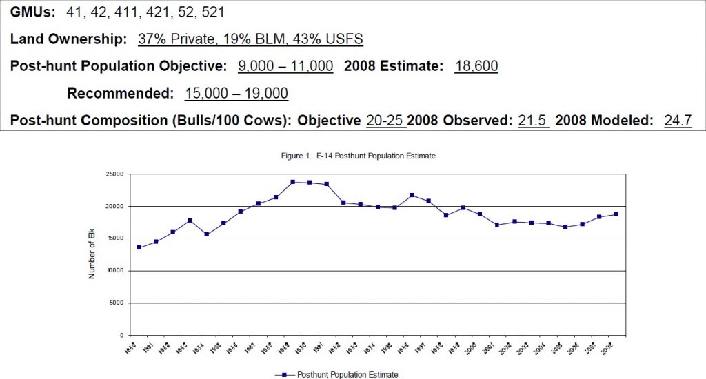
The CPW E-20 herd management history provides the following information:
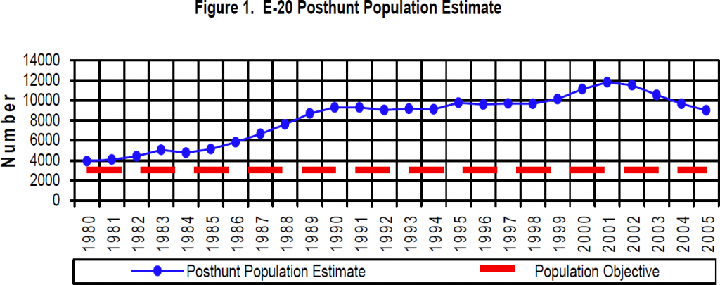
The CPW E-35 herd management history provides the following graphical information:
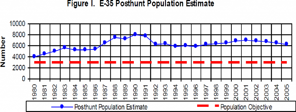
The GMU 41 Elk plan provides the following written summary:
“The 1999 elk age and sex composition survey for DAU E-43 resulted in a count of 4,580 animals. This is about 1580 elk above the current long-term objective of 3,000. For the same time period, the model (POPII) that was being used to predict population size for the DAU estimated a total population of 2,760 elk…. Elk numbers in the Fossil Ridge DAU increased from around 4,500 animals in 1980 to a high of 7,200 in 1989. With increasing numbers of antlerless licenses being issued each year, the population has been on a steady decline ever since. The 1999 post-hunt population estimate is 4580 elk. The mean population size during the past 5 years (1995-1999) is about 4840 elk.”29
The GMU 24 elk management plan provides the following written information: 30
Executive Summary
GMUs: 70, 71, 72, 73, and 711
Land Ownership: 30% private, 27% BLM, 25% USFS, 15% Ute Mountain Ute Reservation, 2% National Park, and 2% State
Post hunt Population:
2018 Modeled Estimate: 19,100 elk
Current Objective (2020): 21,000 – 24,000 elk
It is significant to note that while this unit might appear to be slightly under target populations, this is only the result of the population goal for the G24 Unit being increased by 3,000 elk in September of 2020.31
The deer populations have experienced significant fluctuations in populations over the life of the RMP. CPW attributes these fluctuations to many factors, such as a historic overpopulation of deer in the forest and severe winters. As part of the 2020 CPW report to the Western Association of Fish and Wildlife Services, CPW has directly attributed population declines to severe weather impacts on mule deer as follows:
“In 2019, 25 of 54 (47%) deer DAUs are below their population objective ranges. After large deer population declines from several severe winters, the total deer population has averaged 420,000 over the last 10 years. Population objectives that are appreciably higher than population estimates reflect Colorado Parks and Wildlife’s desire to stabilize, sustain, and increase deer populations.” 32
Throughout the report almost every other of the 22 state and province reports identified similar concerns and impacts to deer populations from heavy snowfall events. This relationship appears to be accurate for herds on the GMUG planning area, as hard winters have taken a heavy toll on deer population in the planning areas.
The D25 Deer plan provides the following graphical estimate for population goals on the forest33:
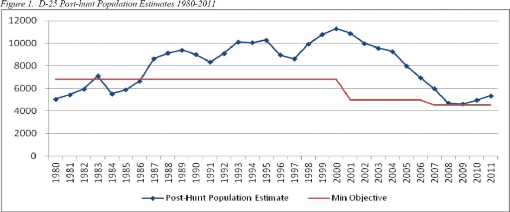
The D25 unit plan also provides a rather detailed corollary of the population in the planning area in relation to hunting licenses and depth of snowfall. This is another unit where deer populations were significantly reduced as a result of increased numbers of hunting tags being released to the public in the unit, which is again highlighted in the plan. 34
Unit D13 plan provides as follows:
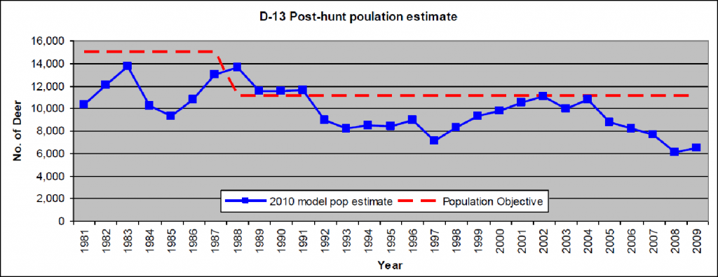
Unit D13 provides a very detailed discussion on how the explosion of private land development in the planning area has negatively impacted the herd in that area. We would note that private land development is really outside the scope of the planning effort, and are aware closing public lands will not result in private land development in winter range returning. That is simply outside the scope of any RMP.
D53
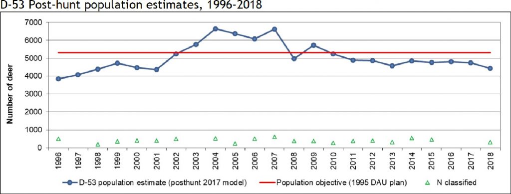
D-53 plan notes that there was a significant decline in populations of deer on the unit after CPW significantly increased the number of licenses available in 2006. 35
Areas on the GMUG have been particularly hard hit by unusually deep snowfalls. CPW had to feed deer in the winter of 2008 due to exceptional snowfall. 36 Best available science also concludes deer are more susceptible to impacts from snow and drought than other species due to smaller bodies. 37 Given the wide range of challenges that may be impacting the species, the Organizations must question how route densities would be thought to be a management priority as the primary threats are weather related as CPW has consistently and repeatedly stated in local and state level planning effort. The Organizations would note that some of the most immediate population declines have resulted from increased license sales for the species. We support hunting both as a recreational opportunity and as a management tool, but we are concerned that impacts of hunting have been the most direct to negatively impact populations but are never discussed. Even with the significant impacts from hunting and management, deer populations in the GMUG planning area are only estimated to be 10% below goals.
5(c)(1). Elk populations on the GMUG are 35% above goals making us question any asserted lack of habitat in the forest.
As noted above, the ungulate populations on the GMUG are generally stable and increasing in many areas. It is interesting to note that CPW estimates a sustainable population of 49,800 elk on the GMUG and identifies a population currently of 66,700 or 35% above population goals. For deer in the same geographic areas, the population goal is 82,150 with an actual population of 74,000 or 10% below population goals. Given the apparent huge success of elk populations in the same planning areas, where deer are experiencing a slight underperformance in populations the Organizations must question any assertion of a lack of suitable habitat in these areas.
The Organizations have created the following summary of Elk Management unit population goals and actual populations on the GMUG. We believe this isolated snapshot of the population of elk in the forest is as valuable as the long-term terms for the population as this information clearly established the success of habitat management on the GMUG.
Elk populations per GMU
| Elk GMU | Population target | Actual population | Relationship of target to actual |
| 5 | 6000 | 7000 | +17% |
| 14 | 11500 | 18600 | +62% |
| 15 | 4500 | 4500 | 0 |
| 16 | 5500 | 7100 | +29% |
| 17 | 3300 | 3300 | 0 |
| 20 | 9000 | 9700 | +8% |
| 25 | 4000 | 6000 | +50% |
| 35 | 3000 | 6000 | +50% |
| 43 | 3000 | 4580 | +53% |
| TOTAL | 49800 | 66780 | +35% |
In 2020 CPW provided a complete graphical summary of elk populations in the state based on 2018 numbers as follows:38
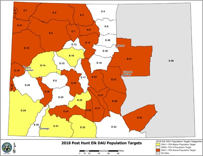
This graphic indicates that the strong elk populations continue to exist on most of the GMUG. We are providing this information to ensure that accurate high-quality information is relied on for the development of the Proposal.
Additionally, the Organizations also created the same chart for deer populations on the GMUG.
Deer populations per GMU
| Deer GMU | Population target | Actual population | Relationship of
target to actual |
| 12 | 20000 | 20000 | 0 |
| 13 | 8000 | 6400 | -20% |
| 15 | 7000 | 5600 | -20% |
| 21 | 5250 | 4400 | -16% |
| 22 | 5250 | 4400 | -16% |
| 24 | 17000 | 14500 | -14% |
| 25 | 5650 | 5300 | -6% |
| 51 | 9000 | 9000 | 0 |
| 53 | 5000 | 4400 | -12% |
| TOTAL | 82150 | 74000 | -10% |
While not as strong as elk populations on the GMUG, the deer population appears to be doing reasonably well. As we have noted previously these population variations have been attributed to severe winter conditions. Could we have too many elk and this is negatively impacting deer habitat? Maybe. Are there factors that are disproportionately impacting deer populations? Very possibly. In 2020, CPW also specifically identifies the numerous factors, most of which are totally unrelated to recreation that are impacting populations as follows39:
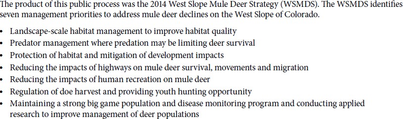
The CPW 2020 corridor and winter range report again highlight statewide deer populations as follows:
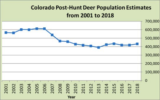
The Organizations do not contest that this is below the population goal for the state of 530-560k but it is steady and increasing slowly. It is interesting to note that the Corridor report specifically identifies hard winters of 2007/2008 as a major contributor to the population decline for deer at the state level.
The Organizations would also note that the deer populations in the GMUG planning area are trending much closer to their populations than herds in other portions of the state. We think this is a positive sign and indicates management is working. This represents another reason the Organizations are concerned about the imposition of draconian route density restriction as CPW has clearly and repeatedly identified that deer population decline is impacted by many factors. We are thrilled that deer and elk populations are strong and steady on the GMUG over the life of the RMP. This is thrilling and removes any need for draconian management standards such as those proposed.
5(c)(2) Troubling discussions on E25 populations.
As a result of the public meetings on the GMUG plan, the Organizations have engaged in discussions around wildlife populations on the GMUG and these discussions have consistently centered around one unit of the GMUG identified as E25. This Unit has consistently been used to rebut the forest level population totals that are referenced in the comments above. We have provided a copy of the email received in response to our questions to USFS staff outside this comment process to avoid any unnecessary impacts to relationships that clearly will be damaged by these actions. This discussion has become highly frustrating due to the lack of science basis but rather provides information presented in a manner scares the public into one conclusion. Too often existing populations and population goals are used interchangeably, which is an incorrect and pseudo-scientific process. This then requires the public to spend significantly more time researching the history of the unit and what is actually going on with the area. We are including this in our comments as we are encountering this tactic with all too much frequency.
First, we have to address the fact that we are discussing populations at the forest level and NOT a single GMU population. Given the fact that the GMUG planning area is almost 3 million acres, and most GMU are significantly smaller, this was the only way to accurately address the proper scale of effort. No single unit should be relied on for analysis of population trends in the forest.
Our first concern is that information was provided without any context, that is consistently provided, such as the relationship of the population in the planning area to the population goal that has been established for the area. This information was provided as follows:
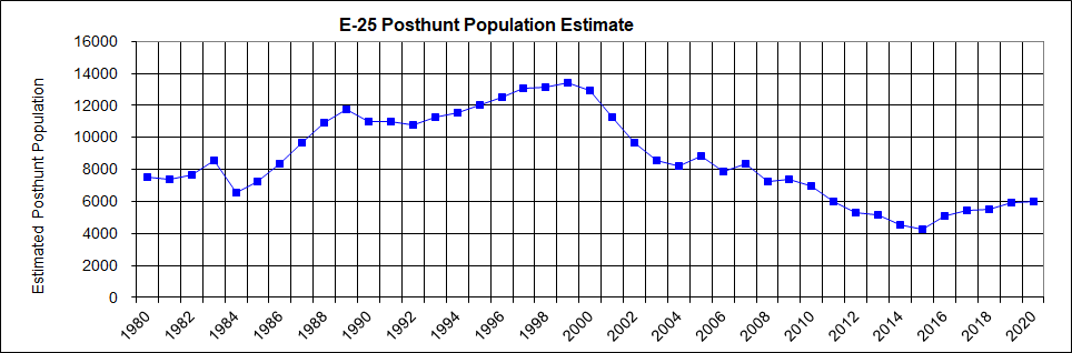
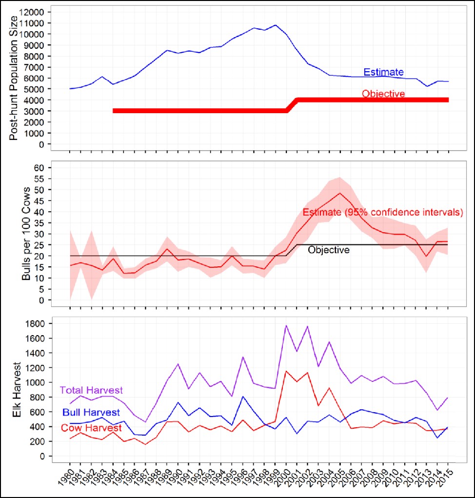
While this graph is alarming in isolation, concern wains when the target population for the area is included in the graph, which is clearly provided in the 2017 E25 Elk management plan on page 3 as follows:
The concerns are minimized by the factual baseline provided by the population goal in the area for the species. 6,000 elk is 50% above the 4,000 animal goal for the area. Obviously if the goal was 8,000 animals for the area there would be more concern but that concern is mitigated when the reasoning for the population decline is addressed. It is highly relevant that when the decision to reduce the herd population on this unit was made, the herd population objective was also brought up by 1000 elk. This is highly relevant information as the population has never come close to dropping below the new elevated goal.
What is further troubling on the E25 discussions is the fact that the population decline was the result of CPW management of the herd size, which is discussed in great detail in the 2017 herd management plan for the area.40 This discussion provides the following summary as follows:
“Post-hunt Population Size History
Examining the E25 herd retrospectively with the most current population model indicates that E25 experienced three major population trajectories since 1980:
- 1980 – 1999. During this period, the population slowly grew, more than doubling the initial 1980 estimate. An average of 337 cow elk were harvested annually, representing approximately 8% annual harvest of the population’s cow segment (pre-harvest annual estimates)
- 2000 – During the late 1990’s, E25, like elk populations statewide, was over-objective and considered over-abundant from a landscape health and rangeland conflict standpoint. In 2001, management of E25 changed in three ways. The first was to intentionally decrease the elk population size. The second was to raise the population objective size by 25% (3000 to 4000 elk). The third was the implementation of totally limited elk licenses to decrease hunter crowding. Given the published 1999 estimate of 7800 elk, the population objective (4000 elk) of the 2001 DAU plan was implemented to decrease the population size by nearly 50%. From 2000 to 2005, high harvest pressure was placed on cows. The primary method used to reduce the population was with a large allocation of either-sex licenses. Approximately 922 cow elk were harvested annually, representing a 21.7% annual harvest of the population’s cow segment (pre-harvest annual estimates).
- 2006 – 2015. In 2006, either-sex licenses were reduced to only archery season. Based on the published post-hunt population estimates and the corresponding DAU plan objectives, the reductions of the prior period had been met. Retrospectively, with the revised E25 population model provided in this plan, along with indexed objectives, it is further confirmed that the 2001 DAU plan population objective was reached. Population size was considered steady relative to the 1980–1999 and 2000–2005 It is uncertain whether current model projections of population size, given the recent license allocation strategy, is indicating a growing or decreasing population. Approximately 407 cow elk were harvested annually, representing 12.8% of the population’s cow segment.”41
The Organizations support wildlife management and are aware there are numerous reasons for herd sizes to be reduced. This was discussed in great detail in the 2017 Herd Plan and the 2001 Herd Plan for the area, so clearly this was not a decision taken lightly. We also don’t contest that this was a significant reduction in herd size in the area, which was done to reduce habitat impacts and improve hunter’s experiences but we also assert the why of the decision making is highly relevant input to this discussion that has simply been committed. This information is critically necessary to intelligent decision making and is all too often simply omitted. This is not ok.
We are deeply disappointed that this management action by CPW has never been discussed with USFS staff in the planning process. Rather this unit, despite the active management by CPW, is being used to represent the entire forest in a manner that in no way reflects the actual situation on the ground, which has been significantly altered by CPW actions. This is misleading at best and in no way reflects what is a major win for management on the forest as a whole. This is an example of a collaboration gone wrong and what must be avoided in the development of the RMP and any decisions moving forward. Decisions must be science based and fully researched rather than relying on faulted processes such as this.
Proposed resolution of Issue 5a and 5b.
Any decisions must be based on published peer reviewed data on the issue, and clearly this has not occurred on the GMUG to date with regard to much of the populations of wildlife. The Organizations vigorously assert that USFS staff must review basic information, such as population goals and actual populations of species on the forest, and craft management based on the actual peer reviewed and published information. This management information identifies that current management has provided a healthy and vibrant population of many species on the forest, as exemplified by the fact that the elk population is 35% above goals on the forest.
Any future management actions must be consistent with existing analysis that has been performed on the GMUG and new management resources such as the CPW Planning Trails with Wildlife; The CPW Wildlife Corridor report and new guidance from the USFS on wildlife and trails. We would welcome further discussions with USFS staff on options that might be available based on accurate science, but at this time we are unable to specify this management as it is not represented in any alternative of the RMP.
5(d) US Supreme Court Weyerhaeuser definition of habitat compared to simply drawing areas on maps.
Second foundational concern is a little frustrating to raise as this has been addressed previously in our comments, mainly the application of the unanimous US Supreme Court decision in the Weyerhaeuser matter. In Weyerhaeuser, the unanimous Supreme Court struck down habitat designations for the endangered dusky gopher frog in extensive areas that the species had not used in decades as habitat. It is important to note the parallels between the Weyerhaeuser fact pattern and the Proposal as both matters involved efforts by land managers to create or designate habitat in areas that the species does not currently use as habitat. The Supreme Court specifically held:
“Even if an area otherwise meets the statutory definition of unoccupied critical habitat because the Secretary finds the area essential for the conservation of the species, Section4(a)(3)(A)(i) does not authorize the Secretary to designate the area as critical habitat unless it is also habitat for the species.”42
The Weyerhaeuser decision directly addressed the question of what is wildlife habitat and fish and wildlife service has developed a definition of habitat as follows:
“Habitat contains food, water, cover or space that a species depends upon to carry out one or more of its life processes”
The Supreme Court and USFWS clearly state that merely having wildlife in the area does not make it habitat and that habitat is only areas that the species depends upon for survival. It is with this structure of analysis we are approaching the Proposal, and when the Proposal and these standards are compared, there are significant issues. The following chart provides a breakdown of the acreages of wildlife habitat areas that are designated in the Proposal43:
![]()
The Organizations submit the lack of factual basis for the designation of between 740.000 acres or 36,000 acres is immediately apparent. There is simply no way the habitat any species depends upon fluctuates in such a manner. As discussed in much greater detail in subsequent portions of these comments, CPW And USFS management standards for any species are only to be applied to winter range, calving areas and other areas of unusual significance to the species. We support this management and will continue to do so. However, these areas in no way reflect these types of habitat areas that species depend upon.
We are also concerned that these artificially drawn areas will not be the only areas of habitat on the GMUG as the wildlife will continue to use areas that they actually depend on regardless of where the lines are on the maps. We are also very concerned that proposed Wildlife areas in no way relate to the commercially available data and boundaries for the GMUG for many of the factors that both USFS and CPW have identified as important areas for protection.
Candidly, we have trouble understanding how roughly 25% of the GMUG has been identified as wildlife habitat when CPW has clearly identified far less as areas where species depend on the forest. The proposed 740,000 acres must be reviewed to ensure these are areas that the species depend upon.
Proposed resolution of issue 5b.
The Organizations welcome any effort that can be done to streamline wildlife management and analysis on the forest, but have serious concerns about the wildlife management standard as it does not relate to habitat on the ground in any way. Simply drawing lines on a map does not create wildlife habitat, but rather reflects the type of management that the US Supreme Court struck down in Weyerhaeuser.
Rather than streamlining wildlife reviews and protecting habitat, the wildlife management area designations compound this challenge as clearly wildlife habitat outside these areas on the map will still have to be taken into account in future planning regardless of the habitat is in the designation area or not. The proposed management designations simply tie land managers hands without creating significant benefit to the species.
5(e). Habitat is a multifaceted effort that is not reflected by simply mapping roads and trails.
The Organizations are very concerned that the Proposal starts from a position that the primary factor degrading wildlife habitat was trails and roads, which is in direct conflict with existing NEPA processes that have provided a steady and increasing population of species on the GMUG. Habitat effectiveness mapping has been highly effective in mapping sage grouse habitat. 44 We are unsure how this relationship was identified on the GMUG as best available science clearly concludes habitat is impacted by a wide range of factors, some of which are manmade and many of which are entirely natural. As we have noted above, significant changes to wildlife populations have occurred as a result of management efforts and context for that decision matters. Without context we could equally assert that populations decreased during times of travel management plans being implemented. Without context, this decision could be asserted to be accurate even though it is not, as the population declined while trails were being closed. The relevant factor in the habitat is the fact these were both management actions that were not related to each other, other than the fact they were occurring at the same time. Clearly elevating one factor and ignoring other factors can lead to bad management, and we would like to avoid this in the future as it makes no sense.
An issue that would represent a factor that degrades habitat and negatively impacts populations would be the reintroduction of the gray wolf, and these types of impacts would never be offset by closing routes. Many challenges like climate change are entirely unrelated to forest management decisions. Other challenges such as the pine beetle epidemic, wildfire impacts and flooding issues are entirely unrelated to road density. The Proposal is entirely silent on how the decision to move from habitat effectiveness to merely mapping route density was made and we believe lead some conclusions that simply cannot be supported. Based on the overweighting of roads as the sole factor, any area that has no roads such as Wilderness areas should be hugely effective as wildlife habitat. This is simply not the case as Wilderness areas are also some of the hardest hit areas from pine beetles and fire.
While the Proposal is entirely silent on how the decision was made to only address road density, CPW documentation from GMU in the GMUG planning area discusses the wide range of factors impacting habitat in great detail. This discussion is as follows:
“Elk utilize a range of habitats, depending on the season and conditions. Elk movement and subsequent distribution patterns are influenced by many factors, such as weather, vegetation (Lyon and Jenson 1980, Hurley and Sargeant 1991, Sawyer et al. 2007), and wild predators (Hebblewhite et al. 2005). A growing body of information also supports that elk habitat utilization is influenced by several anthropogenic factors, including: non-hunting recreation (Phillips and Alldredge 2000, Kloppers et al. 2005), hunting recreation (Walsh et al. 1991, Conner et al. 2001, Johnson et al. 2002, Viera et al. 2003, Sunde et al. 2009, Cleveland et al. 2011, Rumble et al. 2005), off-highway vehicle traffic (Preisler et al. 2006, Wisdom et al. 2005), road traffic (Perry and Overly 1977, Lyon 1979, Rost and Bailey 1979, Witmer and deCalesta 1985, Preisler et al. 2006, Sawyer et al. 2007, Montgomery et al. 2013), resort/residential development (Picton et al. 1980, Morrison et al. 1995, Wait and McNally 2004, Shively et al. 2005), and mineral extraction (Kuck et al. 1985, Webb et al. 2011). It appears that combinations of these anthropogenic and or natural factors produce a nonlinear habitat utilization response in elk (Frair et al. 2008). Support for some of these elk-habitat selection relationships (i.e., road impacts on elk movement) are currently being demonstrated in preliminary analysis of elk movements in the Gunnison Basin and West Elk Mountains (Appendix 3, section 6).45
CPW has also expressed similar concerns around deer populations and the effectiveness of deer habitat as follows:
“There hasn’t been any factor pinpointed for the decline and it is most likely caused by a combination of reasons related to habitat availability and condition.”46
The Organizations are aware that exceptionally complex models have been created to model the complexity of factors that will impact habitat effectiveness on a landscape.47 The Organizations have also vigorously supported the efforts of the USFS to more completely understand recreation, habitat and other factors that impact wildlife. The complexity of this relationship cannot be understated but can now be actively tracked and more completely understood by the real time comparison of wildlife and recreational users on the landscape as evidenced by the following maps48:
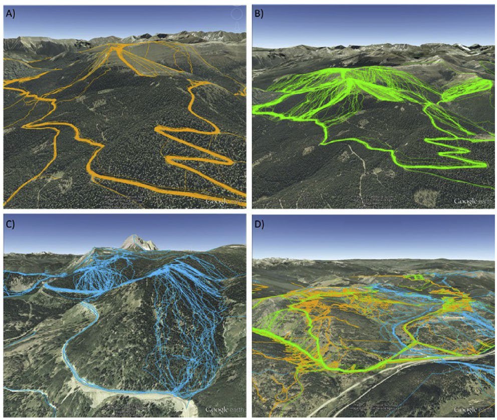
With data like the maps above, we simply must question why highly generalized landscape standards would be pursued instead of this highly detailed data that is already available. The immediate conflict of many of the landscape tools in the guide and management efforts from our federal partners is apparent as the US Fish and Wildlife Service has a 76-page manual available for development and management of roads in National Wildlife Preserves.49 The USDA Natural Resource Conservation Service also has extensive guidance on habitat mapping and the relationship of this to on the ground issues. A complete copy of chapter 5 of the NRCS guidance on mapping and recreation is attached as Exhibit “E”. Clearly the NRCS guidance is well beyond anything akin to mile-by-mile habitat analysis.
5(f)(1). Draconian trail density standards of one mile of trail per square mile is unprecedented and conflict with previous site specific NEPA analysis on the GMUG.
The Organizations must start our discussion on the inconsistency with what has been proposed in the RMP and what has resulted from travel management planning on each of the forests with a question. Why is there a perceived need to make large alterations to the existing travel management decisions with the adoption of route density standards and other exclusive use concepts in the alternative? Some of these travel management decisions were only recently completed and every one of which has been updated multiple times over the life of the old RMP, further calling into question many of these asserted needs to change.
The Organizations would note that many of the groups pushing for restrictive travel decisions are the same groups that pushed for large scale route closures in the previous rounds of travel management. The Organizations have sought balance and meaningful analysis of challenges and thoughtful responses in management that will address these issues on the GMUG since discussions on the plan started many years ago. The trail density standards that are proposed are another issue where we continue to seek meaningful analysis of information on challenges and topics but must question why this standard is thought to be needed after so many rounds of travel management decisions have provided decisions to the contrary. Our concerns on this issue are based on the immense conflict between the asserted need for these standards and the actual data on the issue. These two resources tell very different stories and fail to justify imposition of the draconian management standards that are proposed.
The existing RMP and travel management process has used a threshold of 1.9 miles of road per mile as a trigger for further analysis of any area of heightened management concern, and fails to actually require any management action specifically to allow for the other attributes of the habitat or watershed. This road density analysis is explained in high levels of detail in the site specific NEPA as follows:
“An evaluation of road densities, a measure of human activity that can impact water resources, in combination with watershed sensitivity, resulted in the identification of six sub-watersheds with high road densities (greater than 1.9 mile/square mile) within a Sensitivity Class 4 watershed (Table 3-7). These would be areas where the density of roads and trails could have a great influence on watershed function and could be a contributing factor to adverse water resource impacts (Figure 3-1).”50
The Gunnison TMP then proceeded through a detailed discussion of specific routes and specific impacts from those routes in each location that was above the recommended threshold of 1.9 miles of density. We question how with analysis of this specificity these watershed conclusions of the Gunnison TMP on route densities can simply be overruled.
The GMUG has also undertaken this type of highly detailed site specific NEPA on a wide range of issues for acceptable road densities based on site specific inventory and analysis. No specific species or issue identified areas where road densities were found acceptable was in compliance with the proposed 1 mile per mile of densities. The following chart provides a detailed breakdown of these conclusions of previous management:
| Species | Permitted Route Density |
| Greenback Cutthroat Trout51 | 4.78 |
| Water influenced zone52 | 4.569 |
| Sucker53 | 2.57 |
| Colorado River Cutthroat Trout54 | 2.17 |
| Canadian Lynx55 | 1.39 |
| Gunnison Sage Grouse – occupied56 | 2.1 |
| Gunnison Sage Grouse -unoccupied57 | 2.5 |
As a result of the above standards, we must question how the threshold of 1 mile per mile was found necessary to be an absolute standard rather than a threshold for further analysis and how was the standard found to be necessary for not only roads but also “roads and trails”. If this type of alteration of existing management is actually necessary, this should be the basis of extensive discussion and analysis, rather than the cursory assertions that are now present.
5(f)(2) The draconian mile per mile route density requirement conflicts with 2020 USFS guidance on recreation and wildlife.
As the Organizations have noted above, the populations of deer and elk on the GMUG are strong and steady, which we believe is an excellent starting point for discussion. Given this situation, the Organizations must question why so much of this proposal is in direct conflict with 2020 guidance on the relationship of trails and wildlife, which is summarized in the 2020 USFS entitled: “Sustaining Wildlife with Recreation on Public Lands: A Synthesis of Research Findings, Management Practices, and Research Needs”58. The 2020 USFS trails and wildlife guide starts with a clear recognition that trails often play a VERY minimal role in degrading habitat which is stated as follows:
“Although large highways and infrastructure associated with urban/ suburban areas have been found to alter ungulate migration patterns, outdoor recreation on public lands generally involves human developments at a small enough scale that disruption of major migration pathways (i.e., for larger terrestrial species) is generally not a concern (Alexander and Waters 2000 59
Habitat fragmentation occurs when contiguous habitats are divided into smaller, isolated fragments (Fahrig 2003), e.g., through construction of a road network to access public lands for recreation and other uses. Some species are sensitive to habitat fragmentation, such as large carnivores that may require a large area of continuous habitat, and habitat specialists (i.e., species that thrive only in a narrow range of environmental conditions), while other species are more tolerant of or even benefit from habitat fragmentation (Crooks 2002). Although the presence of low-density unpaved trails developed for recreation is not typically associated with habitat fragmentation for mid- to large-sized species, trails can fragment habitat for species with lower mobility, especially when trail density is high or when trails are wide and paved.”60
The 2020 USFS Guide then goes into a long discussion of specific species issues and studies and fails to recommend any standards such as route densities. Given the strong and steady population information that has been provided in great detail by CPW, the Organizations would question if most of the proposed management discussions have been resolved on the GMUG.
Rather than applying the highly detailed site and species-specific analysis that this identified as best available science by the USFS, the Proposal seeks to overturn the application of these standards previously completed on the GMUG and move to the overly broad management by landscape standards that the new USFS Guide recommends against. The success of existing management would seem to weigh heavily in continuing to manage the GMUG in a manner consistent with national guidance.
5(f)(3). The draconian 1 mile per mile of route density directly conflicts with CPW guidance issued in 2021 on this issue.
The Organizations are again starting a discussion with the statement that the balancing of recreation and conservation interests has been an issue the motorized community has spent significant efforts in collaboration. The most recent guidance that has been issued on this issue was the issuance of CPW’s “Planning Trails and Wildlife Guide” in 2021, which was the result of a multiyear collaborative effort of interests including USFS, BLM, CPW, US Park Service, US Fish and Wildlife Service and nine local communities from across the state. Over the multiyear planning effort, detailed public comment was received from almost 40 groups, including Backcountry Hunters and Anglers, The Wilderness Society and Great Old Broads for Wilderness. A complete copy of this document is attached to these comments as Exhibit “F”.
We are taking the position that this document is clearly the best available science on the trails and wildlife density standards issue and provides management guidance that directly conflicts with the direction being provided in the Proposal. Rather than supporting the proposed direction of management in the RMP, the CPW Guide outlines with great detail the site-specific management process and efforts that have already been undertaken on the GMUG. The similarity of the CPW guide and the new USFS guide cannot be overlooked. This document confirms why this management effort has been successful and why it should not be altered at the landscape level, but rather continues on a site-specific basis on an as needed basis.
Initially the CPW Trails and Wildlife Guide outlines a highly collaborative and highly detailed site- specific review of trails and wildlife issues that is very similar to the efforts that have been undertaken in the Travel Management processes on each of the forests on the GMUG. As a result, we must question why those efforts would not be highlighted as well ahead of their time and recognized as still being best available science on these types of issues. The recommended process for planning is outlined in the CPW Guide as follows:
- “FPs, TMPs, & RMPs identify current and future routes, trail uses, closures, and seasonal closures. These planning processes allow advocates to get involved in planning and designing quality trails and systems.
- FLMAs are required to go through the National Environmental Policy Act (NEPA) process prior to making decisions, which, in addition to habitat fragmentation, considers vegetation, soils, air and water quality, and cultural NEPA requires public comment and review opportunities.
- TMP development is a high priority for Many FLMAs have shifted from “open” unrestricted use of public lands to limiting motorized and mechanized travel to designated routes.
- Emphasize early stakeholder and public involvement in the NEPA and TMP processes for Federal lands (as well as state and local).
- TMPs on public lands that change strategies from an open system of travel to limited, generally reduce existing road and trail mileage significantly. New trails or networks located in less impactful areas may be proposed based on local needs with an emphasis on quality over ”61
The Organizations would be remiss if the CPW Guide starts any analysis of wildlife and trails with recognition of management efforts that are in place in any area. This continues to be a struggle for the GMUG planners in this effort as this has not been identified yet.
The CPW Guide recommends a highly site-specific analysis of routes and application of tools such as seasonal closure to reduce route density in sensitive wildlife areas during times such as calving or winter range usages. Again, we must stress this type of analysis has already been completed in travel management plans already finalized on the forest. These have been highly successful and the success of these efforts is highlighted throughout the more than 60 pages of analysis in the CPW Guide. The necessity of highly localized review of issues and challenges as part of this collaboration is specifically addressed on pg. 24 of the Guide CPW clearly identifies as follows:
“There are two important considerations to keep in mind with route density:
- Site-specific factors, such as topography, may influence the quality of habitat, and are not accounted for in the calculation for route
- Route density calculations do not necessarily account for how trails are spatially distributed across the landscape (Figure 6).”62
On page 27 of the CPW Guide, CPW specifically and clearly states their recommendation for management of priority habitat and the importance of timing restrictions to achieve these goals as follows:
- “Limit trail densities (including existing trails) to less than one linear mile of trail per total square mile, within production areas, migration corridors, and winter range habitats.
- For trails within production areas or winter range habitats, implement seasonal timing restrictions for all trail ”
Given that the CPW Trails and Wildlife Guide specifically identifies that tools such as seasonal closures should be used to bring seasonally used areas into compliance with general recommendations, we have to question why the blanket application of this mile for mile standard without seasonal closures is now asserted as best available science or even being necessary. The Organizations assert this type of analysis has already occurred on the GMUG and has been highly effective. If there was a desire to move to something more restrictive than best available science, this would have to be discussed in great detail and this has not occurred.
5(f)(4). CPW only recommends education of users to address recreational activity in Migration Corridors
In addition to the final release of the 2020 Trails and Wildlife Guide from CPW, CPW has also issued a detailed report on the management of wildlife corridors and winter range for wildlife in Colorado in 2020. The relationship of population development and expansion in Colorado and its possible impacts on wildlife migratory corridors has been another issue there has been a lot of vocal concern raised regarding. We have actually been told by several folks that migration corridors should not have trails of any kind in them and we have heard this repeatedly stated in public meetings on the GMUG. This is very concerning to us and as a result we are discussing this as well as noting its strategic alignment with the 2020 CPW Trails and Wildlife Guide.
The management of wildlife corridors was the basis for new peer reviewed published work from CPW in May of 2020 Entitled “2020 Status Report; Big Game Winter Range and Migration Corridors”. We have attached a complete copy of this new document as Exhibit “C” to these comments. This report goes into great detail regarding issues with winter range and high-speed arterial roads in migration corridors. The report also highlights the minimal threat that trails pose when compared to high-speed roads for quality of winter range and viability of migration corridors as the recommended management action for trails in these areas is as follows:
“CPW staff will continue working with trail users, NGOs, local municipalities, and other stakeholders to avoid, minimize, and mitigate negative effects from motorized recreation to big game and migration corridors. CPW will continue to educate recreationists regarding their impacts to wildlife and seek methods to effectively influence behavior of motorized trail users.”63
Again, it goes without saying that this CPW Trails and Wildlife management recommendation has largely been completed for motorized trails on the GMUG. Education of users falls well short of the draconian standard of one mile per mile in habitat areas that is being proposed. Again, we vigorously assert the Proposal must apply best available science on this issue.
5(g) The proposed route density standard conflicts with 2020 USFS Guidance documents on the trails and wildlife issues.
As the Organizations have noted previously, the Proposal route density limit conflicts with best available science from CPW on management of trails and wildlife. While the CPW documents have been in development, the USFS has also been creating new guidance documents on management of Trails and Wildlife. This culminated with the issuance of the USDA report entitled “Sustaining wildlife with recreation on public lands: A synthesis of research findings, management practice and research needs” in December of 2020.64
Again, the GMUG proposal fails to comply with this guidance document either as at no point does the USFS guide recommend anything similar to a general or landscape level analysis or standards, such as that proposed in the RMP. Rather the guide outlines the highly site-specific nature of the relationship between trails and wildlife. This report addresses issues on a species-by-species basis rather than the more topographically based manner used in the CPW Guide. The USFS report identifies general factors such as the difference in concerns when comparing a road to a trail, which is identified as follows:
“Although the presence of low-density unpaved trails developed for recreation is not typically associated with habitat fragmentation for mid- to large-sized species, trails can fragment habitat for species with lower mobility, especially when trail density is high or when trails are wide and paved.”65
New USFS wildlife and trails guide specifically states the highly variable nature of impacts along the scale from high-speed arterial roads to low-speed single track trails as follows:
“Although motorized activity can disrupt important migration corridors, note that this disruption is more strongly influenced by highway traffic than is typical of trail- based motorized recreation (Lendrum et al. 2013, Sawyer et al. 2012).”66
The USDA guide also notes the importance of seasonally used areas as follows:
“Because seasonal behaviors vary by species, the information provided here requires biological knowledge of local species of concern. As described above, the reproductive status of individuals influences the response of individuals and groups to recreational activity.”67
The Organizations again vigorously assert that the Proposal must align with best available science on trails and wildlife and this analysis has been outlined with a high level of detail by both the USFS and CPW. As we have noted before these processes apply highly site-specific analysis due to a wide range of factors, and this has already been completed on the GMUG and yields conclusions that are in conflict with the proposed mile per mile standard that is proposed. We have to ask why there would be a desire to change this as the change conflicts with Best Available Science and has been highly effective already. This is an issue we should be celebrating the success of rather than discussing how to start from the ground up.
5(h) Private lands impact on road density
As we have noted, the GMUG has performed a huge amount of site-specific analysis of wildlife habitat and routes in the area in the manner that is recommended in both USFS and CPW guidance documents. This topic was a significant concern and analysis in the Gunnison Basin Travel Management plan that was completed. 68 This type of analysis is exhibited in the specific route density calculations that are available for many species and priority management concerns that we have provided in these comments. As we have discussed more completely in other parts of these comments, in reviewing these documents, it is immediately clear these draconian route standards are not supported by site specific analysis.
This site-specific analysis identifies a host of site-specific issues that must be addressed in site specific issues such as how road density calculations are being provided on areas of lands where ownership of the square mile is both USFS and private. The Proposal fails to identify foundational standards for the implementation of the mile per mile standard. Basic questions that have been addressed in site specific analysis already completed on the forest are left open, such as what if roads are private and outside USFS management? How does route density work in transitional areas where private areas are highly developed? How does route density address issues such as the highly negative impacts of high-speed arterial roads when compared to almost non-existent impacts of low-speed arterial trails? These are foundational questions in any route density analysis and simply do not align themselves with any of the landscape type analysis that has been completed.
5(i). What are the population level impacts of high-speed arterial roads on wildlife?
The Organizations are aware that often maintaining a complete understanding of the comparative scale of threats and challenges that wildlife is facing can be difficult in the planning process. Throughout these comments, high speed arterial roads have been identified as the major concern for wildlife. While this is clear, the relationship to trails is difficult to understand. In our efforts on wildlife management, we participated in Western Governors Association meetings on wildlife concerns and in 2014 the Western Governors Association published landmark research on the actual impacts of high-speed roads on a 12.25 mile stretch of US 89 in Kane County Utah. A copy of this research is attached as Exhibit “G”. This research summarized the scope of the problem faced as follows:
“Along a stretch of highway in southern Utah, more than 100 mule deer were being lost every year to wildlife-vehicle collisions.”
After management of access points for deer on the road, the researchers published their conclusions as follows:
“It is estimated that a minimum of 102 accidents will be prevented each year through this collaborative effort.”69
The Organizations are including this research to allow managers to understand the scale of impacts that high speed roads can have on deer. Any assertion that every mile of trail on the GMUG could directly cause the death of 100 deer per year is simply comical. Clearly it is functionally impossible for any 12.25 mile of trails to cause this type of impact, which clearly identifies how much more significant this type of threat is to wildlife. While trails may be a threat to a specific animal at most, they simply are not even close to the level of impact that can result from high-speed arterial roads on a population of any animal.
The Organizations would vigorously support the development of management tools, such as those used in the Utah study, to actually protect wildlife, rather than taking largely token gestures to manage threats that have already been addressed on the GMGU. The Organizations would support efforts such as this.
5(j). ROS, Trail density and winter travel
We have had several discussions with the forest around trail density standards and the relationship of this standard to OSV recreation and the large open areas relied on for OSV recreation. We have repeatedly been told this standard is applying only to wheeled summer usage and was not designed for OSV planning in any manner. The Organizations completely agree with this position as there is no scientific basis for this type of analysis or standard with the use of OSV in the forest. This clarity MUST be reflected in the plan moving forward.
In addition, we are aware that winter ROS information that the forest has currently is very limited and often of questionable accuracy. While this is a major concern for the snowmobile community, addressing this issue on almost 3 million acres of the GMUG with any detail simply is not possible within the 90-day comment period that is currently available. The Organizations would request that in light of the limited information that is available, that any ROS decisions addressing winter travel be postponed until such a time as winter travel management is being undertaken on a more localized level. This would allow far more detailed and meaningful discussion to occur about winter travel and how it would be updated from current plans. This request is based on the fact that every forest on the GMUG has a winter travel management decision in place and they have been effective. We are aware that some of these plans are older, but we recommend updating these plans rather than trying to extend their life with poorly developed landscape analysis tools.
Resolution of Issue 5.
The Organizations would submit that habitat effectiveness is a far superior management tool on the forest, given the hugely successful track record it has on creating stable and increasing populations on the GMUG. Arbitrarily applying a route density standard is a poor substitute for the habitat effectiveness standard. The Organizations request that if route density standards are used, they reflect actual standards on the ground that the USFS has created and they are consistent with best available science from CPW and USFS guidance on trail issues.
The GMUG has been doing travel management planning for almost 50 years, and has a demonstrated history of success with these decisions. Some areas have been through multiple rounds of travel planning, so we must question why there would be a valid need to make large scale changes with these decisions after multiple reviews. Some of these site-specific plans were just implemented in the last 5 to 10 years, which is functionally brand new in the federal regulatory process, so we must question why there would be any desire to change these plans. If a travel plan needs to be updated, we believe this type of discussion is far better than trying to extend the life of decisions that are just getting old with the application of poorly developed and thought-out landscape level planning standards.
The Organizations would also request that any winter ROS designations or decisions be postponed until winter travel management is occurring. We simply lack any confidence that the current information is accurate or understood by managers and postponing this process would allow for far more meaningful analysis of issues and designations. This is the model of decision making that has been highly effective on the GMUG and we would ask that it not be disturbed.
6(a). Wolves are currently a state issue but are worthy of discussion due to exceptional amount of conflict around the species.
While the Organizations are aware that the Gray Wolf reintroduction pursuant to Proposition 114 is a state level issue, we are also going to comment on this issue as the wolf reintroduction has been the basis of a lot of comments in the GMUG process to date. At the time of these comments, USFWS is undertaking a review of the status of the wolf and its removal from the ESA protections. The Organizations are also concerned that many of the state’s adjacent to Colorado that have had successful wolf reintroductions continue to struggle with high levels of user conflicts around the wolf itself, species that are impacted by wolf populations and habitat management. Based on these concerns we are commenting on this issue. The wolf reintroduction also represents a perfect example of an issue that will degrade the effectiveness of habitat for many species compared to current conditions and is also an issue that can NEVER be resolved when management analysis and response is limited to only route density. Wolves eat big game and closing trails will not remove wolves.
6(b) No direct loss of recreational opportunities from the reintroduction of wolves now or in the future is acceptable.
The Organizations would ask for a clear and unambiguous recognition of the lack of relationship between recreational activities and wolf habitat and populations, similar to that protection that the USFWS has previously provided for the Wolverine. The USFWS has already identified that social impacts from the wolf reintroduction remain a major challenge in species management. Recognition of the lack of relationship between recreation and wolves is badly needed to avoid closures of existing recreational opportunities in areas where there may be wolves and in mitigating the challenges clearly identified by the USFWS.
This exceptionally clear statement must be made to avoid any impacts to recreational usages of roads and trails from the wolf reintroduction. The recreational community has too frequently had to fight closures grounded on management decisions based on the fact a species was seen in the area. We have consistently encountered these issues in areas with Lynx, and we have informally identified this management process as “We saw a lynx” management. Our considerations around previous species introductions have been able to be resolved in rulemaking through designations such as experimental non-essential classifications for wolverines and clear statements of the fact there should be no change in forest management from a wolverine being in the areas70. In the 2014 listing update for the wolverine, this concern was addressed as follows:
“We find no evidence that winter recreation occurs on such a scale and has effects that cause the DPS to meet the definition of a threatened or endangered species. We continue to conclude that winter recreation, though it likely affects wolverines to some extent, is not a threat to the DPS”71
We thankfully are not in a situation where there is only minimal data or research available with the Gray Wolf, as USFWS has more than 3 decades of data on wolves that have been reintroduced throughout the Western United States. Additionally, there is a huge volume of information and planning resources available from the management of wolves in western states for more than the last decade. As a result of the decades of high-quality wolf research and data that is now available there is a well-documented consensus that there is no relationship between dispersed recreation and wolf habitat or survival must be clearly and unequivocally stated. We were able to obtain this level of clarity with the 2013 Wolverine Proposal and can see no reason why such clarity would not be obtainable for wolves as well. The Organizations would like to highlight the lack of concern between recreational usage of roads and trails and wolf populations or habitat quality. In their 2016 review of the wolf population, the USFWS specifically concluded as follows:
“To summarize, none of the status review criteria have been met and the NRM wolf population continues to far exceed recovery goals (as demonstrated by pack distribution and the number of wolves, packs, and breeding pairs in 2015). Documented dispersal of radio collared wolves and effective dispersal of wolves between recovery areas determined through genetic research further substantiate that the metapopulation structure of the NRM DPS has been maintained solely by natural dispersal. No threats to the NRM wolf population were identified in 2015. Potential threats include: A. The present or threatened destruction, modification, or curtailment of its habitat or range; B. Overutilization for commercial, recreational, scientific, or educational purposes; C. Disease or predation; D. Inadequacy of existing regulatory mechanisms; and E. Other natural or man-made factors affecting its continued existence (including public attitudes, genetic considerations, climate changes, catastrophic events, and impacts to wolf social structure) that could threaten the wolf population in the NRM DPS in the foreseeable future.
Delisting the NRM DPS wolf population has enabled the States, Tribes, National Park Service and Service to implement more efficient, sustainable, and cost- effective wildlife programs that will allow them to maintain a fully recovered wolf population while attempting to minimize conflicts.”72
The Organizations believe it is significant that the USFWS clearly identifies that reducing management conflicts are a major concern for the wolf, unlike the 3 criteria that the USFWS normally reviews for possibly listed ESA species. The US Fish and Wildlife Service also clearly states the major concern in wolf habitat with roads is wolves being struck and killed on high- speed arterial roadways as follows:
“In this final rule, we refer to road densities reported in the scientific literature because they have been found to be correlated with wolf mortality in some areas. We are not aware of any scientific basis for the concern that lower road densities would substantially reduce prey availability for wolves to the extent that it would impact population viability.”73
The Organizations would note there is a significant difference between a wolf being impacted on a high-speed arterial road and the risk of a wolf being impacted on a low-speed dirt road or trail. If there was any concern on the latter impacting habitat quality or wolf populations it is of such little concern it is not discussed. This situation is highly aligned with many of the conclusions that are provided in these comments regarding high-speed road impacts on deer and elk. There is simply no comparison between the threats posed from high-speed roads and the threat from trails for any species.
The Wyoming State wolf plan goes into great detail regarding the lack of relationship between roads and wolf habitat quality stating as follows:
“Wolves are not known to demonstrate behavioral aversion to roads. In fact, they readily travel on roads, frequently leaving visible tracks and scat (Singleton 1995). In Minnesota and Wisconsin, wolves have been known to occupy den and rendezvous sites located near logging operations, road construction work, and military maneuvers with no adverse effects [Minnesota Department of Natural Resources (DNR) 2001]. The only concern about road densities stems from the potential for increased accidental human-caused mortalities and illegal killings (Mech et al. 1988, Mech 1989, Boyd-Heger 1997, Pletscher et al. 1997). Although some of the areas within the GYA are administered by the U.S. Forest Service for multiple use purposes and have high road densities, much of the GYA is national parks or wilderness areas that have limited road access and minimal human activity.”74
Wyoming State reports provide a highly detailed outline of factors that are impacting wolf populations. There are no factors that are related to recreational activity and we again note trail-based recreation occurs at such a low speed as to make wolf fatalities on a trail almost impossible. The Wyoming wolf plan provides as follows:
“A total of 128 wolves were known to have died in Wyoming during 2016 (Table 1). Causes of mortality included agency removal (n = 113), natural causes (n = 5), other human-caused (n = 5), and unknown (n = 5).”75
Again, these conclusions were highlighted in 2018 as follows:
“A total of 177 wolf mortalities were documented in Wyoming in 2018. Of these mortalities, 172 occurred in Wyoming outside YNP and WRR, 3 were documented in YNP, and 2 were documented on the WRR. Causes of mortality included legal harvest= 81 (n = 39 within the Wolf Trophy Game Management Area [WTGMA]; n= 42 in the predatory animal area); conflict control (agency and private)= 66; natural causes= 17; miscellaneous human-caused= 11 (n = 6 illegal take; n = 3 vehicle collisions; n = 2 wounding loss); and unknown causes= 2.”76
Given there is no record of any wolf population decline from recreational activity being in the same area in the several states that have decades of high-quality data on the species, the Organizations are requesting that the lack of relationship be clearly and unequivocally stated in any planning documents. Minimizing these types of unintended social consequences from wolf management are already identified as a major management concern by the USFWS and are also exactly the type of social concern that Proposition 114 specifically requires to be addressed. As a result, the Organizations are seeking this type of clear and unequivocal statement addressing the lack of relationship between trails and recreational and wolf populations to protect existing recreational resources and to allow for development of new recreational facilities in the future.
6(c). Indirect loss of recreational opportunities from the decline of ungulate species populations in wolf habitat after the wolf has been reintroduced.
The Organizations are very concerned that recreational access will be negatively impacted as herd populations of prey animals decline as a result of the introduction of increased wolf populations in the area. Many states and the USFWS recognize these impacts can be severe in local areas. This indirect concern creates risk of closure of recreational facilities now and in the future if there is a severe impact on a local area. The Organizations are very concerned that declining ungulate populations are frequently cited as a reason to close or restrict recreational access, even when there is a lack of clarity around why the population in a location is declining. Too often herd populations decline for a wide range of issues and easily get blamed on recreational usage, simply because of its visibility. These are issues that restricting recreational access will never address and the Organizations would like to avoid another layer of discussion around recreational access.
Unfortunately, the PSI travel planning is not the first time we have identified a lack of consensus around declines in herd populations which then gets blamed on (or attributed exclusively to use of) trails. The proposed GMUG RMP provides 10 pages of muddled and weak information around herd population declines as a result of recreational usage being dispersed across the forest. CPW then supports the absolutely crushing restriction of only allowing 1 mile of trail per square mile in an attempt to provide protection of habitat, which is explained as follows:
MA-STND-WLDF-02: To maintain habitat function and provide security habitat for wildlife species by minimizing impacts associated with roads and trails, there shall be no net gain in system routes, both motorized and non-motorized, where the system route density already exceeds 1 linear mile per square mile, within a wildlife management area boundary. Additions of new system routes within wildlife management areas shall not cause the route density in a proposed project’s zone of influence to exceed 1 linear mile per square mile. Within the Flattop Wildlife Management Areas in the Gunnison Ranger District, there shall be no new routes.77
Clearly ungulate population declines due to wolf predation are going to drive management standards that are only targeting one aspect in a system with many variables such as the one above. The Organizations also submit that less direct impacts from the wolf reintroduction are exactly the type of issue that the USFWS recently identified as a management priority for the species in the western US. We would like to avoid another layer of confusion in these discussions and leverage the clarity around the fact populations are going to decline. It should not fall to the recreational community to try and understand a complex multi-faceted system such as this to explain recreational usage and population declines as this will create conflict for the wolf as everyone agrees populations of herd animals will decline.
The Organizations would like to briefly identify the numerous highly credible resources that agree that herd populations will decline as a result of wolves in the area and sometimes at high levels on a localized level of analysis. While there is extensive scientific discussion around levels of decline in ungulate populations from wolves being introduced, there is also significant consensus on two important points around the wolf impact on herd size. This consensus is around three facets of the herd animal/wolf relationship mainly that:
- Herd sizes will not remain the same;
- Herd sizes will not increase; and
- Herd animal populations will go
While the consensus of the scientific community immediately falters when reasons for landscape levels of decline are attempted to be summarized, this does not impact the consensus that populations will not increase and will not stay the same. This consensus is very important to the recreational community and to the clarity needed to protect recreational access and again would be a significant step in reducing a major challenge that the USFWS has identified in wolf management in other states. The complexity of understanding why ungulate populations is declining in wolf habitat was exemplified in the recent Montana recommendations for wolf management, which provide as follows:
“We recommend that wildlife managers seeking to balance carnivore and ungulate population objectives design rigorous carnivore and ungulate population monitoring programs to assess the effects of harvest management programs. Assessing and understanding effects of carnivore harvest management programs will help to set realistic expectations regarding the effects of management programs on carnivore and ungulate populations and allow managers to better design programs to meet desired carnivore and ungulate population objectives.”78
While there is significant controversy around how much of a decline will occur at the landscape, the Organizations prefer to base our concerns on this issue on scientific certainty. Researchers are unanimous in concluding populations of herd animals will not stay the same and also will not increase at the landscape level. While landscape research around specific levels of population decline for ungulates can be difficult, we believe it is significant to note that Idaho Fish and Game estimates there is between a 4 and 6% decline in elk populations from wolf predation. 79 This level of landscape population decline in herd animals will cause significant concern and possible impacts to recreational access.
The Organizations do not contest that landscape level impacts can be complex to analyze, localized severe population declines are frequently identified in other states. This type of localized impact was recently discussed in depth by the US Fish and Wildlife Service as follows:
“However, we acknowledge that, in some localized areas, wolves may be a significant factor in observed big game population declines, which could result in reduced allocation of hunting licenses and reduced revenue for both local communities and State wildlife agencies.”80
These types of concerns being addressed at this level of detail make the Organizations believe these issues are consistently occurring and sometimes at significant levels. because they are not occurring. The Idaho Fish and Game Service has also summarized this concern as follows:
“Temporary reductions in predator populations, by removing those wolves affecting the big game population, may be needed to assist in restoration of prey populations in conjunction with habitat management (Kunkel and Pletscher 2001).”81
Clearly in areas where wolves are possibly in need of removal to restore ungulate populations, protections of recreational access will be critically important in avoiding social impacts and lost recreational access. We are asking for this type of recognition before the wolves are even on the ground to avoid social and economic conflicts that clearly are occurring in these areas.
Protections such as those targeting herd population declines are very important to mitigating impacts to recreation from these declines, as almost every CPW herd management plan we have ever reviewed is projecting that populations will stay roughly the same or possibly increase. This is really no longer possible and the recreational users would like a clear and unequivocal statement that populations will not increase or stay the same in order to avoid population declines being erroneously asserted to be the result of recreational activity in the same planning area. Additionally, localized herd size impacts have been raised as a management concern for both the USFWS and Idaho Parks and Recreation. These are major concerns that we would like protections against.
6(d) Wolf impacts on other predator populations, some of which are threatened or endangered
In our research regarding wolf plans and reintroductions in other states, the impact of reintroduced wolves on populations of threatened or endangered species and general predator populations was significant enough of a concern that Idaho has management standards and discussions of this issue in their plan. 82 We would ask for protection against this type of a management impact to recreational usage in any planning as we can easily envision situations where populations of reintroduced lynx will decline due to increased predation of wolves on the lynx and possible reductions of populations that the lynx and wolf might be feeding on in particular areas.
Resolution of Issue 6
The wolf is a phenomenal example of an issue that will never be captured by route density analysis but would directly reduce populations. We would request that habitat effectiveness be retained in the plan to allow flexibility in management to address challenges. The Organizations also vigorously assert that recreational opportunities must be protected from loss due to being directly in wolf habitat and these opportunities must also be protected from loss due to indirect impacts of the wolf reintroduction, such as declining herd animal populations, which other states have already identified as possibly severe on local levels. We don’t want to lose trails due to severe herd population declines from wolf predation.
7(a) Gunnison Sage Grouse threats are not even accurately prioritized in the RMP.
The Organizations are deeply disappointed at the discussion around Gunnison Sage Grouse and management efforts for the species, as this is a species that we have devoted significant time and resources towards understanding and managing. The summary of Gunnison Sage Grouse efforts and threats fails to recognize that the primary threats to the species are outside the scope of activities that could be impacted by management standards in the RMP, as the USFWS clearly identifies the primary threats to the Gunnison Sage Grouse as the weather. This failure leads to decisions being based on artificially altered priority lists on the Forest and failure to apply best available science on issue management that have been clearly and specifically identified previously. Again, another reason to remain with habitat effectiveness in the management process, rather than moving to just route density.
Our concerns around the Gunnison Sage Grouse start with the inability of the RMP to discuss the scale of challenges or threats to the species accurately, which is directly evidenced when the RMP and CCA agreements with USFS are compared. Gunnison Sage Grouse threats are outlined per RMP as follows:
“The most substantial current and future threats are habitat loss and decline due to human development and associated infrastructure (USFWS 2014a). Other threats impacting Gunnison sage-grouse to a lesser extent include overgrazing, mineral development, pinyon-juniper encroachment, fences, invasive plants, wildfire, large-scale water development, predation (primarily associated with human disturbance and habitat decline), and recreation.”83
Per most recent US Fish and Wildlife Recovery Plan update, the primary threats to Gunnison Sage Grouse are clearly identified as follows:
“Greatest negative influences in the Gunnison Basin ranked by the CAP team (Draft) are severe drought and extreme weather, and residential development. These two issues were given a high magnitude rank. Stressors of moderate magnitude in the Gunnison Basin are invasive plants, recreation, roads, climate change, late seral stages of vegetation community, and loss of functionality or condition of mesic habitats.”84
These two priorities list simply cannot be reconciled and as result management changes are based on issues and priorities that are of exceptionally low priority in the landscape level of Gunnison Sage Grouse discussions, but are artificially elevated for priority on the Forest because the full scope of the challenge is not discussed. Again, the primary threat is really outside the scope of USFS management and might only be reflected in a calculation of habitat effectiveness.
Also disappointed to see that there are no discussions around the fact that the USFWS clearly states large tracts of habitat are not occupied and that seasonal closures of leks are HIGHLY effective in protecting the species. This situation creates two concerns. The first is the fact that the unanimous Weyerhaeuser Supreme Court decision struck down designations of modeled but unoccupied habitat in the planning process, when that habitat has not been used by the species in an extended period of time.85 The second is the fact that the CCA on the Gunnison Sage Grouse clearly identifies how effective timing restrictions on access can be for the benefit of the Sage Grouse. These restrictions are again specifically and clearly identified in the 2013 CCA between USFS and BLM on the Gunnison Sage Grouse as follows:
“5.2 Travel Management
Closure Implementation. When implementing route closures under the 2010 Travel Management Plan (TMP) and the NPS Motorized Vehicle Access Plan (MVAP): Tier 1 habitat will be prioritized for reclamation work, to the extent 16Using the Habitat Prioritization Tool and/or a route density map, reclamation options will be compared to optimize the size of intact, unfragmented Tier 1 habitat patches.
Seasonal Closures – Tier 1 & Tier 2 Habitat
A. Lek Season
-
- Motorized travel is restricted during the lek season each year, and signatories to this CCA agree to continue implementing such closures (BLM, USFS, NPS, and Gunnison See Figure 2). Currently observed from approximately March 15 – May 15.18 The closures apply uniformly to construction, maintenance, and access, including motorized public access, with the following exceptions: Permittees property
- Hartman Rocks Recreation Area, north of powerline
- Emergency maintenance
- Define an approximate geographic
- CCA signatories will install signs at major shooting areas within Tier 1 habitat or within .6 miles of active leks to encourage shooting only after 9am during the lek season, March 15-May
- Hartman Rocks Recreation Area, north of powerline
- Emergency maintenance
- Define an approximate geographic
- CCA signatories will install signs at major shooting areas within Tier 1 habitat or within .6 miles of active leks to encourage shooting only after 9am during the lek season, March 15-May ” 86
Given the clear identification that these timing restrictions are effective, the Organizations must question why permanent closures were necessary for recreational access in several areas in the RMP. The Organizations would note that at no point in the RMP development is there even discussion around why the more strict standards for Gunnison Sage Grouse might be needed on a site-specific basis. This is deeply disappointing to the Organizations as again we have years of effort in collaborations for the benefit of the species and development of management plans and standards that balance the needs of the species in relation to the low priority threat of recreation in their habitat areas with the public’s desire to recreate. Again, we would urge the GMUG planners to review the planning efforts that are already in place and align the RMP with those standards. This will ensure that flexibility for the management of these areas is provided.
7(b) Gunnison Sage Grouse habitat is closed without addressing route density at all.
The Proposal consistently asserts that route densities are best available science and will be applied in the RMP. As we have noted, we have concerns with this position, we are more concerned that areas are simply carved off of route density standard application and capped at existing densities in the area. While the Proposal asserts to be applying best available science on route density, the generalized standards are often applied inconsistently and at levels that are FAR more restrictive than general standards. Often the scientific basis for these closures in arbitrary and exceptionally poorly documented as evidenced by the following provisions:
“The proposed Flat Top Mountain Wildlife Management Area has the only documented sage-grouse breeding sites in the GMUG National Forests (12 lek sites). Under alternative B (and alternative D), proposed management direction for that area (approximately 23,848 acres) prohibits any new trail development, protecting the GMUG National Forests’ most important Gunnison sage-grouse breeding habitat.”87
The arbitrary nature of this type of decision making is astonishing and fails to reflect the fact that the overwhelming portion of Gunnison Sage Grouse habitat simply is not located on the GMUG. It is either on private land or BLM lands. The fact that most habitat for a species is managed by another agency or outside the plan area is not a valid reason to increase levels of restrictions for the species on the Forest.
Proposed resolution of Issue 7.
Gunnison Sage Grouse must be managed consistently with external planning documents and guideline decisions. These clearly identify that the primary threat to the species is weather, making it difficult to remedy in the development of a resource management plan. The Organizations again point to Gunnison Sage Grouse as another species that population declines are entirely unrelated to trail or route density, again calling this standard into serious concern as a management tool.
8. Independent expert reviews of GMUG wildlife management in the Proposal.
The Organizations preliminary reviews of the Proposal immediately identified foundational concerns with much of the information that was provided around wildlife populations and many of the management standards that were being forwarded as best available science. As a result of these concerns, the Organizations retailed a globally recognized wildlife management expert to perform a review of the Proposal. The report that was prepared by Robert Ramey, PhD is attached to these comments as Exhibit “H” along with his CV.
The Organizations were pleased when many of our generalized concerns on the proposed management and analysis were confirmed in this independent review. The Organizations were also deeply concerned at the additional concerns that were raised on the failure of the scientific process in so many of the studies that were relied on in the Proposal. The fact that supporting information for studies remains unavailable for public review decades after the study was completed is deeply concerning. The Organizations are not going to address this peer review in detail, other than to generally assert we must do better, as the review speaks for itself and is attached as an exhibit.
8(a) Our successful collaborations on the GMUG.
The Organizations would like to stress the large number of highly effective collaborations that we have participated in over the life of the GMUG, and these have ranged from: local travel plans; grants; new guidance materials such as the newest lynx assessment and strategy; new trail resources such as the CPW Trails and Wildlife Guide; and Wilderness legislation. We have consistently come to the table and worked through issues, and often these resolutions have caused a significant loss of opportunities for our interests.
It is with this proven history of collaboration that we can say we are somewhat frustrated at the huge number of efforts that have materialized on the GMUG that fail to engage with us or have been efforts that we have not been able to reach consensus on, often for good reasons. The Organizations vigorously believe that without a significant change in circumstances to areas, that previous collaborative efforts are highly valued on both sides and results should be treated the same in the planning process. It is patently unfair to ask to collaborate on an issue that was clearly resolved in previous collaborations and assert that we don’t want to collaborate moving forward. Our position is we have collaborated and the issue was resolved and the fact that neither group got everything they wanted is not the basis to collaborate again. This just means the collaborative worked. We would ask the USFS to avoid upsetting any of these previous collaborations that have been developed in the planning process, merely based on an assertion from an interest group that the conclusion was unacceptable to them.
8(b) Local Collaboratives have a substantial level of failure and actually are creating conflict despite claims of broad community support.
At the landscape level, the Organizations are astonished at the large number of “grassroots” collaborative efforts that have been developed for the GMUG since the forest plan was announced. The astonishing amount of conflict between these proposals and lack of support for even general concepts is a major reason we are not discussing impacts of Alternative D with any specificity and we have avoided collaborating outside the planning effort at this point. Most of these groups the Organizations have never heard of and often only reflect a small interest group concern despite claiming broad community support and have now published reports on the GMUG that conflict in a huge number of ways. This lack of consistency makes any meaningful engagement for the motorized community very difficult at the landscape level as we simply have never heard of most of these groups. The Organizations also submit that the sheer number of these efforts and sometimes controversial nature of issues in and around these discussions actually have a chilling effect on the public. We are finding that many of our members are simply waiting to engage with the USFS efforts rather than engage with special interests that are leading many of the “community collaboratives”.
What has also become interesting is the fact that several of these groups that we were able to at least connect with to possibly discuss our concerns informed us that their collaborations were only open to members of their group. After a brief investigation we found that there were significant annual memberships ($10k plus annually) that were required to participate with the group. We passed on these “opportunities” as from our perspective a community effort should be about engaging a community and not about fundraising for a particular interest group or position. The Organizations do not believe this type of information is proper for discussion in public comments, but would welcome further discussion of our experiences via other forms of communication.
At the landscape, it is amazing how many of these proposals that claim broad community support can’t even support each other. GPLI is not supported by Outdoor Alliance88 proposal for the GMUG. Senator Bennett’s CORE Wilderness Proposal conflicts with GPLI. Rep DeGette Proposal identified as the Colorado Wilderness act of 2020 is different yet again and cannot be reconciled with other efforts. Several of the counties have developed proposals for the management of the GMUG and they often don’t align with other proposals. Western slope conservation has their own Proposal, which is significantly different yet again. Outdoor Alliance has their own proposal that conflicts with many as well. Despite all this conflict, each of these groups and efforts continues to assert that they have broad public support. Facts prove otherwise and the conflicts are simply far too complex and extensive to address with significant detail. Candidly at this point we are unsure of who to engage with on these proposals, and are coming to the Forest Service with these concerns about the entire community process as a whole. A few friends at a meeting with mapping software does not make a community.
While we are aware we are probably preaching to the choir on the lack of consensus and support for many of the citizen and community supported proposals, the Organizations are compelled to address a troubling new wrinkle in these less than collaborative collaborations. Mainly these proposals are being reviewed for a variety of reasons and immediately failing for a variety of reasons. Public concern around a couple of these proposals has exploded in the last six months and has caused us to reconsider our participation in collaboratives like this moving forward.
While these efforts are not on the GMUG, we believe these concerns are worthy of discussion and help planners understand our position more completely and why we are becoming somewhat cautious with groups of this nature. Generally, this is not only because of conclusions that are horribly anti-recreation in all forms but also from the fact that often these collaboratives are closely aligned in time or funding with local sales tax-based programs and people are not able to quickly understand the difference and these sales tax efforts have run into significant public opposition to uses of these revenues that many not be entirely at arm’s length. Our volunteers want to stay as far away from these efforts as possible in many situations, simply to distance themselves from possible corruption claims.
8(b)(1). Chaffee County Envision
This is an effort based in Chaffee County that was designed to balance recreation and conservation interests and develop a strategic plan. Several of our local clubs participated but their concerns continue to grow with every meeting. Oftentimes recreational interest concerns were not addressed in meetings and discussions were simply moved on without addressing concerns at the next meeting. Transparency of this entire effort for the public has been an issue from day one and we believe this lack of transparency has made concerns even worse. We are very concerned that collaboratives such as this are going to have a serious chilling effect on many groups to collaborate in any manner. This is very concerning as many of the collaboratives and community recommendations submitted on the GMUG seem to want to follow this model.
This resulted in Envision creating a recreation plan that was not supported by a single recreational interest mainly because of the fact it closed most of the county to almost any new recreation development and also concluded that numerous efforts for recreational development that had broad community support were in areas that were unsuitable for recreational activity at all. The appearance of the recreational community supporting the large-scale recreational resources is problematic. Several local governments have also come out in vigorous opposition to the recreation plan but these concerns were never addressed either. 89
In addition to the appearance of recreational users supporting large scale closures of all recreational opportunities, the recreation and wildlife plan created by Envision suffered from horrible failures of basic information around wildlife issues. We have provided a detailed peer review as Exhibit “H” of the Wildlife plan from Envision, which clearly identifies foundational problems with much of the document. These challenges include:
- asserting hunting of Canadian Lynx as a legal activity without addressing its current status as endangered;
- that herd populations were rapidly declining in the county when CPW has concluded for years that herd populations were stable and above population
- Seasonal closures were necessary on all roads and trails in the county despite the USFS recently concluding only a small portion of roads and trails warranted seasonal
Concerns around the poor quality of the entire effort is compounded when basic sampling requirements for surveys are reviewed as sample size for surveys fell well short of any minimum for scientific credibility. Talking to a thousand people about how public lands that receive millions of visitors every year is simply not a valid process to arrive at conclusions. Often questions were raised about the lack of understanding of the process in the survey, leading questions being made in the survey or were so open ended as to have no value.
These types of foundational concerns around the Chaffee County efforts are compounded when scrutiny of their sales tax program, of which Chaffee County Envision has been a significant recipient are brought into the discussion. A scathing letter to the editor90 outlined significant concerns around self-dealing of committee members administering the tax as exemplified by the following quote:
“David Kelly another Envision Chaffee Board member was awarded a $40,000 grant by the Chaffee Common Ground Advisory Committee from county sales tax revenue to fund an irrigation system at his ranch.”
We would encourage the USFS to read the article in its entirety to understand the scope of concerns. This is the type of environment where the public actively avoids any involvement simply because of the conflict and possible improprieties that may be involved. Any assertion of broad community support for this type of effort is lacking factual basis and rather the huge number of efforts is eroding community support for any of the efforts. Unfortunately, there are more and more reasons for interests not to participate in these collaboratives every day, and these chilling effects are felt well outside the geographic area of the collaborative efforts.
8(c) Claims of “no lost trails” in citizen proposals are often not accurate as they fail to address the need for management flexibility in areas adjacent to routes.
The Organizations would like to clarify one point of concern that appears to be woven throughout the numerous citizen proposals, mainly that a Proposal does not restrict motorized access because it does not close an existing trail. This is often a standard the Organizations and those developing citizen petitions disagree on and on those that have communicated with us is a frequent basis for conflict.
From our perspective, if a management area adjacent to a route allows trail construction or is silent on trails this is an important resource and loss of this flexibility in a management change is a major loss of opportunity from our perspective and simply puts the trail at risk. Often, we are aware of numerous areas where trails have moved short distances to move the trail out of a wetland or for other reasons. The Crews that the OHV program funds do this type of management all the time to protect recreational access and protect other values such as hydrological or wildlife habitats.
We have frequently run into this type of conflict when discussing winter recreational access impacts of the CORE Act on the White River National Forest. While we are aware this is a different forest, this forest allows us to easily exemplify our concerns about management changes in the comments. While this loss of flexibility concern is easily identified in the winter travel planning process, citizen plan developers never want to review the Travel Plan documentation in the forest level travel plan but rather merely look at the existing OSVM, claiming there is no impact despite the fact the OSVUM provides no identification to areas where flexibility for expansions is allowed. The forest level map for Suitability of winter travel provides as follows:
The management decision from the White River winter travel process clearly identifies areas restricted to trails in pink, and moving a route or expanding access in these areas is a major tool for future expansion. Moving these large tracts of land managed under trails prohibited standards is a major loss of future flexibility in these areas. These types of management efforts are occurring much more easily without a prohibition of this type of management in the RMP.
This is where a comparison to our discussions with the GMUG planners have been very different on our concerns for routes crossing areas of inconsistent management proposed in this management effort. USFS planners immediately moved to discussions of the corridor concept toprotect these routes. It has been our experience that this discussion has simply never gotten off the ground in the community collaborative forum based on assertions that the corridor is simply too extreme a management tool. Many of these citizen petitions fail to provide any recognition of the value of this type of flexibility. Too often citizen petitions fail to value this flexibility and change current flexibility to absolute prohibitions on motorized usage to all areas adjacent to the trail. Putting a Wilderness boundary within a short distance of an existing trail is frequently seen as not losing the trail. From our perspective, this type of management puts every trail in this situation at serious risk of loss in the long term. It is our position that this type of flexibility is CRITICAL to providing sustainable recreational opportunities and protecting resources over the life of the RMP.
8(d) GPLI to date
The Organizations again wish to memorialize our ongoing concern over the Gunnison Public Lands Initiative (“GPLI”) process, as there has again been extensive press around the effort’s release of a final version. It has been our experience that this process was not about actually involving the public to develop a plan for the Gunnison Valley but rather was an effort by a small group to create the appearance that there was public involvement in an agenda that had been developed by them prior to any public involvement. Too often the public was not provided notice of meetings, basic materials like agendas and minutes were never available and those of our members that were able to locate a meeting were treated poorly and any input provided was overlooked after discussions started from a position that areas should be Wilderness unless that person could prove otherwise. Clearly, that is not the way to engage the public in questions of land management.
The Organizations vigorously assert that motorized usage has never actually been encompassed in the GPLI proposal and despite the best efforts of the motorized these issues have not been resolved. The Organizations have previously submitted the detailed comments we submitted to GPLI in 2018 in an effort to address issues such as this. 91 This input was followed up with several calls to GPLI staff. To date, we have received no response to these concerns. GPLI still has serious impacts to areas such as the Beckwiths, Kebler Pass Road and large tracts of snowmobile areas in winter. There are simply too many areas to list in detail and basic assumptions about routes in the area are not reflected in GPLI or the planning effort.
In discussions with many of the county officials representing counties adjacent to Gunnison County, we have found there to be overwhelming opposition to the GPLI proposal from these adjacent counties. Initially, many of these counties raised concerns about the failure of the GPLI efforts to engage those counties on the management of public lands outside Gunnison County. Rather than engaging with these counties to address concerns, GPLI representatives simply reduced the proposal to Gunnison County lands only. For reasons that remain unclear GPLI simply assumed that management of public lands on the boundary areas of Gunnison County would not impact adjacent lands in other counties. That assumption has proven to be less than accurate and has resulted in significant conflict between the counties that never existed previously.
It should also be noted that the Organizations submitted extensive comments to the GPLI and asked to meet with GLPI representatives. Despite being in the Gunnison area repeatedly over the last 18 months since the comments were submitted, we were unable to meet with anyone. Representatives were always busy or calls were made after trips to the Gunnison area had concluded. Also, our local clubs that did have limited participation in the GPLI process are now struggling to clarify basic steps of any large discussion, mainly that their participation in the process does not mean that they endorse the conclusion. That is an entirely separate step and any approval of the final conclusion of GPLI must be done by the Organization’s Board and members. Despite requests to allow such a vote the GPLI continues to assert that the motorized community supports the conclusions that have been reached. We are simply unsure of how that conclusion was reached.
The failure of the public process around the GPLI efforts have led to conclusions that are rather comical in nature. GPLI asserts that the Curecanti/Blue Mesa Reservoir should be managed as priority Sage Grouse habitat despite the large number of developed campsites that have existed in this area for decades and the area was not identified as priority grouse habitat for either the Greater or Gunnison Sage Grouse. We must wonder about that conclusion, especially since most of the area was clearly found to be unoccupied.
Another significant concern about the basic direction of the GPLI efforts relates to the priority management concerns in the conclusions. Almost every management restriction relates to motorized access to particular areas and the GPLI essentially would prohibit the construction of roads and trails in the Gunnison Valley in the future. Again, the Organizations must question the basis for this type of a conclusion.
Resolution of Issue 8.
The Organizations would strongly urge managers to vigorously review any community collaborative effort that asserts interests are in alignment on the Proposal. We would ask this effort be directed towards all parties that may be affected by the community proposal. From the motorized perspective, we were only aware of two of these proposals even being in development and we are not able to support either of them as each has huge impacts to recreational access on the GMUG. Each user group should have the opportunity to take a position for or against each proposal. We vigorously assert there is not broad community support for any of the Proposals that are the basis of Alternative D. This support further erodes as each of these proposals’ conflicts with the other proposals on management of particular areas and also is opposed by many local government entities that represent these areas. The Forest Service will be blamed if they implement any item of management from these proposals that are not broadly supported, and that is going to create significant problems for the plan moving forward.
9.Colorado motorized action plan report
The development of community-based recommendations for recreation is another issue where the motorized community has taken a significantly different direction than other interests. Rather than excluding other interests, or seeking exclusive usage areas for a particular group, we have sought to develop general strategies and concepts we would like to partner with the forest on moving forward and this effort has specifically included USFS staff input. Again, the significant distinction here is that we have money now and, in the future, to move these projects forward and we have concepts that benefit all trails interests. This is not a list of unfunded mandates for the USFS to try and fund but rather a collaborative effort between users, CPW and the USFS. The fact that our goals and desires align so well with National and Regional Trails strategies for all trails cannot be overlooked.
While there is so much division around trails and recreation in other citizen proposals, our thoughts and vision center on a uniting fact, mainly there is an overwhelming desire for high quality sustainable trails of all forms on public lands. Every trail that is proposed to be built would be open to every user of the forest. No other proposal can come close to asserting this type of a position. To this end, the Organizations have attached a copy of the 2020 COHVCO motorized action report that was created in true collaboration between users, COHVCO, CPW, NOHVCC, USFS and BLM as Exhibit “I”. A summary of the conclusions of the report is as follows:
- The overwhelming response is more and better trails 116 of 192 (60% of all responses)
- Second was better communication between managers and users 26 of 192(13%).
- Third was education with 19 of (10%)
- Fourth was mapping at 15 responses of (8%)
- All other issues 26 of 192. (13%)
As the summary of input clearly identifies, there is an overwhelming request for more and better access to public lands and at no point is there an attempt to exclude any other uses or interests, which also aligns very well with goals of trails providing open and inclusive recreational opportunities. This is highly valuable to the planning process as the second largest desire of respondents was better educational materials. While educational materials are probably outside the scope of the Proposal, the Organizations believe it is important to again note that we have partnered with numerous interests to provide these issues through efforts such as the “Stay the Trail” program funded exclusively by the OHV community and the Colorado Trail Explorer mapping, which benefit everyone.
We are providing this report that was created in partnership with USFS, BLM, CPW, NOHVCC and COHVCO, as we believe the report provides an important counter balance to what we are assuming will be a large amounts of form letters and other input seeking to close or restrict access to larger portions of the GMUG. The Organizations believe that the current restrictions of almost 50% of the forest either as Wilderness or Roadless is significant protection and we believe it is important to recognize the large demand for access to public lands
10. CDNST and US Supreme Court’s Cowpasture
The management of the Continental Divide Trail and areas adjacent to this route have been the basis of extensive discussions with forest and extensive comments in earlier stages of the effort. The Organizations vigorously oppose any restrictions to the amended management standard for management of the CSDNST that specifically recognizes that motorized usage is allowed on the CSDNST as follows:
“FW-DC-DTRL-01: The Continental Divide National Scenic Trail is a well-defined trail traversing a natural-appearing setting along the Continental Divide. The trail provides for high-quality hiking and horseback riding opportunities, other compatible non-motorized trail activities, as well as motorized vehicle use expressly allowed by administrative regulations at the time of trail designation [16 USC 1246(c)]. Where possible, the trail provides visitors with expansive views of the natural landscapes along the Continental Divide. See also the Forest wide guideline for scenery SCNY-05.”92
Candidly, we would request even further flexibility in the management of the trail and adjacent areas, as the Supreme Court recently reconfirmed these are multiple use areas, and failed to provide further restrictions on the management of these areas. The above Organizations wanted to provide a copy of the 2020 US Supreme Court ruling clarifying the management relationship of lands that are managed under multiple use mandates by the USFS and also designated as a National Trail System Route, such as the Pacific Crest Trail. We have been active participants in the winter travel planning on the multiple forests in California and are intimately aware of the conflict around management of these areas in the winter travel planning process. In the 7 to 2 ruling entitled US Forest Service vs. Cowpasture River Preservation Association93, the US Supreme Court addressed the management relationship of the National Trails System Act and the Multiple Use mandate of the US Forest Service for the corridors around NTSA routes and the designated trail itself.
The Supreme Court clearly stated the mere designation of any route under the National Trails System Act does not alter the multiple use mandate of the agencies managing this land. Economic impacts of excluding multiple uses from these areas was a major concern in these discussions by the Court. The Court also clearly found that the use of the right of way concept was not intended to alter the multiple use mandate but rather was a limited transfer of management authority between the Acts. The Court clearly stated if Congress had the desire to remove the multiple use mandates from these routes, Congress clearly could have. The Court compared the retained multiple use mandate of the National Trails System Act to the Congressional decisions to remove Wild and Scenic Rivers from the Multiple Use mandates for areas designated.
The Court ruling provides significant protection for continued multiple use access to public lands and prohibits many of the proposed closures of the trail and adjacent areas to multiple usage recreation. The Organizations would additionally note that many of the Organizations which have been seeking these exclusionary corridors in the winter travel plans on the Forest, made these same arguments to the Supreme Court. The Court failed to apply these concepts, which are discussed in detail in the dissenting opinion that only garnered 2 votes, leaving little room for continued application or analysis of these positions in planning. Again, the Organizations are vigorously opposed to any restrictions of the standard that would conflict with the Cowpasture decision, and we would request greater flexibility in management of the route and areas adjacent for multiple uses.
11(a) Clarity must be provided for management of routes in areas where management changes in the RMP.
The Organizations are VERY concerned that many globally recognized routes on the GMUG that have been through multiple rounds of NEPA and travel management analysis are being placed in areas of ROS management that are not consistent with motorized usage. A very limited list of the routes would include Black Bear Pass, Imogene Pass, Ophir Pass and Poughkeepsie Gulch. This is highly concerning for the Organizations to say the least and when this was discussed with USFS planners in meetings answers often did not align with our review of the issue. Often, in the public meetings we were told we need to look closer on these routes to see the corridors but we were not able to identify these corridors for a large number of routes in the forest. Often corridors were present in some alternatives for part of a trail and other alternatives simply moved the corridor to a different location and failed to address the entire trail. While the story maps that were created for the later meetings on the GMUG plan were helpful, they did not resolve this concern but rather heightened it. We wish there was a single alternative that did cut out buffer corridors for routes crossing inconsistent ROS designation, but there is not.
Often changing between Alternative B and Alternative C on this issue simply changed ROS areas or boundaries but did not resolve the issue in any manner. This would be exemplified by the fact that many of these routes would be consistent with management on the east side of a pass and inconsistent with management on the west side of the pass under Alt B. Moving to Alternative C simply reversed the situation geographically rather than resolving the issue. There was no single alternative that resolved this issue. This problem is exemplified by the following screenshots from the Storymaps around Silverton and Durango. The first is Alternative B:
The second map is Alt C for the same area.
While Alternative C claims to be the recreation heavy alternative, Alternative C has no corridors at all around any trail in this area. More corridors are provided by Alternative B in this area, but even Alternative B falls well short of protecting trails that have been approved. This is very troubling as these routes are hundreds of years old and have been through two or more rounds of travel management analysis already. What is even more confounding is the fact that Alternative B has a corridor for the Ophir Pass trail on the eastern side of the pass but nothing on the Western Side of the pass, but this corridor is removed on the eastern side of the pass and a corridor is inserted on the western side of the pass. This makes any meaningful discussion VERY difficult. Again, this situation persists across the forest and screenshots of challenges could take hundreds more pages.
The Organizations are very concerned about recommendations around creating lists of routes that are crossing areas of inconsistent management as was proposed in public meetings. As exemplified by the examples above, this is a large effort even on the small portion of the GMUG that is screenshotted above. This might be viable on a smaller planning effort, such as a district level plan with sufficient time, but this is simply a massive undertaking at a forest level. This type of analysis is simply not possible within a 90-day comment period for one alternative. Here we have to review all three alternatives. This would also mean that routes we missed in a rushed attempt to address routes on the almost 3-million-acre GMUG would be lost. This is not acceptable to us and in direct conflict with statements that have been made by USFS staff in meetings. We have attempted to prepare a detailed list of routes that are in areas of inconsistent management under just Alternative C of the Proposal in subsequent portions of these comments. This list is 6 pages long and only addresses issues in Alternative C. Even with this level of analysis we have limited confidence in the accuracy of the list.
Throughout the public presentations there have been numerous assertions that existing routes that may not be consistent with changes in management are assumed to have a buffer around them and would not be closed. The Organizations vigorously assert that assumption must be clearly and unequivocally stated in the proposal as a landscape level management standard and this type of statement is not currently in the Proposal. These corridors are simply not present on large portions of the trail network in the story maps. Without the clear and unequivocal statement, routes will be lost over time as a less flexible standard will be sought to be applied in site specific NEPA. These are generally routes that have been on the ground for hundreds of years and remain after multiple rounds of travel management analysis has been performed on them.
Resolution of 11(a)
The Organizations are aware of the designation of corridors around routes, such as the CDNST, and PCT on the Inyo NF in California. We would ask for a similar landscape management standard for the protection of routes, and areas adjacent to the routes, in areas that are not consistent with the existence of the route. We are asking for 500 ft on either side of the route to be designated in these protective corridors to allow for continued management of the route and areas adjacent to the route for the foreseeable future and to allow for flexibility on issues such as mapping accuracy and other concerns. This would again carry forward the clear and unequivocal statements made by USFS staff in public meetings and be in furtherance of existing management decisions that we have collaborated on for decades on the GMUG
11(b) Travel management should occur on a more localized level than the forest level.
The Organizations are aware that a certain amount of travel management will occur in the forest level planning and that this is unavoidable. The Organizations are also aware that nationally the BLM has moved away from preparing Field Office level travel plans and decided that any travel management planning will be done on a more localized level as a matter of policy. This decision applies to all Field Offices regardless of where they are in the travel planning process. The BLM White River FO has adopted this level of planning and this has proven to be HIGHLY effective in developing high quality recreational opportunities on the ground and avoids the situation where areas are overlooked or routes are simply dropped from review due to the fact they were omitted or overlooked from the mapping process. This decision has occurred despite the fact that the White River FO is moving forward with its initial travel planning for the FO. Moving travel management to a more localized level also allows for far more detailed public input and discussion in the travel process, which results in better long-term support for any result of the planning process. This public support is a good thing and should be a higher priority as the GMUG has completed several rounds of travel planning at this scale.
While we are unsure if this type of management process is even available in the USFS or if the GMUG could move to this type of travel management process at this point in their planning process the Organizations would vigorously support moving to this level of travel management. Moving travel management planning to at least a Ranger District level would allow managers to more effectively address issues as certain Ranger Districts, which might have more travel management issues compared to others, could proceed with district level travel planning while other offices could proceed at a later time when travel might be a larger issue. This would be both cost effective and result in higher quality plans, and both of these are good things.
11(b)(2). Healthy ecosystems must be management goal vs species or issue specific standards
The Organizations vigorously support management goals of creating healthy ecosystems, and often this type of management is where there are high levels of agreement across diverse interest groups. From our position, the GMUG should be commended on adopting this type of standard in 1983 by addressing habitat effectiveness in the existing RMP. The amount of forethought and vision on this issue is impressive and based on the CPW information on wildlife populations appears to have worked well. We vigorously support the retention of the habitat effectiveness concept as it is far superior to the basis of planning on just route densities. While the mentalities of managers have evolved, changed and been heavily impacted by many things such as statutory requirements to manage for single species, they are now starting to recognize the value of simply managing for a healthy ecosystem instead of focusing on single species or concerns, which can often be at the expense of other species. While we are not going to move into a discussion on climate change, often this type of holistic management is seen as a way to respond to climate change.
This change in management mentality back towards avoiding managing for single species or issue but rather working to develop healthy ecosystems or an effective wildlife habitat is manifested in many ways such as expanded use of good neighbor authority for forest treatments across USFS, BLM, State and private lands.94 Creating healthy landscapes is a national goal for the USFS.95 The Organizations would be remiss if the alignment of national and regional resources such as those identified in the National Strategy, with the forest level decision making process would not be seen as a major strategic benefit. Habitat effectiveness analysis is simply going to align with healthy forest initiative resources more completely than just route density analysis and this type of strategic alignment should be a priority of any planning process at this scale.
The return to the healthy ecosystems standard of management, instead of focusing on a single aspect of an ecosystem has been occurring with numerous other agencies as well. Many other agencies have moved towards management of healthy ecosystems, NOAA has undertaken this type of management on a national level as exemplified below: 96
“What are the benefits of ecosystem-based fisheries management?
- EBFM is beneficial in decision-making, and improves our ability to predict the impact of those decisions. It is also cost-effective and designed to be adaptive. Specifically, EBFM:
- Facilitates trade-offs between different stakeholder priorities, balancing social and ecological
- Forecasts pressures and impacts on both single and aggregated components of a marine ecosystem, and provides a better understanding of how ecosystems and their components respond to multiplestressors
- Provides more stability of ecosystem level ”
The US EPA has also embarked on a national level effort again targeting healthy landscapes rather than managing lands to advance a single factor or characteristic. The number of resources that the EPA has focused on the landscape level analysis and management is impressive. 97
Given the long history of success of this management standard on the GMUG, along with the large-scale movement of most agencies back to this standard, the Organizations must question why there would be any discussion of moving away from the standard.
11(b)(2) The methodology of route density calculations is not clearly defined.
The Organizations are very concerned that the process used for route density calculations is never discussed in the Proposal. It has been our experience that often one standard is originally intended to be applied in planning documents and over the life of the plan this clarity declines. Often what is applied in site specific planning is very different from the standards originally sought to be applied and this erosion of the standard applied by those that are seeking to restrict an activity occurs over the life of the discussion. The Organizations are very concerned about such erosion as it can heavily impact any subsequent site-specific management decision making. These types of foundational statements are critical to the consistent application of management standards moving forward. Basic analysis tools such as this must be clearly defined if the planners desire to move forward with route density as a management tool.
It has been our experience that there are two general methodologies for the calculation of route density. One of which is based on an arbitrary grid for calculation being overlaid on the management area and then calculations made for each square mile are prepared and calculations remain based on the overlaid standard. Areas out of compliance in the grid are closed or restricted regardless of the fact the entire management area may be well within proposed standards. This was the standard that was recently applied by the BLM in the discussions around Sage Grouse management and was roundly criticized as often it had absolutely no relationship to what was occurring on the ground or the quality of the habitat.
The second standard is based on the total number of miles of routes in the entire management area as compared to the total number of miles in the entire management area. Route densities are then based on the total management area, not a mile square grid overlaid on the management area. While this is superior to the grid style analysis, this type of analysis again fails to reflect habitat quality on the ground. The Organizations must question why any route density standards sought to be applied in the RMP as so much route density analysis has already been performed on the forest.
The Organizations believe an example of an impact to the Continental Divide Trail would solidify why we are concerned about any density standard as low as that proposed but also why we are concerned about issues such as the modeling of the standard. The following section represents an area of the GMUG where the CDNST and wildlife management areas, which apply the draconian mile per mile restriction, are overlapped. This is only an example as there are too many areas where similar relationships are present to list but this area provides a good example of what we are concerned about.
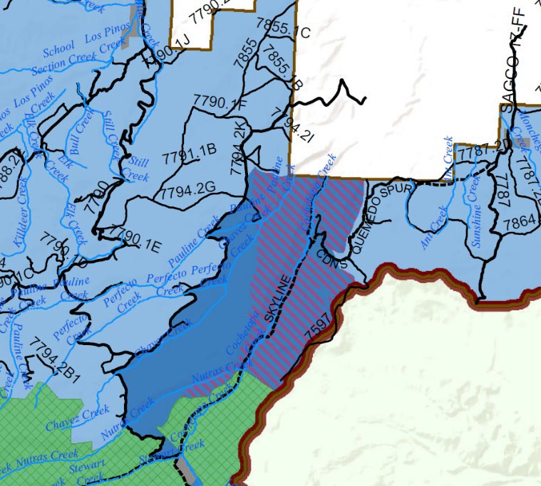
This area provides a spectacular example of why the questions we are asking matter for all areas proposed to be managed under this route density standard. As the CDNST does not directly traverse any analysis grid that might be overlayed in the wildlife area, every grid box will be out of compliance. Many of the grid boxes will be far above the 1 mile per square mile density limit if the trail is going through switchbacks or other climbing type routes that actually make the trail sustainable and maintainable on the ground.
While we are aware this area is remote and there probably is no desire to close the CDNST due to its visibility, this area provides a critical example of the fact the route density threshold is FAR too low and why the management analysis process must be clearly and specifically addressed in the RMP. There are a huge number of trails that could be in this situation.
Resolution of Issue 11.
The Organizations vigorously assert that the GMUG should maintain habitat effectiveness analysis as a planning tool simply to allow easier strategic alignment of forest level resources and national initiatives over the life of the RMP that are being developed with many agencies. This type of analysis has been highly successful and well ahead of its time when the concept was adopted by the GMUG in 1983. If route density standards are maintained, the analysis process must be clearly and directly identified to ensure processes are consistent across the forest and time as there are significant variations in the processes that can be applied.
12(a). Lessons from the 2020 Wildfires in the region.
Wildfire impacts continue to be a huge long-term concern for the recreational community, as any trail that is impacted by wildfire can be closed for decades and possibly permanently. Access to the forest through an extensive maintained system of roads and trails is critical to fire management and firefighting. From our perspective bringing in a hot shot crew from outside the region and then having a crew like this open trails and routes for basic access is a tragically inefficient use of that crews’ skills and the exceptionally limited funding that is available. While the fires garner large amounts of press coverage, the real impacts and work start after the fire is extinguished and bring concerns over a whole new range of issues.
Recreational impacts from wildfire extend well beyond the trails community to all people in the vicinity of these burn scars as exemplified by the 3 Colorado residents that were recently killed in flash flooding in the Poudre Canyon that resulted from the Cameron Peak Fire. We hope everyone can agree these deaths are unacceptable and all efforts should be made to avoid these types of situations moving forward. 2020 proved to be an exceptionally challenging year for wildfires in the Colorado region, and unfortunately the Organizations believe this is a harbinger of fire seasons that will be experienced over the life of the RMP. Often these fires have been summarized as aggressive and devastating due to fuel loads and often the public has thought there was nothing that could be done to mitigate or reduce the impacts of fires of this size and intensity. Review of these fires that have recently occurred indicate that the public perceptions on these large fires may be unnecessarily grim and management can be effective.
The scale of the challenges being faced are exemplified by the East Troublesome Fire on the Sulphur Ranger District, the Mullen Fire on the Laramie Ranger District and Cameron Peak Fire on the Canyon Lakes Ranger District or the Grizzly Creek Fire on the White River. Glenwood Springs was forced to rely on portable filtering equipment after all their existing resources were compromised by the Grizzly Creek Fire; the Mullen and Cameron Peak fires impacted the Cities of Laramie and Cheyenne, Wyoming; Fort Collins, Loveland and Greeley, Colorado in a similar manner after most of the watersheds around municipal reservoirs were heavily impacted by these fires. The Grizzly Creek Fire has reduced I70 through Glenwood Canyon to almost a limited use highway due to the ongoing mud and debris slides from the burn scar. These are simply issues and challenges that no one would have predicted in 2019, and provide a good reason for expanded flexibility in the Proposal in general. No one can predict the future.
While there were significant impacts to all forms of infrastructure, ranging from water resources to interstate highways to local economies, these fires have also provided a significant learning opportunity for managers. We recently participated in round table discussions as part of the CPW Partners in the Outdoors event with numerous Forest Supervisors on the lessons from these fires in terms of behavior of the fire and how to effectively manage these highly intense fires moving forward. Here is a link to that discussion:
PiTO Session NFF USFS Managing Wildlife_Recording.mp4 – Google Drive
This discussion started with a highly detailed day by day analysis of the behavior of several fires in the 2020 season. While everyone is aware of the fact that often issues such as this are often highly related to local factors such as topography, weather and fuel loads, there were several characteristics that consistently were present in these fires, such as the fires naturally igniting in areas were high levels of management restrictions were present and slowly developing in these heavily restricted areas. These fires then explosively grew into areas where large amounts of development or other values were present and created significant impacts to a wide range of uses. At this point, firefighters were not able to control this expansion, which immediately lengthened impacts to almost every resource present in these areas.
In 2020, this trend of fire behavior was exemplified by the Mullen Fire igniting in the Savage Run area; the Cameron Peak fire igniting in the Rawah area and then impacting the Comanche Peak area and then Troublesome Fire burning in and around the Vasquez Peak area and heavily impacting Rocky Mountain National Park. Unfortunately, this characteristic has become common in Colorado as exemplified by the 2013 West Fork Complex Fire ignition in the Weminuche area and the 2018 416/Burro Fire involving several designated remote areas. With several fires following this pattern this year, exemplified by the fires simmering in the Mt. Zirkel and Mt. Sarvis areas outside Steamboat, it appears to be a new normal for fires in Colorado. We have no reason to expect this fire behavior to change over the life of the GMUG RMP.
While the presentation from the CPW “Partners in the Outdoors” event is somewhat lengthy and at times troubling to those that may have been impacted by fire due the analysis of fire behavior, it provided a far more optimistic view of the ability to mitigate impacts and manage even large- scale events such as with tools such as timber harvests and controlled burns at a scale we have never imagined before. While we are aware there are many factors that might be outside a manager’s ability to alter, such as difficult topography in fire impacted areas, prescribed fire and timber harvests are tools that can only be used when there are high levels of management flexibility in the areas to be addressed.
Since the original presentation on forest health was provided at the CPW Partners in the Outdoors event in 2021, significant new research has been provided around the 2020 Fire Season from other highly credible sources such as Colorado State Forest Service, USFS and CSU as well. These researchers are finding that fires are more aggressive, high temperature and longer in duration than ever before. Fires in the beetle kill are simply far more intense than anyone anticipated. We have included three new presentations that have been made to the State Forest Health advisory committee debriefing on the impacts from the 2020 fire season as Exhibit “K”. Again, each of these reports details huge impacts, costs and challenges from the fires new heightened intensity and scale and have resulted from the continued efforts of the motorized community to truly collaborate to address issues on the landscape, as exemplified by the expanded private crew model and expanded use of Conservation Corp being developed in the OHV program moving forward. Even with these new tools, significant flexibility must be provided to address these challenges.
The Organizations would like to discuss the research presentation from Chambers and Rhoades that was provided to the State Forest Health Advisory committee in August 2021. This presentation provided detailed discussions around the consolidated impacts of the Pine beetle, drought and then wildfire and these conclusions were alarming. The conclusions resulted from the fact that drought and pine beetle impacts horribly reduced the numbers of pine cones available to start with before fire. Then the fires were unprecedentedly hot in temperature, long in duration and destroyed the few remaining pine cones in what has become consistently called a blast furnace. These researchers concluded that under these conditions it could take hundreds of years to return these burn scars to any level of normal in terms of habitat effectiveness or recreational opportunities. Given the scope of these challenges, we cannot envision a situationwhere route density would be the primary tool used to address the impacts of challenges such as this. From our perspective, the Proposal is poorly positioned to address management needs such as this and this simply must be corrected. While the motorized community gets blamed for a huge number of problems on public lands, we could never impact the landscape at a level similar to this.
Unforeseen impacts of the large-scale high intensity types of fires continue to be identified, and the lack of ability to foresee possible issues creates a need for more flexibility in management. In February 2021 presentations to the public, the Rio Grande NF in partnership with Colorado Parks and Wildlife provided detailed analysis of post fire impacts from the West Fork Complex Fire to federally protected Lynx on the forest.98 This cutting-edge research showed that while many species returned to low intensity burn scars rather quickly, Canadian Lynx showed a strong aversion to using these areas for a long time. While we are unsure what this means long term, management flexibility to address these types of unforeseen challenges is probably wise.
Unfortunately, the need for management flexibility to address fires is not a new discussion but rather one that has been around for an extended period of time. This is exemplified by the 2011 Rocky Mountain Research Report prepared at the request of Senator Mark Udall entitled “A Review of the Forest Service Response: The Bark Beetle Outbreak in Northern Colorado and Southern Wyoming.” 99 In this report, the Research Station clearly identified the challenges to forest health that result from management restrictions and actually predicted the expanded impacts of wildfire if management was not undertaken. Despite this highly credible analysis of fires and beetles, many still oppose any management on this issue seeking to protect resources by restricting public access to them and managers’ ability to manage them.
Why this warning would not remain valid as a management concern is unclear to us but continues to occur as the Organizations were recently asked to support proposed legislation that would
98 See, Canada lynx navigate spruce beetle-impacted forests | Rocky Mountain Research Station (usda.gov)
99 A complete copy of the 2011 Forest Health report prepared at the request of Senator Udall is available here: HMTG-116-II10-20190710-SD006.pdf (house.gov)
only provide funding for treatments and management on areas that were not Wilderness or Roadless in nature.100 Effectively, this Legislative Proposal precluded treatment on more than 50% of USFS lands in the region and as a result was not supported by us. We instead chose to support proposals that reduced management barriers for treatments and added funding. 101 This is simply another example to the Organizations of the ongoing need to speak up for active management of forests and continue to support management flexibility in planning and we are doing so in this letter. Forest health is a major concern for any forest plan being developed and management flexibility is a major component of addressing this challenge. The Organizations submit these lessons must be quickly applied in any RMP being developed and not be allowed to be simply overlooked as has happened to so many other documents. There are learning experiences that have come out of 2020 and we should be learning from these events.
12(b) The timber industry plays a critical role in healthy forests.
The Organizations are obviously concerned regarding the significant impacts of wildfire on the landscape and that recreational access to areas impacted by wildfire can be lost for decades and take millions of dollars of funding to restore. We believe that a responsible managed timber industry provides an effective tool for the development of sustainable healthy landscapes on the GMUG. It should not be a surprise that our interests align and we are communicating with this group given the large number of committees and groups that each interest serves on. The Organizations support the following input that would lead to the same structural benefits we are seeking. These concerns are:
- While recreation is the GMUG’s #1 economic contributor, that will likely not be the case moving forward if we don’t manage the landscape to prevent catastrophic wildfire and further insect and disease outbreaks;
- The GMUG serves as critical headwaters – but many of the watersheds are not healthy and need Healthy watersheds are a significant part of a healthy landscape and effective habitat and this relationship cannot be overlooked;
- A lot of the economic impact on the GMUG comes from hunting. We must manage habitat to keep our wildlife populations healthy and to provide for continued recreational opportunities;
- The GMUG has one of the largest rangeland resource bases of any national forest in the US, providing economic benefits to our rural communities and this value cannot be overlooked or undervalued; and
- The GMUG is one of the largest commercial timber-producing forests in Region 2 which is supplying wood to the largest remaining sawmill in The Organizations continue to be amazed at the limited amount of timber production infrastructure that remains. If we have learned nothing from 2020/21 it is that local production of resources such as this are highly valuable.
The Organizations are aware there are concerns with the draft plan from the timber perspective:
- Many of the specific categories within the plan have desired conditions that will be difficult to monitor or show progress long-term. We are concerned that without some deliverables, the plan will fall into many of the same issues we have identified, such as maintaining a healthy and vibrant wildlife population in the
- These same categories lack specific objectives. This is especially concerning for The Organizations vigorously request that these objectives be provided as we do not see goals being mutually exclusive from management flexibility;
- Desired conditions for forest structural stages have too big of range (see pages 13-14 of the draft plan). We are especially concerned with the high amount in the later structural stage – this could become an argument not to manage and will reduce resilience;
- The draft plan increases the buffer zone for riparian areas to 100 feet (even on intermittent streams). This is putting our riparian areas at risk. Even riparian areas need management;
- Timber and other Forest Products do not have any specific This is not acceptable as these objectives will ensure that habitats remain effective;
- The Management Approach under timber products (best management practices to maximize carbon storage) is concerning and needs additional language that recognizes that germanely locking up carbon in wood products is a best management
With respect to the proposed alternatives, the timber industry also sees Alternative C as the closest to viable but they are also requesting improvements to Alternative C including:
- The sustained yield is 127,000 ccf per year, yet they are only proposing 55,000 ccf per year (and this includes 5,000 ccf of fuelwood)
- The mill in Montrose needs a harvest level of 70,000 ccf per year to maintain A consistent harvest level should be an objective under both the Socioeconomic section and the Timber and forest product section.
Our partners in the timber industry share our concerns about the wildlife habitat designations and overlapping management standards. While designated acres for timber harvest is a positive, this designation does not resolve the overlapping designations issue as other standards and guidelines will prevent harvest on every acre (such as the lynx amendment). Suited acres provide flexibility to do management in more places, but budgets and operating economics will limit operations. We are glad that the timber industry opposes Alternative D, due to the draconian impacts that the alternative would have on timber management. This is exemplified by the lynx guidance in Alternative D which further restricts management. It will be functionally impossible to meet objective FW-OBJ-WTR-04 under Alternative D with overlapping standards such as this. The Organizations vigorously support the input above as we are aware that a vibrant timber industry is a significant resource for the development of sustainable recreational opportunities on the GMUG at the landscape level.
12(c). Lessons from 2020 recreational visitation spikes.
2020 also provided managers unique opportunities to gain insight into management challenges that could result over the life of an RMP regarding recreational access. This opportunity results from the fact that most public lands saw an increase in visitation of about 30% on average and some areas saw increases of 200-400% of average visitation. The overwhelming portion of this usage was focused on areas of the forest with lower levels of management restriction in general, which is significant as almost 50% of the GMUG is restricted either by Congressional designation or via a similar agency restriction such as a Colorado Roadless or Colorado Upper Tier Roadless type designation. Again, these experiences highlighted the need for management flexibility in addressing concerns around existing facilities and also the need to expand recreational access on the forest to account for this level of increased visitation. We believe the amount of increase in visitation is significant as clearly over the life of the RMP, recreational visitation across the GMUG could easily exceed the 30% average that was experienced in 2020. Much of the 50% of the GMUG that is currently restricted for usage is not able to provide flexibility to adapt to these new demands and visitors, making us question why there would be any desire to expand restrictions. The Organizations believe this type of flexibility is far more probable when herd animal populations are 35% above objective rather than far below.
An example of the clear need to expand facilities across the state was provided by the rapid closure of the State in response to the COVID outbreak. In March of 2020, Governor Polis closed ski areas due to the COVID outbreak when these resorts were near capacity. This immediately pushed visitation levels to many dispersed areas throughout the region far beyond their carrying capacity. The following pictures represent the conditions at parking areas on Berthoud Pass in Grand County.
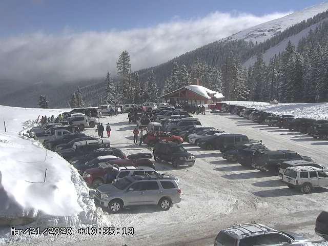
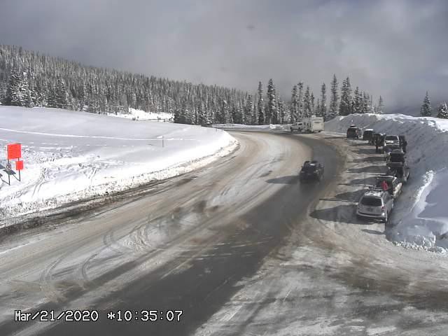
While these issues are not on the GMUG, we submit that they were symptomatic of conditions throughout the region at the time and an example of what was seen in the less restricted 50% of the GMUG lands. This is also a good example of what existing facilities will look like with significantly increased visitation, and possibly may look like towards the end of the GMUG new RMP life. We don’t believe this picture is acceptable to anyone. There is really only one answer to this type of challenge. Opportunities need to be expanded at existing sites and new sites need to be created and this type of management direction can only occur when there is flexibility in planning. Without this type of management flexibility, these types of experiences will become commonplace towards the end of the new RMP life. This is not acceptable to us.
The challenges that have been faced in 2020 from the increased visitation were not limited to roadside facilities along major interstates but rather were experienced throughout the range of the management spectrum. Consistently users sought out their own experiences when existing facilities were either overwhelmed or totally unavailable for use and we don’t see that situation changing regardless of the timeframe being reviewed. This desire to find an experience brought increased pressures to areas facing significant challenges due to unavoidable conditions such as landslides, blow downs or simple lack of funding.
The impacts of these changes were exacerbated by high levels of restrictions on how these challenges may be managed and are commonly experienced in the 50 % of the GMUG subject to heightened management restrictions. The inability to respond to these types of challenges in a timely manner is exemplified by maintenance efforts around the Elk Creek portion of the Continental Divide Trail in Columbine Ranger District in the Weminuche Wilderness. This portion of the trail is only 1/3 of a mile in length. Below is a picture of one of three piles of debris on the Trail after literally weeks of hand work by the Conservation Corp. to open the trail.

Obviously, this is an extraordinary amount of effort to open the trail even this far but there is really no argument that providing these kinds of basic services is complicated by the large number of restrictions on this area. Simply deploying resources to the area is difficult as mechanical transportation is not allowed. The scale of these efforts is made even more daunting by the fact there are multiple other larger piles that must be removed as well. The photos below represent those piles.
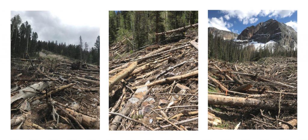
Operating under the current restrictions with existing resources, this challenge could literally take years to repair even though it is only 1/3 of a mile in length. The USFS has sought to address these types of challenges more effectively and efficiently as evidenced by proposals on the Rio Grande NF to reopen trails and access in highly restricted areas by utilizing authority to use mechanical equipment in these areas provided under the Colorado Wilderness Act.102 This proposal was immediately legally challenged and withdrawn.
The USFS has sought to work more efficiently and has proposed the large-scale use of explosives to blow these barriers up and reopen the trail, which the Organizations simply must commend as a super creative resolution to the challenge. We are also aware of the use of explosives previously in other portions of the trail and around water resources in heavily managed areas. While this resolution is commendable, it is certainly not efficient and this lack of efficiency has been recognized by the USFS previously as it is a challenge not only to fixing the condition on the trail or reservoir but simply safely deploying resources to these areas can be difficult. 103 The Organizations also must believe that while explosives on a very limited site-specific basis may be socially sustainable, the Organizations also believe that there would be significant public opposition and concern if the USFS frequently started using explosives as a management tool on the landscape. The Organizations submit there is a limited scope of users seeking the recreational experience provided in these more restricted areas and the recreational experience is often degraded as a result of these management restrictions. Maintenance of opportunities in the more restricted 50% of the GMUG rapidly becomes expensive and as a result degrades the quality of the recreational experience provided to the users.
Compare the challenges and litigation the USFS is facing trying to maintain access and healthy ecosystems in heavily restricted areas to the successful management efforts that have occurred in areas where there are higher levels of management flexibility allowed. An example of how effective management can be when it is not burdened by high levels of restrictions is provided by restoration efforts in areas impacted by the East Troublesome Fire on the Sulphur Ranger District, where partial access was rapidly reopened and the need for management flexibility is immediately clear. Literally hundreds of miles of roads and trails in areas with limited management restrictions, sometimes buried in feet of snow, were rapidly assessed and cleared. After this assessment and stabilization effort safe public access for recreational activity was rapidly restored.104 While the Organizations are aware that every site and project provides unique challenges, the Organizations submit this type of massive project would still be ongoing in Grand Lake if management restrictions were in place at levels found in some areas. Simply covering the hundreds of miles of trails on foot and removing hazards by hand would have taken possibly years.
The Organizations submit that the social benefits of lower levels of management restrictions cannot be overlooked either. The Organizations would also note that the Grand Lake efforts were successful in uniting a wide range of people and interests in the project, while similar efforts in more restrictive areas drew litigation. Building communities around successful projects only creates more success in the future as land managers are facing new and unique challenges. Obviously, this is a win for everyone compared to the immediate litigation that resulted from efforts to effectively manage areas subject to higher levels of restrictions. Again, we must ask why increases for restrictions would be sought in the face of the social opposition that is so common in the public when they can’t fix problems.
13. No additional Wilderness recommendations.
The designation, release and protection from wilderness designations is another area where the motorized community has actually collaborated to permanently resolve issues on the GMUG. This has resulted in several pieces of legislation that has designated and released areas from further analysis for Wilderness designation. The Organizations were deeply disappointed that while pending legislation such as CORE are recognized in the Proposal, at no point have previous legislation decisions that have passed into law on the GMUG been addressed that specifically identify areas released for “non-Wilderness multiple use”. We simply cannot envision a situation where actual legislation that was passed into law has been properly ignored while pending legislative proposals, some of which have been around for more than 30 years, would be addressed in the Proposal. The Organizations are opposed to any recommended Wilderness on the GMUG and our opposition to such designations has been outlined in great detail in the comments we have submitted previously.
14. Economics of recreation must be accurately reflected.
The Organizations have previously submitted extensive information on the economic benefits that accrue from outdoor recreation, and more specifically motorized outdoor recreation, as part of our August 31, 2017 submission on the Proposal. We have heard significant discussion from some interests on the value of recreational activity as an economic driver to local communities, while continuing to push for exclusive usages for small numbers of users. This simply makes no sense.
While we have no interest in repeating our previous submissions on the issue of economics, we would like to recognize the newly released outdoor recreational activity analysis from the Bureau of Economic Analysis of Dept of Commerce.105
The 2020 BEA report also identified the following trends for spending in the top 6 categories as follows106:
While the powerboat industry is probably not relevant to the GMUG planning effort, each of the other top six categories are highly relevant and often are activities that are consolidated for trips. Families may fish one day, ride dirt bikes or side by sides, recreationally shoot the next while basing this out of their RV. It should be noted that many of the interests that are seeking their own special use area designations on the GMUG are not even in the top of the list for spending levels either at the state or national level. The Organizations submit this should weigh heavily against any claim of benefits from these continued expansions of these designations on the GMUG.
The DOI Outdoor Recreation Roundtable provided the following comments on the new BEA report from the Department of Commerce specifically identified that:
“Industry segments like boating and fishing, biking, camping and RVing, hunting and shooting sports, and powersports experienced record sales and unprecedented growth”
The Outdoor Recreation Roundtable continues to summarize the report as follows:
“Outdoor participation soared, especially close-to-home recreation, highlighting the importance of better access to the outdoors for all communities.”107
The Organizations must again welcome further confirmation that the economic contribution of motorized recreation and related motorized access tools such as RVs is immense. This economic contribution far outpaces any other type of economic driver and should not be overlooked in the planning processes. Economic activities only increase when large groups spend money and the more the larger the group spends the better the economic driver becomes.
15(a). Site specific concerns are rarely generated by motorized users.
The Organizations are making these comments in addition to any club-based input that might be received. The Organizations would like to start with a landscape concern on this issue, mainly the fact that the motorized community so rarely gets to build new trails or expand access that it is a question that rarely if ever gets asked. We consistently have been faced with the opposite of expanding access in planning as we have always been in the situation of seeking to save 60% of trails in an area and calling it a win. Even when we have tried to expand access on small scales, the fight has been significant and barriers are simply invented and efforts are usually exceptionally long that often by the time trails might be built there are the next generations of club members involved.
15(b). Existing expansion areas are not addressed in the Proposal.
It is with this position we would like to ask at the landscape the basic question of where are the least controversial areas on the GMUG for us to build trails? This would apply to both summer and winter motorized usages. We would love to build trails in these areas as we have the funding to build and maintain these resources and we believe these expansion areas will be badly needed over the life of the RMP.
This general request is why we have addressed many of the landscape standards that are proposed, such as route density, wildlife habitat and roadless areas with such specificity. These factors must be meaningfully addressed and balanced in order for us to identify even small areas where motorized access might be expanded. This type of a concern is also why we are so concerned about the reliance on ROS as a management standard rather than analysis based on management designation.
As an example: While a thousand acres of GMUG land may only have one route crossing it at this time, the management would allow motorized usage of this area. The entire one thousand acres might be an expansion area but any discussion of expansion is lost when the majority of those thousand acres is identified as non-motorized simply because of its lack of proximity to the existing route based on ROS calculations. This is simply inaccurate. We see this thousand-acre plot as an area where new trail loops could be built, possibly connectors to other trails and other discussions could occur in subsequent site specific NEPA. Right now, we can’t have those discussions as these types of opportunities are not provided in the Proposal.
15(c) Site Specific comments and concerns.
We have included some route specific comments from the Gunnison NF travel plan that identify routes that were closed we would like to see reopened or areas we would like to see reconnected. We are also in possession of extensive notes from the Grand Mesa travel plan that provide extensive discussions around our loss of access in that planning effort.
We are also aware that the COHVCO motorized action plan has limited site specific areas we would like to see expansion of. We are not including these here simply to avoid repetition of input.
Additionally, we are aware that the Norwood Ranger District is currently looking at expanding singletrack trails in the Beaver Park and Busted Arm area. This proposal is vigorously supported by the Organizations and we would like to see this identified as a priority in the RMP.
GMUG ROS Changes and Corrections to Alternative C
Gunnison Ranger District
- Pitkin
- The Recreation Opportunity Spectrum (ROS) encompassing the following Route(s) is requested to be changed from Semi Primitive Non-Motorized (SPNM) to Semi Primitive Motorized (SPM)
- Routes # 9478 (Fossil Ridge), 9549 (Cameron Gulch), 9427 (Gold Creek) and 9426 (Fairview).
- The end of both Routes # 2B (Blistered Horn) & 7765.2C (West Willow)
- The Recreation Opportunity Spectrum (ROS) encompassing the following Route(s) is requested to be changed from Semi Primitive Non-Motorized (SPNM) to Semi Primitive Motorized (SPM)
- Sargents
- The ROS area surrounded by the following Route(s) is requested to be changed SPNM to SPM ROS
- Route #’s 9487 (Razor Creek) & 9485 (Lefthand).
- The ROS encompassing the following Route(s) is requested to be changed from SPNM to SPM
- Route # 9538 (Dawson Creek)
- Route #’s 7806 (Beaver Creek) & 7807 (Rock Creek)
- The following Route(s) have segments or spurs with SPNM that are requested to be changed to
- Routes # 7854 and 1 spur 2L (Homestead & Homestead Spurs)
- Routes #7801, 7801.1A & A1 (Tomichi Dome & Tomichi Dome Spurs)
- The ROS Roaded Natural (RN) surrounding the following Route(s) is requested to be expanded to allow for unforeseen future circumstances (fires, floods, landslides, etc.) that would require alterations to the existing alignment on the following
- Route #7794 (Cochetopa Creek)
- The following Route(s) have mapping Many of which are motorized segments of the Continental Divide National Scenic Trail and/or Colorado Trail.
- Route #9531 (Monarch Ridge/Monarch Crest) is a motorized trail listed as a non-motorized trail on both sides of HWY 50 surrounding the Monarch Pass Summit in all Alternatives and needs to be
- Route #9484 (Agate Creek) is motorized West of the intersection of #9531 (Monarch Ridge/Crest). A small section is shown as non-motorized in all Alternatives and needs to be
- Route #7243.3H/9486 (Windy Peak/Summit Trail) has an Administration “motorized restricted use” trail designation and should be converted to a motorized
- Route #9499 (Pine Creek) is a motorized trail from CO HWY 114 to NN14 (Cochetopa Pass). Map designations of non-motorized and/or Administration “motorized restricted use” should be converted to motorized
- Route # 9625 (Milk Creek) needs access restored around private land
- The ROS area surrounded by the following Route(s) is requested to be changed SPNM to SPM ROS
- Lake City
- The ROS Roaded Natural (RN) surrounding the following Route(s) is requested to be expanded to allow for unforeseen future circumstances (fires, floods, landslides, etc.) that would require alterations to the existing alignment on the following
- Route # 7788 (Cebolla Creek)
- The ROS encompassing the following Route(s) is requested to be changed from SPNM to SPM
- Route #7568 (Wager Gulch)
- Route #9248 (Wager Gulch Memorial Trail)
- Routes # 870(N. Henson Creek) & 2A (Matterhorn Creek)
- The ROS Roaded Natural (RN) surrounding the following Route(s) is requested to be expanded to allow for unforeseen future circumstances (fires, floods, landslides, etc.) that would require alterations to the existing alignment on the following
- Crested Butte/Taylor Park
- The ROS encompassing the following Route(s) is requested to be changed from SPNM to SPM
- Route # 9561 (Eyre Basin)
- Route #9413 (Matchless) to Taylor Reservoir
- Routes #9424 & 1A (Dr. Park) from Route #7554 to Route #742.1A
- Route # 7585 & 9585(Gunsight Pass)
- Route # 1D (Green Lake)
- Route # 9436 (Carbon)
- Route # 7563 (Carbon – Red Mountain) & Spurs # 1A & 7563.2A
- The following Route(s) have segments with ROS SPNM that are requested to be changed to SPM
- Route # 9423 (Rosebud)
- Route # 9554 (Teocali Mountain)
- Route # 1T (South Lotus)
- Route # 1E (Flat Top Bench)
- Route # 9378 (Brush Creek Jeep/Pearl Pass)
- Routes # 7761 (Taylor Pass) & 1A (Taylor Pass Divide)
- The ROS SPM surrounding the following Route(s) is requested to be expanded to allow for unforeseen future circumstances (fires, floods, landslides, ) that would require alterations to the existing alignment on the following
- Route # 9414 (Timberline) North of Route # 7209 (Cottonwood Pass)
- The ROS Roaded Natural (RN) surrounding the following Route(s) is requested to be expanded to allow for unforeseen future circumstances (fires, floods, landslides, etc.) that would require alterations to the existing alignment on the following
- Route # 7584 (Tellurium) & 1C (Pine Creek)
- Route # 9631 (Lotus Creek)
- Route #7752 (Poverty Gulch)
- The following Route(s) have mapping errors
- FT #’s 9561 (Eyre Basin), 9413 (Matchless) to Taylor Reservoir are listed in all Alternatives as open motorized routes, however these FT were closed in previous TMP and are not recognized on the Gunnison Ranger Districts current inventory as trails for motorized or non motorized
- The ROS encompassing the following Route(s) is requested to be changed from SPNM to SPM
- Gunnison/Blue Mesa
- The ROS encompassing the following Route(s) is requested to be changed from SPNM to SPM
- Routes # 7859 & 7637 (Sun Creek), # 7574 (Black Gulch)
- Routes # A2 & 7609.A3 (Bear Springs Spurs)
- Routes # 7721 (Soap Creek), #7721.3F (Big Soap)
- The ROS encompassing the following Route(s) is requested to be changed from SPNM to SPM
Norwood/Ouray Ranger Districts
- Ridgway/Ouray
- The following Routes have segments with ROS SPNM that are requested to be changed to SPM
- Route # 1 (Middle Fork Cimarron)
- Route # 860 (West Cimarron)
- Route # 857 (Cow Creek)
- Route # 870 (N. Fork Henson) & # 8702.A (Matterhorn Creek)
- The ROS encompassing the following Route(s) is requested to be changed from SPNM to SPM
- Routes #878 (Engineer Pass), 876 (Poughkeepsie Gulch) & 873 (Silver Link Mine)
- 886 (Corkscrew Gulch), 887(Gray Gulch) & 884 (Brown Mountain)
- Seasonal Closures on the following Route(s) limiting motorized recreation from July 1st to September 1st (60 days) are too limited and are requested to be
- Route # 6221 (Nate Creek)
- The following Route(s) in the Ridgway/Ouray area have mapping errors
- #6221 (Nate Creek) is a motorized trail listed as a non-motorized trail in all Alternatives and needs to be corrected.
- The following Routes have segments with ROS SPNM that are requested to be changed to SPM
- Telluride
- The ROS encompassing the following route(s) is requested to be changed from SPNM to SPM
- Route # 630 (Ophir Pass)
- Route # 648 (Black Bear Pass)
- Route # 869 (Imogene Pass)
- Route # 5421 (Wilson Mesa)
- Route # 1B (Yankee Boy Basin)
- Route # 1C (Governor Basin)
- Route # 1C1 (Sydney Basin)
- Route # 850 (West Dallas)
- Routes # 1A & 6233 (Richmond Basin)
- The ROS encompassing the following route(s) is requested to be changed from SPNM to SPM
- Uncompahgre South
- Seasonal Closures on the following Route(s) limiting motorized recreation from July 1st to September 1st (60 days) are too limited and are requested to be
- Routes # 5118 (Red Canyon), 5541 (Powerline), 6131(Hornet Creek), 6126 (Paradox), 6149 (Buck Creek), 5516 (Clear Creek) & 5421(Wilson Mesa)
- Note: The organizations support Motorized Multi Use Trail Development in the Norwood Ranger District. Specifically Busted Arm Draw and Beaver Park areas as proposed by the Norwood Parks and Recreation District
- Seasonal Closures on the following Route(s) limiting motorized recreation from July 1st to September 1st (60 days) are too limited and are requested to be
Grand Valley Ranger District
- Uncompahgre North
- The ROS encompassing the following Route(s) is requested to be changed from SPNM to SPM ROS
- Route # 600 (47 Road)
- Routes #2632 (Franks Bench), #2634 (Bunch Ground) & 2620 (Blue Creek)
- Seasonal Closures on the following Route(s) limiting motorized recreation from July 1st to September 1st (60 days) are too limited and are requested to be
- Routes # 2621(Long Canyon),2627(Beaver Dam)
- The ROS encompassing the following Route(s) is requested to be changed from SPNM to SPM ROS
- Grand Mesa
- ROS SPM surrounding the following Route(s) is requested to be expanded to allow for unforeseen future circumstances (fires, floods, landslides, etc.) that would require alterations to the existing alignment on the following
- Route # 2719 (East Green Mountain)
- ROS SPM surrounding the following Route(s) is requested to be expanded to allow for unforeseen future circumstances (fires, floods, landslides, etc.) that would require alterations to the existing alignment on the following
Paonia Ranger District
- Grand Mesa East
- The ROS encompassing the following Route(s) is requested to be changed from SPNM to SPM ROS for future trail development
- Routes # 8810 (Clearfork),8812 (Jones Creek), 8814 (Gooseberry), 8815 (Drift Creek)
- The ROS encompassing the following Route(s) is requested to be changed from SPNM to SPM ROS for future trail development
- Paonia
- The ROS encompassing the following Route(s) is requested to be changed from SPNM to SPM ROS for future trail development
- Route # 8820 (Raggeds)
- Route # 8842 (Beckwith Pass) to 8840 (Cliff Creek)
- Route # 8848 (Three Lakes)
- Route # 8838 (Dyke)
- Route # 720 (Curecanti Creek)
- Route #8872 (Trail Creek)
- Route #8888 (Dyer Creek)
- Route #8884 (Mendicant Ridge)
- Route #8880 (Pyburn)
- Route #8881 (Castle Rock)
- Route #814 (Virginia Creek)
- Route #8864 (Through line Jeep)
- Route #8883 (Coal Creek)
- Route #835 (Little Coal Creek)
- Route # 8890 (Inner Ocean Pass)
- Route # 8894 (Lamborn)
- Route # 8891 (Todd Reservoir)
- Route # 8897 (Lands End)
- Route # 2A (McDonald Mesa Spur A)
- Route #834.2A (City Springs Spur A)
- Route # 834 (City Springs)
- The ROS encompassing the following Route(s) is requested to be changed from SPNM to SPM ROS
- Routes # 913 (Shaefer) & Spurs 1A and 913.1B
- The ROS area surrounded by the following Route(s) is requested to be changed SPNM to SPM ROS
- Routes # 8711 (Raven Mesa) and spurs W & 8711.V1
- Routes # 711 (Dry Fork MN Creek), 3C (The Pines) 711.3B/8721(East Flatiron) 8721 (West Flatiron) 8720.1A (Rav 1 Spur) 8871 (Long Draw Saddle)
- The following Route(s) have segments with ROS SPNM that are requested to be changed to SPM
- Routes # 3A (Sunset), 711.2D (Ditch Cabin), 8723 (Elijah’s Park)
- The ROS encompassing the following Route(s) is requested to be changed from SPNM to SPM ROS for future trail development
15(d) Seasonal closures must protect wildlife not grant preferred access.
One consistent concern we hear raised from our users on the GMUG is the exceptionally brief nature of access to many of the routes that result from early seasonal closures due to hunting seasons. While we support the concept of seasonal closures to protect wildlife, we are concerned that often seasonal closure dates are becoming a basis to address user conflicts. We are opposed to seasonal closure dates that allow exclusive access to areas for other activities such as hunting. This is patently unfair and creates user conflict.
This type of seasonal closure also invites users to violate the seasonal closures, even if they are participating in the protected activity as such a management action operates on the erroneous assumption that hunting is a non-motorized sport. This could not be further from the truth. Many hunters prefer motorized access to their hunting areas for almost every phase of their hunt. These users are often frustrated by closure gates and other management efforts that preclude them from using motorized transport to hunt, and often seek to avoid those management tools. This type of a concern was highlighted in recent law enforcement pilot study reports that were prepared by CPW and the USFS analyzing violations across the state.
16. Conclusion.
Of the Alternatives provided, Alternative C of the Proposal is the best presented but this Alternative needs significant work. A major step forward in Alternative C would be the inclusion of a landscape level management standard that creates a protective corridor around any route where the route is inconsistent with adjacent management or ROS. This is hugely justified as every route on these maps has been through travel management multiple times. We are also concerned that in some geographic areas that Alternative B provides far better access than Alternative C, despite the assertion that Alternative C is the most intensive level of access.
We think Alternative C is the most accurate reflection of current management and are VIGOROUSLY opposed to Alternative D of the Proposal. Candidly, Alternative D is so unrealistic we are going to avoid substantive discussion of many of the standards in this Alternative. Alternative D represents a huge number of areas that we have sought to protect in previous collaborative efforts. Often these previous NEPA collaboratives were undertaken only with significant effort and compromise from the member Organizations, is deeply disappointing to the Organizations and our members as often much of what has been proposed in citizen alternatives and sometimes alternatives in the Proposal are exactly the discussions previously raised, subsequently reviewed in NEPA and then declined to be applied.
We are unsure what Alternative A of the Proposal is attempting to reflect, as this mapping and information directly conflicts with current management designations of many areas. Alternative A is the result of the failure to accurately, consistently and completely reflect many of the site specific NEPA components, analysis and decisions that has occurred over decades on the GMUG within the existing management decision framework.
In a more troubling twist, often the inventory of site-specific analysis done within existing management designations is sought to be applied in a manner that directly conflicts with the clear scope of those efforts. Management designations are management designations and inventories are inventories and these are concepts that cannot be interchanged at will in the planning process. Our concerns around the Draft RMP would include:
- We welcome the brief nature of the RMP but at this point are confused by many of the assertions on management that have been made and subsequently changed in this process such as existing ROS scope;
- We continue to struggle with the challenge regarding accurate integration and representation of existing NEPA and statutory changes that have occurred over the life of the 1983 RMP; While we appreciate efforts to provide public better information on possible impacts often this info was late and as a result, we are asking for existing motorized routes be provided a protective Corridors when these previously analyzed routes cross areas of inconsistent management;
- Inventory levels for motorized areas have reduced by 24% over the life of the 1983 plan based on subsequent NEPA when these site-specific decisions clearly and unequivocally state there was no change to management standards is within the scope of that analysis and these are existing expansion areas for motorized usage and we can’t discuss them as this information is not provided;
- Roadless area inventory of limited area characteristics are now sought to be applied as a management standard for all uses of these areas. This confuses the public in planning and will create confusion over the life of the RMP;
- Populations of wildlife on the GMUG have been steady and increasing over the life of the 1983 RMP, based on published peer reviewed information from CPW and as a result we must question why there would be significant restrictions imposed to protect wildlife beyond those already in place;
- The large-scale implementation of a draconian mile for mile route density standard in wildlife management areas conflicts with USFS and CPW published and peer reviewed guidance on this issue. We are unable to locate any species whose habitat is actually entirely under this threshold causing significant concern regarding assertion from the Forest of minimal impacts from this standard;
- Winter ROS information is woefully inadequate and as a result we are asking that any winter ROS decisions be postponed until adequate information is available and can be incorporated in subsequent travel plans for the issues; and
- There simply needs to be more access to the forest for all types of recreational usages, which was confirmed by the complete overrunning of existing facilities in 2020;
The Organizations would welcome a discussion of these opportunities and any other challenges that might be facing the GMUG moving forward at your convenience. Please feel free to contact Scott Jones, Esq. His phone is (518)281-5810 and his email is scott.jones46@yahoo.com or Chad Hixon whose phone is (719) 221-8329 and email is chad@coloradotpa.org.
Respectfully Submitted,
Scott Jones, Esq.
CSA Executive Director
TPA/COHVCO Authorized Representative
Chad Hixon
Executive Director
Trail Preservation Alliance
Marcus Trusty
President – CORE
Enclosures
1 See, 40 CFR 1500.1[1]
2 See, 43 CFR 1500.1(b)
3 See, Hughes River Watershed Conservancy v. Glickman; (4th Circ 1996) 81 f3d 437 at pg. 442; 42 ERC 1594, 26 Envtl. L. Rep 21276
4 A complete copy of these comments with attachments upon request. These are not included with these comments simply to avoid repetition of information being submitted.
5 A complete copy of this strategy and more information on the process as a whole is available here: National Strategy for a Sustainable Trail System | US Forest Service (usda.gov)
6 See, PUBLIC LAW 114–245—NOV. 28, 2016
7 See, National Trails strategy at pg. 4.
8 A complete copy of this correspondence is attached as Exhibit “A”
9 See, DEIS pg. 13.
10 See, DEIS pg. 18.
11 See, GMUG EIS 2021 Volume 1 at pg. 347.
12 See, GMUG 2021 Environmental Impact Statement; Volume 1 at pg. 347.
13 See, USDA Forest Service; GMUG Final Supplemental Environmental Impact Statement 1991 at pg. 4.
14 See, USDA Forest Service; GMUG Final Supplemental Environmental Impact Statement 1991 at pg. I9.
15 See, USDA Forest Service; 1983 GMUG Resource Management Plan at pg. II-29.
16 See, GMUG 2021 Environmental Impact Statement; Volume 1 at pg. 347.
17 See, USDA Forest Service; 36 CFR Parts 212, 251, 261, and 295; Travel Management; Designated Routes and Areas for Motor Vehicle Use; Final Rule 68264 Federal Register / Vol. 70, No. 216 / Wednesday, November 9, 2005 / Rules and Regulations
18 See, USDA Forest Service; GMUG Uncompahgre Travel Management Plan Record of Decision; 2002 at pg. 10.
19 The Organizations are in possession of several unopened map packages from the Uncompahgre Travel planning effort and are willing to provide copies on request. We are aware that much of this environmental documentation is not available for reasons that are never explained.
20 See, Gunnison National Forest TMP ROD at pg.38
21 See, USDA Forest Service, GMUG Draft Revised Resource Management Plan, August 2021 at pg. 92.
22 See, USDA Forest Service; National Roadless Rule; Final 2001; Vol. 66, No. 9 Federal Register; Friday, January 12, 2001 at pg. 3244.
23 See, USDA Forest Service; Colorado Roadless Rule; Final Environmental Impact Statement; Appendix C May 2012 at pg. 1.
24 See, USDA Forest Service; Colorado Roadless Rule; Final 2012; Vol. 77 No. 128 Federal Register; Tuesday July 3, 2012 Friday, January 12, 2001 at pg. 39606.
25 See, USDA Forest Service; Colorado Roadless Rule; Final 2012; Vol. 77 No. 128 Federal Register; Tuesday July 3, 2012 Friday, January 12, 2001 at pg. 39583
26 See, USDA Forest Service GMUG Draft Forest Plan; Draft Environmental Impact Statement; August 2021 Volume 2 at pg. 409.
27 See, USDA Forest Service; Colorado Roadless Rule; Final Environmental Impact Statement; May 2012 Appendix B at pg. B-4.
28 See, Olsen et al, Modeling large-scale winter recreation terrain selection with implications for recreation management and wildlife; Applied Geography 86 (2017) 66e91
29 See, CPW Elk management plan for Unit E43 Fossil Ridge; January 2001 at pg. 13.
30 See, CPW Elk management plan for Unit E24 Disappointment Creek; September 2020 at pg. 1.
31 See, CPW Elk management plan for Unit E24 Disappointment Creek; September 2020 at pg. 2.
32 See, Western Association of Fish and Wildlife Associations- Mule Deer Working Group; 2020 Range Wide Status of Black Tailed and Mule deer at pg. . A complete copy of this report is available here. 2020_MuleDeer-and- BTD_Status-Update.pdf (wafwa.org)
33 See, CPW D25 Powderhorn Herd plan; January 2013 at pg. 2.
34 See, CPW D25 Powderhorn Herd plan; January 2013 at pg. 3.
35 D53 unit plan at pg. 21.36 Winter Kill Forecast: Will Harsh Conditions Devastate Colorado Deer and Elk? (outdoorlife.com)35 D53 unit plan at pg. 21.
37 The Western Megadrought Is Killing Mule Deer | Outdoor Life
38 See, COLORADO PARKS & WILDLIFE • 2020 Status Report: Big Game Winter Range Migration Corridors • May 2020 at pg. 11. A copy of this report has been submitted with these comments as Exhibit “C”. Hereinafter referred to as the 2020 CPW Corridor Study
39 See, CPW 2020 Status Report: Big Game Winter Range Migration Corridors • May 2020 at pg. 8.
40 Copies of both the 2017 and 2001 E25 herd management plans are attached to these comments as Exhibit “D”.
41 See, Colorado Parks and Wildlife; 2017 E25 Herd management plan at pg. 9
42 See, Weyerhaeuser Company v. United States Fish and Wildlife Service, 586 U.S. ; 139 S. Ct. 361; 202 L. Ed. 2d 269. (2018)
43 See, USDA Forest Service; GMUG NF DEIS August 2021 at pg. 30
44 Quantifying restoration effectiveness using multi-scale habitat models: Implications for sage-grouse in the Great Basin (fs.fed.us)
45 See, CPW ELK Management plan for GMU E05; June 7 2018 @ pg. 13.
46 See, CPW Deer Management Plan for DAU 24 Groundhog; March 2014 at pg.2
47 See, USDA Forest Service; Rocky Mountain Research Station; Interactive Habitat Mapping tool available here: ArcHSI (Arc Habitat Suitability Index) | Rocky Mountain Research Station (usda.gov)
48 See, Olsen et al; Modeling Large scale winter recreational terrain selection with implications for recreation management and wildlife; Journal of applied Geography; June 2017 at pg. 66.
49 A copy of this manual is available here: 122968 (fws.gov)
50 See, Gunnison Basin TMP FEIS at pg. 62
51 See, USDA Forest Service, Gunnison National Forest; Gunnison Basin Federal Lands Travel Management; Final Environmental Impact Statement; June 2010 @Pg. 109
52See, USDA Forest Service, Gunnison National Forest; Gunnison Basin Federal Lands Travel Management; Final Environmental Impact Statement; June 2010 @ Pg. 70
53 See, USDA Forest Service, Gunnison National Forest; Gunnison Basin Federal Lands Travel Management; Final Environmental Impact Statement; June 2010 @ Pg. 99
54 See, USDA Forest Service, Gunnison National Forest; Gunnison Basin Federal Lands Travel Management; Final Environmental Impact Statement; June 2010 @ Pg. 98
55 See, USDA Forest Service, Gunnison National Forest; Gunnison Basin Federal Lands Travel Management; Final Environmental Impact Statement; June 2010 @ Pg. 116
56 Total obtained by combining road density and trail density provided in DEIS at pg. 189 & 191
57 Total obtained by combining road density and trail density provided in DEIS at pg. 189 & 191.
58 We have not included a copy of this document as it is several hundred pages in length but can be downloaded here: Sustaining Wildlife with Recreation on Public Lands: A Synthesis of Research Findings, Management Practices, and Research Needs (fs.fed.us)
59 See, USFS Trails and Wildlife Guide at pg. 24.
60 See, CPW Trails and Wildlife Guide at pg. 20.
61 See CPW Trails and Wildlife Guide at pg. 11.
62 See, Colorado Parks and Wildlife; Colorado’s Guide to Planning trails with wildlife in mind; June 2021 at pg. 24.
63 See, Colorado Parks and Wildlife; 2020 Status Report; Big Game Winter Range and Migration Corridors at pg.31
64 See, Miller, A.B.; King, D.; Rowland, M.; Chapman, J.; Tomosy, M.; Liang, C.; Abelson, E.S.; Truex, R. 2020. Sustaining wildlife with recreation on public lands: a synthesis of research findings, management practices, and research needs. Gen. Tech. Rep. PNW-GTR-993. Portland, OR: U.S. Department of Agriculture, Forest Service, Pacific Northwest Research Station. 226 p. A complete copy of this report has not been included with these comments due to its size. This report is available to download here. Sustaining Wildlife With Recreation on Public Lands: A Synthesis of Research Findings, Management Practices, and Research Needs (fs.fed.us)
65 See, Miller et al at pg. 20.
66 See, Miller et al at pg.
67 See, USDA Guide at pg. 41
68 See, USDA Forest Service; Gunnison Basin Travel Management Plan FEIS; April 2010 at pg. 275-278.
69 See, Western Governors Association; Case Study: State, Federal, Local and Private Entities Collaborate to Build Wildlife Crossings along a 12-Mile Stretch of Highway 89 in Southern Utah; April 2014 at pg. 4.
70 See, Dept of Interior; US Fish and Wildlife Service; Threatened Status for the Distinct Population Segment of the North American Wolverine Occurring in the Contiguous United States; Establishment of a Nonessential Experimental Population of the North American Wolverine in Colorado, Wyoming, and New Mexico; August 13, 2014 2014- 18743.pdf (fws.gov)
71 47532 Federal Register / Vol. 79, No. 156 / Wednesday, August 13, 2014 / Proposed Rules
72 See, USFWS 2016 update at pg. 5.
73 See, DOI; US Fish and Wildlife Service; Endangered and threatened wildlife and plants; removing the gray wolf from the list of Endangered and Threatened Wildlife; Federal Register Vol 85 No 213 at pg. 69870.
74 See, Wyoming Fish and Game; Wyoming Gray Wolf Management Plan 2011 at pg. 30.
75 See, Wyoming 2016 update pg. WY-6.
76 See, DOI USFWS; Service Review of the 2018 Wolf Population in Wyoming; May 2, 2019 at pg. 2.
77 See, USDA Forest Service, GMUG National Forest; Draft Revised Forest Management plan; August 2021 at pg. 93.
78 See, Proffitt Et Al; Integrated Carnivore-Ungulate Management: A Case Study in West-Central Montana Wildlife Monographs June 2020.
79 See, Idaho Fish and Game; 2017 Statewide Report – Wolf; 2017 at pg. 8.
80 See, DOI; US Fish and Wildlife Service; Endangered and threatened wildlife and plants; removing the gray wolf from the list of Endangered and Threatened Wildlife; Federal Register Vol 85 No 213 at pg. 69868.
81 See, Idaho Fish and Game; 2002 Wolf Plan at pg. 21 of 32.
82 See, Idaho Fish and Game; 2002 Wolf Plan at pg. 16 of 32.
83 See, RMP FEIS at pg. 178.
84 See, US DOI USFWS; Species Status Assessment report for the Gunnison Sage-Grouse; April 2019 at pg. 41.
85 The Weyerhaeuser decision is attached to these comments and discussed in greater detail in other portions of these comments.
86 See, Final CCA at pg. 25.
87 See, USDA Forest Service; GMUG National Forest Resource Management Plan DEIS; August 2021 at pg. 191.
88 See, Outdoor Alliance Report on GMUG at pg.25 Based on our review of these proposals there is no distinction between Gunnison Citizens and GPLI
89 See, DeJong et al: Trustees oppose recreation plan: The Mountain Mail; July 2, 2021 at pg. 3.
90 Letter to the Editor: Chaffee County Draft Recreation Plan – by Community Contributor – Ark Valley Voice
91 See, Exhibit 5 to scoping comments of the Organizations to GMUG NF dated May 31, 2018.
92 See, RMP Proposal at pg. 43
93 A copy of the US Supreme Court’s Cowpasture decision is attached as Exhibit “J”.
94 See, Joint Chiefs’ Landscape Restoration Partnership | NRCS (usda.gov)
95 More information on this national effort of the USFS is available here: USDA Forest Service – Healthy Forests Initiative (fs.fed.us)
96 A complete version of the volumes of information involved in this NOAA effort is available at the following sites: Understanding Ecosystem-Based Fisheries Management | NOAA Fisheries and Ecosystem based management | Integrated Ecosystem Assessment (noaa.gov)
97 This information is available here: Initiatives to Create and Protect Healthy Watersheds | US EPA
100 A complete copy of this proposal is available here: Bennet Introduces Legislation to Invest in Forest, Watershed Restoration Across the West | Press Releases | U.S. Senator Michael Bennet (senate.gov)
101 A copy of this proposal is available here: untitled (house.gov)
102 See, PL 96-560 §109
103 See, Forest crew uses explosives in wilderness area | Wyoming News | trib.com
104 See, Fire damage won’t stop snowmobiling in Grand Lake | SkyHiNews.com
105 A complete version of the 2020 report is available here: Outdoor Recreation | U.S. Bureau of Economic Analysis (BEA) . The national BEA summary is attached to these comments as Exhibit “L”
106 See, Dept of Commerce; Bureau of Economic Analysis; News Release; Outdoor Recreation Satellite Account; US and States 2020 @ pg. 5
107 A complete copy of this press release is available here: Updated Government Report Highlights Outdoor Recreation’s Positive National Economic Impact and in Every State – Outdoor Recreation Roundtable