Author Archive | Administrator

2012 Update of OHV Recreation on the Colorado Economy

Economic Contribution of Off-Highway Vehicle Recreation in Colorado


pdficon_large.gif Exective Summarypdficon_large.gif Full Report


EXECUTIVE SUMMARY

Submitted to:
Trails Presevation Alliance
PO Box 38093
Colorado Springs, Colorado 80937

Submitted by:
The Louis Berger Group
535 16th Street, Suite 600
Denver, Colorado 80202

August 2013

Introduction
Colorado offers unique opportunities for motorized recreation1 because of its vast terrain appropriate for off-highway motorized use. As such, the sport and industry of motorized recreation has increased in popularity in Colorado for both residents and non-residents. The Louis Berger Group, Inc. (Louis Berger) evaluated the economic contribution of motorized recreation in Colorado for the 2012-13 season2 and summarizes the results in this report.
Much of the analysis presented here is based on a 2001 study completed by Hazen and Sawyer titled Economic Contribution of Off-Highway Vehicle Use in Colorado (the 2001 study).3 The 2001 study includes a household survey that collected valuable information on where and when motorized-recreation enthusiasts utilized their vehicles for recreation, average expenditures associated with recreational trips, and annual expenditures associated with operating and maintaining vehicles. Louis Berger adjusted information on collected in that study for inflation and used it in combination with current data on the number of households that participate in motorized recreation in the state to estimate the total economic contribution of the sport in Colorado.

Households4 that Participate in Motorized Recreation
OHV registrations increased by 131 percent between 2000 and 2012. The bulk of growth occurred between 2000 and 2007 and was fairly constant between 2007 and 2012 (Figure ES-1). Snowmobile registrations were fairly constant between 2000 and 2009 and decreased slightly between 2008 and 2012 (Figure ES-2).

Figure ES-1. Annual Resident OHV Registrations in Colorado
201308_es1.png

Figure ES-2. Annual Resident Snowmobile Registrations in Colorado
201308_es2.png

The number of registrations and permits was used in part to estimate the number of resident and non-resident households that likely participated in motorized recreation in Colorado during the 2012-13 season. Permit information is used to estimate the number of non-resident households coming to Colorado for motorized recreation. Between 2008 and 2012, non-resident OHV permits grew by more than 34 percent.

The analysis shows that almost 150,000 resident households likely participated in some sort of motorized recreation in the 2012-13 season in Colorado, and approximately 36,000 non-resident households traveled to Colorado to participate in motorized recreation. The resident and non-resident household estimates are summarized in Table ES-1.

Table ES-1. Estimated Population of Households Who Used OHVs and Snowmobiles for Motorized Recreation in Colorado in 2012-13 Season
201308_TableES1..png

Expenditures Associated with Motorized Recreation

During the 2012-13 season, Louis Berger estimated that motorized recreational enthusiasts spent more than $602 million while taking trips using their motorized vehicle for recreational purposes. On a household basis, residents spent on average $109 to $137 per day trip and $441 to $679 per overnight trip.  Non-residential households spent on average $131 to $197 per day trip and $926 to $1,660 per overnight trip.5 More than 90 percent of these expenditures occurred during the summer OHV recreational season.

In addition to spending money on day and overnight trips, households participating in motorized recreation also spend money on new vehicles, maintenance, repairs, accessories, storage, and miscellaneous items associated with their vehicles. Louis Berger estimated that motorized recreational enthusiasts spent more than $387.6 million annually on various items to support and enhance their experiences in Colorado, including $133 million in new vehicle purchases. On average, resident households spent between $574 and $4,116 on annual expenditures in Colorado.  Non-resident households spent on average between $124 and $665 in annual expenditures in Colorado.6 In total, motorized recreational enthusiasts were responsible for $990 million in direct expenditures related to motorized recreation in Colorado during the 2012-13 season.

Direct Labor, Income, and Tax Contributions

The expenditures made by motorized-recreation enthusiasts have an economic contribution that supports businesses throughout the state. Total direct gross sales of $481 million associated with motorized recreation supported almost 5,500 direct jobs, $212 million in labor income (employee compensation and proprietor income), $284 million in gross regional product, and $35 million in federal, state, and local business taxes during the 2012-13 season (Table ES-2).

It should be noted that there is a considerable difference between the direct expenditures ($990 million) discussed above and the direct sales effect ($481 million) on Colorado.  Although motorized enthusiasts spend $990 on various expenditures within the state, their direct contribution to sales is $481 million.  This is due to fact that retail purchases are margined in the IMPLAN model. Margins represents the difference between producer and purchaser prices in a retail or wholesale environment, and IMPLAN provides an allocation of retail spending to the appropriate manufacturing, retail and wholesale trade sectors, and transportation industries.  For example, for the new vehicle purchases, IMPLAN only applies the margined amount or the mark-up that the retail establishment receives when selling the vehicle and reduces portion of sales allocated to the manufacturing component.

Table ES-2.     Direct Economic Impact of Motorized Recreation in Colorado during the 2012-13 Season
201308_TableES2.png

Additional Economic Activity

Direct expenditures made by motorized recreational enthusiasts have an additional effect by generating indirect and induced (downstream) economic activity often known as multiplier effects. The downstream economic effects of motorized recreation resulted in $465 million in downstream gross sales, 3,372 additional jobs, $160 million in additional labor income, $278 million in gross state product, and $24 million in federal, state, and local business taxes (Table ES-3).

Table ES-3.     Additional Economic Activity Resulting from Motorized Recreation in Colorado During the 2012-2013 Season
201308_TableES3.png

Total Economic Contribution within Colorado

The total economic contribution of motorized recreation for the 2012-13 season is summarized in Table ES-4. Motorized recreational enthusiasts are estimated to have supported more than $481 million in total direct gross sales for motorized recreation throughout the year. This direct spending supported an additional $465 million in downstream gross sales due to additional economic activity, or $945 million in total gross sales. Motorized recreation in Colorado is directly or indirectly responsible for almost 9,000 jobs and $373 million in labor income. According to gross sales, OHVs contribute 91 percent of economic contribution while snowmobiles contribute 9 percent.

Table ES-4. Total Economic Contribution of Motorized Recreation in Colorado during the 2012-13 Season (Direct, Indirect, and Induced)
201308_TableES4.png

Regional Economic Contribution Analysis

The economic contribution of motorized recreation in different regions of the state was also evaluated (see Table ES-5). This included OHV and snowmobile trip spending by region. Table ES-6 summarizes the economic contribution by region.  The region receiving the largest economic contribution from motorized recreation during the 2012-13 season was central Colorado. This region was followed in importance by south-central and southwest regions.

Table ES-5. Regions in Colorado Used to Estimate Motorized Recreational Use
201308_TableES5.png

Table ES-6. Estimated Economic Contribution of Motorized Recreation by Region in Colorado for the 2012-2013 Season

–See the downloadable PDF above for this table–

1 Motorized recreation is defined for this study as the use of motorized vehicles on roads and trails which are not considered as part of the normal transportation network.  The system of trails and roads used for this type of recreation are thus considered “off-highway”.
2 Annual registrations are valid from April 1st through March 31st.
3 Hazen and Sawyer, Economic Contribution of Off-Highway Vehicle Use in Colorado, July 2001, Hollywood, Florida.
4 The 2001 OHV Study focused on determining motorized recreational use and expenditures in Colorado on a household basis.  Households were defined as those that participate in motorized recreation and range in size from 2.6 to 3.0 persons per household. The average number of vehicles used for motorized recreation ranged from 1.8 to 2.8 per household depending on the vehicle type (Hazen and Sawyer, 2001).
5 Average itemized expenditures are discussed in detail in Appendix A of the full report.
6 Average annual itemized expenditures are discussed in detail in Appendix B of the full report.


Continue Reading

The TPA response to the White River NF current plan

   
 pdficon_large.gif

July 20, 2013

 
David Neely, EHC District Ranger
Att: Paula Peterson
PO Box 190  
Minturn CO 81645
 
Re: Eagle Holy Cross 2013 MVUM update
 
Dear Mr. Neely:
 
Please accept this correspondence as the comments of the above Organizations vigorously in favor of the proposal.  The Organizations believe the proposal will reduce confusion among all users regarding proper usage of routes on the Eagle/Holy Cross district, impacts will be exceptionally minimal, if there are any identifiable at all, and these changes are entirely consistent with both the 2011 White River Travel Management Plan and White River Resource Management Plan. Any possible concerns regarding the proposal should be further minimized as no new routes or roads are being created.  The Organizations share the Districts optimism that the analysis of the entire project can be completed with the issuance of a FONSI.  
 
Prior to addressing the merits of the Proposal, we believe a brief summary of each Organization is needed.  The Colorado Off-Highway Vehicle Coalition (“COHVCO”) is a grassroots advocacy organization of approximately 2,500 members seeking to represent, assist, educate, and empower all OHV recreationists in the protection and promotion of off-highway motorized recreation throughout Colorado. COHVCO is an environmental organization that advocates and promotes the responsible use and conservation of our public lands and natural resources to preserve their aesthetic and recreational qualities for future generations.

The Trail Preservation Alliance (“TPA”)  is a 100 percent volunteer organization whose intention is to be a viable partner, working with the United States Forest Service (USFS) and the Bureau of Land Management (BLM) to preserve the sport of trail riding.  The TPA acts as an advocate of the sport and takes the necessary action to insure that the USFS and BLM allocate to trail riding a fair and equitable percentage of access to public lands.

As noted in the districts  scoping letter, this proposal is also fully compliant with the WRF 2011 TMP which notes that management of routes should be on a hierarchical basis.1  The proposed changes are addressing existing routes in the WRNF,  which will minimize concerns about possible resource impacts as there is no new routes being constructed  and routes are already maintained at sufficient levels for the usages after any changes.  Motorized usage of these areas is consistent with designations in place under the existing resource management plan.   The Organizations believe these factors weigh heavily in favor of the  proposal as both of these documents are newly released and up to date.
 
The Organizations vigorously support resolution of the proposal as there are no new routes being opened and the proposal may lessen any current levels of impacts.  It has been the Organizations experience that travel on roads by OHVs and motorcycles often has less impact on the road way than full-sized licensed vehicles, as OHVs have much softer lower pressure tires and weigh significantly less.  Often times licensed trucks and trailers can weigh almost 10,000 pounds when loaded.  By comparison an OHV often weighs in the 250-600 pound range.  
 
Any concerns regarding possible sound impacts from changes in usage of the routes should be exceptionally minimal with the proposal, as under Colorado Law OHV may be no louder than 96 dba at 20 inches from the tailpipe which is comparable to a lawn mower, leaf blower or vacuum cleaner.  These are exceptionally low levels of sound that should minimize any concerns regarding impacts to wildlife or interference with uses of areas adjacent to the roadways.
 
The proposal would improve connectivity of routes currently designated for all vehicles, as often current management only permits users to obtain use of a single trail, and then users are required to load their OHV in licensed vehicles to gain access to another single trail that may only be a short distance down the licensed only route.  The Proposal would also improve parking safety as users could now connect multiple trails from a single parking area and avoid the need to park on the side of roads.    
 
The Proposal would additionally reduce existing confusion of users regarding usage of routes on the ground.   Under current management, users can encounter roads that would appear to be
open to all vehicles but are limited to licensed vehicles only.  This is a somewhat unusual situation for most users as most users are familiar with restrictions that encompass areas under certain management standards and once the rider is in the area, routes are generally managed under a similar management standard.   The Flattops area provides a good example of possible  of confusion of this nature as riders normally enter the Coffee Pot area via FSR 600.1.   When accessing the Flattops via  600.1 there is no logical division of usage, other than signage and the MVUM, that would cause riders to believe there is any change in management needed for FSR 622.1 and 623.1.  This could result in riders possibly inadvertently missing signs for a variety of reasons and entering FSR 622.1 and 623.1 on the belief that these roads are open to all vehicles, which currently is not the case. 

The Organizations are aware that several local motorized clubs are reviewing the existing MVUMs to determine if any additional roads currently limited to licensed vehicles should be amended to address connectivity of routes. It is the Organizations understanding that best efforts are being made to compile this information during the comment period but are unsure if this input will be finalized by the end of the comment period.  
 
Conclusion
 
The Organizations vigorously support the proposal.  If you have questions please feel free to contact  Scott Jones at 508 Ashford Drive, Longmont CO 80504.  His phone is (518)281-5810.
 
Sincerely,  
 
Scott Jones, Esq.
COHVCO Co-Chairman
CSA Vice President

Don Riggle

Director of Operations
Trails Preservation Alliance

John F. Lane
COHVCO Co-Chairman & President 


1 White River National Forest Travel Management Plan, FEIS, Chapter 2 Alternatives pg 34


Continue Reading

2013 COHVCO White River Rendezvous

The 2013 COHVCO White River Rendezvous is happening again in Meeker, Colorado.  This 4 day event (August 15-18, 2013) will give OHV enthusiasts the opportunity to enjoy 250 miles of trails on the Wagon Wheel OHV Trail System.

When:
Thursday, Aug 15, 2013 to Sunday, Aug 18, 2013

Where:    
4H Building @ Rio Blanco County Fairgrounds
779 Sulphur Crk Rd
Meeker, CO  81641

Additional Info:
www.cohvco.org/rendezvous

 
COHVCO_2013Whiteriver.jpg


Continue Reading

Executive Summary Grand Junction RMP

   
 pdficon_large.gif

June 23, 2013


Protecting Our OHV Acces

Executive Summary of BLM’s Grand Junction Field Office Proposed Resource Management Plan.

The Grand Junction Field Office (“GJFO”) of the BLM located in Grand Junction, CO has released the proposed Resource Management Plan (“RMP”) for the office and is looking for public comment by June 25, 2012. The RMP proposes to:

1. Reduce cross-country travel from 445,400 acres to 0 acres;
2. Close between 60-70% of existing routes in areas where motorized use is permitted;
3. Presents administrative routes as open for public access when they will not be; and
4. Increase areas where motorized use is prohibited from 35,300 acres to 187,500 acres in the preferred alternative and possibly 379,500 acres.

The Organizations are compelled to support Alternative A of the Proposal as there are many critical flaws in analysis that have directly impacted the range of Alternatives that have been provided. The Organizations believe the only way to remedy these issues is to withdraw the RMP, fix these issues and properly balance multiple uses. After uses are rebalanced, an additional comment period must be provided for public input on the revised plan.

The RMP provides a path of management for the field office that is completely inconsistent with projected growth in demand and usage and fails to protect the significant economic benefits that result to local communities from the high levels of multiple use currently available in the planning area. The RMP further provides little to no analysis of economic issues, or the impact of particular alternatives on the economic benefits flowing to local communities from the GJFO. The economic conclusions that are presented and relied on for balancing of multiple uses are simply fatally flawed. The RMP fails to address that routes being closed are multiple use routes providing all users access to the recreational opportunities on the GJFO for a wide range of uses. It is very common that these uses may not be directly associated with motorized recreation.

The RMP appears to rely on the quantity of pages, rather than the quality of information to justify decisions. This results in a plan that is poorly organized, overly long and directly impairs the publics ability to meaningfully comment, as evidenced by the lack of information regarding closures of particular routes or areas. This lack of information directly impairs the publics ability to meaningfully comment on the reason for closure or assist in mitigating the management concern and compels the submission of comments that are limited to the liking of a trail or area. It has been the Organizations experience these comments are rarely successful.

The RMP is not a cohesive, coordinated plan but is more accurately summarized as numerous decisions on particular issues that are published at the same time. There is very little analysis of long term impacts of the proposed closures or how the various management standards relate to each other in terms of impacts. This analysis is simply insufficient to satisfy NEPA requirements requiring a detailed statement of high quality information on why a decision is made or an alternative is chosen.

Given these critical flaws plaguing all alternatives of the RMP, the Organizations are forced to support Alternative A. Although there are small portions of other alternatives could be supported, the existing flaws must be corrected and further public comment must be provided regarding a field office level alternative.

The Organizations concerns are:

The GJFO economic analysis is fatally flawed.

1. The economic impact of the proposal has not been properly accounted for, which results in a range of alternatives being presented that improperly supports closures of routes as recreational activity has been horribly undervalued. The RMP balances multiple uses based on economic impact calculations that are a fraction of the true amount spent. Proper inclusion of recreational spending in federal planning actions is a problem that was recently highlighted in the Western Governors’ Association Report on recreational economics. Rather than addressing the known issue of accurately addressing recreational spending in federal planning, the GJFO becomes yet another example of the problem identified by Western Governors Assoc.

2. Economics are identified as a priority management issue but are simply never addressed. While numerous volumes have been generated regarding a wide variety of issues, no draft economic contribution analysis has been prepared despite numerous BLM mandates that economic impacts of any proposal be documented in numerous steps prior to release of a draft plan. The Organizations believe preparation of a consolidated economic impact document would have caused numerous flaws in the economic analysis process to be addressed and resolved prior to interdisciplinary team meetings.

3. Accurately addressing recreational spending is a critical component in the balancing of multiple uses as economic impacts are the primary measure for the balancing of recreation with other uses in planning meetings.

4a. The GJFO conclusions on recreational spending are inconsistent in all three commonly used measures for recreational spending which are:

  • Total recreational spending;
  • Average daily spending; and
  • Number of persons employed in recreational related jobs in the planning area.

4b. The RMP calculations of total recreational spending in the planning area are entirely inconsistent with research from federal partners, state agencies and user groups regarding total recreational spending. The RMP calculates recreational spending to be $7.2 million for the GJFO planning area. By comparison:

a. Colorado Parks and Wildlife has concluded that just hunting and fishing in the Mesa and Garfield County areas, which encompass the GJFO planning area, results in over $131 million in annual spending to these counties;

b. Colorado Department of Tourism recently concluded that travel to Garfield and Mesa Counties resulted in over $384 million in spending in 2011;

c. The Colorado Off-Highway Vehicle Coalition has concluded that over $141 million is spent in the GJFO planning from the use of registered off highway vehicles, not including four wheel drive vehicles registered for road usage; and

d. The Paiute Trail system in Utah has concluded that $38 million in annual revenue flows to the 4 counties the 600 miles of its trails network cross.

5a. The RMP calculations of average daily recreational spending in the planning area is entirely inconsistent with research from federal partners, state agencies and user groups regarding average daily recreational spending. Average recreational spending for user groups will vary across user groups but it generally consistent across geographic boundaries. The GJFO conclusions are entirely inconsistent with any user group spending. GJFO average spending is calculated as follows:

  • $7.2 million total recreational spending/708,092 recreational visitor days= $10.16 per day per user average recreational spending
  • The USFS NVUM research and analysis concludes that the average daily recreational spending total in Region 2 is $61.92 per day. Application of the NVUM multiplier for particular uses results in conclusions that are roughly consistent with per day spending identified by particular user groups, such as the motorized community.
  • Colorado Parks and Wildlife research indicates average spending for those involved in hunting and fishing activities is as follows:

exibitIII-3.png

5b. Basic consistency of BLM recreational spending and Forest Service NVUM data is mandated by two Presidential Executive Orders and the BLM National Office mandate. There simply is no consistency in the conclusions regarding recreational spending when comparing the GJFO conclusions and the NVUM data from Region 2 or any forest in Region 2.

6. The $10.16 average daily spending calculation relied on in the planning process is entirely inconsistent with the GJFO own research on this issue. In the limited GJFO analysis of economics (one question on a questionnaire) the raw data collected indicated that $741 per trip was spent for recreational activity. This translates to $43.32 per day per user. No explanation is provided for the difference between raw data and the conclusions that are used in planning and balancing of multiple uses.

7. The GJFO RMP asserts 90 jobs as a result of recreation on the GJFO planning area, which is entirely inconsistent with research from federal, state and local government research in addition to user group research. This research concluded:

  • COHVCO found that 2,147 persons are employed in positions related to motorized recreation in the Grand Junction planning area;
  • CPW found that 1,392 persons are employed in Garfield and Mesa County areas in positions that are directly related to hunting and fishing activities;
  • Colorado Tourism found that 4,310 persons are employed in positions related to tourism and travel in Garfield and Mesa counties;
  • Grand Junction Chamber of Commerce identifies Cabela’s in Grand Junction as an employer of over 200 people;
  • The Paiute Trail in Utah concludes that 146 jobs directly result from their 600 miles of trails;
  • Numerous motorcycle and OHV shops in the Grand Junction area individually employ 50 people all year long; and
  • The GJFO employs 50 people for operation of the Field Office.

8. The Organizations are concerned that the inaccuracy of planning evidences a larger failure understand the communities that are adjacent to the GJFO. The Grand Junction area has a comparatively small population compared to the front range communities. Metro Denver is 6x the population of Grand Junction but when a comparison of the retail recreational locations available these communities are very similar and Grand Junction has a long history of several retailers that have yet to come to the Denver area. Grand Junction has retail outlets for every major motorized recreational manufacturers, a Cabela’s (which is only now coming to Denver), an REI, Sportsman’s Warehouse, numerous camping, RVing and fishing vendors. This level of retail interest is unprecedented for a community of this size and indicates the high levels of revenue that flows into the local economy from recreational use of the accessible public lands in the area. This level of commercial base simply cannot be supported with recreational spending in the $10 per day found in the GJFO planning process.

9. Numerous other State planning documents, such as the Statewide Comprehensive Outdoor Recreation Plan which must be addressed by federal law in any BLM planning, are never analyzed in the GJFO RMP. These documents specifically address the significance of outdoor recreation to the Colorado economy and weigh heavily against the range of alternatives presented.

10. The high value of the multiple use trail network to local communities is clearly evidenced in numerous statements from local government and regional economic development agencies regarding the multiple use trails being a major reason to move to the Grand Junction area. All statements from these local and regional partners conflict with the basic direction of the RMP.

11. Numerous research documents outline the critical role that a multiple use trail network can provide for rural communities.

12. A wide range of socially based information, such as ethnicity, housing prices, commuting ratios and unemployment is provided for Mesa County and the State of Colorado but at no point are these factors addressed for Garfield County, despite Garfield County encompassing 25% of the GJFO planning area.

13. Despite extensive social information being provided, such as unemployment rates and tax revenues, no discussion is provided on how the proposed management changes will impact these social factors. The Organizations believe implementation of any of the range of alternatives provided in the RMP would have a disastrous affect on all these issues, but these impacts are never discussed in the proposal.

14. Valuation of partnerships and user group funding for multiple use trails is simply never addressed in the RMP. Over the last 10 years, millions of dollars from the Colorado Parks and Wildlife OHV Grant program have been used for maintenance of trails in the Grand Valley and local clubs have volunteered thousands of hours of labor and extensive additional funds as matches for the funding from the CPW grant program. At no point are these efforts even addressed in the RMP.

15. The GJFO economic contribution analysis is calculated based on the exclusion of all local spending. This model directly conflicts with the model recently used by the Colorado River Valley Field Office and Kremmling Field Office who prepared the economic analysis to include local spending only. This conflict evidences a clear lack of scientific basis for all plans involved.

Areas of Critical Environmental Concern

1. There are three criteria for designation of an area of critical environmental concern outlined as follows:

  • There needs to be an important concern;
  • Relevant management standards for the concern and boundaries for the areas of concern; and
  • A detailed statement relating the management standards to the issue.

While the RMP provides numerous concerns in areas to be designated as ACEC areas and numerous management standards in these areas, there is simply no discussion of how the management concern is related to the management standards resulting in numerous management standards that do not appear to be related to the management issues in the ACEC area.

2. The need to develop a detailed statement outlining how the special management standards of the ACEC designation will resolve or mitigate the important issue that has been identified was specifically identified in the 2010 GJFO draft report on this issue. Rather than perform the needed analysis, this reference is simply removed from the appendix to the RMP and no additional analysis is provided to address how proposed management will relate to the important issue. Often these relationships are tenuous at best.

3. ACEC designation appears to be a surrogate for endangered species management issues. Proper management of endangered species requires a thorough analysis and review of management standards as these standards often change. It has been the Organizations experience that often RMP standards do not reflect up to date positions on ESA issues, and public comment on these issues will not resolve these issues if ACEC are designated without discussing the ESA management standards that are the basis of the ACEC boundary.

Wilderness Study Areas

1. Numerous changes in management standards in WSA are proposed, but no basis for these changes are discussed. No WSA in the GJFO are created by Congressional declaration and many management standards are a significant departure from current management standards.

2. Changes in management standards appear to be based on BLM manuals that were created without pubic comment or NEPA review. Failing to allow for meaningful comment and review in the RMP process only compounds problems already existing in the process for changes to management standards.

3. FLPMA, which provides BLM authority to inventory possible Wilderness Characteristic areas, never lowers NEPA requirements for analysis of these areas and mandates multiple use remains the standards for management of these areas unless such use impairs possible future designation. At no point does the RMP discuss how any existing usage to become prohibited under the RMP impairs designation of any area as Wilderness by Congress.

4. Expansion of areas where limited management is required does not aid forest health as a wide range of research has recently concluded that active management of public lands is necessary to maintain forest health and water quality and that designated Wilderness areas in the State of Colorado are some of the most unhealthy areas of public lands. This research also concludes the lack of management in these areas directly impairs the health of other areas adjacent to the unmanaged areas.

5. Extensive research has been performed by the USFS in conjunction with all Front Range water districts, which has concluded that active management is a critical tool in maintaining watershed health. This research is never addressed and weighs heavily against the designation of any new WSA or WCA in the GJFO.

Law Enforcement

1. Law Enforcement is addressed as a primary long term concern in the GJFO. The basis of this position is never clearly stated and conflicts research performed by the CPW Trails program. The CPW research indicates that only 1.5% of OHV users are committing a crime, other than failing to properly register their OHV, serious enough to warrant issuance of a summons after contacting professional law enforcement officers. These conclusions are based on over 25,000 contacts of OHV users by professional law enforcement officers throughout the state and including the GJFO.

2. This research also indicates that poorly or incompletely implemented plans, such as poorly created maps, bad signage or signage that conflicts with maps are the most common basis of concerns regarding law enforcement.

3. The GJFO must center on proper implementation of a logical and factually based plan in order to provide good educational resources for all users and avoid the need for long term law enforcement as stated in the RMP. This need is never addressed in the GJFO, which provides an implementation timeline for changes that is simply unrealistic and will directly result in law enforcement issues that the GJFO asserts is a priority to avoid.

User Conflict

1. Reduction of user conflicts is identified as a priority management issue for the RMP, but no analysis is provided on how management changes will address this issue. Relevant social science has concluded that user conflicts are caused by two issues:

a. Personal conflicts between users- very small portion of all conflict is represented by two users trying to use the same areas in a manner that directly conflicts with the other user. Closures may help address these conflicts.

b. Social conflicts between users- no personal contact occurs and conflict is the result of users simply believing the other user has no right to use the area in the manner chosen, regardless of the legality of either usage. Research indicates these conflicts are very common and cannot be resolved with closures of areas and rather that closures of areas can result in increased conflict between users as the closures result in an imbalance of opportunities between demand of users and the supplied opportunity.

2. GJFO planning relies only on closures to address user conflicts. This will result in increased long term conflict between users as all motorized recreation in the Grand Junction area occurs on the GJFO lands. Motorized users do not have the wide range of opportunities for their recreation that are provided by local communities, such as parks and bike paths, for the non-motorized community.

Cultural Issues

The GJFO RMP seeks to manage cultural issues in violation of federal law which requires the site be eligible for designation on the National Register of Historic Places in order to be provided special management under a resource management plan. The GJFO found 1834 sites warranted management. By comparison the state of Colorado has 1430 sites currently on the National Register and only 50 are located in the Grand Junction planning area.

There is no way to measure the impacts these violations have had on multiple use recreational access as the locations of these sites are not provided and the management standards that have been imposed for these areas are simply never discussed.

Conclusion

The Organizations are compelled to support Alternative “A” of the Proposal as no alternative is free from significant and critical flaws in analysis that permit closures to multiple usage that are in violation of multiple use requirements. The RMP must be withdrawn, analysis issues corrected and completely reviewed and then additional public comment periods must be provided.

Please feel free to contact Scott Jones at 518-281-5810 if you should wish to discuss these matters further or if you should wish to have further information regarding these concerns.

Sincerely,

John F. Lane
COHVCO
Co-Chairman & President

Don.E. Riggle
Director of Operations
Trails Preservation Alliance

Scott Jones, Esq.
COHVCO CO-Chairman
CSA Vice President

Randall Miller
President
Colorado Snowmobile Association


Continue Reading

Thank you Slavens Racing

The TPA would like to thank Jeff Slavens of Slaven’s Racing and everyone that participated in the “Slavens Challenge”. 

slavens_DSC5124.jpg

Jeff’s challenge generated more than $40,000.00 in donations to the TPA and COHVCO.  These donations will go a long way in helping to “save our sport”. 

Thanks to all of you that participated.

Check out Slavens Racing at www.slavensracing.com


Continue Reading

Letter to the Colorado BLM

   
 pdficon_large.gif

May 2, 2013


Bureau of Land Management
Att: Helen Hankins
2850 Youngfield Street Lakewood, Colorado 80215-7093

RE: Economic analysis of recreation in BLM planning


Dear Ms. Hankins;

Please accept this correspondence as the Organizations’ response to your correspondence dated March 28, 2013. The Organizations are very troubled that the basis and scope of our concern was not accurately conveyed in our original correspondence, as the Organizations agree with your positions on the comparative importance of particular activities you have highlighted regarding economics as a tool for balancing multiple use. Our concerns center on the fact this information should lead to consistency of analysis results between BLM and USFS conclusions, rather than the inconsistency that is the basis of our correspondence. The Organizations agree that an accurate analysis of multiple use activity is a critical component of balancing multiple uses on public lands in the planning process. The Organizations are intimately aware that economic calculations for recreation are frequently far more complex than calculations for production of other resources.

It is our hope that comparative spending issues can be resolved prior to the development and implementation of resource plans that may be critically flawed and significantly impact both the recreational opportunities in Colorado and the Colorado economy for a significant period of time moving forward as recreational usage of public lands has been identified as the largest economic usage of public lands in the Western United States.
 

Plan specific concerns.

Since the submission of our original correspondence on this issue, the Organizations have been actively seeking to obtain more information regarding the economic contribution analysis performed as part of the GJFO planning process with GJFO staff. It was our intent to obtain further professional review of the economic analysis process and conclusions, given the surprisingly low daily spending amount that was reached in the RMP. This outside analysis was going to be submitted in conjunction with the Organizations GJFO RMP specific comments. While the GJFO staff has been very helpful in this process, the investigation has let us to a very troubling conclusion, which we will be addressing in our formal comments. This conclusion is that there was no draft economic contribution report prepared as part of the planning process and a full report was only going to be produced for the FEIS and ROD. The lack of a draft report for use in the planning process is highly frustrating and will clearly impair the Organizations ability to undertake meaningful review of the process and calculations as part of the public comment process.

The Organizations believe the lack of a draft economic contribution report for staff to rely on in the planning process has directly impaired any ability to properly balance usage in the planning team meetings. While the Organizations are well versed on economic issues, entering a field office planning initiative without field office specific information would be a daunting task with the resources currently available to us. There are simply too many comparative spending issues and totals involved in the field office planning process to allow meaningful analysis and balance of multiple uses if the comparative information is not reasonably organized and available for discussion. No one could ever remember each user groups spending profile. The Organizations do not believe a proper balance of usage could be obtained in planning team meetings without a draft report of economic contributions and the lack of this document has directly contributed the high levels of frustration displayed by the public regarding the large scale closures proposed in the draft GJFO plan.
 

Comparison of per party spending and multipliers of certain user groups.

The Organizations concerns regarding the possible misunderstanding around the basis of our original correspondence are evidenced by the discussion of the Forest Service NVUM calculation of recreational spending being based on a per party total. The Organizations agree that NVUM data is provided on a per party basis. The Organizations must note that the R2 Forest Service data concludes the per party spending average is $1,059 dollars. The Organizations would note that this total is never referenced in our correspondence, as this number does not translate well to comparison of other economic analysis documents. In an attempt to find a least common denominator for discussion, the average total party spend was divided by the average number of days the party stayed and the average number of persons in the party, which results in the average daily spend of $61.92 per user. Similar calculations were performed on BLM totals for recreational activity and recreational visitor days and these calculations were then the basis of our correspondence to your office.

While the NVUM data is relied on for an average daily spend for all recreation on USFS lands, these materials were not the sole materials relied on for our concerns previously expressed. NVUM materials were supplemented with specific information on particular recreational user groups from State Agencies and user groups. Despite the wide range of sources of information sources, these findings are generally consistent with the USFS regional NVUM conclusions. Recent BLM analysis is the only research that is available that is inconsistent with the NVUM research. This consistency is exhibited as follows. The USFS NVUM research has concluded that hunters spend 2-3 times the average recreational user of public lands. Application of this multiplier to the regional NVUM average daily spend of $61.92 would result in a hunting specific daily spend ranging from $123.84 to $185.76 per day. In 2008, CPW concluded the average daily hunting spending was $106 per day for in state hunters and $216 per day for out of state hunters. While these spending totals do not exactly correspond, the Organizations believe they are basically comparable spending amounts.

While the COHVCO economic contribution analysis relied on in our previous correspondence does not provide an average daily spending amount, the Organizations believe that the USFS NVUM estimation that average daily spending on motorized recreation is comparable to hunting is accurate and consistent with the overall COHVCO findings. This position is consistent with many other State and user groups analysis of motorized economic contribution within R2. An example of the consistency would be the recently released economic analysis of snowmobile users from the Wyoming Department of Parks. This analysis concluded that the in state snowmobiler spent $98.29 and the average out of state snowmobiler spent $159.80 per day and specifically excluded the cost of purchasing equipment from these calculations. The Organizations believe the USFS NVUM findings are again generally consistent with these conclusions, and provides further basis for our correspondence.

The application of the NVUM multiplier for hunting, camping and motorized recreation to the average spending totals found in BLM planning documents simply yields totals that are in no way consistent with the calculations provided in these State and User Group analysis referenced above. Application of the largest multiplier (3x) from the NVUM analysis to the highest per day recreational spend in recent BLM planning ($16.27) yields a total of $ 48.81 for an average hunting or motorized user spend. The Organizations believe there is simply no factual argument that can be made that BLM spending is consistent with these separate analysis documents or the NVUM conclusions. These inconsistencies simply must be addressed to balance multiple usage.
 

Planning unit analysis conclusions should be roughly consistent regardless of managing agency.

The Organizations believe that a comparison of extreme ends of the spending spectrums found in the BLM and USFS NVUM regional data highlights the basis of our concerns regarding the inconsistency of conclusions. The R2 USFS unit with the lowest per day recreational spend is the Medicine Bow National Forest, which estimates their average daily recreational user spends $20.70 per day. When this is compared to the highest recent BLM calculations of daily recreational user spending of $16.27 on the Colorado River Valley Office, the end result is the Colorado River Valley daily spending is still almost 30% less than that found on the lowest USFS unit, which is adjacent to the CRVO. We believe this relationship is simply incorrect and must be reviewed, given the similarity and proximity of these planning areas.

The Organizations are also concerned that availability or loss of recreational opportunities are relied on to support existing BLM economic analysis. The Organizations again agree that most users will seek to access the closest recreational opportunity available for their desired experience, regardless of the federal agency ownership and any local issues will be mitigated by analysis of larger planning areas. It has been our experience that many users of dispersed recreational opportunities do not accurately know which federal agencies own much of the lands that are used for recreational activity, especially in border areas of agency ownership. The Organizations believe it is highly unlikely that any user will pass an opportunity to recreate simply because of the particular agency is providing the opportunity. Rather the desire to obtain close recreational opportunities regardless of agency would lead to consistency of findings for economic calculations between the agencies rather than the inconsistency that was the basis of the Organizations original correspondence.
 

Economic contribution of skiing.

In your reply, the impact of skiing is cited as a reason for the USFS NVUM regional data for average spending is significantly higher than the current BLM calculations. The Organizations agree that downhill skiing has a significant economic impact on the Colorado economy but this usage does not resolve our concerns regarding the undervaluation of recreation in BLM planning. Many USFS units in Region 2 do not have a significant skiing component in their spending and visitation profiles, such as the Shoshone NF and Big Horn NF in Wyoming. Even without skiing usage, the Shoshone NF estimates the average daily spend to be $55.43 and the Big Horn NF estimates an average user spend of $64.86 per day. The Organizations believe these calculations result in numerous other recreational activities having similar spending profiles as skiing using these areas. The Organizations believe many of these activities are large recreational user groups of BLM lands which have been the subject of planning.

The Organizations also are aware there is a significant range of average spending for those seeking a downhill skiing experience at an improved resort facility, which would mitigate the overall impact of this usage at the regional level. Those spending a day at Beaver Creek Ski Resort will clearly have a much higher average spend than a user spending a day skiing at Monarch or Durango Mountain Resort. The Organizations are also aware that many users seeking a downhill skiing experience will not seek a developed resort but will choose to go into the back country as a hybrid skier or telemark skier. The Organizations are aware that avoiding a developed resort is a much lower cost alternative for those seeking a downhill ski experience. The Organizations are not aware of an average recreational daily spending total for skiing, and would like to avoid that research as both the Organizations and BLM agree skiing is not an economic driver on BLM lands in Colorado.

Research appears to indicate skiing does not resolve the basis of our original correspondence either. The Organizations believe that there are numerous activities on BLM lands that provide similar levels of economic contributions, such as hunting, camping and motorized recreation. These are active user groups on the three BLM field offices that have been the subject of planning in the last year. The Organizations believe the spending profiles of these three user groups, which can rely heavily on access to BLM lands, help to balance BLM spending averages in the same manner as skiing may impact USFS lands.
 

Conclusion.

The Organizations are very concerned that a balance of multiple usage on BLM lands will not be accurately stuck based on the current economic analysis. The Organizations are acutely aware that calculations of economic contributions for recreational users is a complex calculation for any planning activity, but the complexity of the calculation does not mitigate the need for accurate analysis of the activity. While the economic contribution resulting from of an oil or gas well producing a certain number of gallons of material or permitting a certain number of cattle on a section of public lands may provide a quicker calculation of economic contribution, this does not mean recreation is not a significant economic driver for the Colorado economy.

While the Organizations are not able to meaningfully comment on the process used to develop the economic numbers for the three BLM plans, as draft reports have not been compiled at this point, the Organizations have to believe the error is significant and has impacted many other totals that are tied to economic calculations as well. The position is based on the fact that BLM employment and jobs numbers appear to suffer from the same inconsistencies as the visitor spending calculations. The Organizations believe these each of calculations must yield totals that are at least roughly consistent with other research to insure multiple usage of interests is properly balanced. Consistency between BLM calculations and other sources is simply not the case currently and must be resolved to properly balance multiple use. 

Please feel free to contact Scott Jones at 518-281-5810 or by mail at 508 Ashford Drive, Longmont, Co 80504 for copies of any documentation that is relied on in these comments or if you should wish to discuss any of the concerns raised in these comments further.

Sincerely,

John Bonngiovanni
Chairman and President
Colorado OHV Coalition

Don.E. Riggle
Director of Operations
Trails Preservation Alliance

Scott Jones, Esq.
COHVCO CO-Chairman

Randall Miller
President
Colorado Snowmobile Association


Continue Reading

TPA comments on the new Forest Service planning document

   
 pdficon_large.gif

April 28, 2013


USDA Forest Service
Planning Directives Comments
P.O. Box 40088
Portland, OR 97240

RE: Forest Service Planning Rule Implementation Handbook


Dear Sirs:

Please accept this correspondence as the comments of the Organizations identified more specifically below regarding the Forest Service Planning Rule implementation handbook (“Planning Handbook”). Prior to addressing the specific concerns regarding the Planning Handbook, a brief summary of each Organization is needed. The Colorado Off-Highway Vehicle Coalition (“COHVCO”) is a grassroots advocacy organization of approximately 2,500 members seeking to represent, assist, educate, and empower all OHV recreationists in the protection and promotion of off-highway motorized recreation throughout Colorado. COHVCO is an environmental organization that advocates and promotes the responsible use and conservation of our public lands and natural resources to preserve their aesthetic and recreational qualities for future generations.

The Trail Preservation Alliance (“TPA”) is a 100 percent volunteer organization whose intention is to be a viable partner, working with the United States Forest Service (USFS) and the Bureau of Land Management (BLM) to preserve the sport of trail riding. The TPA acts as an advocate of

the sport and takes the necessary action to insure that the USFS and BLM allocate to trail riding a fair and equitable percentage of access to public lands.

Colorado Snowmobile Association (“CSA”) was founded in 1970 to unite winter motorized recreationists across the state to enjoy their passion. CSA currently has 2,500 members. CSA has become the voice of organized snowmobiling seeking to advance, promote and preserve the sport of snowmobiling by working with Federal and state land management agencies and local, state and federal legislators. For purposes of these comments, Colorado Off-Highway Vehicle Coalition, the Trail Preservation Alliance and Colorado Snowmobile Association will be referred to as “the Organizations” in these comments.

The Organizations are aware that the development of a new planning rule and implementation process is a significant undertaking, as there are numerous specific issues that must be addressed. The Organizations are very concerned with the blurring of designations in the rule between Congressionally designated Wilderness areas and those which may result from previous planning initiatives and/or citizens proposals. These are different standards of management and must remain separate. In addition to blurring the lines of Wilderness designations, the Planning Handbook proposes to require absolute limits on how an existing route is analyzed in a possible Wilderness area. The Organizations believe meaningful analysis must be given to balance wilderness inventory in any planning process with the need for multiple use access. The Organizations are intimately aware that once an area is inventoried for Wilderness suitability, the area will become an on-going issue in management and on-going public petition to elected officials. Both the Roadless area inventory process and WSA analysis conducted by BLM provide significant evidence in support of these concerns as areas that were inventoried in the 1980’s and 1990’s remain hot button issues for any management decisions that are made in the areas, despite expansive areas being found unsuitable for Wilderness. The Organizations believe the controversy that consistently results from merely inventorying an area for possible designation should cause the agency to proceed with caution regarding possible inventory of any new area that does not clearly fit the criteria required for designation of Wilderness by Congress.

It has been the Organizations experience that the public process needs good information to allow for meaningful comments and to develop public support for any proposal, and this need is not consistent with blurring the lines of Wilderness designations. The Planning Handbook also fails to address proper incorporation of economic analysis in the planning process, which is a frequent issue with any Wilderness discussion. In addition to Wilderness areas, there are many issues where economic impacts are a high priority for local communities and localities. While there are many issues that fall into this category, the Planning Handbook does not

identify these opportunities and an appropriate resource, such as National Visitor Use Monitoring data, that could be relied on to address these concerns. A brief comparison of comparative spending levels and usage of areas would be exceptionally helpful for many user groups and local communities to develop meaningful input on issues that are presented in any forest level plan.

1. The on the ground effectiveness of the Planning Handbook for use must be addressed.

The Organizations are very concerned that the desire to streamline the planning process, that was a significant concern in the promulgation of the new Planning Rule, has been lost in the development of the Planning Handbook. In the review of the Handbook, several days were devoted to merely reading the Planning Handbook as it was over 550 pages in length. The Organizations are aware that federal resources for management of public lands are exceptionally limited. Based on the current federal budget situation, the Organizations believe any assertion that the Forest Service budget situation will improve would lack any basis in fact. making cost effectiveness a major concern. Providing a more streamlined document would minimize up-front costs, insure the document was actively used in planning initiatives at the forest level and provided good information to the public. Providing quality information on issues would allow user groups that are most concerned with a particular issue to target that issue through partnerships with the Forest Service and achieve resolution of the issue in a more timely manner.

While the Organizations understand the desire to address every alternative in the Planning Handbook development process, the Organizations must also question the effectiveness of this attempt based merely on the size of the manual. This is simply not a manual that will develop a more streamlined planning process or improve the end result of the process, as there is very little reference to a process to be used in explaining the basis of a decision. A detailed statement of high quality information regarding the need for a decision and reasoning behind the decision can be a significant step towards finalizing a decision. Often even the best decisions made on the best science and good reasoning are hampered by a poor explanation in the planning process. The Organizations are aware that frequently a poorly explained basis for a decision can result in significant frustration from members of the public during the development of any resource plan and can directly negatively impact the desire of the public to partner with land managers in the future.

The Organizations believe that much of the size of the Planning Handbook results from the inclusion of many examples of suitability and unsuitability for a particular issue or concern from

a national perspective, such as timber production. The Organizations believe the overwhelming scope of the suitable/unsuitable examples is clarified by the fact that if the suitable/unsuitable examples were removed from the Planning Handbook and consolidated into a single document, this document would look suspiciously like a local forest plan. Clearly this is not an successful way to develop a more cost effective manner to undertake local planning with and is arguably outside the scope and intent of the original planning rule proposal.

While there are many issues which attempt to be managed in this manner, timber is used here as an example of the concern and should not be relied on as a complete list of the concerns. The Organizations believe that many of these suitability issues are addressing concerns that will be heavily impacted by local conditions or issues. Asserting timber should not be cut on slopes of more than 35 degrees or not within 100 ft of a riparian area, will not streamline local planning, but rather will require the local forest to valid any decision to alter or allow harvest of these areas. The Organizations are not timber harvest experts but would point to the fact that the Discovery Network’s Ax Men television program appears to provide a compelling discussion of the effectiveness of timber harvest at angles much greater than 35 degrees.

The Organizations believe the timber management guidelines provides a second compelling example of why national standards on suitability are not effective. Region 2 in partnership with many local Colorado water districts has promulgated extensive guidelines to address the impacts of the pine beetle to watershed areas and stress the need to remove dead trees from these areas. As a result of the significant localized issue, these national guidelines are wholly inconsistent with the standards that are now proposed to govern suitability of an area for timber, as the Region 2 guidelines address local concerns and local issues effectively. Timber issues and concerns on the Ocala National Forest in Florida will simply be totally different than concerns which are faced by National Forests in Colorado simply due to climate impacts and the impact of the mountain pine beetle on Colorado Forests. Local or regional issues are best managed at the local or regional level and the inclusion of national guidelines on particular issues will not streamline regional or local management as many local issues will need to generate an exception to the national suitability requirements.

The Organizations believe management of any type of suitability with a single national standard will not result in greater efficiency in planning but will result in forest plans that are forced to explain why the plan is going in a different direction on an issue than those standards that are recommended in the example in the forest plan. The Organizations are also aware that these limited resources are most effectively used when they are addressing issues on the ground, rather than developing a plan that simply has no funding for implementation of the Plan after it

completion. Implementation of a manual that is of this length and contains many specifics simply will not improve the ability of federal planners to get an ever reducing amount of resources to the management of issues on the ground.

2. Economics are not properly addressed in the Planning Handbook.

In the Planning Handbook there are only a few pages devoted to proper incorporation of economic impact analysis in the planning process, despite the Planning Handbook being 550 pages in length. This lack of analysis is deeply troubling as a known weak point in current forest planning requirements is simply not addressed. Tourism and the outstanding recreational opportunities provided by the public lands in Colorado are the lifeblood of much of the Colorado economy. The dispersed multi-use trail network currently available on public lands provides significant opportunities for all users to obtain these highly desirable recreational experiences, as directly evidenced by the Forest Service recently identifying that 5 out of the top 6 uses of public lands directly relates to multiple use access.

The only tool available in the planning process to incorporate these heightened concerns for local economies is with the incorporation of quality economic analysis early in the process. The Organizations concerns are intensified after a comparison of the small number of proposed standards to protect economic interests to the much larger number of national standards that are proposed on issues which could negatively impact economic benefits flowing from public lands to local communities and states. The Organizations will simply note this relationship is highly out of balance.

The economic significance of recreational opportunities was recently highlighted with the release of a regional economic contribution study by the Western Governors’ Association, which found that outdoor recreation contributed $646 billion dollars to the economies of the western United States.1 The significance of tourism and recreation to Colorado is evidenced by the fact that Colorado ranks 8th in the nation for total outdoor overnight visits for recreation.2

In 2008, Colorado Parks and Wildlife found hunting and fishing contributes approximately $1.8 billion dollars3 annually to the Colorado economy and COHVCO has identified that OHV

recreation provides over $1 billion4 in annual economic contributions to Colorado. The Organizations believe the multiple use trail network currently available is crucial to maintaining these economic contributions and as a result incorporation of economic analysis points at specific points or issues to balance the many suitability standards that could weigh against maintaining access must be undertaken.

The Western Governor’s Get Out West report, released with the economic impact study, specifically identified that proper valuation is a significant management concern as follows:

“Several managers stated that one of the biggest challenges they face is the undervaluation of outdoor recreation relative to other land uses.”5

The Get Out West Report from the Western Governors’ Association highlighted how critical proper valuation of recreation is to the development of good management plans. The Get Out West report specifically found:

“Good planning not only results in better recreation opportunities, it also helps address and avoid major management challenges – such as limited funding, changing recreation types, user conflicts, and degradation of the assets. Managers with the most successfully managed recreation assets emphasized that they planned early and often. They assessed their opportunities and constraints, prioritized their assets, and defined visions.”6

The Organizations concerns mirror those concerns specifically identified in the Get Out West Reports and the Organizations believe these concerns have been significantly minimized in the Planning Handbook. The Organizations are also very concerned that numerous examples are provided in the Planning Handbook, very few of these examples address economic concerns or impacts that should be balanced in the making of these decisions. These suitability standards and examples should at a minimum reflect a balance of multiple uses, rather than merely point out basis for closures or restrictions of usage of areas.

3a. Wilderness areas should not be managed under a single standard.

The Organizations are deeply troubled by the manner the Planning Handbook proposes to deal with Congressional Wilderness designations, Congressionally designated Wilderness Study areas and areas that are merely inventoried by the agency for possible future designation as part of the planning process. These designations are three completely different standards that the Planning Handbook now asserts may properly be managed under a single standard in forest planning. The Organizations believe this single management standard would result in significant public opposition to the planning as Wilderness designations are frequently the basis of significant vigorous discussions among members of the public in areas that may be designated. The Organizations also believe the proposed single management standard may be a violation of FLPMA which grandfathered many uses in Wilderness study areas.

It has been the Organizations experience that early Congressional Wilderness designations may have been somewhat consistent in required management of issues and required closures, but this consistency has been diminishing in more recent Congressional Legislative designations of Wilderness. The end result is each statute that designates Wilderness must be addressed to insure proper compliance with the statutory provisions for management of the areas. The Organizations believe this trend of flexibility in management of Wilderness areas is increasing and will result in management of even Congressionally designated Wilderness areas under a single standard very difficult. This need for increased flexibility must be addressed with multiple site specific analysis, which again directly contradicts with any attempt to manage with a single national standard.

Management of designated Wilderness Study Areas are an issue where even greater flexibility of management exists as under FLPMA §603 and §202 historical motorized access to a Wilderness Study Area is statutorily protected, unless this usage is impairing the possible designation of the area as Wilderness by Congress. The Organizations are familiar with many WSA that have long histories of motorized access and multiple use recreation, and this history of usage is well documented in previous planning and inventories undertaken by the agencies. This makes the management of any Wilderness study area under a single standard of Wilderness virtually impossible and any attempt to manage under a single management standard a possible violation of FLPMA.

The non-impairment standard mandated in FLPMA allows significant historical motorized access to Wilderness Study areas for winter recreation, as the recreation occurs on a snow surface that in the western United States maybe many feet above the actual ground level. As

the recreational surface melts each year, there can be no rational argument that winter motorized recreation is impairing the suitability of the area for designation. Any impacts that may be present from winter motorized recreation simply melt away in the spring and no trace is left of even high levels of winter recreation. The lack of impacts is based on an issue where Best Available Science is well settled as a result of the massive amounts of research that have been conducted in response to winter motorized recreational access to the Yellowstone area in Wyoming. Motorized winter usage of a Wilderness Study Area remains protected in these areas and may only be excluded by Congressional designation of the area as Wilderness. Any changes to these standards would be vigorously opposed by the winter motorized community and weigh heavily against any attempt to streamline management with adoption of a single national standard on the issue.

3b. Previous attempts to manage under a single Wilderness standard have been a massive failure.

The Organizations believe a discussion of the recent controversy regarding the Forest Service’s release of its OHV Trail Management Handbook is exceptionally relevant to this portion of the comments on the Planning Handbook. In July 2011, USDA and several other agencies issued a management handbook entitled “A Comprehensive Framework for Off-Highway Vehicle Trail Management”(“Trails Handbook”), which included an appendix of best management practices for OHV recreation.7 As part of the Trails Handbook, best management practices were included that proposed to manage all Wilderness under a single standard.8

These best management practices were immediately universally criticized from a wide range of recreational user groups and almost instantaneously withdrawn by the agency. This manual was also the basis of extensive questioning of Secretary Vilsack and his staff in Congressional hearings about the standards and development of the manual. The Organizations believe this revisiting this decision should be avoided at all costs in the future, given the issues that have already been experienced on this issue. The Trails Handbook proposed to manage all motorized usage of trails involving a Wilderness related issue in a manner similar to the one proposed, as Congressionally designated Wilderness areas, Wilderness Study areas and proposed Wilderness were all to be treated as Congressionally designated Wilderness.

Rather than avoid the best management practices that resulted in significant embarrassment and criticism for the agency, it appears these management standards are again proposed in the Planning Handbook. This decision simply makes no sense at it will again result in significant public opposition to the Planning Handbook and will result in conflict anytime these standards are applied at the forest level. This management proposal was a focal issue for the opposition to the manual and highlights many of the concerns that are again present in the Trails Handbook. The fact that this management proposal appears to have returned within a year of the withdraw of the Trails Handbook is VERY frustrating for the Organizations.

3c. Recommended Wilderness is a term which develops significant frustration and confusion and must be clarified in the Planning Handbook.

The Organizations are vigorously opposed to the lack of definition of the term recommended Wilderness areas in the Trails Handbook. The Planning Handbook proposes to manage Recommended Wilderness areas under a single standard that fails to provide any management flexibility to address the source of the recommendation. While recommended Wilderness appears to refer to recommended Wilderness areas that are the result of previous forest planning processes, this limitation is not clear. Many Wilderness advocates would take a much broader definition of the term Recommended Wilderness, and define this term to include any area that has ever been the subject of a citizen based Wilderness proposal to Congress. The Organizations do not believe this definition is accurate.

The Organizations would be vigorously opposed to any attempt by the agency to develop management standards that relied on a citizen based Wilderness proposal. The Organizations have a long history of addressing citizen Wilderness proposals in the political arena. The Organizations have uniformly found these Proposals to be very colorful and seeking to address massive areas of public lands. While colorful, these proposals often lack meaningful analysis of usage of areas and previous analysis of the area that found the area unsuitable for designation as Wilderness. The Organizations would note that recent citizen Wilderness proposals have proposed to close military training areas of critical importance to current US efforts in Iraq and Afghanistan and also proposed to close all access to numerous local water supplies that frequently need ongoing maintenance. These proposals also often obtain little local agency support for the proposal as a result of the poor levels of analysis, as the implementation of these proposals is frequently impossible on the ground.

The Organizations must also note that these citizen proposals frequently claim broad public support for the proposal, which claim is not supported in many public hearings in communities

to be impacted by management changes. The limited public support for such proposals is further supported by the exceptionally small number of citizen Wilderness proposals that are ever the basis for introduction of legislation and the even smaller portion of Wilderness bills that are introduced that are ever passed into law. The Organizations believe that any attempt to manage recommended Wilderness areas to include citizen Wilderness proposal areas must be avoided as there can be no similarity between these areas and those that have undergone more extensive analysis provided in forest planning.

4. Specific levels of road analysis should not be identified in the Wilderness analysis.

The Organizations are opposed to the mandatory manner in which the possible existence, usage and maintenance levels of roads in an area being reviewed for possible inclusion in the Wilderness system are proposed to be managed and the fact that Forest Service Trails are simply never included in the Planning Handbook. These concerns are more thoroughly addressed in the comments submitted by the Blue Ribbon Coalition. The Organizations will simply note the presence of a road in any form, would be a concern in addressing the Wilderness Act requirement that an area be untrammeled by man. Clearly the road remaining on the ground directly impacts this designation, regardless of the classification of the road under Forest Service Guidelines. The Organizations believe the only time a road should not be reviewed for possible impact on the untrammeled by man standard is after the road has been closed and rehabilitated or restored to a natural setting or standard.

The Organizations are also very concerned by the complete omission of any analysis of Forest Service Trails in an area that is the subject of Wilderness review. Again a large number of designated Forest Service trails in an area would weigh against any claim the area is truly untrammeled by man. Given the high levels of specificity that are provided in the discussion regarding analysis of Forest Service roads, the omission of any analysis of Forest Service trails could easily lead to a large amount of faulty analysis of areas after the omission is perceived to mean the existence of Forest Service trails has no impact on the untrammeled by man standards. Clearly that is not the case.

The Organizations believe the best alternative for addressing this issue would be to address all roads and trails on the ground and only exclude rehabilitated trails and roads in the analysis area. This would greatly simplify the Planning Handbook and avoid confusion in making these management decisions and recommendations. If the choice is made to maintain these analysis points, the Organizations vigorously assert the same level of specificity must be provided in the

Planning Handbook to insure a proper decision making process for the analysis of Forest Service trails as well.

5. Specific information should be included in the Planning Handbook on how to present an issue in the planning process.

While the Planning Handbook is an exceptionally long document, it suffers from a critical flaw, which is the Planning Handbook fails to provide any guidance on how to make a presentation of facts and issues in the planning process in a manner that is easily understandable and digestible for the public. It has been the Organizations experience that frequently a poor presentation of information and why a decision was made can result in significant public concern and opposition to a decision. These types of issues are currently highlighted in Colorado in the exceptional amount of planning that is being done by the BLM. While the BLM plans have been exceptionally long, they have also failed to include any real organization in the presentation of information. This poor presentation makes any analysis of particular issues very difficult and leads to a lot of public opposition and expands public opposition to decisions that may have a questionable basis. This poor organization and presentation has also allowed many issues that must be addressed in the federal planning process to simply be overlooked as there is no location for the information to be succinctly presented in the plan.

The Organizations are aware the Forest Service has a long history of planning and has significant experience developed regarding the effectiveness of presentation of information on a particular issue or concern. An example of this institutional knowledge that could be summarized in this type of issue presentation section would be the need to provide an itemized list of why trails are being closed and the need for good maps in a travel management plan. Often this understanding has been obtained at a somewhat high non-monetary cost in terms of previous planning and failing for the same reasons in future planning activities would be unfortunate.

6. Conclusion.

The Organizations are concerned the sheer size of the current Planning Handbook will limit the viability and success of the Planning Handbook in the long run. The Planning Handbook simply needs more concise and avoid application of national standards for issues that simply are not suited for application of a single standard. The Forest Service has a long history of effectively managing public lands at the local level, and while there are concerns with these local management objectives, application of national standards will not improve the on the ground

management. Rather these national standards will create more paperwork at the local level as land managers are forced to explain why sound decisions are being taken at the local level that contradict the national standard. The Organizations believe this will only result in significantly more litigation and further reduce the limited Forest Service budget in terms of actively managing issues on the ground.


Sincerely,

John Bonngiovanni
Chairman and President
Colorado OHV Coalition

Don.E. Riggle
Director of Operations
Trails Preservation Alliance

Scott Jones, Esq.
COHVCO CO-Chairman

Randall Miller
President
Colorado Snowmobile Association


1 A copy of the Western Governors’ economic contribution analysis and companion “Get Out West report” have been enclosed with this correspondence for your convenience.

2 http://www.advancecolorado.com/key-industries/tourism-outdoor-recreation

3 Colorado Parks and Wildlife’s 2008 report on the Economic Impacts of Hunting, Fishing and Wildlife Watching in Colorado prepared by BBC Research & Consulting.

4 2008 Colorado Off Highway Vehicle Coalition report entitled Economic contributions of Off Highway Vehicle recreation in Colorado prepared by the Louis Berger Group.

5 Get Out West Report at pg 3.

6 Get Out West Report at pg 5.

7 Kevin Meyer; A Comprehensive Framework for Off-Highway Vehicle Trail Management; USDA Forest Service; Technology and Development Program; July 2011.

8 Id at pg 160.


Continue Reading

Dirt bikers to sue Forest Service over contrast in closure of trails


April 24, 2013

  The TPA has taken another step in our mission of working with the federal land managers to provide equal access to public lands. 

Please read the Colorado Springs Gazette news paper article  “Protection of fish leads dirt bikers to sue Forest Service” by R. Scott Rappold – http://www.gazette.com/articles/trails-153929-dirt-service.html

You can also read the formal notice of intent to sue on our website here: http://coloradotpa.org/news/news/formal-notice-of-intent-to-sue-bear-creek-watershed.html


Continue Reading

Formal Notice of Intent – Bear Creek Watershed

 
April 19, 2013
MOORE SMITH BUXTON & TURCKE, CHARTERED
ATTORNEYS AND COUNSELORS AT LAW 
950 W. BANNOCK STREET, SUITE 520; BOISE, ID  83702

TELEPHONE: (208) 331-1800
FAX:  (208) 331-1202
www.msbtlaw.com 

 
STEPHANIE J. BONNEY≈
SUSAN E. BUXTON*
PAUL J. FITZER
JILL S. HOLINKA
BRUCE M. SMITH
PAUL A. TURCKE•
CHERESE D. MCLAIN
JOHN  J. MCFADDEN Of Counsel
MICHAEL C. MOORE‡ Of Counsel
 
* Also admitted in Oregon
• Also admitted in South Dakota
≈ Also admitted in Utah
 ‡ Also admitted in Washington


April 19, 2013
 
Jerri Marr, Forest Supervisor
Pike and San Isabel National Forests
2840 Kachina Drive
Pueblo, CO 81008
 
Allan Hahn, District Ranger 
Pikes Peak Ranger District
601 South Weber Colorado Springs, CO 80903 

Delivered via U.S. Certified Mail Return Receipt Requested 
and to Mr. Hahn without exhibits via fax at: 719-477-4233
 
cc:   Thomas Vilsack, Secretary 
U.S. Department of Agriculture
1400 Independence Ave. SW
Washington, DC 20250
 
Sally Jewell, Secretary
U.S. Department of Interior 
1849 C. Street NW
Washington, DC 20240
 
Susan Linner, Colorado Field Supervisor
Colorado Ecological Services Field Office
U.S. Fish and Wildlife Service
P.O. Box 25486
Denver, CO  80225-0486


RE: Formal Notice of Intent to Sue
 
Dear Sirs and Madams:
 
This serves as formal notice by our clients Trails Preservation Alliance, Colorado Motorized Trail Machine Association, Colorado Off Highway Vehicle Coalition, Don Riggle and David Leinweber (collectively, the “Petitioners”) of their intent to sue the United States Forest Service; Jerri Marr, Supervisor, Pike and San Isabel National Forests; Allan Hahn, District Ranger, Pikes Peak Ranger District (collectively, the “Forest Service”) for violations of the Endangered Species Act, 16 U.S.C. §§ 1531-1544 (“ESA”) resulting from the Forest Service’s actions and ongoing oversight regarding recreational use of the Bear Creek watershed.  Petitioners include nonprofit groups committed to effective, sustainable and equitable management of trail-based recreation opportunity, as well as fishermen and conservationists committed to active and effective management of Colorado’s waters and supported fisheries and aquatic populations.  Petitioners, including through their members, reside in the vicinity of Bear Creek, have recreated within the watershed including on all of its Forest Service trails, and have concrete plans to continue such activities to the extent authorized by the Forest Service.
 
Bear Creek, at least according to the Forest Service, contains “the sole known remaining population of genetically pure greenback cutthroat trout” (Oncorhynchus clarkia stomias).  Draft Bear Creek Watershed Assessment, USFS (March, 2013) (“BCWA”) at 1 (viewed April 19, 2013 at https://fs.usda.gov/Internet/FSE_DOCUMENTS/stelprdb5412309.pdf).  The greenback cutthroat trout (“GBCT”) is Colorado’s state fish and is listed as threatened under the ESA.  Id.  The Forest Service has taken agency action, most notably through Forest Order 12-21 (December 6, 2012) (attached hereto as Exhibit “A”) which has resulted in adverse impacts to GBCT or increased the risk of adverse impacts to GBCT.   The Forest Service has exercised its ongoing discretion in a manner that has resulted in adverse impacts to GBCT or increased the risk of adverse impacts to GBCT.  This Notice describes on behalf of the Petitioners the alleged violations of the ESA represented by the above-described conduct of the Forest Service.
 
If there is a threat to GBCT in Bear Creek, that threat results from the mere existence of trails that, by their physical location and characteristics, can produce harmful levels of sediment to the stream.  There was not a rational basis for the Forest Service to immediately close specified trails to motorcycles while allowing other uses to not only continue, but increase, while leaving the trails in place to continue producing sediment.  If immediate measures were needed to protect GBCT, the Forest Order 12-21 motorcycle-only closure did not go far enough.  Since the Forest Service has already instituted that closure to motorcycles, Petitioners hereby request that it take the additional connected steps of closing the trails to all uses and taking immediate corrective action as may be necessary to comply with the ESA and protect GBCT.
 
BACKGROUND
 
Petitioners will attempt to summarize the relevant history involving the Forest Service’s management of the Bear Creek watershed.  The BCWA outlines much of that information.  The watershed contains about 3,602 acres located roughly four to eight miles west-southwest of downtown Colorado Springs on the east flank of Pikes Peak.  The watershed includes nonfederal lands such as those owned by Colorado Springs Utilities and the City of Colorado Springs, in addition to the 2,331 acres owned by the United States and managed by the Pikes Peak Ranger District of the Pike and San Isabel Forests.  See, BCWA at 13.  The physical environment includes rocky, coarse textured soils with thin ground cover that are “particularly vulnerable to rill and gully erosion if protective ground cover is removed” and that are, once disturbed, “difficult to rehabilitate.”  Id.
 
The watershed supports “an important recreation area along the Front Range of Colorado, providing motorized and non-motorized recreation opportunities on a well-established trail network.”  Id. at 1.  The transportation network in and near the Bear Creek watershed consists largely of trails and “was not so much constructed as developed in place based on historic and possibly prehistoric travel routes” which in many instances “do not meet modern standards in terms of gradient, drainage, or proximity to streams.”  Id. at 14.  This route network, and particularly its single track trails, are a prized recreational resource that has received regular and continuing use, including motorcycle use, for decades.  Id. at 30.
 
Perhaps counter-intuitively, at least through the lens of an aggressive preservationist worldview, it is in the disturbed Bear Creek watershed that the “sole known remaining population of genetically pure” GBCT persist.  Id. at 14.  The BCWA notably avoids discussion of whether GBCT are native to Bear Creek.  While some sources report this as a native population, there is other evidence to suggest the population was introduced.  In fact, logic suggests that the disconnected and limited nature of the Bear Creek microsystem may factor prominently in any unique continuation of GBCT there, allowing the species to survive while withstanding threats such as hybridization and predation that have apparently eliminated it from previously-occupied habitats shared with other fish species.
 
Sedimentation appears to be a factor of particular concern, if not primary concern, in managing GBCT in compliance with the ESA.  See BCWA at 25.  The construction, and subsequent existence, of a road/trail network can be a significant source of sediment to the watershed.  Numerous factors affect the degree and nature of sediment production from any route prism, which can include location, proximity to water sources, soil types/route surfaces, route sloping, buffering, precipitation/drainage and other factors.  It is the physical existence of the route, in complex interplay with environmental factors such as those listed above, far more than either the volume or modality of human travel, that is causally related to sediment production:
 
The effect on just opening and closing roads, really, from the modeling I’ve looked at and what I’ve seen, you know, from my experience, that it’s the existence of the road.  It’s the road crossing and condition of the culverts.  It’s, you know, roads that are occupied within a flood plain of a stream.  These are the main factors that effect water quality.  So whether that road is open or closed it has no effect.  So really just the opening – or the closing of roads doesn’t have a large effect on water quality from what occurred with either plan.  
 
Testimony of Robert C. Davies (December 8, 2004) at 47-48 in The Lands Council v. Stringer; Case No. CV-03-344-N-MHW (D.Idaho) (Exhibit “B” hereto); see also, id. at 16-17 (location of route is critical factor, downplaying role of traffic); at 20 (location of road and stream crossings “the most significant factor influencing sedimentation”); at 26-27 (“[t]here’s not an improvement to water quality just by closing roads”); at 36 (“the obvious and best solution is just to not have the road there”).  The setting of this testimony is noteworthy, as it was presented in what became a five-day evidentiary hearing on remedy in a case challenging a travel planning decision made by the Coeur d’Alene River Ranger District of the Panhandle National Forest in northern Idaho.  Mr. Davies was, at the time, the District hydrologist with a background in fisheries biology.  The Forest Service seems to recognize and agree with many of Mr. Davies’ observations, for a primary component of the recommended management strategy seems to be obliteration of routes that criss-cross Bear Creek, regardless of whether they receive motorized or non-motorized travel.  BCWA at 40 (recommending minimization of stream crossings and routes in “water influence zone”); BCWA Figure 4, Recommended Transportation System (depicting closure to all use and decommissioning of Trails 666 and 667 in closest proximity to Bear Creek).
 
The proper focus on physical route characteristics rather than mode of travel should be particularly important for the sedimentation analysis in the Bear Creek watershed.  The stream crossing of greatest concern is arguably involves Trail 666 in the northwest corner of section 32, just beyond the proposed redirection of that trail to High Drive.  That crossing involves active talus slopes on both sides, with a heavily affected and shallowed crossing.  See Exhibits “C” and “D” hereto, photos of westernmost creek crossing of Trail 666 taken.  Petitioners are particularly concerned that this crossing, in what threatens to be a very low water year, will create a total barrier to fish movement this summer.  While it is true that stream crossings exist on the previous motorcycle Trail 667, those have long been and until issuance of the Forest Order had continued to be high priorities for bridge installation, retaining walls, sediment fencing and related maintenance projects.  See, BCWA at A-6 (Table A6 showing 13 perennial stream crossings for Trail 667, but noting that 12 of 13 “have been upgraded with bridges to reduce sediment input”).  In short, the non-motorized Trail 666 presents sedimentation and management concerns at least as great as, and arguably greater than, Trail 667 when it was receiving motorcycle use and associated active maintenance.        
 
The management situation was functional and improving, particularly given the building momentum in the watershed working group, in which some Petitioners were actively participating.  Apparently dissatisfied with the status quo or the existing management trajectory, The Center for Biological Diversity (“Center”) submitted on May 10, 2012 a Notice of Intent to Sue (“NOI”) advising the Forest Service of alleged violations of Sections 7 and 9 of the ESA “resulting from Forest actions related to off-road vehicle (“ORV”) use in the Bear Creek watershed.”  Eventually the Center filed suit on September 17, 2012 in Center for Biological Diversity v. Marr, Case No. 1:12-cv-02460-JLK (D.Colo.).  Some of the Petitioner organizations obtained intervenor status in that case.  Without filing an answer and in the face of Center’s threats to seek a preliminary injunction, the Forest Service entered a settlement agreement with Center, which was filed November 21, 2012.  The Court denied the initial agreement sua sponte, but a slightly modified second agreement was filed on November 28th, and approved by the Court on November 30, 2012.  While the agreement admits neither liability nor any of Center’s allegations, it commits the Forest Service to unspecified Section 7 compliance and closures of certain trails to continuing motorized access.  Immediately following and in direct reference to the settlement the Forest Service issued Forest Order 12-21.  
 
SUMMARY 
 
To the extent any violations were legitimately identified in the Center’s Notice, they have not been cured.  In fact, the agency response to the Center’s Notice and lawsuit, specifically including Forest Order 12-21, constitutes an independent violation(s) and/or has exacerbated any possible harm, habitat loss, or take of the GBCT.
 
The Petitioners support effective management of multiple use trails in the Bear Creek watershed, and beyond.  To the extent the Forest Service, cooperators and interested publics are now engaged in an effort toward that goal through the pending Bear Creek Watershed Assessment, the Petitioners support and will remain fully engaged in that effort, as well as ongoing and future management.  Bear Creek is a unique site in proximity to a major city which particularly requires state-of-the-art management.  That management has in the past and should continue in the future to include reasonable opportunities for motorcycles and mountain bikes, including the historically-prized single track routes rarely found in a remote forested setting so close to a city like Colorado Springs.
 
The Petitioners do not believe that immediate closure of the Restricted Trails through Forest Order 12-21 or otherwise was warranted.  Nor do the Petitioners support the Forest Service’s decision to settle the Center’s lawsuit.  The Petitioners do not believe that the Center could have prevailed on its asserted claims.  Nothing in this Notice should be read or may be construed as support for any of the agency decisions, implicit findings, or underlying positions of the Center.  Regardless of the legitimacy of those claims or the Forest Service’s decision to settle, the rationale adopted by the agency in taking those discretionary actions cannot be reconciled with Forest Order 12-21 and its ongoing management of the Bear Creek Watershed and associated trail system.  Specifically, it is the presence of the trail system that is primarily responsible for sediment delivery to the watershed.  No one has ever established, nor do we think they could establish, that travel by motorcycles is a singular, or even unique, causative factor in the sedimentation or habitat analysis for the GBCT population in Bear Creek.  The agency’s actions in response to the Center’s lawsuit through Forest Order 12-21 and otherwise have thus not improved the situation in any meaningful way for the GBCT.  In fact, the actions taken have failed to address fundamental habitat issues but have changed secondary factors for the worse.  If the GBCT faced threats, these post-settlement developments, particularly when combined with developing environmental conditions, make the plight of the GBCT far more dire than it was prior to the Center ever filing notice.
 
Petitioners hereby formally put the Forest Service on notice that the agency actions detailed above violate ESA Section 7 consultation requirements and result in unlawful take under ESA Section 9. 16 U.S.C. §§ 1536 and 1538.  This Notice is provided pursuant to the ESA’s 60-day citizen suit notice requirement, to the extent such notice is deemed necessary.  16 U.S.C. § 1540(g).  Petitioners additionally advise of the ability, and retain their full rights, to commence an action sooner than 60-days as allowed by the Act to prevent “an emergency posing a significant risk to the well-being” of GBCT.  16 U.S.C. § 1540(g)(2)(C).
 
The Forest Service is Violating Section 7.
 
Whatever violation of Section 7 could be plausibly asserted by Center was repeated, if not more egregiously, by Forest Order 12-21.  Petitioners hereby incorporate by reference the legal background and discussion of ESA Section 7 from Center’s NOI.  In short, the Forest Service has a duty to consult with the Secretary of the Interior, through the U.S. Fish and Wildlife Service (“FWS”), to ensure that “any action authorized, funded, or carried out by such agency . . . is not likely to jeopardize the continued existence of any endangered species or threatened species or result in the destruction or adverse modification of [critical] habitat of such species . . .” 16 U.S.C. § 1536(a)(2). The definition of agency “action” is broad and includes “all activities or programs of any kind authorized, funded, or carried out, in whole or in part” including “the granting of licenses, contracts, leases, easements, rights-of-way, [or] permits” and any “actions directly or indirectly causing modifications to the land, water, or air.” 50 C.F.R. § 402.02.  The connection of Forest Order 12-21 to the court-approved settlement does not exempt the agency from compliance with the ESA.
 
Forest Order 12-21 does not alleviate any alleged threats to GBCT.  It is in fact “new” agency action that triggered a Section 7 consultation duty.  Petitioners recognize the existence of greater regulatory detail for motorized versus non-motorized use, but the regulatory basis for Forest Order 12-21, 36 CFR part 261, is not limited to motorized travel and may encompass any use of a road or trail, including non-motorized use.
 
It is insightful to run through the allegations of Center’s NOI.  First, Center asserts that Trail 667 “is a highly disturbed corridor and severely eroded along most of its length” and “includes areas of obvious sediment delivery to the creek.”  NOI at 6.  Whatever veracity attaches to these accusations is (a) equally applicable to Trail 666; and (b) not alleviated or mitigated by closing Trail 667 to motorcycle while allowing the route to persist, and be used by other modes of access.  Indeed, Petitioners have visited the area since issuance of Forest Order 12-21, and advise the Forest Service that non-motorized use is greater and is having greater impacts than preceded the Forest Order.  Second, Center alleges Trail 667 is “the main conduit for users of illegal trails.”  Again, this is not uniquely a motorized travel issue and the Forest Service, contrary to Center, states that user-created routes “are used primarily for foot traffic.”  BCWA at 25.  Finally, Center expresses concern over “informal campsites” in the watershed.  Again, there is no connection solely to motorcyclists.  The nature of the trail in proximity to Colorado Springs suggests it would be a particularly unlikely place for a “backcountry” motorcycle camping trip.  The Forest Service recognizes a “small number of people illegally use the area for camping” without suggesting it is a “motorized” issue.  Indeed, the Forest Service observed that “[r]educing or removing human uses from the Bear Creek watershed may improve conditions for the fish and its habitat” without suggesting that action designating a sediment-producing trail for non-motorized access triggers any less duty under the ESA than allowing continuation of motorized access on the same trail.  Id. (emphasis added).
 
Petitioners wish to reiterate that current observations suggest that sedimentation concerns are now greater than they were prior to Forest Order 12-21.  In part this is due to what appears a potential “perfect storm” (or the lack of one thereof) for the GBCT.  Bear Creek is a very small creek in high water years, and the relative lack of streamflow in the coming months is a concern to Petitioners and many local residents.  The coming season falls in a series of relatively low-water years and Bear Creek has not run at historical full volume since about 1999.  Additionally, the volume of non-motorized traffic along Trail 666 and 667 is now greater, perhaps due in part to the perception of exclusive use.  See, BCWA at A-29 (generally describing balance between motorized and non-motorized use and reality that non-motorized users “of the trail network generally have a high expectation of encountering a wheeled vehicle”).
 
Forest Order 12-21 was an agency action that triggered some duty under Section 7.  Through the litigation-driven rush to issue Forest Order 12-21 the Forest Service completely ignored an effort to even consider, let alone comply with, Section 7.
 
The Forest Service is Violating Section 9.
 
Petitioners also incorporate by reference and reassert the Section 9 allegations of Center’s NOI.  Section 9 of the ESA specifically prohibits the “take” of endangered or threatened species, 16 U.S.C. § 1538(a)(1)(B), a term broadly defined to mean “to harass, harm, pursue, hunt, shoot, wound, kill, trap, capture, or collect, or to attempt to engage in any such conduct.” 16 U.S.C. § 1532(19).  The term “harm” includes “significant habitat modification or degradation where it actually kills or injures wildlife by significantly impairing essential behavioral patterns, including breeding, feeding or sheltering.” 50 C.F.R. § 17.3. The term “harass” means “an intentional or negligent act or omission which creates the likelihood of injury to wildlife by annoying it to such an extent as to significantly disrupt normal behavioral patterns which include, but are not limited to, breeding, feeding, or sheltering.” Id.  The ESA’s legislative history supports “the broadest possible” reading of “take.” Babbitt v. Sweet Home Chapter of Cmtys. for a Great Or., 515 U.S. 687, 704-05 (1995).  “Take” includes direct as well as indirect harm and need not be purposeful. Id. at 704.
 
The subject of Center’s operative allegations is “motorcycle trails.”  See Center NOI at 8.  As described above, it is “trails” that create sedimentation concerns far more than “motorcycle” versus “hiking” versus “mountain biking” versus “equestrian” trails.  Whatever merit existed in Center’s allegations remains unabated, and any “take” attends the continued existence of those portions of Trail 667 and 666 posing the greatest sedimentation risks.  Again, the situation now is worse than it was in Spring, 2012, when the Center presented the NOI.
 
 
The Forest Service has taken and continues to take GBCT in the absence of an incidental take permit or other authorization, in violation of ESA Section 9.
 
CONCLUSION
 
The Forest Service is violating ESA Sections 7 and 9 as described in this Notice.  Petitioners respectfully request the Forest Service take the following immediate actions to address the concerns raised in this Notice: (a) immediate closure to all but administrative use of all trail(s) within the immediate Bear Creek water influence zone; and (b) expeditious completion of the Bear Creek Watershed Assessment process, including recommended trail construction and re-route and associated trail removal/obliteration.   
 
Sincerely,
 
MOORE SMITH BUXTON & TURCKE, CHARTERED 
 
 
/S/
Paul A. Turcke 
 
/nt
Enclosure(s)


Documents:

pdficon_large.gif Notice of Intent to Sue
pdficon_large.gif Pike National Forest – Forest Order 12-21
pdficon_large.gif Portion of Evidentiary Hearing – Robert C Davies

Exhibit C
Bear Ck NOI Ex C.jpg

Exhibit D
Bear Ck NOI Ex D.jpg


Continue Reading

The Economic Costs of Wilderness

   
 pdficon_large.gif

April 16, 2013

EconomicCostsofWilderness.png


Environmental Trends – Issue 1 June 2011

THE ECONOMIC COSTS OF WILDERNESS

Brian C. Steed, Ryan M. Yonk, and Randy Simmons
Jon M. Huntsman School of Business, Utah State University

Summary
Wilderness is one of the most contentious issues in American public lands management. Local officials often bemoan Wilderness designations as creating economic hardships by limiting extractive industries, outdoor recreation, and the siting of transportation corridors, water and power lines, and telecommunication facilities. In direct contrast, many environmentalists allege that Wilderness creates economic benefits for local communities through increasing property values and from benefitting the tourism industry. This study explores the economic claims by examining empirical evidence of identifiable differences in the economic conditions of Wilderness and Non-Wilderness Counties.

Some Wilderness can have positive economic impacts but our findings indicate that this is not the general rule. We find that when controlling for other types of federally held land and additional factors impacting economic conditions, federally designated Wilderness negatively impacts local economic conditions. Specifically, we find a significant negative relationship between the presence of Wilderness and county total payroll, county tax receipts, and county average household income. By working together with local communities to address their concerns, environmentalists can help develop balanced policy that genuinely acknowledges the local economic costs associated with Wilderness.

 
Download the PDF (above) to read the entire report.


Continue Reading

Save Our Sport – Get the COHVO Sticker


SOS_Sticker.png
OHV areas are disappearing and The COHVCO is asking for your support!

Pictured left is the Save Our Sport sticker that the COHVCO has created – go to their site (www.cohvco.org) to become a friend of COHVCO by making a donation and they’ll send you this sticker.

When you get the sticker, put it on your OHV, then post that picture on COHVCO’s Facebook page (and yours) to show your support!

SPREAD THE WORD TO SAVE OUR SPORT!!
 

 COHVCO_sos.JPG


Continue Reading

Recreation Enthusiasts Applaud Rico West Dolores Decisions

March 25, 2013
MEDIA RELEASE

FOR IMMEDIATE RELEASE
         

Contact: Paul Turcke
Phone: (208) 331-1800

Joint_Letterhead_Colorado_legal-NEWEST.jpg

RECREATION ENTHUSIASTS APPLAUD RICO WEST DOLORES DECISIONS

DENVER, CO (March 25, 2013) — Multiple use trail users praised a federal court decision rejecting an effort by anti-access preservationists to close 14 southwestern Colorado trails to motorcycle use.  The decision was issued Friday, March 22, by Chief U.S. District Judge Marcia Krieger in a lawsuit brought in early 2012 by the Backcountry Hunters and Anglers, Colorado Chapter against the U.S. Forest Service.

The trails in dispute were prized single track like the Calico Trail which have been treasured routes for decades to a broad spectrum of users, including motorcycle riders. The trails are found in what is known as the Rico West Dolores area of the San Juan National Forest.

A number of other interests weighed in during the suit.  Supporting the agency as defendant-intervenors were the Telluride and Durango based Public Access Preservation Association and the San Juan Trail Riders, along with the Colorado Off Highway Vehicle Coalition, the Trails Preservation Alliance and the BlueRibbon Coalition (“Recreation Groups”).


“We are pleased by not only the outcome but the Court’s solid legal analysis and common sense,” stated Paul Turcke, counsel for the Recreation Groups.  “The Court properly understood that the plaintiff here was aggressively trying to use a Forest Service decision eliminating cross-country motorized travel as a weapon to impose a narrow preservationist view on the much broader spectrum of users who enjoy these trails,” Turcke observed.

Others supported the plaintiff by filing “friend of the court” briefs, including San Juan Citizens Alliance, and a group including the Town of Rico and Dunton Hot Springs, LLC represented by the resort’s lawyer. Dunton’s filings complained about continuing motorcycle use, while boasting of continuing recognition as a top 10 worldwide “wilderness” resort by authorities like Conde Nast.

The plaintiff sought a preliminary injunction in the early stages of the case, contending that irreparable harm would occur to wildlife and other resources in the vicinity of the trails.  Their motion asked the Court to immediately close the trails upon snowmelt in early June, 2012.  The Court was unpersuaded by these claims, and — in a May, 2012 telephonic hearing — combined the preliminary injunction motion with the merits, directed the parties to fully brief the case, and ultimately rendered its decision without further argument.

Gary Wilkinson with the San Juan Trail Riders said; “Perhaps this decision will allow trail users to work more closely together as an alternative to litigation.  These trails have been enjoyed by motorized and non-motorized enthusiasts for decades, and hunting should not be the excuse to drive a wedge between Colorado’s trail users.  Both hunters and trail users need to unite against radical critics and work together for active and effective management,” Wilkinson concluded.
A copy of the Court’s decision may be viewed HERE.

PAPA is a regional recreation group that supports and champions access and responsible use of public lands, and encourages individual environmental stewardship. PAPA’s Mission is to promote balanced, unbiased, responsible use of public lands in collaboration with recreational users of all interests, advocating respect, education and conservation of the environment. Learn more on the web: http://www.papatelluride.org/

The mission of the SJTR is to improve opportunities for off-highway vehicles and assure the best care of the land. SJTR promotes active participation in OHV trail management and other civic activities and maintains a focused and ongoing dialogue with the San Juan National Forest and other public land planners. SJTR educates OHV users about “Tread Lightly” conservation practices and other trail use issues. Learn more on the web: http://sanjuantrailriders.org/

The Trails Preservation Alliance is a nonprofit organization dedicated to protecting the sport of motorized trail riding, educating all user groups and the public on the value of sharing public lands for multiuse recreation, while protecting public lands for future generations. Learn more on the web: www.coloradotpa.org

COHVCO is a nonprofit organization whose member enthusiasts, organizations and businesses collectively comprise over 200,000 Coloradoans and regular visitors to Colorado and other western states who contribute millions of dollars and thousands of hours annually to off-highway vehicle recreation through registration fees, retail expenditure, project participation and related support. Learn more on the web: www.cohvco.org

The BlueRibbon Coalition is a national recreation group that champions responsible recreation, and encourages individual environmental stewardship. With members in all 50 states, BRC is focused on building enthusiast involvement with organizational efforts through membership, outreach, education, and collaboration among recreationists. 1-800-BlueRib www.sharetrails.org


Continue Reading

Off-road advocate says BLM closure plan flawed

 
March 24, 2013
 
Off-road advocate says BLM closure plan flawed
Agency undervalues recreational spending, organization chairman tells Club 20 session  

From The Daily Sentinel
Grand Junction, Colorado
03/24/2013
(Reprinted with permission)

By DENNIS WEBB  
Dennis.Webb@gjsentinel.com  

The Bureau of Land Management is sharply underestimating the value of recreation on its lands in western Colorado, according to a motorized vehicle advocate who is concerned about its proposals to significantly reduce travel routes in the region.   Scott Jones, chairman of the Colorado Off-Highway Vehicle Coalition, said Saturday during Club 20’s spring meeting that the agency is proposing to close about 4,500 miles of its routes, or 50 to 70 percent of the total, in its Grand Junction, Colorado River Valley and Kremmling field office draft management plans. Those plans cover about 2 million acres in total.   “It’s a pretty significant part of the state that we’re talking about,” he said.   He questions the economic analysis that is contributing to what he says are “kind of scary” proposals by the agency.   The Grand Junction plan estimates average daily recreational spending of $10.17 per user day related to its acreage. That compares to an estimated average of $62 per day that the Forest Service has calculated for its visitors in Colorado, and Colorado Parks and Wildlife has said in-state hunters spend an average of $106 per day, he said.   “Ten dollars. I can’t even get a sandwich and a couple of sports drinks for that,” said Jones, who said the Colorado River Valley office arrived at average spending of $16.27 per day, and Kremmling, $15.66. “As you can see there’s some valuation concerns,” he said. 

20130324_dailysentinel.jpg
photo: Brad Guth, of Grand Junction, rides his all-terrain vehicle in the desert north of Grand Junction on land administered by the Bureau of Land Management. During the spring Club 20 meeting Saturday at Colorado Mesa University, a BLM official acknowledged public concern over the agency’s proposal to close some off-road vehicle routes in three management areas on the Western Slope.  

The Grand Junction plan projects total recreational spending of just $7.2 million on local BLM lands by 2029, whereas Colorado Parks and Wildlife says hunting and fishing alone already account for almost $130 million in spending in Mesa and Garfield counties, he said.   The BLM completely excludes local spending from its Grand Junction analysis, and attributes only 90 jobs in the area to its recreation opportunities, when Cabela’s alone employs more people than that, he said.  
 
Katie Stevens, manager of the Grand Junction Field Office, acknowledged in her own Club 20 presentation that a lot of people have raised concerns about the economic analysis in the plan.   “We’ll consider whether we need to do some additional economic analysis there,” she said.   She said she recognizes the potential for local BLM lands to be a regional and even international draw. “We get that, we know that we have that opportunity, and we’ve been that (draw) for some of our recreational uses in the past,” she said.   In an interview, Stevens said recreational economic impacts are more complex to measure than things such as grazing and oil and gas drilling. Although she thinks the BLM can provide more clarity on the basis of its analysis, “the type of cost-benefit analysis that we are directed to do with these plans doesn’t get at some of the economic benefits of outdoor recreation as an industry that I would like,” she said.   She said she could see value in doing a study that incorporates all local public land, including national forests and Colorado National Monument, and considers things such as Fruita’s draw as a mountain biking destination and even people choosing to work in the area because of the outdoor recreation that it offers.   Jones said activities such as hunting, camping and motorized vehicle use result in two to three times as much spending as other uses.   “If we’re going to drive the economy why don’t we go after the people who are spending the money?” he said.   The Grand Junction Field Office is considering keeping open about half of its roads with current legal access. It’s looking at the possibility of closures in cases such as when multiple roads go the same place, or when there are significant wildlife, safety, water quality or other concerns.   She said the agency also has concerns about the high density of roads in places such as the North Fruita Desert and Gateway. The Gateway roads stem from a long history of uranium development.  
 
“We want to talk with the public about which of those roads are important for recreation and access,” she said.   Some BLM roads and trails were developed by users, without agency planning. Stevens said the goal of the travel portion of the field office’s resource management planning process is to transition to a recognized system that can be maintained into the future. Once the basic framework of what routes are good enough to keep has been established, then the agency can look at what ones will be needed in the future, she said.   The agency is continuing to take public comments on its Grand Junction draft plan. 


Continue Reading

Response to Travel Management Scoping Tonto National Forest

   
 pdficon_large.gif

February 26, 2013

  RE:  Response to January 31, 2013 Travel Management Scoping Letter including Proposed Action for EIS

Neil Bosworth, Forest Supervisor
Tonto National Forest
2324 E. McDowell Road
Phoenix, AZ  85006

Attn: Travel Management

Dear Supervisor Bosworth,
I am writing on behalf of the Trails Preservation Alliance in response to your request for comments on the upcoming Travel Management Environmental Impact Statement (EIS) for the Tonto National Forest.  We are very interested in following the progress of this planning effort and want to be added to the mailing list for this project.
 
The Trails Preservation Alliance (TPA) is a grassroots, 100 percent volunteer group, comprised of motorcycle trail riders. The Alliance has formed a 501c3 organization to preserve single track trails on our public lands and to inform the public about issues facing our recreational activity.  Our intention is to be a viable partner, working with the United States Forest Service (USFS) and the Bureau of Land Management (BLM) to preserve the sport of trail riding.  We are a strong advocate of the sport and will take the necessary action to insure that the USFS and BLM allocate to trail riding a fair and equitable percentage of access to public lands.

Before getting into TPA’s concerns, I want to express my solid support for the Arizona Off Highway Vehicle Coalition and the great work that they do as partners of the Forest Service.  Unlike many other user groups, the Arizona Off Highway Vehicle Coalition, and motorized users in general, make the effort to get out on the ground to help construct and maintain sustainable motorized trails.  This is contrary to how we are portrayed by the environmental community.  The fact is our dedication and efforts demonstrate our commitment to help build and maintain a sustainable recreation program.  Please keep this in mind as you work to designate the Tonto’s system of motorized roads and trails.

As your efforts to complete a travel management EIS move forward we want you to consider the following comments: 

First, we are very concerned about the loss of single-track motorcycle trails to either closure or to widening due to use by other vehicles such as ATV’s, UTV’s and full size vehicles.  While this may be acceptable to some, we want to be very clear that we prefer to ride on narrow, single track trails just like mountain bikers, hikers and other users.  The single track experience is very different than riding on a trail that has been widened by other users.

Second, I want to point out that off-road motorcycle riding on single track trails is not a stagnant sport.  Instead, as demonstrated by the increasing sale of off road motorcycles, it is a growing sport that engages the physical and mental skills and abilities of its participants as they enjoy the beauty of the Tonto NF.  We are no different in our love of the land but, instead, have selected a different method of accessing the forest. 
Third, as the number of users increase and former riding areas such as the Granite Mountain area of the McDowell Sonoran Preserve are closed to motorized recreation, more and more users will turn to the Tonto for riding opportunities.  The Desert Vista area and the area around Wildcat Hill on the Cave Creek Ranger District have already been discovered by displaced riders.  We fully expect that the Tonto will consider this growth trend and work hard to preserve existing single track and to identify opportunities to expand our sport.

In your proposed action you indicate that you have inventoried over 550 unauthorized routes and you acknowledge that there are additional routes that have not been inventoried.  While it is certainly debatable as to how many of these routes should be added to the system, it clearly indicates that the existing trail system is not satisfying the needs of the recreational users in the area.  TPA strongly advocates for more trails to be designated as components of the motorized trail system, not less as is typically the case when national forests tackle travel management.  If new trails are built and maintained according to well-established design and construction standards, these trails will provide sustainable recreation opportunities for off-road motorcyclists. 

Lastly, as mentioned earlier, many of our single track trails are being widened by other motorized users.  As an example of how our trails are being impacted, single track trail U2269 was only 24 inches wide earlier this month.  Approximately two weeks later, due to use by wider motorized vehicles, it is now almost 12 feet wide!  Similar results are occurring on many other trails in the Desert Vista and Wildcat Hill areas of the Cave Creek Ranger District.  Beginning immediately, the Forest Service should make a distinction between motorcycles and other OHV’s in both its design and management of trails in the Tonto.  Instead of standing back and watching our motorized single track disappear, we believe the

Forest Service should be taking action right now to identify and sign single track trails and place barriers on these trails to prevent ATV, UTS and full-sized vehicles from accessing them.  It is completely within the authority of the Service to take action to protect existing single track and associated resources while it performs its travel management analysis.  It is irresponsible for the Forest Service to sit back and allow the trail footprint to expand at such an alarming rate. 

We look forward to continuing our involvement in the travel management planning process and we expect that the Tonto NF will take our concerns seriously as it works to designate its system of motorized roads and trails.  I can be contacted at the address on this letter, by e-mail at info@coloradotpa.org, or by telephone at 719-338-4106. 

Sincerely,

Don Riggle
Director of Operations                        
Trails Preservation Alliance   


Continue Reading

TPA/COHVCO/CSA response to the Gunnison Sage Grouse planning document

   
 pdficon_large.gif

February 22, 2013

The combined TPA/COHVCO/CSA response to the Gunnison Sage Grouse planning document.  OHV recreation groups need to insure that local public  recreation areas are not lost to false Sage Grouse planning.

  February 22, 2013
Public Comments Processing
Attn: FWS–R6–ES–2011–0111
Division of Policy and Directives Management
U.S. Fish and Wildlife Service
4401 N. Fairfax Drive, MS 2042–PDM
Arlington, VA 22203

RE: Gunnison Sage Grouse Critical Habitat

Dear Sirs:

Please accept this correspondence as the comments of the Organizations identified below regarding possible impacts from designation of critical habitat for the Gunnison Sage Grouse.  The Organizations believe that the protection of any endangered or threatened species is a critical part of federal land management. The Organizations comments are directed at management standards in the critical habitat, rather than specific boundaries of the critical  habitat. The Organizations are aware that critical habitat can be managed to benefit the species and maintain recreational usage and associated benefits for local communities for that habitat based on their active participation in user group discussions with CPW and FWS regarding  management of Endangered and Threatened species in Colorado, such as the Lynx and Wolverine.   These user group activities have allowed us to conclude that threatened or endangered species  can be managed in conjunction with recreational activities on public lands in Colorado.

As specifically noted in the Gunnison Sage Grouse listing decision, recreational usage of habitat areas is a low level threat to the Grouse.   While recreational usage is a low level threat, the economic benefits that are derived from  recreational opportunities on federal lands are a critical component of the Colorado economy and many local communities that are within the areas to be designated as critical habitat. These economic impacts must be addressed in conjunction with the designation of any critical habitat.

Prior to addressing the specific concerns of the habitat designations, a brief summary of each Organization is needed.  The Colorado Off-Highway Vehicle Coalition (“COHVCO”) is a grassroots advocacy organization of approximately 2,500 members seeking to represent, assist, educate, and empower all OHV recreationists in the protection and promotion of off-highway motorized recreation throughout Colorado. COHVCO is an environmental organization that advocates and promotes the responsible use and conservation of our public lands and natural resources to preserve their aesthetic and recreational qualities for future generations.

The Trail Preservation Alliance (“TPA”)  is a 100 percent volunteer organization whose intention is to be a viable partner, working with the United States Forest Service (USFS) and the Bureau of Land Management (BLM) to preserve the sport of trail riding.  The TPA acts as an advocate of the sport and takes the necessary action to insure that the USFS and BLM allocate to trail riding a fair and equitable percentage of access to public lands. For purposes of these comments, Colorado Off-Highway Vehicle Coalition and the Trail Preservation Alliance will be referred to as “the Organizations” in these comments.

There are significant economic contributions derived from the recreational use of public lands, and these contributions are directly related to the dispersed route network that is currently in place for summer usage on areas to be designated as habitat.  The Organizations believe there are several types of seasonal route designations that would limit the minimal impacts on the Grouse from these recreational resources.  These designations must be meaningfully addressed prior to closure of any route.  The Organizations believe the first step that must be taken to protect recreation in habitat areas is addressing benefits of limiting travel to existing routes. Currently significant portions of the proposed critical habitat areas are managed as open areas  for summer usage, meaning recreational usage is allowed throughout the area, rather than just existing routes.  Restricting summer travel to existing routes in these areas would provide a significant benefit to the Grouse and the sage brush habitat  the Grouse depends on.  

If a designated route system is found to be insufficient, the Organizations believe that limited seasonal closures of routes and adjacent lek areas to all uses would be highly effective in minimizing impacts to Grouse actively using lek areas.  As repeatedly noted in the listing decision, there are a wide range of factors negatively impacting the Grouse.  Closures of lek areas only to motorized trail recreation will not benefit the grouse significantly, given the numerous threats to the Grouse and the minimal threat that recreation poses to the Grouse.

Recreational users of routes in areas currently managed under these standards will be familiar limited seasonal closures of routes for a wide range of reasons ranging from elk calving areas to heavy spring runoff.  The currently high levels of awareness of these management standards will insure high levels of compliance with seasonal closures. The Organizations are aware that many of the routes in the vicinity of lek sites may already be subject to seasonal closures for other reasons.

The Organizations believe the application of seasonal wheeled closures to lek areas must also provide flexibility to allow certain routes of significant importance for accessing areas outside the habitat area to remain open with requirements of remaining on the route.  Closing a route that provides the sole means of access to a parking area or other access points to lands that are beyond the critical habitat boundaries will also limit recreational usage of the non-habitat area. This will compound any economic impact concerns and generate little benefit to the Grouse or its sage brush habitat.

The Organizations are vigorously opposed to any large scale summer route closures of habitat areas beyond those necessary for the seasonal protection of lek areas and maintenance of habitat areas.  The Organizations  are very aware that closures of all routes on public lands will not off-set the impacts of development on private lands adjacent to the public lands.  Support of private land owners will be a key component of any meaningful recovery of the Sage Grouse and large scale closures would not aid in building these relationships.  The importance of these partnerships and public support is critical as critical habitat designation decision specifically states private lands in habitat areas range from 32-86.4% of the habitat area.1 Conservation easements and other protective designations developed by Colorado Parks and Wildlife management of Greater Sage Grouse and many other species inhabiting the areas subject to the conservation easement has only developed as a result of partnerships with private land owners.

The Organizations believe moving to a designated route system for summer travel, with limited seasonal closures for protection of leks  in the proposed critical habitat areas would provide significant protection for the Grouse and the sage brush habitat the Grouse is dependent on, while appropriately balancing economic benefits that are provided to the Colorado economy from the dispersed trail network.  

1.  Additional comment periods should be provided to allow public comment on proposed critical habitat management standards and designations.

The Organizations appreciate the Agency’s request for submission of economic impact data as part of the habitat designation process and rulemaking, as this designation is a major federal action subject to Administrative rulemaking requirements and Endangered Species Act requirements. While this opportunity is welcomed, the Organizations are very concerned that a comment period would not be provided to allow for comment on how the  economic impact information which is being provided in this round of comments is integrated into the management standards for habitat designation. Final development of these standards is often a critical component of habitat designation.

The Proposal seeks to obtain basic input regarding economic interests in the following manner:

“The economic analysis will estimate the economic impact of a  potential designation of critical habitat on these activities. During the development of a final designation, we will consider economic impacts, public comments, and other new information, and areas may be excluded from the final critical habitat designation under section 4(b)(2) of the Act and our implementing  regulations at 50 CFR 424.19.” 2

While this request for information is appreciated, an additional comment period would allow for meaningful public comment of final management standards in the habitat areas. These standards will directly impact usage of the habitat areas and a proper balance of protection of the Grouse and economic impacts will significantly further partnerships for future protection of the Grouse.  The Organizations believe the current request is insufficient to satisfy the requirements of critical habitat designation, which require a final rule or position be provided to the public as part of the comment process. These regulations are clarified in the code  of federal regulations as follows:

“§ 424.19 Final rules—impact analysis of critical habitat. The Secretary shall identify any significant activities that would either affect an area considered for designation as critical habitat or be likely to be affected by the designation, and shall, after proposing designation of such an area, consider the probable economic and other impacts of the designation upon proposed or ongoing activities. The Secretary may exclude any portion of such an area from the critical habitat if the benefits of such exclusion outweigh the benefits of specifying the area as part of the critical habitat. The Secretary shall not exclude any such area if, based on the best scientific and commercial data available, he determines that the failure to designate that area as critical habitat will result in the extinction of the species concerned.”

It has been the Organizations experience that there are a wide range of options for integrating any information into the planning process and choosing the proper course and management balance for the information is a critical part of the rulemaking process. While the Organizations believe there are many ways to minimize economic impacts, such as seasonal closures of routes adjacent to lek areas and the protection of habitat that result from a designated trail system, the Organizations are not able to meaningfully comment on the sufficiency of any regulations on minimizing economic impacts. Providing an additional comment period would allow the public to address any concerns that might arise in the application of this economic impact information.  Avoiding such a conflict will generate significant public support for the proposal and benefit the Grouse in the long run.

As the Organizations are unable to address any issues that might surround how the economic impact information obtained in response to the current open request is integrated into the final critical habitat designation, the Organizations vigorously assert that an additional comment period be provided to address any local issues or areas that impacted by the final designations.  

2.  Recreational usage of habitat areas is not a significant threat to Gunnison Sage Grouse.

The Organizations are very aware there are a large number of issues involved with the decline of all Grouse species, including urbanization of habitat, grazing, oil and gas exploration and increased predation. While there are a large number of threats to the grouse, recreational usage of habitat areas has been a concern that has been consistently identified as a lower level threat.  The low level threat of recreation to the Grouse is clearly identified in the listing decision issued in conjunction with the proposed critical habitat designations, which specifically states:

“Recreational activities as discussed above do not singularly pose a threat to Gunnison sage-grouse. However, there may be certain situations where recreational activities are impacting  local concentrations of Gunnison sage grouse, especially in areas where habitat is already fragmented such as in the six small populations and in certain areas within the Gunnison Basin.” 3

In the recently released listing decision for the Greater Sage Grouse, recreational activity was also identified as a low priority threat.4  Management of the impact of roads on Grouse in habitat areas is a key component in the habitat designation process as the listing decision notes that all grouse habitat is at least indirectly impacted by roads.5  The Organizations are keenly aware that wildlife response to a high volume, high speed arterial road is consistently higher than the response to a low speed, low volume forest service type road. Research indicates that Grouse display a hierarchical response to levels of road use.6  Road access to recreational areas is a key component of most users recreational experience on public lands and this access is frequently only provided by low speed, low volume forest service roads. Frequently many of these routes see very minimal levels of usage during the week, which should be taken into account in management of these routes.

While roads are also identified as a possible threat to the Gunnison sage grouse, the Organizations believe many of the factors addressed in the road section are not truly related to the usage and existence of the road in the habitat area. The Organizations believe many of the factors currently discussed as road impacts are more accurately summarized as urbanization of private lands, given the extensive discussions of residential  development and population growth as part of the roads analysis.  While these private land factors certainly impacting Grouse, these factors will not be addressed by management of public lands on areas adjacent to the areas being impacted by private land urbanization.  Management of these private land factors is heavily dependent on  public support for the Grouse planning process and programs such as CPW’s conservation easement programs.

Wide ranging route closures on public lands will not create support and partnerships necessary for protection of habitat areas that are on private lands.  The Organizations must again vigorously stress closing routes on public lands is simply insufficient to offset impacts of high levels of development on adjacent private lands which can comprise too high a percentage of habitat areas for closures on public lands to be effective. Such closures would create minimal benefit to the grouse but would create very significant economic impacts to local and state level economies.  As outlined in other portions of these comments the Organizations believe requiring a designated route system in habitat and if necessary adopting reasonably sized seasonal closures of routes around lek sites  would be very effective tools for the protection of mating areas and minimize economic risks.  Habitat management standards must allow flexibility for management of routes in habitat areas to properly  and accurately address the higher levels of response to high volume high speed roads when compared to a 36 inch wide path that may only be used a few days a month.

3. Route closures will impact a wide range of uses resulting in greater negative economic impacts.

The Organizations are very concerned about any loss of routes and trails in areas that are to be designated critical habitat for the Grouse.  The availability of  these routes and trails  for all recreational usage provides significant economic contributions to the many small municipalities in the vicinity of the habitat area. The high levels of recreational usage of these routes  compounds risks of negative economic impacts from the loss of other economic activities on these lands. Economic impacts to non-recreational activities has already been identified as a significant concern,  which was clearly articulated by the Western Governors Association in 2011 as follows:

“The economic impacts of placing sage-grouse on the endangered species list would be severe, since much of the West’s grazing of rangeland, natural gas, oil, coal and wind resources coincide with sage-grouse habitat.” 7

Significant restrictions on access would clearly impact activities for which concern has already been voiced by the Western Governors Association. In addition to the priority economic concerns identified by the Western Governors Association, the Organizations would add economic impacts from losses of recreational usage of public lands as an additional element to be addressed as a significant concern. The dispersed trail network in the habitat areas provides significant access for all users of the areas, not just those seeking a motorized experience.

4a.  Trail based recreation is an economic  mainstay for many local economies.

Many small communities in the vicinity of designated critical Grouse habitat are heavily dependent on recreational activities and tourism for survival of the community, after more traditional income sources like the mining and timber industries have left these areas. US  Forest Service research indicates that a multiple usage trail network is an effective tool for the development and maintenance of local economies.  This research specifically concluded:

“Recreation and tourism economies are the mainstay for rural counties with high percentages of public land. Actions by public agencies to reduce or limit access to for recreation have a direct impact on local pocket books. Limiting access by closing roads, campgrounds, RV parking, and trails for all or one special interests group will impact surrounding communities. Visitors to public lands utilize nearby communities for food, lodging and support facilities.” 8

While the development of a recreational trail network can be a significant benefit to local communities, the converse of this is also true as the loss of an existing recreational trail network can create significant negative economic impacts. The scope of losses from large route closures has been the basis for several studies. The findings of this research are consistent with the concerns regarding closures of routes voiced in these comments. In 1999 a joint study of  University of Wyoming and US Department of Agriculture found that 72% of economic benefits from winter recreation would be lost with a seasonal closure of the Yellowstone Park to motorized recreation.9  The high levels of economic impact to communities from closures is the result of the wide range of user groups that use a trail network to obtain their primary recreational experience.  The Organizations vigorously believe large scale closures in Grouse habitat areas would have a similar impact on the local communities as those experienced by the communities adjacent to Yellowstone Park. These must be avoided.

4b. Dispersed trails are multiple use resources.

The Organizations believe that a brief discussion of what an OHV recreational user is will clarify why multiple use trails are of such concern when addressing economic impacts. Forest Service research indicates that families are the largest group of OHV users. This research found that almost 50% of users were over 30 years of age and highly educated. 11.4% of OHV users are 51 years of age or older.10   Women were a large portion of those participating in OHV recreational activities.11   This research indicates that OHV recreationalists are frequently a broad spectrum outdoor enthusiasts, meaning they may be using their OHV for recreation one weekend  but the next weekend they will be walking for pleasure (88.9%), using a developing camping facility (44.7%), using a Wilderness or primitive area (58.1%) fishing (44.6%) or hunting (28.4). 12  

As noted by the Forest Service research, motorized access to public lands is a key component of any recreational activity.  This is completely consistent with the Organizations experiences for all recreational activities as most users to not have access to non-motorized means of game retrieval or do not have sufficient time to hike long distances to gain access to their favorite fishing hole or dispersed camping site. The wide range of recreation utilizing the dispersed trail network again weighs heavily in favor of caution of maintaining recreational access to areas that are to be designated Grouse habitat.

5a. Recently released research from the  Western Governors Association finds recreational activity on public lands is largest economic contributor to western states.

In 2012, the Western Governors Association released the conclusions of multiple year research regarding the economic impacts of recreation to western states economies. A complete copy of this report has been included with these comments for your reference. Given the scale of these findings, the Organizations believe recreational usage would now be added to the priority concerns identified previous by the Western Governors Association. Recreation is the largest economic contributor to western state economies from public lands, which position is summarized in the report as follows:   

“The Get Out West Advisory Group identified successfully managing the West’s recreation assets as a key factor in facilitating positive outdoor recreation experiences for the region’s citizens and tourists and for local economic development and job creation in communities around these places.” 13

This research also compared recreational contributions  to many other economic activities that were present in western states.  These conclusions were summarized as follows:
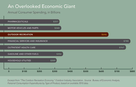
20130222OverlookedEconomicGiant.png
14

The Western Governors economic impact analysis also highlighted 35 recreational opportunities throughout the western states.   The overwhelming majority of these highlighted recreational locations involved the use of a dispersed trail network as part of the recreational experience. While many of these opportunities are outside areas to be designated habitat, analysis of these highlighted locations clearly evidences the critical role that the dispersed trail network plays in all recreational activities.

This research did identify other activities as larger economic contributors to western states, but these activities were not connected to public lands or small municipalities such as those impacted by the critical habitat designation. Western Colorado communities are simply not know as banking, health care or insurance centers of the western states.  They are however known for their exceptional recreational opportunities.  The  Organizations believe these findings warrant clear management standards that properly balance economic impacts from closures with benefits to the Grouse from the management standards.  Failure to properly measure and  balance all recreational interests will have profound effects on recreational access to public lands and will result in significant negative economic impacts to all communities that will do little to benefit the Sage Grouse.

5b.  Dispersed motorized recreation contributes over $1 billion a year to the Colorado economy.

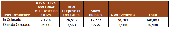
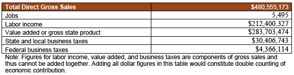
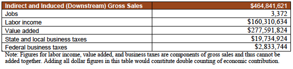
Recreational usage of public lands is a significant portion of the Colorado economy, especially in the smaller mountain communities which have already lost more traditional sources of revenue, such as timber, farming and mining.  In 2008, COHVCO commissioned an economic impact study to determine the economic impacts of OHV recreation on the Colorado economy.15  A copy of this economic impact study is attached for your reference.  This study found that over 1,000,000,000 dollars of positive economic impact and 10,000 jobs resulted from OHV recreation to the State economy.   Over $400,000,000 of this economic impact and almost 5,777 jobs were result from  motorized  recreation in the county areas proposed to be designated as critical habitat are located. 16  

In addition to this direct positive economic  impact to Colorado communities, OHV recreation accounted for over $100,000 million in tax revenue to state and local municipalities.17 These are tax revenues that motorized recreational users of the forest pay with little objection to obtain the benefits of their sport, and are used to address a wide range of needs for the local municipal government.  Given current economic conditions, our Organizations believe these positive economic impact numbers must be meaningfully addressed in all government activities.

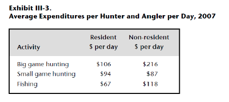
5c.  Colorado Parks and Wildlife identifies the significant positive impacts to the Colorado economy from hunting and fishing in Grouse habitat areas.

In 2008, Colorado Parks and Wildlife commissioned a study to determine the economic impacts to the Colorado economy from hunting and fishing.  A discussion of these impacts is provided as  a part of these comments in order to allow for full understanding and analysis of the significant impacts that are associated with the dispersed trail network in the areas to be designated as critical habitat.  Closures of dispersed trail networks are frequently of significant concern to those who use the dispersed trail networks for hunting and fishing activities. These impacts are not provided to open discussions regarding hunting of the Grouse, as the listing decision notes hunting of Grouse is Colorado has been properly prohibited for a significant period of time.  

The CPW report identified that hunting and fishing provided over $1.8 billion to the Colorado economy in 2008. 18   For many hunters and fisherman, motorized access on the dispersed trail network  is a key component of their hunting and fishing experience as the average hunter does not have access to  teams of horses to remove elk from inaccessible areas or days to hike into their local fishing area. These access related expenditures are encompassed in the CPW economic impact calculation  as analysis includes expenditures for trucks, campers, recreational vehicles, boats and other motorized equipment.19  Access related  expenditures that can only be fully utilized for hunting and fishing with the existence of a dispersed trail network.

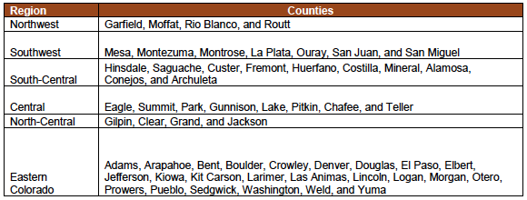
The CPW analysis also identified spending on hunting and fishing in the Colorado counties that are impacted by designations of critical habitat as follows:

2013-02-22Gunnison Sage Grouse.png

20

The Organizations believe that economic impacts from possible reductions in hunting and fishing activity in areas to be designated as critical habitat must also be accounted for in the development of management standards for the critical habitat.   As clearly identified by CPW, these economic contributions are significant and access is a key component of the hunting and fishing experience for most users.

6. The status proposal finds  OHV users are a highly law abiding user group on public lands, which conclusions are supported by recent CPW research.

The significant economic contributions provided to the Colorado economy from the dispersed trail network in proposed habitat areas warrants a serious review of all possible management strategies to address impacts to habitat areas before closures are adopted. As noted elsewhere in these comments, these steps would include moving to a limitation of use of existing routes in the habitat areas and reasonable sized seasonal closures.  The use of seasonal closures has been specifically identified as an effective tool for management of the dispersed trail network which results in  significant  protection of active leks.  

The Organizations are aware the effectiveness of  these changes would be heavily dependent on compliance with the restrictions by users.   Research indicates that users are highly compliant with seasonal closures and restrictions to existing routes.  The high level of compliance was  directly addressed in the status decision as follows:

“The BLM and Gunnison County have 38 closure points to minimize impacts to Gunnison sage-grouse within the Basin from March 15 to May 15 each year (BLM 2009, p. 40). While road  closures may be violated in a small number of situations, road closures are having a beneficial effect on Gunnison sage-grouse through avoidance or minimization of impacts during the breeding season.” 21

The Organizations are aware that limitations to existing routes and seasonal closures have been highly effective tools for addressing wildlife issues in other areas due to the high levels of user compliance with these type of restrictions.  These high levels of compliance are only briefly addressed in the status proposal but  more extensively  discussed in the findings of  the law enforcement pilot program developed by Colorado Parks and Wildlife to address alleged law enforcement concerns with OHV recreation.  This Pilot was developed in partnership with the Forest Service and Bureau of Land Management and is providing some of the first concrete information regarding compliance with use restrictions by those involved in OHV recreation.

The OHV law enforcement pilot program was created to address on-going assertions of a compelling need to stop resource damage caused by OHV misuse at locations identified as violation “hotspots” by those seeking to limit public access to public lands.  As part of the pilot program there were several targeted enforcement days in areas now proposed to be designated as grouse habitat, making  the pilot program findings highly relevant for user  compliance concerns in Grouse habitat areas.  The law enforcement pilot program deployed additional trained professional law enforcement officers, funded by funds from the OHV registration funds, to these “hotspots” during heavy usage times to supplement existing law enforcement resources in these areas.  As part of the pilot, the additional officers we required to keep logs of their contacts for reporting purposes.

The findings of this pilot clearly identify that these “hotspots” for OHV violations were anything but “hotspots”.  Over last two summers, officers involved in the pilot program contacted over 23,000 people of the 160,000 registered OHVs in Colorado, creating an astoundingly large sampling.  This pilot program found that less than 5% of riders committed any violations.   The overwhelming percentage of these violations were people not registering their OHV.  Only 1.8% of contacts involved activities, other than failing to register OHVs, where the officer found the activity serious enough to issue a written warning or issue of a citation for a resource impacting violation.

The Organizations believe the conclusions of this groundbreaking research are highly relevant to this discussion.  These findings will provide a high degree of reassurance to those with concerns about possible limited compliance with restrictions limiting improvements to Grouse populations and sage brush habitat.  These findings weigh heavily in favor of mitigating economic risks by only permitting use of existing trails and seasonal closures to protect active lek areas.

7a.  Decisions regarding the lack of impact of motorized recreation on the Greater Sage Grouse must be accounted for in habitat management.

As noted in the status proposal for the Gunnison Sage Grouse, the Greater Sage Grouse research remains relevant to the management of the Gunnison Sage Grouse.  The status decision clearly states:

“Gunnison sage-grouse and greater sage-grouse (a similar, closely related species) have similar life histories and habitat requirements (Young 1994, p. 44). In this proposed rule, we use information specific to the Gunnison sage-grouse where available but still apply scientific management principles for greater sage-grouse (C.urophasianus) that are relevant to Gunnison sage-grouse management needs and strategies….” 22

As previously noted in these comments, listing decisions relative to both the Greater and Gunnison Sage Grouse have explicitly found that recreational usage of Sage Grouse habitat is a low priority threat to the habitat.   While the FWS findings cited above do not specifically identify dispersed motorized recreation, they provide an extensive discussion of possible motorized recreational impacts prior to concluding that recreation has a minimal impact on the sage grouse.  The 2010 USFWS listing decision again stated that adoption of a designated trail system for recreational purposes is of significant benefit to the sage grouse.  The 2010 USFWS listing decision discussed changes to designated trails on USFS lands as follows:

“As part of the USFS Travel Management planning effort, both the Humboldt-Toiyabe National Forest and the Inyo National Forest are revising road designations in their jurisdictions. The Humboldt-Toiyabe National Forest released its Draft Environmental Impact Statement in July, 2009. The Inyo National Forest completed and released its Final Environmental Impact Statement and Record of Decision in August 2009 for Motorized Travel Management. The ROD calls for the permanent prohibition on cross country travel off designated authorized roads.” 23

Clearly, if the designated route system that was being adopted by these Forests was insufficient for the protection of Sage Grouse habitat, such a position would have been clearly stated in this discussion given the large body of research that exists for the management of the Sage Grouse.

7b.  Two recently released texts support FWS positions regarding the minimal risk recreational usage of habitat areas poses.

Two recently released texts from nationally acknowledged grouse experts have specifically addressed the management of Greater Sage Grouse habitat and included extensive discussions of all possible threats to  Grouse.24  The Organizations believe it is significant to note that the Sandercock text simply never addresses possible motorized recreational concerns in habitat areas. The Knick and Connolly text discusses  OHV recreation in a very  general manner  in two paragraphs of a text that totals 646 pages.25  This discussion only addresses trends in usage of OHVs.  These limited analysis is significant as these are resources one would expect to include significant discussions of OHV recreational impacts on the Grouse if these were significant concerns regarding OHV recreation creating possible impacts on the Grouse.

While these texts do not significantly address motorized recreation, the texts do specifically confirm access to public lands is a major issue for grouse management.  The Connolly text specifically states:

“Many people live in these locations primarily because of access to public lands for recreation.” 26

The Organizations must note the texts identification that living in an area primarily for access to public lands supports the Organizations concerns regarding  the type of impacts that must be balanced in the creation of management standards for critical habitat areas.

The Organizations are aware there is a significant body of peer reviewed research for the management of the Grouse.   The Organizations believe any concerns regarding dispersed recreation on the Grouse would have been identified in the current body of research summarized in these texts.  The Organizations believe the minimal discussion of this issue clearly supports the position that was taken in the 2010 Greater Sage Grouse listing decision, mainly that dispersed recreation is a minimal threat to the Grouse. As the benefits of a designated or existing trail system are approved in the listing decision and the minimal threat of impacts from motorized recreation is simply not discussed in two recent texts from National experts on the Grouse, the Organizations believe restricting travel to existing routes in Grouse habitat is a logical, scientifically based and credible starting point for addressing motorized access to critical habitat areas.

8a.  Restricting travel to existing routes would provide significant benefit for the Grouse with minimal economic risk in critical habitat areas.

The Organizations are intimately familiar with designations of routes under the Forest Service’s Travel Management rule. The Organizations would support limitations of travel to existing routes in critical habitat areas of the Grouse as part of a critical habitat designation.  As previously noted in the Greater Sage Grouse listing decision, a designated route system appears to be a significant benefit to maintaining sage grouse habitat and sage brush health. The Organizations believe these designations would be highly complied with if properly implemented, as most users are very familiar with requirements to stay on designated routes for travel as this is the common standard for dispersed route travel on public lands.

While the designation of travel routes is basically completed for Forest Service lands in the areas proposed to be designated Critical habitat for the Grouse, the designation process remains on going for many areas that are under BLM management.  This has resulted in large portions of the critical habitat not being currently subject to a requirement that travel is limited to existing routes.  The Organizations believe that restricting all travel to existing routes in habitat areas would provide significant benefit to the Grouse and the sage brush the grouse depends on for habitat, when compared to the current open area designations. The Organizations believe such a change could provide significant benefit to the Grouse with very little risk of negative economic impacts to local communities as recreational access and opportunities could be maintained. The Organizations believe the significant benefits that can be achieved for the Grouse at minimal costs weighs heavily in favor of meaningful analysis of limiting travel to existing routes as a method to preserve public access to the habitat areas.   

8b.  Use of seasonal route closures to avoid lek areas would minimize economic impacts.
As part of the travel management process, seasonal limitations on use of designated routes are frequently made to avoid wildlife habitat areas or to avoid sensitive areas at a particular times of the year for a particular species, such as spring closures of routes in elk calving areas.   These seasonal closures have been found to be highly effective in limiting impacts on wildlife during these sensitive periods and maintaining public access to these areas for the rest of the year when the species has moved from the area. In the case of elk calving areas, elk simply do not use calving areas in the summer as the elk traditionally move to higher areas for grazing purposes. As the elk have moved from these areas, use of routes in the area creates little to no risk of negative impacts to the animals.

Similar to elk, research indicates that sage grouse habitat and needs varies greatly over the course of a year.27  The habitat designation decision notes this highly seasonal mobility as follows:

“Gunnison sage-grouse make relatively large movements on an annual basis. Maximum Gunnison sage-grouse annual movements in relation to lek capture have been reported as 18.5 km (11.5 mi) (GSRSC 2005, p. J–3), and 17.3 km (10.7 mi) (Saher 2011,  pers. comm.), and individual Gunnison sage-grouse location points can be up to 27.9 km (17.3 mi) apart within a given year (Root 2002, pp. 14–15). Individual Gunnison sage-grouse have been documented to move more than 56.3 km (35 mi) to wintering areas in the Gunnison Basin in Colorado (Phillips 2011, pers. comm.). While it is likely that some areas encompassed within these movement boundaries are used only briefly as movement areas, the extent of these movements demonstrate the large scale annual habitat requirements of the species.” 28

Given the high levels of mobility displayed by the Grouse throughout the year, closing routes in all habitat areas would be problematic from an economic perspective. The overwhelming body of grouse research surrounds impacts and activities of the grouse in their lek areas, where population concentrations are highest and where the highest response to disturbance is identified. Research also indicates that lek areas are annually used for long periods of time  by the same group of Grouse.29 Discovery of new lek locations is a rather rare occurance and discovery of single new lek sites was of enough significance to warrant noting in the status decision.30  As researchers appear to have identified almost all lek areas in the critical habitat areas, this will make identification of routes around active leks in the critical habitat areas a management tool that could be quickly used to gain significant benefits to the Grouse.

Research indicates that seasonal closures for the protection of leks is a highly effective tool, which the status decision specifically notes as follows:  

“The BLM and Gunnison County have 38 closure points to minimize impacts to Gunnison sage-grouse within the Basin from March 15 to May 15 each year (BLM 2009, p. 40). While road  closures may be violated in a small number of situations, road closures are having a beneficial effect on Gunnison sage-grouse through avoidance or minimization of impacts during the breeding season.” 31

The Organizations believe that seasonal closures of routes will also only be effective if the nesting areas are seasonally closed to other uses as well.   Clearly closing a route to address concerns regarding its proximity to leks and nesting areas will not be effective if grazing, lek viewing  and other activities identified as similar or higher risk activities for the habitat areas  are continued.

9.   Recreational closures alone are insufficient to address habitat concerns.

As extensively noted in both the status and habitat proposals, there are a wide range of activities that are negatively impacting the Gunnison Sage Grouse, many of which are higher priority threats than recreational usage of the habitat areas. The following provisions are included in these comments to highlight some areas and activities that must also be addressed if large scale route prohibits are found to be required. It has been the Organizations experience with other endangered or threatened species that often isolation of a single usage to address impacts from a wide range of usages creates significant public opposition as users being restricted believe they are being singled out arbitrarily. Management decisions isolating single uses frequently fail and generate significant public opposition for future management of the issue.

The need to address a wide range of issues is supported in the status decision as closures of recreational access alone is insufficient to address habitat degradation, as the status decision specifically notes as follows:

“Based on modeling results demonstrating the effects of roads on Gunnison sage-grouse (Aldridge et al. 2011, entire—discussed in detail in Factor A), implementation of even the most restrictive travel management alternatives proposed by the BLM and USFS will still result in further degradation and fragmentation of Gunnison sage-grouse habitat in the Gunnison Basin.”  32

The Organizations vigorously believe that if access to any area is to be closed for recreational purposes, other higher priority threats must also be prohibited in that area, as research indicates recreational closures simply will never be sufficient to address  the wide range of activities that degrade habitat areas. The Organizations are vigorously opposed to any decisions to rely on a single activity to address the wide range of habitat issues, in light of the research that indicates prohibitions of that activity will simply never address the habitat issues contributing to the Grouse’s decline.

Several of the wide range of factors identified as habitat concerns are noted here as these issues would also have to be addressed  with closures to address the decline of the Sage Grouse, many of which are not related to recreational activities.  Dogs are a factor that significantly impairs habitat quality as noted in the status decision:

“Domestic dogs accompanying  recreationists or associated with residences can disturb, harass, displace, or kill Gunnison sage-grouse. Authors of many wildlife disturbance studies concluded that dogs with people, dogs on leash, or loose dogs provoked the most pronounced disturbance reactions from their study animals (Sime 1999  and references within). The primary consequences of dogs being off leash is harassment, which can lead to physiological stress as well as the separation of adult and young birds, or flushing incubating birds from their nest.” 33

The Organizations would be very opposed to any management standards for habitat areas that precluded motorized travel but continued to allow access for pedestrians with dogs as the listing decision specifically identifies similar levels of concern for these uses.

Grazing is also another usage of habitat areas that poses a similar level of threat to the habitat as roads.  This concern is summarized in the listing decision as follows:

“Livestock management and domestic grazing have the potential to degrade Gunnison sage-grouse habitat. Grazing can adversely impact nesting and broodrearing habitat by decreasing vegetation available for concealment from predators. Grazing also has been shown to compact soils, decrease herbaceous abundance, increase erosion, and increase the probability of invasion of exotic plant species (GSRSC 2005, p. 173).” 34

The Organizations must also note that lek viewing is currently not a significant issue for the Sage Grouse, however the Organizations believe that access to the lek area for viewing would create similar if not higher levels of disturbance to the Grouse when compared to a person simply passing through the area. The Organizations believe that if all recreational trail access is fully closed in an area then these activities should be prohibited as well.

The Organizations must again note that the above activities are not singled out due to heightened concerns for the activities but rather to briefly identify many of the usages that would need to be prohibited in a habitat area if the decision was made to permanently close the area to trail usage.   While these additional restrictions would create economic concerns, the Organizations believe these economic impacts would be balanced by the fundamental fairness of treating similar threats to the Grouse in a similar manner.   It has been the Organizations experience that arbitrarily permitting some uses while prohibiting others often fosters significant frustration from the public and develops little public support for conservation efforts.  Given the high levels of habitat areas that are in private lands, the Organizations believe public support will play a critical role in any long term recovery efforts for the Grouse.

10.  Conclusion

The Organizations believe that the protection of any endangered or threatened species is a critical part of federal land management.  Proper identification of the threats and issues causing any species to be endangered is critical to developing plans  that do not significantly adversely impact local communities  for the protection of that species.  There is simply no argument to be made that the dispersed trail network in the habitat areas is anything other than a significant economic contributor to local and state economies. The research on this issue is irrefutable.

The Organizations believe the significant economic impacts warrant serious analysis of every step possible to protect the trail network and meaningfully improve habitat  areas for the long term benefit of the Grouse.  The Organizations believe research concludes that moving to a designated trail system in habitat areas  would provide significant protection for the Gunnison Sage Grouse. The Organizations believe that limited size seasonal closures of routes adjacent to active lek areas would also provide significant benefits for the Grouse and protect the economic contributions to local communities from the dispersed trail networks.  Both of these management standards have been shown to be effective at protecting and improving Grouse habitat.

The Organizations would be vigorously opposed to any attempts to close routes prior to utilization of designated routes and seasonal closures in a habitat area. If closures of routes was found to be necessary, research concludes there are numerous other uses in habitat areas that pose similar or higher threats to the grouse than the dispersed trail network.  The Organizations believe all uses that pose threats to the Grouse must be prohibited if the dispersed trail network is closed.  Arbitrarily selected permitted and prohibited uses often does little to foster public support for the habitat management actions and given the high levels of private lands in habitat areas, the Organizations believe public support will be a critical component of habitat management moving forward.

Please feel free to contact Scott Jones at 518-281-5810 or by mail at 508 Ashford Drive, Longmont, Co 80504 for copies of any documentation that is relied on in these comments or if you should wish to discuss any of the concerns raised in these comments further.

Sincerely,
                    
John Bonngiovanni
Chairman and President
Colorado OHV Coalition

Don.E. Riggle
Director of Operations
Trails Preservation Alliance

Scott Jones, Esq.
COHVCO CO-Chairman

1Endangered and Threatened Wildlife and Plants; Designation of Critical Habitat for Gunnison Sage-Grouse;  78 Fed. Reg  2540 ( Jan. 11, 2013) at pgs 2552-2556. (hereinafter referred to as the “Habitat proposal”).

2Habitat Proposal at pg 2558.

3Endangered and Threatened Wildlife and Plants; Endangered Status for Gunnison Sage-Grouse; 78 Fed. Reg.  2486 (Jan. 11, 2013) at pg 2533. (hereinafter referred to as the “status proposal”)

4 Endangered and Threatened Wildlife and Plants; 12-Month Findings for Petitions to List the Greater Sage- Grouse (Centrocercus urophasianus) as Threatened or Endangered, Fed. Reg. (March 5, 2010) at Pg 75.

5Status proposal at pg 2499.

6Aldridge et al; Crucial Nesting Habitat for Gunnison Sage Grouse; A Spatially Explicit Hierarchical Approach; Journal of Wildlife Management; Vol. 76(2); February 2012; 391-406 at pg 404.

7Western Governors Association; Policy Resolution 11-9; Sage-grouse and Sagebrush Conservation; July 11, 2011 at pg 2.

8Humston et al; USFS Office of Rural Development; Jobs, Economic Development and Sustainable Communities Strategizing Policy Needs and Program Delivery for Rural California; February 2010 at pgs 51-52

9David Taylor; Economic Importance of the Winter Season to Park County Wyoming; University of Wyoming Press; 1999 @ pg 2.

10Cordell et al; USFS Research Station; Off-Highway Vehicle Recreation in the United States and its Regions and States: A National Report from the National Survey on Recreation and the Environment (NSRE) February, 2008; pg 56.

11Id at pg 56.

12 Id at pg 41-43.

13
Western Governors Association; Managing the Regions Recreational Assets; Report of the Get Out West Advisory Group to the Western Governors’ Association; June 2012 – pg 1.

14Western Governors Association; A Snapshot of the Economic Impact of Outdoor Recreation; prepared by Outdoor Industry Foundation; June 2012 at pg 1.

15COHVCO Economic Impact Study- 2008; Lewis Burger Group;  pg ES-5.

16
Id at ES-6.

17Id at pg ES-5.

18Colorado Division of Wildlife; Final Report; The Economic Impacts of Hunting, Fishing and Wildlife Watching in Colorado; Sept 26, 2008; at pg Exec Summary at pg 1.

19Id at Section 3 pg 10.

20Colorado Division of Wildlife; Final Report; The Economic Impacts of Hunting, Fishing and Wildlife Watching in Colorado; Sept 26, 2008; at pg Exec Summary at section 4 pg 16 & 17.

 21Status Proposal at pg 2532.

 22Status proposal at pg 2488
 
2312-month findings for petition to list the Greater Sage Grouse(Centrocercus urophasianus) as threatened or endangered.  Fed Reg. (March 5, 2010) at pg 92.
 
24Sandercock et al; Ecology, Conservation and Management of the Grouse; University of California Press 2011; see also ST Knick and JW Connolly (editors) Greater Sage Grouse; Ecology and conservation of a landscape species and its habitats. Studies in Avian Biology (vol 38), Univ of California Press, Berkeley CA.
 
25See, Knick and Connolly at pg 216.

26See, Knick and Connolly at pg 216.
 
27Connolly JW, ET Rinkes and CE Braun. 2011. Characteristics of Greater Sage Grouse habitats; a landscape species at micro- and macroscales. pg 69-83 in ST Knick and JW Connolly (editors) Greater Sage Grouse; Ecology and conservation of a landscape species and its habitats. Studies in Avian Biology (vol 38), Univ of California Press, Berkeley CA.

28Status proposal at pg 2543.
 
29Status proposal at pg 2488-2495.
 
30Status proposal at pg 2494.
 
31Status proposal at pg 2532 .

32Status proposal at pg 2526.

33Status proposal at pg 2532.
 
34Status proposal at pg 2505.
 
pdficon_large.gif Full letter

pdficon_large.gif Area Map


Continue Reading

Economic studies concerning the positive impact of OHV recreation

   
pdficon_large.gif

A Snapshot of the Economic Impact of Outdoor Recreation June 2012

A report documenting the income, tax revenue and the number of jobs created by outdoor recreation.
A collaboration of Outdoor Industry Association, The Outdoor Foundation, The Motorcycle Industry Council, The Specialty Vehicle Institute of America, The Recreational Off-Highway Vehicle Association, National Marine Manufacturers Association, and The Western Governors’ Association

pdficon_large.gif

Economic impact summary of GJFO proposal – GJFO horribly undervalues economic contributions of recreation
Document prepared by COHVCO & TPA

pdficon_large.gif

Colorado Off-Highway Vehicle Coalition – Economic Contribution of Off-Highway Vehicle Recreation in Colorado Executive Summary

Report created by the Colorado Off-Highway Vehicle Coalition on the Economic Contribution of Off-Highway Vehicle Recreation in Colorado
 

pdficon_large.gif

The Economic Impacts of Hunting, Fishing and Wildlife Watching in Colorado
Prepared for Colorado Division of Wildlife
Sept 26, 2008

Continue Reading

The TPA helps Exit Tours MC with start up funding

  
February 03, 2013
The Trails Preservation Alliance (TPA) recently donated a check for start-up funding to Exit Tours M/C in Salida, Colorado (a non-profit organization).

The donation will be use to promote Exit Tours M/C and the club’s aim to share riding experience with motorcyclists by sponsoring various events like Trail Rides, Dual Sport adventures and Adventure Tours in the Rocky Mountains.

In addition Exit Tours M/C will work with the United States Forest Service (USFS) and BLM on mutually beneficial projects and adopt and maintain trails in the National Forest.

Exit Tours M/C goal is to promote our sport, to provide motorcycle enthusiasts with knowledge and skills and to support the Colorado Off HighwayVehicle Coalition (COHVCO) and the TPA.

Exit Tours M/C web site:
coloradodualsport.com

Exit M/C on Facebook:
http://www.facebook.com/groups/exittoursmc


Continue Reading

2013 Trails Awareness Symposium

  
 February 01, 2013

The 2013 Colorado 600 Trails Awareness Symposium 2013 website is live…and registration is open!

2013ColoradoTPA.png

Ride dates for 2013 are Sept 7th – 11th

What is it?
The Colorado 600 is a five day ride and trail symposium through the mountains of southwestern Colorado.  Each day the riders will learn about what is facing the trail riding enthusiast and the issues facing our trails in Colorado and Utah. 

Riders are able to bring two or three bikes, giving them the option of single track, dual-sport or adventure trails.  You get to choose your ride for the day based on what you are in the mood for. 

All proceeds from the ride will go to support the Colorado Trails Preservation Alliance, a Colorado 501c3 non-profit. The newly-formed TPA is focused on preserving motorized, single-track trail riding

Sign up now!
www.Colorado600.org


Continue Reading