Archive | News

Red Cliffs/Warner Valley Land Swap Comments

COHVCO TPA CORE RWR MOAB Friend for Wheelin Colorado Snowmobile

Red Cliffs/Warner Valley Land Exchange
Bureau of Land Management
Stephanie Trujillo, Realty Specialist 3
45 East Riverside Drive
St. George, UT 84790

 Re: Red Cliffs/Warner Valley Land Swap Project #2022389/510

Dear Planning Team Members:

Please accept this correspondence as the vigorous input of the above Organizations with regard to Red Cliffs/Warner Valley Land Swap of the Organizations (“The Proposal”) identified above. The Organizations have been involved in discussions around access areas throughout the region for more than a decade, both in the development of travel and resources management plans. In addition to the planning efforts, our involvement has continued on behalf of recreation interests in litigation. We remain committed to this presence in ongoing management to protect the globally significant recreational values of Utah BLM lands. The Organizations must initially express shock that this Proposal has even reached scoping as there are SO many basic flaws with the Proposal. The Organizations vigorously assert the Proposal creates more issues than it solves. Many of these failures simply cannot be resolved within the scope of the Proposal, such as the complete imbalance of economic and resource values between the two parcels that are sought to be swapped. The proposed swap also creates many questions outside of the two parcels, mainly are there even parcels with similar resource values where the SRMA usage can be moved to; what are the benefits of these parcels where the SRMA be relocated to that would now have to be addressed; how would this relocation be funded; and what type of timeframe would this require. Even if OHV usage was allowed to remain in the area after the swap was undertaken, how would this usage align with domestic housing immediately adjacent?

Generally, the Organizations support resolution of all concerns created remaining from the creation of the Habitat Conservation Plan (HCP), but we do not believe the current Proposal would provide that type of resolution in any manner. The Organizations submit this Proposal would make the situation worse instead of better. Not only is the swap totally out of balance, the Proposal would force a user group, that has worked hard to partner with interests and move forward collaboratively to improve the community into an ever-smaller area of land despite decades of good faith efforts undertaken by numerous groups to avoid this type of impact. This situation would not resolve conflict, it would create significant conflict now and into the future as globally significant recreational opportunities would be lost and nothing would be provided in exchange. The Organizations submit that the small benefit to a single interest simply cannot be balanced in this situation.

1.      Who we are.

Prior to addressing the specific input of the Organizations on the Proposal, we believe a brief summary of each Organization is needed. The Colorado Off-Highway Vehicle Coalition (“COHVCO”) is a grassroots advocacy organization of approximately 2,500 members seeking to represent, assist, educate, and empower all OHV recreationists in the protection and promotion of off-highway motorized recreation throughout Colorado. COHVCO is an environmental organization that advocates and promotes the responsible use and conservation of our public lands and natural resources to preserve their aesthetic and recreational qualities for future generations. The TPA is an advocacy organization created to be a viable partner to public lands managers, working with the United States Forest Service (USFS) and the Bureau of Land Management (BLM) to preserve the sport of motorized trail riding and multiple-use recreation.

The TPA acts as an advocate for the sport and takes the necessary action to ensure that the USFS and BLM allocate a fair and equitable percentage of public lands access to diverse multiple-use trail recreational opportunities. Colorado Snowmobile Association (“CSA”) was founded in 1970 to unite winter motorized recreationists across the state to enjoy their passion. CSA has also become the voice of organized snowmobiling seeking to advance, promote and preserve the sport of snowmobiling through work with Federal and state land management agencies and local, state and federal legislators telling the truth about our sport. CORE is a motorized action group dedicated to keeping motorized trails open in Central Colorado and the region. Ride with Respect (“RwR”) was founded in 2002 to conserve shared-use trails and their surroundings. Ride with Respect (RwR) was founded in 2002 to conserve shared-use trails and their surroundings. Since then, over 750 individuals have contributed money or volunteered time to the organization. RwR has performed over 20,000 hours of high-quality trail work on public lands and participated in many planning efforts across Utah. Moab Friends-For-Wheelin’ (MFFW) is a non-profit club founded in 2005 to bring four-wheel drive enthusiasts together and promote the pastime of four- wheeling to the community as well as other enthusiasts. MFFW has volunteered thousands of hours and thousands of dollars to various projects such as trail maintenance and restoration, community service, and effective communication with other four-wheel drive organizations as well as public land managers. Collectively, TPA, CSA, CORE, RwR, MFFW and COHVCO will be referred to as “The Organizations” for purposes of these comments. While we are aware it is unusual for a snowmobile group to comment on a planning effort without snowmobile opportunities, this is an area of global significance to the recreational community and an overwhelming percentage of the international snowmobile community participate in motorized recreation in the summer. These opportunities are nationally recognized opportunities and draw users from all over the country.

2.   The History of the Parcels must be addressed.

 The Organizations are aware of the long and twisted history spanning more than 30 years that has resulted in the current land swap Proposal. The long history of this issue must be relevantly analyzed as the Proposal is doing more than merely protecting habitat and consolidating land management efforts. The entirety of the Proposal allows expansions of adjacent communities and infrastructure but has heavily impacting some private interests and heavily impacted legal users of public lands. Addressing the Proposal without understanding and recognizing the highly divergent path interests have taken subsequent to the Habitat Conservation Plan (HCP) and Congressional National Conservation Area (NCA) designation is troubling. The Organizations are also aware that many of these impacted interests have been provided opportunities to minimize or reduce impacts, such as through bankruptcy actions or land swaps or other efforts to balance interests and impacts. These opportunities have not been pursued.

The OHV community was heavily impacted by the original Tortoise HCP development to allow critical infrastructure for adjacent communities to develop while access to more than 60,000 acres of OHV opportunity area was lost in the HCP. Some of our impacts were mitigated by the additional protections for the Sand Hollow Area that were provided in planning, such as the SRMA designation for management of the area. The OHV community has chosen to accept this situation and move forward with opportunities still available. While the OHV community has chosen to move forward in partnership with communities, it would appear other interests have chosen to continue to pursue original attempts to create personal profits instead of benefitting the community. This is disconcerting as the beneficiary of the currently proposed land swap, who it is our understanding was a secured creditor who acquired title to significant portions of the parcels lost in the HCP in bankruptcy proceedings, is in such a position. The Organizations are aware that commercial lending efforts fail all the time and this is simply a cost of doing business. The Organizations can say with absolute certainty that creditors have a wide range of remedies in bankruptcy proceedings to protect their interests. It is only optional to acquire title to lands that are owned by the debtor, as any creditor can opt to be treated as an unsecured creditor in the proceeding. The creditor chose this path many years ago for reasons only they know, but the decision was theirs. On several occasions since this time, what would appear to be reasonable offers to resolve the creditors situation have been provided by governmental interests. These offers have consistently been declined to do asserted insufficiency by the creditor based on valuations that were highly speculative at best. This history is simply not accurately summarized as consolidation of ESA habitat and streamlining of management efforts.

It is from this position the Organizations would assert that the proposed land swap is a dreadful idea, as the swap would benefit an interest that has created many of their own problems and hugely impact another interest that has chosen to move forward with the post HCP landscape and improve recreation. The SRMA designation and Sand Hollow State Park would be an example of this type of collaboration. Moving this land swap forward is merely reopening old wounds for everyone and further impacts a community of interests that has worked to benefit everyone in the region that lost more resource value than the mere financial loss of the sole beneficiary of the swap. In a further twisting of an already painful situation many of the benefits that the developer is basing their land value on, such as the availability of the State Park to possible home sights, are only the result of subsequent collaborations undertake by the community. The Organizations submit that such a result would be completely unacceptable based on simple equity and while we understand the situation that the HCP has placed many interests in, replicating previous failures will not reduce problems in the long run but make them worse.

3.   Basic information in the scoping notice is not provided.

The Organizations are very concerned that basic information on many questions is simply not provided in the scope notice. Is the intent to perform an EA or EIS for this project? This is basic information that must be provided to the public to allow the public to meaningful comment as part of the scoping process. We vigorously assert that with the long and twisted history of the proposed swap the wide range of interests directly and indirectly impacted by the Proposal can only be addressed with an EIS.

4.  The comically imbalanced size of the parcels is problematic factually.

Prior to addressing the various legal requirements of a land swap to be complied with by the BLM, the Organizations must vigorously state that the proposal is simply shockingly out of balance in every way possible. Not only are the comparative sizes of the parcels out of balance, any factors that could be used to greatly increase the value of the smaller parcel are almost identical and, in many ways, the restrictions on usage drive the balance of values even further apart. Could we envision a situation where 85 acres of hugely valuable, accessible land would be a similar value to a much larger land locked inaccessible piece of land that could never be developed. We are unable to understand a market where this would be a viable position but it could happen.

Thankfully we are not in this situation as the size, access and developability of the parcels clearly favor the SRMA parcel. In the Proposal, market value factors such as this drive the values further apart, as the 85-acre parcel within the NCA (Hereinafter referred to as the NCA parcel.) is Congressionally prohibited from development and is functionally landlocked by other adjacent property interests. Roads simply could never be built to provide access without eminent domain of adjacent private property interests. This lack of access and Congressional Restrictions are the reason that the current owner of the property is seeking the transaction.

While the NCA is almost impossible to access legally and probably will remain so for the foreseeable future, the 1050 acres in the SRMA (Hereinafter referred to as the SRMA Parcel) is far more accessible. While the SRMA parcel does have issues of its own that would need to be resolved, these are significantly less than NCA parcel that are sought to be swapped. Again, questions of factual accuracy in market value must be reconciled, and based on the Scoping notice, we do not believe can be reconciled. Any assertion of equity would simply lack factual basis, even when allegations of ESA benefits are overly weighted. While many may assert ESA habitat is priceless this type of position is simply not factually viable.

The Organizations are aware there are extensive legal requirements that must be complied with in the planning efforts for the BLM addressing land swaps, withdrawals and disposals even for the alleged benefit of endangered species. These legal requirements are generally summarized as asking if the swap is in the public good? Identifying the public good extends far beyond mere economic values. When these requirements are reviewed in detail, these requirements are a major barrier to the Proposal as many of the reasons that are sought to be negatively impacting the NCA parcel would also greatly diminish the value of the SRMA parcel sought to be swapped. While certain interests would like to base the swap on previous values of the NCA parcel due to its possible development value at that time and prior to infrastructure changes and development flexibility that improved the SRMA parcel, this is simply not realistic. Time has passed and decisions have been made but statutory requirements require equality of market value.

Federal law clearly identifies that market value at the time of the swap, withdrawal or disposal, is the standard of comparison for equality of values. The Code of Federal Regulations clearly outline the provisions on the market value provide as follows:

“(a) In estimating market value, the appraiser shall:
3) Include historic, wildlife, recreation, wilderness, scenic, cultural, or other resource values or amenities that are reflected in prices paid for similar properties in the competitive market;”1

Throughout the long history of these parcels, having the parties come to any type of agreement on the value of the parcels to be withdrawn and disposed of has been a major challenge. The Organizations vigorously assert that normal market factors such as water and electricity, and rights of way to access the NCA parcel are HUGELY speculative at best after the NCA passage. Recreational economic values are well established and are protected by the RMP. Even without the RMP provisions, there are no Congressional restrictions in place on the SRMA parcel making this parcel FAR more valuable than the NCA parcel when comparing an acre for acre type of exchange. This imbalance is a problem that simply could not be resolved sufficiently in the current proposal to allow the exchange to move forward.

5(b). Identified resource values are badly out of balance and could not be corrected without passing more federal laws.

Federal regulations require review of swaps to determine if the public good is advanced by the swap. As the Organizations have noted previously, we have major concerns over the inequality of the economic valuation of the Proposal. Our concerns expand significantly when the resource value of these parcels is compared as the NCA parcel has marginal values at best to the public while the SRMA parcel has immense value to the public as it is a globally recognized recreational destination. Many in the OHV community would correctly assert the SRMA parcel provides recreational opportunities that are priceless in Southern Utah, given the many political developments that have occurred since the original designation of the HCP. We have to believe many of the recreational boat users on the adjacent reservoir would assert their recreational values are priceless as well and those boating interests could be negatively impacted by the swap as well.

The CFR provides a very broad definition of resource values as follows:

“Resource values means any of the various commodity values (e.g., timber or minerals) or non-commodity values (e.g., wildlife habitat or scenic vistas), indigenous to particular land areas, surface and subsurface.”2

Again, the Code of Federal Regulations requires resource values to be reviewed in determining the value of the public interest in any disposition or exchange as follows:

Determination of public interest. The authorized officer may complete an exchange only after a determination is made that the public interest will be well served. When considering the public interest, the authorized officer shall give full consideration to the opportunity to achieve better management of Federal lands, to meet the needs of State and local residents and their economies, and to secure important objectives, including but not limited to: Protection of fish and wildlife habitats, cultural resources, watersheds, wilderness and aesthetic values; enhancement of recreation opportunities and public access; consolidation of lands and/or interests in lands, such as mineral and timber interests, for more logical and efficient management and development; consolidation of split estates; expansion of communities; accommodation of land use authorizations; promotion of multiple-use values; and fulfillment of public needs. In making this determination, the authorized officer must find that: In making this determination, the authorized officer must find that:

(1) The resource values and the public objectives that the Federal lands or interests to be conveyed may serve if retained in Federal ownership are not more than the resource values of the non-Federal lands or interests and the public objectives they could serve if acquired, and

(3) The intended use of the conveyed Federal lands will not, in the determination of the authorized officer, significantly conflict with established management objectives on adjacent Federal lands and Indian trust Such finding and the supporting rationale shall be made part of the administrative record.”3

BLM regulations explicitly require the ability of the public to access parcels to be addressed as part of the determination of resource value as follows:

“Access
Evaluate the need to reserve public access, easements, or other access rights on the Federal land. This is critical information that the ASD appraisal staff needs to arrive at a market value opinion. Access, or lack thereof, may also be an important factor to address as part of considering the merits of the resource values and public benefits.”4

Given the numerous factors that the CFR requires to be balanced in determining the public good, any assertion of the Proposal merely addressing Tortoise habitat and ease of management interests is problematic. In reviewing these requirements, there can be no argument that the Proposal is badly out of balance in addressing resource values such as recreation and multiple uses and should not proceed merely based on the imbalance of the public interest in the transaction. While the transaction may benefit a small parcel owner in the NCA, the loss of the SRMA parcel would reopen old issues for a huge portion of the community and create long term conflict between the users of public lands and subsequent home owners that many never be able to be resolved while closing recreational values that are globally valued. There is simply no way that the NCA parcel could ever be thought to have the same resource value as the SRMA parcel that is sought to be exchanged. Even if the resource value for Desert Tortoise is reviewed in isolation, the value of the NCA Parcel as desert tortoise habitat is badly out of balance when compared to the Desert Tortoise habitat on the SRMA parcel that would be lost if these areas were developed into homes.

5(c) Legal protections for recreation and species habitats must be addressed as well in determining the public benefit.

When the Congressionally protected resource values of the two parcels are compared, there is a horrible imbalance as well as habitat for the Tortoise has been subsequently increased in value with the designation of the NCA. The Organizations are also aware that the initial protections against developments provided for in the HCP have expanded into Congressional Protection against those types of activities as the HCP was converted to a National Conservation Area with the Passage of the Omnibus Lands Bill of 2009. This legislation created the Red Cliffs National Conservation Area.5 It is the Organizations vigorous assertion that the SRMA parcels protected uses result in any attempt to bring balance to NCA parcel that prohibits this usage entirely a factual impossibility.

The Code of Federal Regulations describes in great detail how Congressional designations must be addressed in any land swap as follows:

“Congressional designations. Upon acceptance of title by the United States, lands acquired by an exchange that are within the boundaries of any unit of the National

Forest System, National Park System, National Wildlife Refuge System, National Wild and Scenic Rivers System, National Trails System, National Wilderness Preservation System, or any other system established by Act of Congress; the California Desert Conservation Area; or any national conservation or national recreation area established by Act of Congress, immediately are reserved for and become part of the unit or area within which they are located, without further action by the Secretary, and thereafter shall be managed in accordance with all laws, rules, regulations, and land use plans applicable to such unit or area.”6

BLM regulations implementing these CFR provisions expand on the requirements surrounding withdrawal of areas with special use designations as follows:

“4. Conformance with Land Use Plans. The decision must include a land use plan(s) conformance determination supporting the disposal of the Federal land and acquisition of the non-Federal land (43 CFR 2200.0-6(g)). It is often appropriate to also summarize from the environmental documentation how the decision interfaces with state and local land use plans.”7

The NCA designation made by Congress specifically identifies how motorized vehicles may be used in the NCA as follows:

(3) MOTORIZED VEHICLES. —Except in cases in which motorized vehicles are needed for administrative purposes, or to respond to an emergency, the use of motorized vehicles in the National Conservation Area shall be permitted only on roads designated by the management plan for the use of motorized vehicles.8

While motorized usage is allowed in the NCA it is at a very low density and only on roads. Open riding designations are prohibited by Congress.

When the significant recreational restrictions of the NCA are compared to the SRMA designations the conflict is immediate. The intended recreational usage of SRMA is clearly laid out in the BLM St. George Field Office RMP as follows:

“a) BLM will work with local and state agencies in developing recreation plans for lands surrounding the proposed Sand Hollow reservoir once it is constructed. Such plans may provide for staging areas, parking, information displays, and other visitor facilities needed to accommodate increased recreation and OHV use expected to occur throughout the immediate area.” 9

The St. George FO RMP takes the additional important step of clarifying why the SRMA designation is being put in place as follows:

“e) Generally, lands within this SRMA not already identified in this Plan for disposal or included in current exchange agreements will be maintained in public ownership to provide long-term stability for user groups such as the OHV community who, as a result of urbanization and land use restrictions, have lost much of their traditional open use areas.”10

The protections of multiple uses initially provided by the SRMA designation were then further implemented in partnership with the community and Utah State Parks, which resulted in the Sand Hollow State Park. The elevation of all forms of multiple use recreation at somewhat intense levels, is specifically identified in the State Parks Management plan for sand hollow as follows:

“The BLM’s St George Resource Management Plan recognized that Sand Hollow State Park could serve as a staging area for equestrian and off-highway vehicle (OHV) use on the BLM lands. The BLM contributed funds for the construction of a staging area near the access tunnel for OHV users, the Sand Pit campground, three day-use sites with restrooms, and a maintenance building. These facilities, along with facilities already built and funded by the Division and WCWCD, were identified as needs in the 2001 management plan.”11

The hugely successful nature of the multiple use nature of the park to local communities is clearly demonstrated by the following statement in the 2010 Sand Hollow State Park RMP as follows:

“Data collected at the park show that Sand Hollow State Park receives between 150,000 to 200,000 visitors annually. The park has been popular with local residents since its opening in 2003.”12

The Organizations vigorously assert that the resource values identified for the NCA area and SRMA area are utterly unreconcilable in terms of experience for the recreational users. These values have been repeatedly identified, planned for and protected in the SRMA parcel for decades. The value that the local communities have placed on these opportunities is clearly identified by the large numbers of visitation to the State Park since its inception. These visitation numbers have continued strong growth trends as Sand Hollow State Park is now a globally recognized recreational opportunity. These levels of activity would be entirely inconsistent with the NCA requirements for exceptionally limited levels of visitation on the management of the NCA parcel.

6.   Is the SRMA parcel even legally available for the swap to occur?

The Organizations are aware that portions of the SRMA were identified by the BLM in the St George RMP as available for possible disposal as required by various federal legal requirements. It is our position that the long-term lease of the area by the State of Utah has satisfied this possibility of disposal. The Organizations must question any assertion that once a parcel is identified for possible disposal does not mean the parcel remains available for repeated swap until the next RMP is completed. The Organizations submit that once a swap is undertaken the ability to dispose of the parcel has been removed until there is some reason to review the status of the decision, such as the termination of a lease or a significant change in condition in the area.

We are aware that Courts have taken a very broad interpretation of the availability of lands for disposal under the Recreational Purposes Act. Courts have found that the mere inventory of the parcel for possible wilderness designation is sufficient to stop withdrawal of the lands. 13 The Ninth Circuit held as follows:

“The Recreational and Public Purposes Act provides: “The Secretary of the Interior upon application filed by a duly qualified applicant … may … dispose of any public lands to a … county … for any public purposes  ” 43 U.S.C. § 869. The Government argues that the court should not order conveyance because section 869 vests discretion in the Secretary whether to convey lands, even when the lands are eligible and a qualified applicant has applied for them. We need not decide whether the Secretary has unfettered discretion under section 869. It is clear that Congress, in providing that the Secretary “may” dispose of lands, granted him some measure of discretion. Therefore, our review of the BLM’s decision not to grant the County’s application is limited to a determination whether it was an abuse of discretion. 5 U.S.C. § 706(2)(A).

In this case, the BLM did not abuse its discretion in deciding to await Congress’ determination of wilderness status. It would undermine the statutory scheme relating to potential wilderness lands to hold that the Secretary had to grant the County’s application here. The district court’s decision not to order conveyance must be affirmed.”14

The Organizations can see no reason why this broad scope of authority would change based merely on the reasoning for the decline to undertake the land swap. Clearly the long-term lease of any portion of the parcel, in a manner consistent with statutory requirements, to be withdrawn is a more significant interest in the property than a possible Wilderness designation at some time in the future. The Organizations would vigorously assert that BLM should state the lands are no longer available for swap and simply move on. There are simply too many other competing interests for BLM time and resources to even review the swap as it lacks community support, a clear public interest and only benefits a very small portion of the community.

7.   The chilling effect on the BLM ability to lease lands will be negatively impacted by closing a state park that was functionally just completed.

 The Organizations would urge the BLM to take a much longer interpretation of benefits of the swap being in the public interest and review the long-term impacts to BLM operations in the region more generally. The Proposal will have a major chilling effect on the BLM’s ability to undertake any land swap The Proposal will simply set a HORRIBLE precedent on the value of planning and agreements on major projects, such as long-term leases of lands with the BLM. The Organizations believe this issue alone should be the basis for concern and declining to pursue the Proposal as the Proposal would significantly alter the access to a State Park that was developed in partnership with BLM very recently. This initiative took years of volunteer effort and significant funding to be completed as entirely based on the defensibility of the terms of the lease for the State Park lands. The State of Utah has developed an extensive plan for the long-term sustainable use and development of this park in a manner consistent with the SRMA. These are relationships that would have irreparable harm done to them if the Proposal were to move forward.

The Proposal takes these years of effort and significant funding and voids that effort. This will have a huge chilling effect on any groups that may seek to develop similar resources based on long term leases with the BLM throughout the region. Why would other users or interests undertake such an effort if the benefits of this effort could be removed at any time?

8.   Conclusion.

The Organizations must initially express shock that this Proposal has even reached scoping as there are SO many basic flaws with the Proposal. The Organizations vigorously assert the Proposal creates more issues than it solves. Many of these failures simply cannot be resolved within the scope of the Proposal, such as the complete imbalance of economic and resource values between the two parcels that are sought to be swapped. The proposed swap also creates many questions outside of the two parcels, mainly are there even parcels with similar resource values where the SRMA usage can be moved to; what are the benefits of these parcels where the SRMA be relocated to that would now have to be addressed; how would this relocation be funded; and what type of timeframe would this require. Even if OHV usage was allowed to remain in the area after the swap was undertaken, how would this usage align with domestic housing immediately adjacent?

Generally, the Organizations support resolution of all concerns created remaining from the creation of the Habitat Conservation Plan (HCP), but we do not believe the current Proposal would provide that type of resolution in any manner. The Organizations submit this Proposal would make the situation worse instead of better. Not only is the swap totally out of balance, the Proposal would force a user group, that has worked hard to partner with interests and move forward collaboratively to improve the community into an ever-smaller area of land despite decades of good faith efforts undertaken by numerous groups to avoid this type of impact. This situation would not resolve conflict, it would create significant conflict now and into the future as globally significant recreational opportunities would be lost and nothing would be provided in exchange. The Organizations submit that the small benefit to a single interest simply cannot be balanced in this situation.

If you have questions, please feel free to contact Scott Jones, Esq. (518-281-5810 / scott.jones46@yahoo.com), Chad Hixon (719-221-8329 / chad@coloradotpa.org), or Clif Koontz (435- 259-8334 / clif@ridewithrespect.org).


Scott Jones, Esq.
CSA Executive Director
COHVCO Authorized Representative

Chad Hixon
Executive Director
Trails Preservation Alliance

Clif Koontz
Executive Director
Ride with Respect

Marcus Trusty
President/Founder
Colorado Off Road Enterprise

Jeff Stevens
President
MOAB Friends for Wheelin


1 See, 43 CFR 2201.3-2

2See, 43 CFR 2200.0-2(u)

3 See, 43 CFR 2200.0-6(b)

3 See, 43 CFR 2200.0-6(b) 4 See, BLM manual H-2200-1 LAND EXCHANGE HANDBOOK at pg. 6-6.

5 See, §1974 of Public Law 111-11

6 See, 43 CFR 2200.0-6f

7 See, H-2200-1 Land Exchange Handbook pg. 9-3

8 See, Public Law 111-11; Omnibus Lands Bill of 2009 @ §1974 (e)(3)

9 See, St. George BLM Field Office Resource management plan; March of 1999 at pg. 2-42

10 St George FO RMP at pg. 2.42

11 See, Utah State Parks; Sand Hollow State Park Resource Management Plan; April 2010 at pg. 15.

12 See, Utah State Parks; Sand Hollow State Park Resource Management Plan; April 2010 at pg. 15.

13 See, Humboldt County v US; CA Nev. 1982; 684 f2d 1276(1982)

14 See, Humboldt County at pg. 1285.

Continue Reading

Recreational Trails Program – Letter of Concern

Federal Highways Administration
Via Portal @ http://www.regulations.gov, Docket: DOT-OST-2022-0124.

RE: Notice of Proposed Waiver of Buy America Requirements for De Minimis Costs, Small Grants, and Minor Components – Docket # DOT-OST- 2022-0123

Dear Sirs:

Please accept these comments as a supplement to the comments submitted by the Organizations regarding the original proposal and its relationship to the Recreational Trails Program. (“RTP”).  As such we are not repeating our Organizational specific descriptions as you are aware of our general Organizational missions.  We are also aware that many of our groups are also working with their state RTP program managers in development of additional state comments. Our membership has participated in almost every phase of the RTP process, from developing grants, to scoring grants, to meeting with legislators to obtain full funding for the RTP program. While we are aware that this comment period is limited to manufactured products, we are addressing the entirety of our concerns around the BABA Proposals. Part of our concerns center on the fact that in defining manufactured products as a portion of an entire project, significant complications can arise. The Organizations must address a preliminary concerning the scope and basis for waivers for the RTP program generally.  The public interests and benefits of the RTP program have been repeatedly and strongly identified by Congress since its inception in 1991 and as a result the Organizations must question. The RTP program is rather unique in federal highways programs as it is funded through the federal highway users fuel taxes but is managed with objectives now identified for the National Park Service.  While the management may be shared for the program, the waiver authority is based on the funder of the program, so the NPS lacks authority to issue such a waiver.  The Organizations believe the long and specific history of the Congressional findings for the RTP program warrant a waiver be issued on a public interest basis as well as the other statutory basis outlined previously.

The Organizations are concerned that the historical strength of the RTP Program has been its flexibility in creating public benefit in a wide variety of ways such as directly tangible benefits, such as buying equipment or supplies and the fact that the granting process is reasonably flexible.  RTP also provides significant less tangible benefits such as getting underserved youth populations outside and engaged in public stewardship. These are components of the RTP program that are rather unique within the scope of FHWA operations. While the Organizations support BABA, we are also aware that FHWA has provided VERY limited waivers for BABA and previously Buy American standards when compared to other agencies.  This has proven to create significant friction between local administrators, grant managers and grant applicants.  It would be the Organizations desire that the BABA provisions are developed in a manner that reduces conflict rather than expands it.

The Organizations are also aware that the Made in America Office (“MAIO”) is being formed currently. Given that the MAIO is seeking to achieve consistency and timely issuance of waivers and processes across agencies.[1] The Organizations submit that the creation of the MIAO should be a concern as FHWA policy appears to significantly conflict with one of the premises of the office, mainly that waivers are available for projects and efforts.   We would urge FHWA to be consistent as much as possible with other agencies simply for efficiencies, this type of consistency will be important for the small nonprofits that are commonly applying for these grants. They simply lack the time and resources to adjust projects midstream due to changes in accounting and grant administration guidance.

1(a) Congress has specifically recognized the public benefit of the Recreational Trails Program for decades.

The Organizations must address the rather unusual nature of RTP within Federal Highways as this unique status is highly relevant to our comments.  RTP is a comanaged FHWA program managed to US Park Service goals and objectives, with the funding stream coming from the federal highways fuels taxes. While the program maybe comanaged with NPS, waivers are issued by the funding agency and as a result must be issued by FHWA.

The Congressional findings regarding the RTP program are highly relevant to the public interest waivers that can be issued under the Infrastructure Act.  RTP was originally enacted by the Intermodal Surface Transportation Act of 1991, which clearly laid out Congressional findings regarding the public benefits of RTP Program as follows:

“(a) IN GENERAL.—The Secretary, in consultation with the Secretary of the Interior, using amounts available in the Fund, shall administer a program allocating moneys to the States for the purposes of providing and maintaining recreational trails.”[2]

The Intermodal Surface Transportation Act of 1991 also specifically identified that the goals of the RTP program were to be managed to the goals and objectives established in the Statewide Comprehensive Outdoor Recreation Plan required by the Land and Water Conservation Funds.  The LWCF program is administered through the National Park Service to the goals and objectives of the SCORP.  The mandatory nature of this co-management relationship is outlined as follows:

(b) STATEMENT OF INTENT.—Moneys made available under this part are to be used on trails and trail-related projects which have  been planned and developed  under the otherwise existing laws, policies and administrative procedures within each State, and which are identified in, or which further a specific goal of, a trail plan included or referenced in a Statewide Comprehensive Outdoor Recreation Plan required by the Land and Water Conservation Fund Act.[3]

When the Land and Water Conservation Fund was established in 1964, Congress clearly and directly the LWCF program has Congress clearly identified their findings of the Program serving the public interest in §460l of the Act as follows:

“Congressional findings and declaration of policy. The Congress finds and declares it to be desirable that all American people of present and future generations be assured adequate outdoor recreational resources, and that it is desirable for all levels of government and private interests to take prompt and coordinated action to the extent practicable without diminishing or affecting their respective powers and functions to conserve, develop and utilize such resources for the benefit and enjoyment of the American People.

The clear Congressional findings regarding the compelling public interests served by the LWCF program were repeated in 460l-4 as follows:

“§460l–4. Land and water conservation provisions; statement of purposes

The purposes of this part are to assist in preserving, developing, and assuring accessibility to all citizens of the United States of America of present and future generations and visitors who are lawfully present within the boundaries of the United States of America such quality and quantity of outdoor recreation resources as may be available and are necessary and desirable for individual active participation in such recreation and to strengthen the health and vitality of the citizens of the United States by (1) providing funds for and authorizing Federal assistance to the States in planning, acquisition, and development of needed land and water areas and facilities and (2) providing funds for the Federal acquisition and development of certain lands and other areas.”

In 2014 the historical findings of Congress regarding LWCF and RTP was consolidated into 54 USC 200101[4], which again reaffirmed the Congressional findings of a public benefit if the LWCF and RTP programs as follows:

“Congress finds and declares it is desirable—

(1) that all American people of present and future generations be assured adequate outdoor recreation resources; and

(2) for all levels of government and private interests to take prompt and coordinated action to the extent practicable without diminishing or affecting their respective powers and functions to conserve, develop, and utilize those resources for the benefit and enjoyment of the American people.”

In this update and clarification of numerous statutory requirements affecting the NPS, Congress also clearly stated their intent in undertaking this revision and clarification as follows:

“…the intent is to conform to the understood policy, intent, and purpose of Congress in the original enactments, with such amendments and corrections as will remove ambiguities, contradictions, and other imperfections…”[5]

The Organizations vigorously assert that the provisions of 54 USC 200101 were strengthened by Congress in response to the almost ongoing addition of programmatic barriers and additional documentation on many of the programs covered by these provisions.  These barriers had resulted in some rather public failures of the Agency to provide basic service and this revision was created to assure this did not happen again.  Again, we submit that the RTP program specifically, and the LWCF program also, were created with a specifically identified public benefit and as a result should be provided a waiver simply based on the public benefit waiver identified in Infrastructure Act.  The Organizations are unable to envision how a waiver for of the RTP program would not be within the scope of a government action to conserve, protect and utilize the RTP program benefits previously provided in 54 USC 200101.

The Organizations must identify the immense amount of overlap between the RTP/LWCF management issues that were addressed with Public Law 113-287 and strengthening of 54 USC 200101 and the concerns that are to be addressed with the issuance of waivers under the Buy America provisions of the Infrastructure Act. The basis for FHWA issuance of public interest waivers is clearly identified by the OMB Memo m-22-11 as follows:

“Public Interest Waivers

A waiver in the public interest may be appropriate where an agency determines that other important policy goals cannot be achieved consistent with the Buy America requirements established by the Act and the proposed waiver would not meet the requirements for a nonavailability or unreasonable cost waiver. Such waivers shall be used judiciously and construed to ensure the maximum utilization of goods, products, and materials produced in the United States.33 To the extent permitted by law, determination of public interest waivers shall be made by the head of the agency with the authority over the Federal financial assistance award.34

Public interest waivers may have a variety of bases. As with other waivers, they should be project-specific whenever possible, as what is in the public interest may vary depending upon the circumstances of the project, recipient, and specific items, products, or materials in question.

Federal agencies may wish to consider issuing a limited number of general applicability public interest waivers in the interest of efficiency and to ease burdens for recipients. The agency remains responsible for determining whether such a waiver is appropriate to apply to any given project: the Made in America Office will not review each application of such a waiver.”[6]

It is significant to note that there are no prohibitions on the issuance of waivers, and compared to previous guidance the OMB process outlines is a relaxed standard for the issuance of waivers.  The OMB memo further outlines several other basis for waivers that would be at least partially applicable to the RTP program. Given the repeated Congressional recognition of the immense public interests that flow from the RTP program generally and the compelling need to avoid governmental barriers to its application, the Organizations vigorously assert the RTP program has a very strong Congressional provision for the issuance of the waiver. Without the issuance of a public benefit waiver, the RTP program would be in direct violation of existing Congressional mandates to streamline the administration of the RTP and LWCF programs.

1(b)The RTP program provides unique public benefits to communities which Congress has previously sought to protect from undue barriers to the Program’s implementation.

The Organizations are aware that almost every project that FHWA is involved with provides some level of public benefit but almost none of these efforts are comanaged with the National Park Service or subject to the provisions of 54 USC 200101.  The RTP program is unique in that the level of public benefit that is provided.  While the awareness of RTP efforts to maintains trails is one of the cornerstones of the RTP program, the indirect public benefits of the program extend further than just trail maintenance. The RTP program gets underserved communities outside, engages with the Youth Corp to use these resources to maintain public access.  Very few FHWA can identify this type of benefit from their efforts.

The RTP funding program also provides significant fire protection to western communities as these routes that are maintained are also providing access for fuels mitigations and firefighting efforts.  This benefit is immense as hotshot crews are able to engage with firefighting activities and not have to cut trails and roads open to get to the areas where they need to be working.  RTP provides resources that firefighters are not able to develop in their timeframes, such as bridges over creeks and mapping resources.  RTP can provide a bridge that allows firefighters to simply get closer to the areas they need to be working in.  Building bridges simply is not a viable tool for firefighters who are engaged in responding to a wildfire.

Again the Organizations must note that the strength of the RTP program extends far beyond normal FHWA concerns and any overhead is simply not an additional cost that can be carried through.  These are highly competitive projects and efforts that are driven by volunteers and include concerns such as engaging youth corps and underserved communities.  RTP can continue to serve as a catalyst for development of nonprofit partners to leverage RTP funds or it can serve as a barrier to the existence of these groups. We vigorously urge FHWA to allow RTP to continue to serve in its intended role with the issuance of waivers for projects that allow organizations to continue to function.

1(c)  RTP is a catalyst for on the ground efforts that benefit the public.

The Organizations are also aware that programmatic motorized partner funding for RTP funds was developed far before RTP was ever imagined.  The same cannot be said for non-motorized activities throughout the Country. We are aware that many focused on nonmotorized efforts are continuing to see the RTP as a catalyst for other efforts. As an example, recently Great Outdoors Colorado announced another $500k in grant funding to leverage the RTP funds in an attempt to stimulate the development of non-motorized crew maintenance efforts similar to the motorized efforts already in place. The availability of RTP money has been an effective catalyst in development of efforts such as this and these efforts cannot be overlooked. While the voluntary registration programs that leverage the motorized portions would continue to function, albeit at a lower funding level, matching efforts such as this would become problematic in the long term as there was no other funding source that would be matched.

The programmatic efforts that have been driven in part by the RTP program are immense, on the motorized side of the Program as many states developed a State OHV registration program either as RTP was being developed or in direct response to the RTP program.  These programs have now far exceeded the value of RTP funding in many states. Many other states have not adopted this model and RTP remains the sole source of funding for motorized activities.  The Organizations hope that the RTP program will continue to serve as an inspiration in these states to take up this model at some point in the future.

2. Tiny projects by FHWA standards are consistently funded and can make a huge difference on the ground.

As the Organizations have noted, many of the public benefits resulting from the RTP Program are unusual in comparison to traditional Federal Highways Projects.  The Organizations are aware that our original submissions were generally focused on the motorized side of the RTP Program, and with these comments we are going to be focused on certain aspects of the non-motorized portions of the RTP program. The Organizations believe it is important to identify that RTP program funds are applied on the allocation of 30% of funding is used for motorized projects, 30% is applied to non-motorized projects and the remaining 40% is applied for diverse projects.  The non-motorized portions of the program are very different in terms of model and function on how the RTP funds are applied on the ground for a variety of reasons, including limited matching funds being directly available and different scopes of funding and resources for projects, and where the projects are even located.

The Organizations are intimately familiar with the exceptionally small size of some projects that are funded through the RTP programs and we can say with absolute certainty that these small grants are some of the most satisfying and effective grants the program receives for everyone involved.  With these small grants, huge benefit to communities can be easily achieved with exceptionally small amounts of money. The Organizations are intimately aware of the fact that every year there are great projects in all phases of the RTP program that are valued at far less than $50k and we are not aware of grants that exceed the minimum acquisition thresholds being funded. The Organizations vigorously assert that it is due to the exceptionally small size of the RTP program, and the even smaller size of these grants is the basis for the Congressional mandate in 54 USC 200101.  The benefits of these efforts are huge and benefit all the public and are provided generally by small nonprofit partners that often simply are unable to absorb any costs or delays in their grant funding.  There is often no other funding for projects available and these groups lack funding to bridge funding shortfalls. Compounding the need for the RTP funding is the fact that an overwhelming portion of these funds are used on federal public lands in an attempt to address huge budget shortfalls for these federal lands managers.

As we have noted, many of the RTP grants provided are exceptionally small, but we are also aware that some samples of grants provided will help clarify these concerns.  These are not large multinational corporations frequently found in FHWA projects but tiny organizations working on public lands to protect resources and improve recreational opportunities for everyone. We have provided a chemical toilet rental grant from the Columbine Ranger District on the Arapahoe Roosevelt National Forest in Colorado, which was funded but only cost $9,000.[7]  While this grant may be small, the benefits to the recreational community and the local community are overwhelming.  This grant will allow a trailhead that has been simply overwhelmed with visitation to remain open and providing quality recreational facilities. Local community members will hugely benefit from a clean and neat trailhead and no longer having to pick up human waste from visitors that were not able to use the current toilets that had just been overwhelmed and were forced to use other less acceptable resources. By providing management and resources for this area, natural resources are protected as the unmanaged human waste is not flowing into local aquifers, and other areas that are totally unacceptable.  If there was ever a project in the public interest, this would be a perfect example.   Our first reason for including in the comments is the exceptionally small size of the grant. There is only going to be a small amount of paperwork that the applicant will be interested in completing before it simply is not worth the applicant’s time, no matter how large the benefit may be. Avoiding this type of problems and barriers is a reason that we are asking for some type of programmatic waiver for RTP.

Our next concern about a project specific waiver, would be the fact we are unsure how to classify this project. Is this a manufactured product?  Probably. What is within the requirements?  That is difficult to say as we are not really sure what is in the chemicals that are in the toilet.  Are there portions of the toilet that are iron and steel?  Probably.  How would the maintenance service on the toilets be classified?   This periodic maintenance on the toilets is the service we really want.  We simply don’t see that fitting any of the BABA categories but given the broadly targeted nature of BABA, we can’t confirm.  We also don’t want to provide a grant and then have the applicant be unable to provide BABA compliance and lose the funding and continue to experience so many impacts that are clearly not in the public interest. These types of questions are challenges are exactly the types of problems that 54 USC 200101 was put in place to avoid moving forward.

We are providing a second example of the grants that we frequently receive, which exemplifies another issue we are very concerned about, mainly the highly diverse nature of resources that are sought from the Program.[8]  In this grant, the 14ers group is seeking 452 different hand tools, ranging in cost from $10 to $70 per item,  for projects they are working on with their crews and this type of detail has been highly effective in the group obtaining funding as the high levels of detail is a strong indication that the effort is well run and will deliver on work they are seeking funding for.  The Colorado 14ers initiative is a larger group in the trails world, but remains tiny in FHWA circles, that has used the RTP program funds to grow and prosper and these are the concerns that Congress has always been concerned about fostering.  The specifics of the grant are where the barriers of both the BABA requirements and possible implications of the waiver mechanism become apparent. Application of the BABA provisions, would require a certification for each of the 452 hand tools, and the management burden on every phase of these documentation efforts would be immense. Issuing a waiver for each of these 452 pieces would be an immense burden as well, given the huge nature of items that are being obtained. This is a burden that must be streamlined as the work the 14ers do is an immense public benefit and could easily be stopped by either application of BABA requirements or an item-by-item waiver process being applied for.

We have also provided a third example of another exceptionally small grant that was funded, has provided huge benefits for the recreational community while protecting public lands, which is the Carthart Trail grant.[9]   This grant also proved to be a catalyst to the previously nonexistent organization that was applying and start to tackle larger projects in a more consistent manner.  The value of this type of organizational development cannot be underestimated. While this grant lacked the specific item detail that the 14ers grant provided, the small nature of the grant would again be problematic from a cost benefit analysis.  Having to document the BABA compliance would be a major burden to the applicant and could prevent the applicant from ever even applying. Again, the provisions of 54 USC 200101 were put in place to avoid the unnecessary delays and paperwork burdens that had plagued RTP and LWCF previously and highly aligns with the concerns that are the basis for waivers in the Infrastructure Act.

3. Consistency with other agencies on Made in America standards.

The Biden Administration has announced the development of the Made in America Office, which is designed to achieve consistency in the development and implementation of the Made in America effort.  As we have previously noted, many other agencies have been issuing waivers for an extended period of time for a wide range of issues. This effort has been more limited in FHWA.  While the Organizations are aware that there will probably be significant discussion around why agencies are dealing with the same issues in a significantly different manner, this type of conflict will have immense impacts on the RTP managers and those applying for RTP grants moving forward.

The Organizations are very concerned that limited guidance has been provided for BABA at this point, but we are more concerned that changes in any guidance part way through the process will complicate applications and frustrate grant applicants. Many of our grants are very small in dollar amount but the applications are somewhat lengthy, and we are concerned that some applicants will simply not reapply under new guidance. We are even more concerned that small grant applicants may not be able to change directions on projects half way through their efforts.  They simply don’t have the resources to cover costs that they thought would be covered by the grant but can no longer be recovered due to new guidance standards being applied.

The Organizations are also very concerned about inconsistencies across agencies in their guidance for BABA.  As the 14ers grant exhibits exceptionally well, many of our grant applicants are matching RTP funds with other public and private funding from a huge range of sources. This type of leveraging is critical to any efforts succeeding on the ground and we submit that the agencies must make these efforts as streamlined as possible for applicants.  Every year federal lands managers rely on efforts such as these more and more simply because of declining funding being available to them from the general federal budgeting process. The Organizations submit that this situation makes every grant that much more important.

4. Conclusions.

Please accept these comments as a supplement to the comments submitted by the Organizations regarding the original proposal and its relationship to the Recreational Trails Program. (“RTP”).  We are also aware that many of our groups are also working with their state RTP program managers in development of additional state comments. Our membership has participated in almost every phase of the RTP process, from developing grants, to scoring grants, to meeting with legislators to obtain full funding for the RTP program. While we are aware that this comment period is limited to manufactured products, we are addressing the entirety of our concerns around the BABA Proposals. Part of our concerns center on the fact that in defining manufactured products as a portion of an entire project, significant complications can arise. The Organizations must address a preliminary concerning the scope and basis for waivers for the RTP program generally.  The public interests and benefits of the RTP program have been repeatedly and strongly identified by Congress since its inception in 1991 and as a result the Organizations must question. The RTP program is rather unique in federal highways programs as it is funded through the federal highway users fuel taxes but is managed with objectives now identified for the National Park Service.  While the management may be shared for the program, the waiver authority is based on the funder of the program, so the NPS lacks authority to issue such a waiver.  The Organizations believe the long and specific history of the Congressional findings for the RTP program warrant a waiver be issued on a public interest basis as well as the other statutory basis outlined previously.

The Organizations are concerned that the historical strength of the RTP Program has been its flexibility in creating public benefit in a wide variety of ways such as directly tangible benefits, such as buying equipment or supplies and the fact that the granting process is reasonably flexible.  RTP also provides significant less tangible benefits such as getting underserved youth populations outside and engaged in public stewardship. These are components of the RTP program that are rather unique within the scope of FHWA operations. While the Organizations support BABA, we are also aware that FHWA has provided VERY limited waivers for BABA and previously Buy American standards when compared to other agencies.  This has proven to create significant friction between local administrators, grant managers and grant applicants.  It would be the Organizations desire that the BABA provisions are developed in a manner that reduces conflict rather than expands it.

The Organizations are also aware that the Made in America Office (“MAIO”) is being formed currently. Given that the MAIO is seeking to achieve consistency and timely issuance of waivers and processes across agencies.[10] The Organizations submit that the creation of the MIAO should be a concern as FHWA policy appears to significantly conflict with one of the premises of the office, mainly that waivers are available for projects and efforts.   We would urge FHWA to be consistent as much as possible with other agencies simply for efficiencies, this type of consistency will be important for the small nonprofits that are commonly applying for these grants. They simply lack the time and resources to adjust projects midstream due to changes in accounting and grant administration guidance.

The Organizations are also open to discussion on possible contingencies or guardrails to narrow the scope of any waiver but we believe a waiver is necessary to streamline our acquisitions and efforts. Buy American Steel has already precluded RTP funding from supporting a large number of projects.   If you have questions, please feel free to contact Scott Jones, Esq. (518-281-5810 / scott.jones46@yahoo.com) or Fred Wiley (661-805-1393/ fwiley@orba.biz).

Respectfully Submitted,

Scott Jones, Esq.
COHVCO, USA
Authorized Representative

Chad Hixon
TPA Executive Director

Marcus Trusty
President – CORE

Sandra Mitchell
IRC Executive Director
ISSA Authorized Representative

Edward Calhoun
President
Colorado Snowmobile Assoc

Michele Stevens,
President
Alaska Snowmachine Association

Peter Stockus
Government Relations
American Motorcyclist Association

[1] Made in America

[2] 16 USC 1261(a).

[3] 16 USC 1261(b).

[4] See, Public Law 113-287 §7

[5] See, Public Law 113-287 §2b.

[6] Pg 10.

[7] A copy of this grant and related documents is attached as exhibit 1.

[8] A copy of this grant and related documents is attached as exhibit 2.

[9] A copy of this grant and related documents is attached as Exhibit 3.

[10] Made in America

Continue Reading

USFWS Wolf 10j Draft Rule Comments

Public Comments Processing
Attn: FWS–R6–ES–2022–0100;
U.S. Fish and Wildlife Service,
MS: PRB/3W, 5275 Leesburg Pike
Falls Church, VA 22041–3803

RE: Establishment of a Nonessential Experimental Population of the Gray Wolf in the State of Colorado; Environmental Impact Statement, Docket No. Docket No. FWS–R6–ES–2022–0100

Dear Sirs:

Please accept this correspondence as the vigorous support of the above Organizations for Alternative 1 in the Draft EIS and Rule (“The Proposal”).  We are making these comments to supplement our previous input submitted during scoping on several topics such as clarity in the Rule making. The Organizations vigorously assert that management authority should focus on avoiding unacceptable impacts to various interests from the wolf being present. The benefit to the species in this effort is well established and without question occurring, now the efforts should be focusing the benefits and avoiding impacts.  The Organizations would like managers to be able to look back at 10j efforts and Proposition 114 more generally in ten years and be able to discuss the effective mitigation of impacts in the reintroduction rather than being forced to summarize another controversial wildlife reintroduction in the Western United States. More specifically our concerns include:

  1. The Organizations would like to voice our vigorous support for the proposed “optional management authority” to address wolf populations that are creating an unacceptable impact to ungulate populations on the local level;
  2. The Organizations would also like to voice our vigorous support for the expansion of the “optional management authority” to manage wolf populations to all species including species of special concern, domestic pets and other species that could be impacted; and
  3. Expand the unacceptable impact threshold for triggering of optional management authority as a resource for managers to address other issues as well.

The Organizations would like to thank the Service for moving the public concerns raised around possible impacts from wolf predation on ungulates forward as a concern that would be addressed with the optional management authority.  While we are aware that this optional management authority is only proposed to be applied to ungulates in the Proposal, we believe expansion of this type of management authority will be a significant benefit in the case where wolves are impacting other wild species such as Lynx, domestic herd animals and domestic pets.  We are aware that these types of concern have not been documented well, we are also aware that this issue has not been well researched either.  We believe that this authority is critical to mitigating unintended impacts, should they be found.  The Organizations are aware that this optional management authority still requires a public engagement analysis process and decisions for utilization of this optional management authority and we believe this review process will provide significant protections for all species possibly impacted.

While Prop 114 has been cutting edge in many ways, such as reintroducing a species based on a ballot initiative, we are rapidly becoming concerned that Prop 114 has ushered in a new level of conflict around species management.  We are also concerned that this conflict will be systemic in nature and spanning a long period of time. This is exemplified by the fact that Prop 114 has triggered more state level legislation addressing a wide range of issues around the reintroduction, than all other species reintroductions in state history combined. Already this legislative session has seen the introduction of two more pieces of legislation that are addressing significant problems and impacts from Prop 114. The Organizations are seeking the broadest and encompassing protections for all recreational access in the 10j designations.  We are seeking this protection in clear and unequivocal language.  After participating in ESA efforts for decades there is always an assertion that motorized recreation is negatively impacting the species making this type of guidance very valuable to our concerns.  This conflict continues despite numerous species specific studies being developed and the decline of some species occurring even before motorized recreation was a concept and often impacts to activities like ours are summed up as unintended impacts of the listing. The Organizations submit a wide-ranging protection for recreation would be a significant step towards avoiding unintended consequences of the species protection and reintroduction and reflect a decision that is highly solidified in best available science.  For wolves this means stating that recreational access and wolves are unrelated.

The Service has provided similar broad protections around wolverines in Colorado and we would ask for language at least as strong as that previously provided in possible 10j designations for the Wolverines. Weaker recreation protections have been provided for the Mexican Gray wolf in Arizona and New Mexico 10j efforts and it has been our experience that these protections have not proven to be strong enough, as even with these protections every time there is a planning effort, trails have to be reviewed for the protection of Mexican wolves. We would ask the Service to apply the “unacceptable impacts” standard proposed for ungulates far more broadly than to just ungulate populations as unacceptable impacts will range far outside just this issue.

1. The Organizations continue to request clarity on the lack of impact from recreation on wolves.

We are aware that recreation can be a wide-ranging usage of public lands.  We welcome and support the recognition of the minimal threat of high-speed roads to wolf populations in the analysis as these resources are used by almost all types of recreational interests.  While the high-speed road is often not the recreational experience, it is critical in obtaining the recreational experiences sought.  The Proposed rule outlines the minimal nature of the threat as follows:

“Risks include wolves killed as a result of mistaken identity, accidental capture during animal damage control activities, and high-speed vehicular traffic. Human-caused mortality includes both controllable and uncontrollable sources of mortality. Controllable sources of mortality are discretionary, can be limited by the managing agency, and include permitted take, sport hunting, and direct agency control. Sources of mortality that will be difficult to limit, or may be uncontrollable, occur regardless of population size and include things such as natural mortalities, illegal take, and accidental deaths (e.g., vehicle collisions, capture-related mortalities) (85 FR 69778, November 3, 2020). The biggest risks likely include illegal take of wolves and individuals hit by motor vehicles. Accidental mortality caused by vehicle collisions are uncontrollable, but are not anticipated to be a significant cause of mortality.”[1]

The Organizations welcome the hierarchy of management manner of recognition and prioritization of the threats to the species that is used in the Rule.  It has been our experience that this type of hierarchy of management concerns for a species is more effective in reducing unintended consequences of any management actions when compared to a single level management effort. A wide range of tools for managers is always a good thing and we would be vigorously opposed to any reduction in this management clarity.

The Organizations would ask for a clear and unambiguous recognition in the 10j designation of the lack of relationship between recreational activities and wolf habitat and populations as has been previously provided for the Wolverine and has been provided for high-speed arterial roads. This lack of a relationship could not be more evident as wolves were hunted to extinction in Colorado decades before anyone thought about developing an off-road motorcycle or ATV.  The USFWS and adjacent State Wolf management efforts have already identified that social impacts, such as recreation, from the wolf management efforts remain a major challenge in species management despite the fact these two issues are entirely unrelated.

Our concerns around impacts from previous species introductions have been able to be resolved in rulemaking through designations such as experimental non-essential classifications for wolverines and clear statements of the fact there should be no change in forest management from a wolverine being in the areas.[2]  The clarity provided around the lack of relationship between wolverine and recreation was addressed in the 2014 listing update for the Wolverine as follows:

“We find no evidence that winter recreation occurs on such a scale and has effects that cause the DPS to meet the definition of a threatened or endangered species. We continue to conclude that winter recreation, though it likely affects wolverines to some extent, is not a threat to the DPS”[3]

We are aware that the 2014 Wolverine update was eventually struck down in Court for reasons unrelated to recreation or the 10j Rule Protections, however the Organizations have found significant value in the 10j protections in numerous efforts and discussions on the Wolverine. With CPW possibly looking at reintroducing Wolverine as well, we are thankful to be starting from this clear position on management rather than having to restart discussions from scratch again.

While there is only minimal data or research available with wolverine, the USFWS has more than 3 decades of data on wolves that have been reintroduced throughout the Western United States. Additionally, there is a huge volume of state-based information and planning resources available from the management of wolves in western states for more than the last decade.  As a result of the decades of high-quality wolf research and data that is now available there is a well-documented consensus that there is no relationship between dispersed recreation and wolf survival that must be clearly and unequivocally stated.  We were able to obtain this level of clarity with the 2014 Wolverine Proposal and can see no reason why even greater clarity would not be obtainable for gray wolves in Colorado as well, given that 10j protections in place for the Mexican Gray wolf have proven insufficient to mitigate ongoing management issues.

The Organizations would like to highlight the lack of concern between recreational usage of roads and trails and wolf populations or habitat quality.  In the USFWS 2016 review of the wolf population specific conclusions on this relationship, the Service stated as follows:

“To summarize, none of the status review criteria have been met and the NRM wolf population continues to far exceed recovery goals (as demonstrated by pack distribution and the number of wolves, packs, and breeding pairs in 2015). Documented dispersal of radio collared wolves and effective dispersal of wolves between recovery areas determined through genetic research further substantiate that the metapopulation structure of the NRM DPS has been maintained solely by natural dispersal. No threats to the NRM wolf population were identified in 2015. Potential threats include: A. The present or threatened destruction, modification, or curtailment of its habitat or range; B. Overutilization for commercial, recreational, scientific, or educational purposes; C. Disease or predation; D. Inadequacy of existing regulatory mechanisms; and E. Other natural or man-made factors affecting its continued existence (including public attitudes, genetic considerations, climate changes, catastrophic events, and impacts to wolf social structure) that could threaten the wolf population in the NRM DPS in the foreseeable future.

Delisting the NRM DPS wolf population has enabled the States, Tribes, National Park Service and Service to implement more efficient, sustainable, and cost-effective wildlife programs that will allow them to maintain a fully recovered wolf population while attempting to minimize conflicts.”[4]

The Organizations believe it is significant that the USFWS clearly identifies that reducing management conflicts are a major concern for the wolf, unlike the 3 criteria that the USFWS normally reviews for possibly listed ESA species. The Organizations would be remiss if the high level of overlap between major conflicts identified in the 2016 USFWS update and the unacceptable impacts currently proposed was not noted.  The overlap is significant and the optional management authority would be a major step in reducing a known problem that has plagued wolf management for decades. The US Fish and Wildlife Service also clearly states the major concern in wolf habitat with roads is wolves being struck and killed on roadways as follows:

“In this final rule, we refer to road densities reported in the scientific literature because they have been found to be correlated with wolf mortality in some areas. We are not aware of any scientific basis for the concern that lower road densities would substantially reduce prey availability for wolves to the extent that it would impact population viability.”[5]

The Organizations would note there is a significant difference between a wolf being impacted on a high-speed arterial road and the risk of a wolf being impacted on a low-speed dirt road or trail. If there was any concern on the latter impacting habitat quality or wolf populations it is of such little concern it is not discussed. The Organizations are aware that highways may be looked at for management but we would be opposed to any restriction of existing recreational opportunities for dispersed or lower speed recreational opportunities.  Rather this type of recreation commonly is drawn into management inadvertently and this should be avoided.

The Wyoming State wolf plan goes into great detail regarding the lack of relationship between low-speed trails and roads and wolf habitat quality stating as follows:

“Wolves are not known to demonstrate behavioral aversion to roads. In fact, they readily travel on roads, frequently leaving visible tracks and scat (Singleton 1995). In Minnesota and Wisconsin, wolves have been known to occupy den and rendezvous sites located near logging operations, road construction work, and military maneuvers with no adverse effects [Minnesota Department of Natural Resources (DNR) 2001]. The only concern about road densities stems from the potential for increased accidental human-caused mortalities and illegal killings (Mech et al. 1988, Mech 1989, Boyd-Heger 1997, Pletscher et al. 1997). Although some of the areas within the GYA are administered by the U.S. Forest Service for multiple use purposes and have high road densities, much of the GYA is national parks or wilderness areas that have limited road access and minimal human activity.”[6]

Wyoming State reports provide a highly detailed outline of factors that are impacting wolf populations.  There are no factors that are related to recreational activity and we again note trail-based recreation occurs at such a low speed as to make wolf fatalities on a trail almost impossible.  The Wyoming wolf plan provides as follows:

“A total of 128 wolves were known to have died in Wyoming during 2016 (Table 1). Causes of mortality included agency removal (n = 113), natural causes (n = 5), other human-caused (n = 5), and unknown (n = 5).”[7]

Given there is no record of any wolf population decline from recreational activity being in the same area in the several states that have decades of high-quality data on the species, the Organizations are requesting that the lack of relationship be clearly and unequivocally stated in any planning documents. Minimizing these types of unintended social consequences from wolf management are already identified as a major management concern by the USFWS and are also exactly the type of social concern that Proposition 114 specifically requires to be addressed.  The Organizations also submit that these types of indirect issues with management are the same issues that the OHV community would also summarize as unacceptable impacts.  The Organizations are open to whatever management tool allows these issues to be addressed, either optional management authority or through directly addressing the challenges in the 10j regulations.

2. The Organizations support management of all wolves under the single standard.

For most of the public, the mere identification of wolves when compared to other species such as coyotes and domestic dogs is difficult.  The identification of various wolf populations from each other will be functionally impossible for managers and the public. The Proposal recognizes this management challenge by making the determination that all wolves in Colorado will be managed as part of the experimental non-essential populations, which is proposed as follows:

“As discussed below, we conclude that after initial releases, any gray wolves found in Colorado will, with a high degree of likelihood, have originated from and be members of the NEP. However, we recognize that absent identifying tags or collars, it may be very difficult for members of the public to easily determine the origin of any individual gray wolf. Therefore, we propose to use geographic location to identify members of the NEP. As such, any wolf within the State of Colorado will be considered part of the NEP regardless of its origin.” [8]

The Organizations believe this one administrative measure will go great distances in resolving conflicts around the wolf reintroduction.  At least members of the public will not have to try and identify the genetic history of the wolf they are dealing with to try and obtain recovery of expenses to them from the reintroduction.

3(a)(1) The Organizations vigorously support the “optional management authority” for unacceptable impacts to ungulate populations.

The Organizations vigorously support the inclusion of what the Proposal calls “optional management authority” provided over wolves under the 10j Rule, which would be triggered when managers have determined unacceptable impacts are results from the presence of wolves at the local level. This optional management authority is outlined as follows in the Proposal:

“If wolf predation is having an unacceptable impact on wild ungulate populations (deer, elk, moose, bighorn sheep, mountain goats or antelope) as determined by the respective State or Tribe, a State or Tribe may lethally remove the wolves in question. “Unacceptable impact” is defined as an “Impact to ungulate population or herd where a State or Tribe has determined that wolves are one of the major causes of the population or the herd not meeting established State or Tribal management objectives.” States or Tribes must submit a science-based report showing the action meets regulatory standards. The Service must determine that an unacceptable impact to wild ungulate populations or herds has occurred and that the proposed lethal removal is science based and not in conflict with the State Plan.”[9]

As we outlined in our original scoping comments, the Organizations are very concerned about public response to ungulate populations declining at the local level due to the presence of wolves. The Organizations were pleased with the Service’s recognition of the need for management response of wolves that are creating unacceptable ungulate impacts in the Rule as follows:

“We have also requested input on whether to allow lethal management of gray wolves that are having a significant impact to ungulate populations. If allowed for the purpose of ungulate management, authorization for removal of wolves would require a science-based determination that an unacceptable impact to a wild ungulate herd has occurred and that removal of gray wolves would not impede wolf conservation.”[10]

The Organizations vigorously support this rationale and concern. The Organizations are far more concerned about the indirect impacts of wolves on recreation, and this concern is driven by the fact that wolves will cause ungulate populations in many areas to decline. Some of these declines may be alarming or uncomfortably visible to the public.  The Organizations are also aware that these declines will be hard to predict, could take years to understand for management response to even be proposed and then even longer for the management response to be approved. When the ungulate populations decline, recreational interests and users will be blamed for these declines and that could take years to remedy.  This type of misdirected management has already been repeatedly recommended in the public comment received at the Colorado Wolf public meetings. This optional management authority would be a step in mitigating these types of impacts.

The Organizations are assuming that there would be some type of mandatory public process to be completed to support the local determinations of unacceptable impacts from wolves.  We believe additional clarity on the nature of public engagement required would ease public opposition to these types of provisions being included and implemented. We would also like to clarify we do not envision this type of optional management authority being allowed only after an environmental assessment or environmental impact statement is approved.  These NEPA based efforts would be FAR too long in providing the management authority to address the situation.

While we are asking for clarity and public engagement, we are also asking for these efforts to be streamlined and responsive to public concerns. Possibly outlining a simple public meeting and a process similar to preparation of a Categorical Exclusion with a file under NEPA would be an acceptable level of engagement? CPW already does this type of engagement in the development of herd plans for ungulates throughout the state. The Organizations believe this optional management authority would provide significant flexibility in management moving forward and mitigate the possibility of unintended impacts for communities and interests that might be impacted by wolf reintroduction impacts only identified decades after the wolf has been reintroduced.

3(a)(2) The scope of optional management should be clarified to include all management actions, including lethal take.

The Organizations are assuming that the full range of management authority is provided for when the Rule is addressing optional management authority once localized unacceptable impacts have been found.  We would ask that the Rule clarify that the full tool box of optional management efforts is available to managers once the preliminary findings of unacceptable impacts has been raised.  We would be concerned if the only resource available in this situation was lethal take.

This type of guidance in the Rule will be hugely valuable in educating the public and managers around effective management options to avoid unacceptable impacts. We are also aware that managers will continue to receive significant public input on wolf issues for years to come and often this comes with significant public pressure on both sides of the discussion. Specific recognition of a full range of management authority over the species will assist local managers in dealing with this pressure in the decision-making authority. While State and federal level managers might be able to distance themselves from this type of overly impassioned public input, the average local manager is unaccustomed to this type of input and may simply never be able to remove themselves from the input as they are members of the community being unacceptably impacted. While we believe these lesser management tools are allowed by implication, we are asking for clear and direct guidance that all tools be clearly and directly allowed for management of unacceptable impacts from wolves at the local level.

3(b) Optional management authority should be extended to include unacceptable impacts to all species.

The Organizations vigorously support the concept of “optional management authority” being expanded to all species. The Organizations vigorously urge the Service to remain focused on management of unacceptable impacts as the goal throughout the 10j process rather than trying to craft a species-based scope of management. The Organizations are vigorously requesting the broadest scope of management flexibility around the wolf as possible, as we are intimately aware of how long and twisting efforts to unwind efforts to mitigate impacts of a possibly listed species or manage a listed species can be. While there is far more information about wolves available than ever before, many questions are far from resolved under the current management situation.  Prop 114 implementation will bring wolf management into many new and unique situations that are not well understood and will result in unintended impacts that have never been thought about previously.

As proposed, optional management authority applicability to merely ungulate species is somewhat arbitrary and possibly hard to scientifically defend. It is well documented that wolves are highly effective generalized predators and feed on a wide range of species. While current public interests may be focused on ungulate populations, we are able to see a wide range of impacts where localized wolf predation could be found to be immediately unacceptable.  Localized wolf predation on non ungulate species of concern, like Sage Grouse, would probably warrant application of a wide range of management tools, and we don’t believe these tools should be limited by arbitrary standards. The wide range of species that wolves are known to prey upon are addressed in subsequent portions of these comments. The arbitrary nature of management standards will not be judged by the scope of understanding today but rather will be reviewed with the gift of hindsight from the perspective of having a full understanding of the impacts being addressed.  These can be hugely different perspectives. Managers should be employed to address unacceptable impacts from wolves to all species as much as possible.

The types of unintended management issues are normally heightened when new or unique efforts are undertaken for a species. Prop 114 will bring wolves into other areas of the country that may not be thinking about wolves at all.  Will Prop 114 bring wolves into Texas?  Probably and questions like this will need to be addressed. Prop 114 will also create unique management challenges as wolves will be interacting with humans in and around population centers like never before. Currently, the Colorado population is 10x that of Wyoming and 5x that of Montana and compressed into a smaller geographic area, resulting in a higher human population density for Colorado than Wyoming or Montana. Simply due to these larger populations at greater densities, wolf interactions with domestic cats and dogs, animals on hobby farms, small zoos and domestic pets in an urban park type situation will be hugely increased.  Managers will need flexibility to address these types of impacts that will most certainly be seen as unacceptable. The Organizations would not want to be a local manager in a public meeting trying to address a recent rash of wolf predation on domestic pets and having to tell the public that only limited tools are available to address these unacceptable impacts due to USFWS regulations. This would be foolish at best and simply provide more fuel for opposition felt by the public for the Endangered Species Act generally. That should be avoided.

We would urge the Service to focus on management of unacceptable impacts and avoid any discussion that artificially limits the scope of these optional management authorities. The Service should focus on creating a 10j rule that is durable and flexible over time and allows for the most management flexibility to address all issues encountered. Prop 114 has been a new and unique effort from the day it started even as an idea for a ballot initiative and it will create management issues that are new and unique as well.  We submit that the management flexibility from the optional management authority will help to avoid unintended impacts of species management that may only be recognized decades later. Even more protection against impacts will be achieved when this optional management authority is expanded to all species and situations where impacts are unacceptable.

3(c)(1) Unacceptable impacts from ESA issues may continue decades after species related issues are thought to be resolved.

After involvement in decades of issues involving ESA management and species reintroductions, we can say with absolute certainty that issues around listing a species or mitigating impacts to a species can simply linger.  As they linger, they create significant conflict decades after the management actions have been undertaken.  Often from the perspective of those still forced to deal with these impacts, these are unacceptable impacts. The Organizations are aware that often impacts to species or activities are not understood at the time the management action is taken for the species and may impact many other species in a negative manner.

The Organizations concerns on these types of unacceptable impacts are neither abstract nor remote as immediately prior to the creation of these comments, the Organizations were creating comments on the BLM’s proposed land exchange in the Sand Hollow State Park area outside St. George, Utah.[11]  This land swap would decimate OHV interests at a dedicated OHV State Park located in a BLM created SRMA in the St. George area, and as a result is a major concern for our interests. The history of this land swap provides concrete examples of why we are asking for maximum flexibility in management. This is a land swap that is still being explored to unwind unintended impacts resulting from a Habitat Conservation Plan (“HCP”) that was created in the late 1980s for the benefit of the Desert Tortoise.  While the Desert Tortoise was listed and the HCP was seen as a cutting-edge resolution of major concerns in the area, the HCP has fallen well short of resolving all interests. Many in the OHV community would summarize this entire land swap proposal as an unacceptable impact of the HCP.

While the HCP allowed significant development of the St. George community by expanding interstate connections, reservoirs and development of housing in possible tortoise habitat, the HCP was far from without problems. Interests of some private landholders in the Habitat Conservation Area created by the HCP were heavily impacted and remain unresolved despite more than 30 years passing since the HCP was signed. Many other users of public lands were also heavily impacted by the high levels of restrictions on uses in the Habitat Conservation Area(“HCA”), such as the OHV community who lost access to more than 60k acres of riding areas with the HCP was implemented. The OHV community moved their activities into a Special Recreation Management area that was created in an attempt to mitigate these impacts several miles from the HCA.  This SRMA was then leased to the State of Utah to develop a hugely successful State Park for those users and many others.  In 2009, the HCA was transformed into a National Conservation Area by Congress. The current land swap proposal seeks to swap a portion of private lands in the HCA for lands in the State Park in an attempt to resolve on-going landowner concerns that arose more than 30 years ago. This lands swap proposal has reignited massive conflict among users and we are doubtful that anyone creating the HCP would have foreseen this type of action in the future.  These problems were simply never even thought of when the HCP was created but remain very ugly and very divisive in the community. These are unacceptable impacts of the HCP signed and HCA management more than 30 years ago that remain unresolved.

Could unintended impacts like this occur with wolves and possible impacts of wolves on other sensitive species?  Absolutely as the reintroduction is moving at what can only been said are breakneck speeds to achieve any compliance with Prop 114. We would like to avoid situations where management of wolves and impacts from wolves was still occurring more than 30 years after the listing.  This is simply unacceptable but could easily result simply due to the pace that all efforts are proceeding at.

3(c)(2). Draft Colorado legislation around wolf management is another example of why broad management authority is sought.

Development of wolf planning documents and analysis since the passage of Prop 114 has been moving VERY fast and often recognition of issues and challenges around the species are not even being recognized due to the rapid pace of development. This is a serious concern for the Organizations but despite the exceptionally rapid speed of the effort, unintended consequences have already come to light.  An example of an unintended consequence of Proposition 114 would be reflected in Colorado Senate Bill 23-255 and SB23-256.  A copy of these Legislative Proposals is attached as Exhibit “1” to these comments. In SB23-255 a separate appropriation of funds from the State to compensate for wolf damages would be provided for outside of existing funds generated by the sale of hunting and fishing licenses that are allocated to the existing game damage program.  This fee-based model has been providing cost recovery for game damage claims for decades. [12] The CPW game damage fund has historically provided cost recovery for landowners who were impacted by species being on their property or alternatively for costs incurred by land owners who are trying to protect resources from damage by game species. This program has reimbursed landowners for impacts to herd populations from predators, for costs of fencing and other materials to protect hay bales from consumption by ungulates. This land owner cost recovery program has been an integral part of maintaining wildlife populations in Colorado.

SB 23-255 has been submitted to address the fact landowners have already seen challenges in obtaining compensation from this program as landowners are preparing to protect these resources from impacts of wolves. While there is general state funding available to cover wolf reintroduction, this funding has not been sufficient to maintain the existing state program to allow cost recovery for existing species issues and cover costs of preparing for the wolf reintroduction. We have to assume that wolf costs are coming out of both programs and exhausting the traditional game damage funds.  Here can be no argument that impacts such as this are clearly unintended in nature.  When this issue had arisen, wolf planning was on the top of public concern and the Legislation was available to mitigate this unintended impact.

SB23-256 also represents another example of the types of challenges we anticipate to see continue well after wolves are on the ground. In SB23-256 the wolf reintroduction would be contingent on finalization and approval of the 10j Rule and without the finalization of the 10j Rule the reintroduction would not occur.  While there has never been any substantive discussions in the CPW led efforts that the reintroduction could occur without the 10j Rule being in place, SB23-256 has been a hot button of conflict and misinformation across the State.  We are very concerned that this type of misinformation and conflict is going to plague wolf discussions for a long time to come.  From our perspective, these types of impacts are unacceptable in every sense of the word and we believe the clarity provided in the 10j Rule could be an effective tool in managing this type of unintended and unacceptable impacts.

The Organizations are concerned that many remedies to actual problems and impacts could be limited without the proposed optional management authority outlined in the Proposal. This legislation represents the type of management flexibility that will be needed for decades to come, as we are simply unable to predict every possible impact to the state from the wolf reintroduction. We believe providing the greatest management flexibility as possible moving forward in the 10j Rule must be a priority as many in the hunting and fishing community would see the loss of these funds as an unacceptable impact of Prop 114.

3(c)(3) Economic costs of reintroduction have been horribly underestimated to date, which opens scary new opportunities for unacceptable impacts from Prop 114.

There can be no argument that the passage of Prop 114 was unprecedented in many ways, ranging from the reintroduction of species based on a ballot initiative to working on the aggressive timeframe required by Prop 114.  The unprecedented nature of Prop 114 has created a wide range of challenges which has been compounded with a lack of information on many of these challenges. One of the areas where there is a critical lack of information from other efforts is information around costs for the effort, which has already seen multiple State Legislative actions taken in response to unforeseen or under estimated costs of the effort. While we are aware that costs are most directly an issue for CPW and the State of Colorado, the Organizations are concerned that the experiences with costs of the reintroduction are highly relevant to the 10j scope of management authority allowed in the designation and process. These are unacceptable impacts that have already attempted to be remedied within the short timeframe since passage of Prop 114.  We can see no reason why these issues would just stop once wolves are on the ground, but rather we expect to see impacts become more apparent at a faster rate.

The scale of the consistent underestimation of costs for the reintroduction has been significant to date.  Originally the Colorado Legislative Services estimated costs to be well under $1 million totally and only $346,000 for the first year. [13] This estimate has proven to be overly optimistic as costs are currently estimated to be almost $3 million this year alone. The comical underestimate of costs for the reintroduction of the gray wolf is also exemplified by the costs incurred by the most recent update of the Mexican Gray Environmental Impact Statement which is identified as follows:

“Estimated Lead Agency Costs Associated with Developing and Producing this FSEIS $363,350” [14]

It goes without stating that the cost of a single Supplemental EIS for a reintroduced species being functionally the same as estimated total costs of a reintroduction causes great concern for the accuracy of any estimates for the total costs. We believe that this under estimation of costs will create impacts for managers for many years to come. As the reintroduction effort progresses, the Organizations have to believe that litigation of many aspects of the reintroduction will be a massive and ongoing issue.  While we cannot estimate these costs accurately at this time given the huge number of variables, we can say from our experiences that litigation is expensive and could easily significantly increase the costs beyond even the highest levels estimated today.

The Organizations also must recognize the current general economic conditions in the country, both from the possibility of a recession looming and also the large amount of federal stimulus money currently available to states. We simply do not expect the large amount of stimulus money to be available at current levels for long and are unwilling to say our outlook for the economy in the next several years was optimistic.  The Organizations must also address the current financial outlook for CPW generally. While the Organizations are aware that funding for the wolf reintroduction was now required to be funded by State General funds rather than CPW funds with the passage of Senate Bill 21-105, this funding is certainly not a bottomless source of funding.  CPW camping reservations processes was recently audited by the State Auditor and the conclusion of the audit was eye opening to say the least.  This audit found that CPW wildlife efforts were expected to lose $30 million annually and Colorado Parks was expected to lose another $10 million annually by 2025.[15] Given the constricting nature of this funding and introduction of many new competing interests in the discussions, we believe that interests outside the wolf reintroduction will become more important.

The Organizations are asking for as much management flexibility around any assumptions or management responses as possible to allow for changes in costs to undertake any effort and possible limitations in funding becoming available. We vigorously support full compensation for agricultural interests for impacts from all wolves in the State as these are unacceptable impacts, similar to those that are the basis of the optional management authority. The 10j Rule should not be a barrier to management response to any unacceptable impacts but should streamline these types of management responses in every way and manner possible.

4(a). Management of migration corridors as proposed in the CPW plan are very concerning.

The Organizations would like to address one concept for management of wolves that has been included in the Proposed Colorado Wolf Plan (“The CPW Plan”), which is the designation of migration corridors for management.  We include this concept in these comments as these corridors would occur predominantly on federal public lands, not State Lands and this management concept is deeply troubling.  The Organizations are concerned that the migration corridors would serve as hotbeds of unacceptable conflict and impacts on federal lands for wolf managers.  While the Proposal is attempting to mitigate these issues, the CPW Plan for a migration corridor management concept would render all the Proposal efforts null and void on the ground.

The Organizations are opposed to the inclusion of the concept of genetic management corridors for wolves in the Plan as this issue is generally viewed as academic and unresolved in nature.  We do not contest that there are isolated situations where genetic diversity has been a challenge for sustaining wolf populations, such as the challenges faced by the Isle Royale pack living on a single island in the middle of Lake Superior or the tiny populations of a subspecies in Scandinavia. The wolf management situation in Colorado could not be further from this situation on the ground, as wolves easily move long distances and interact with other wolves throughout the region.  Genetic diversity is an issue that should be addressed as wolves are selected for relocation and then monitored at most.

The Organizations will also express concern over another foundational assumption that is needed for the corridor concept, and that is the fact that wolves will only occupy small portions of the State. The Organizations must again question the basis of this determination as we are unable to identify a single source that thinks wolves will only stay on the Western Slope. Any conclusion that a lack of genetic variations will be a problem for the Colorado population is hugely premature.  The situations where genetic diversity has been an issue and the Colorado reintroduction simply could not be more different in every way possible. Even if these corridors are found necessary to map, do they need to be managed?  These are foundational questions that the Plan must address before determining these are even management issues and has not.

The genetic corridor management concept is outlined in the CPW Plan as follows:

“Safe passage within and between habitat areas is vital for allowing wolves to recolonize unoccupied habitat and for promoting genetic and demographic exchange between subpopulations, as it is for many wildlife species in Colorado. In Colorado, areas of greatest importance for restoring or maintaining connectivity between regions of suitable wolf habitat currently include various areas through western Colorado, primarily connecting areas that would likely have minimal interaction with livestock.

Other areas may be recognized in the future. Mechanisms to conserve lands and maintain working landscapes include conservation easements, agreements or land acquisitions with willing landowners, and other methods. Where appropriate, working with the Colorado Department of Transportation to create wildlife crossing structures for assisting wolf movement across highways that act as barriers can be a beneficial and productive effort towards wolf management and conservation.”

The Organizations believe the CPW Plan skips many important steps in the analysis process before coming to the conclusion that there is a risk of genetic isolation of wolves in Colorado. Research indicating that western wolf populations have experienced genetic migration issues or that the reintroduced wolves will lack genetic diversity are simply never mentioned.

Unlike wolves that may be trapped on an island in the middle of Lake Superior, that can only enter or exit the island when the Lake waters freeze, western US wolves have demonstrated the ability to travel long distances to connect with other wolves. It is generally accepted that wolves in Colorado are the result of wolves being reintroduced in Yellowstone National Park, and have already traveled long distances without issue. Other wolves from Yellowstone NP have been found in California, Oregon and Washington. Similarly, wolves from the Great Lakes population have been found in Iowa, Nebraska and Kansas.   This type of ability to travel has been demonstrated by other species as well, such as the wolverine known as M56, who was originally collared outside Yellowstone NP and subsequently made a globally known voyage across the western United States as he proceeded south to the San Juan Mountains in southern Colorado only to then turn northward and travel to South Dakota, where he was killed harassing cattle. Given this ability to travel with almost no restriction of many species, we must question why there would be a concern about genetic diversity in wolves.

The Organizations are also very concerned that the CPW Plan gives no guidance regarding general traits that might be managed in these genetic corridors.  Additionally, the CPW Plan provides no guidance regarding what management of these undefined traits might look like in the corridor. Our research is unable to identify any situation where management for wolf corridors has been undertaken, making any meaningful discussion of our concerns impossible. The Organizations remain deeply concerned that current oil and gas-based corridor management efforts will hugely impact recreational access, such as applying arbitrary route density standards in areas that have already been the subject of years of effort for site specific travel management planning. The Organizations submit that arbitrary wolf management concepts such as this are the exact reason, we are asking for management analysis and clarity for these areas be provided in the CPW Plan.  Often new or novel management concerns are introduced in planning documents, found to be unnecessary or unwarranted and then parties impacted by the standard fight for decades to make the management effort stop.

The Organizations must ask how this hugely generalized genetic corridor standard does not conflict with previous assertions that Colorado lacks authority to mandate management on federal public lands.   Any assertion that genetic corridors would only be occurring on lands of willing landowners or state managed lands simply lacks any credibility and will not be discussed further in these comments. Taking conflicting positions on basic issues such as the management of federal lands for wolves is entirely unacceptable. CPW needs to clearly and consistently apply standards for all forms of opportunities in these genetic migratory corridors or omit the genetic corridor concept entirely from the CPW Plan. The Organizations must state that the idea of reopening previously completed site specific NEPA efforts to address wolf genetic material corridors simply does not appeal to us. Addressing what has been called a novel academic concern will create years more work for partners, on issues that we were told were resolved.  This concept would be creating the same type of conflict that Proposition 114 required the Wolf Plan to address and mitigate.

4(b) Wolves are habitat generalists making any habitat or migratory corridor mapping difficult to almost impossible.

The Organizations are unable to identify any scientific research or other materials to support the asserted need to manage migration corridors for wolves.  Our research has found extensive materials available discussing why critical habitat, including corridors, for the western gray wolf has not been designated. CPW resources also specifically state that wolves have freely moved long distances from Yellowstone area to Colorado as follows:

“Wolves that migrate in and out of Colorado would likely come from the Northern Rockies populations currently in the states of Montana, Idaho and Wyoming.”[16]

Again, this is another example of conflicting positions being taken in the CPW Plan without recognition of the conflict it will create with other provisions of the CPW Plan.  The CPW Plan also fails to discuss the need for this type of management.  This must be corrected as CPW should not assert wolves move freely over long distances and then subsequently assert wolves cannot move long distances easily and as a result there is a need for management of corridors to assist their movement.  That would be immediately conflicting.

Clearly answering basic questions of why wolves would not be able to migrate or understanding why wolves would be migrating would be highly relevant. While some species of wolves rely on a food source that may migrate, this is not a wolf migration but migration of the food source wolves may be relying on.  The relationship of wolves and prey is far from consistent and many wolves do not rely on migratory species as many wolves will establish a home range and then never move as they are highly effective habitat generalists and do not rely on a single food source for survival. The State of Washington clearly and directly states that wolves are generalists on prey species as follows:

“Wolves primarily prey on elk, deer, moose, and other ungulates, although they also feed on smaller species such as beaver, mice, squirrels, rabbits, muskrats, marmots, grouse, and even songbirds.”[17]

Recognition of the ability of the wolf to adapt to a wide range of habitat extends well beyond Washington State. The adaptability of wolves to pursue many species and exist in many conditions is highlighted by the USFWS on their webpage as follows:

“The wide range of habitats in which wolves can thrive reflects their adaptability as a species and includes temperate forests, mountains, tundra, taiga, grasslands and deserts. In North America, wolves are primarily predators of medium and large hooved mammals, such as moose, elk, white-tailed deer, mule deer, caribou, muskox and bison. Gray wolves have long legs that are well adapted to running, allowing them to move fast and travel far in search of food, and large skulls and jaws that are well suited to catching and feeding on large mammals. Wolves also have keen senses of smell, hearing and vision, which they use to detect prey and one another.”[18]

USFWS involvement also provides significant additional resources and management expertise to the wolf reintroduction on questions such as migration corridors.  This is exemplified by the fact that USFWS already theorizes that the wolf population in Colorado is sustainable and able to travel long distances without migratory corridors, which has been clearly stated as follows:

“Post-delisting and subsequent monitoring, and the expansion of the NRM population into western Washington, western Oregon, northern California, and, likely, Colorado (USFWS 2020, pp. 15–19, 28; see also Current Distribution and Abundance), indicate that the wolf population in the NRM DPS remains well above minimum recovery levels (see Current Distribution and Abundance).”

Given the USFWS has already identified the wolves in Colorado are sustainable and can travel long distances, again the Organizations must question why corridor management would have been thought to be necessary.  Even the Center for Biological Diversity agrees with the above findings that wolves are habitat generalists and easily travel long distances as follows:

“HABITAT: Gray wolves are habitat generalists but need a sufficient prey base of ungulates and somewhat secluded denning and rendezvous sites. Areas with limited road access generally provide the best security for wolves.

RANGE: In the Great Lakes region, there are established breeding populations in Minnesota, Wisconsin and Michigan. Wolves have dispersed into North Dakota, South Dakota, Iowa, Missouri, Illinois and Indiana.

MIGRATION: Wolves do not migrate but travel over large areas to hunt, sometimes as far as 30 miles in a day; dispersing wolves may travel hundreds of miles in seeking mates.”[19]

The Organizations must question the basis for management corridors as a huge number of disinterested sources agree wolves have moved from the Great Lakes area to the Dakotas without managed corridors. Given the clear history of wolves traveling long distances without any species they are following, the Organizations believe that any corridor management concept must be addressed if this is even a management concern.  These foundational decisions should be discussed in the CPW Plan and have not been. The Organizations submit that arbitrary wolf management concepts such as this are the exact reason, we are asking for flexibility in management for these areas to be provided in the Proposal.  Often new or novel management concerns are introduced in planning documents, and then found to be unnecessary or unwarranted and then parties impacted by the standard have to fight for decades to make the management effort stop.   Here the CPW Plan is creating conflicts on issues where the underlying questions are uniformly settled and everyone is in agreement with these determinations.  Conflict with federal lands managers can only result from mandating management in these situations.

4(c) Critical habitat has never been designated for the gray wolf making any determination of corridors hugely premature.

The Organizations must recognize how horribly premature any discussion of connecting corridors is for western gray wolves. The position of the CPW Plan on migratory corridors is based on a rather unique interpretation of federal provisions for the management of species, that we would disagree with. Our concerns would center around the lack of any habitat designations for the wolf.  These would be critical in determining there is a lack of connectivity.  Without these determinations, we must question what we would be connecting.

The only designated habitat by the US Fish and Wildlife Service for wolves relates to the Eastern Timber Wolf and is located in Northern Minnesota.[20] We are unable to find a discussion of connectivity type issues in this designation of habitat. This is a major problem and would place CPW ahead of the USFWS on an issue they have exclusive jurisdiction over and would require the input of adjacent states on this issue which we are sure has not occurred. We are unable to locate any rulemaking or other efforts by USFWS to designate critical habitat for the western gray wolf.

We are also concerned that any attempt to create management corridors for wolves by CPW would immediately create problems with the enabling legislation for CPW. We are unable to find any provisions where CPW is granted management authority to create critical habitat designations over lands they do not own or is provided the authority to designate habitat in the manner proposed.  While CPW has broad authority, they don’t have the authority to manage in this manner. The remedy for concerns on connectivity is to work with the USFWS and collaborate with a huge number of interests in the USFWS planning effort. This simply has not occurred.

4(d).  Genetic corridor management would immediately conflict with the 2018 US Supreme Court in Weyerhaeuser.

The Organizations would also have serious concerns that any management of genetic or migratory corridors on federal lands would immediately become problematic under the Weyerhaeuser[21] decision from the US Supreme Court.  In this decision, the Supreme Court addressed the critical habitat of the Gopher frog as follows:

“The Service found that each of those areas possessed the three features that the Service considered “essential to the conservation” of the frog and that required special protec­tion: ephemeral ponds; upland open-canopy forest contain­ing the holes and burrows in which the frog could live; and open-canopy forest connecting the two.”

The Court struck down the habitat designations and corridor related management for the dusky gopher frog as the USFWS failed to clearly identify and define the habitat for the species and how it related to the survival of the species.  The definition of habitat remains an open issue with the USFWS, but given the Supreme Court’s concerns over management of lands that are not related to the survival of the species as habitat cannot be overlooked. The Organizations submit that given the proven success of the wolf as a habitat generalist, how could migration corridors ever be defined in a manner to exclude any portion of the State. Defining what is not habitat is as valuable as defining what is habitat for any species.

Given the Supreme Court’s concern over this type of arbitrary and overly generalized characterization of migration corridors for species, the Organizations must ask how these genetic corridors for wolves could ever be sustained, especially as many of these corridors will be crossing state boundaries with states that are not providing similar management. The Organizations submit that any attempt to manage genetic corridors for wolves would be creating exactly the type of conflict that the Colorado Wolf Plan is designed to be resolving. Rather than avoiding conflict this standard would create the basis for “I saw a wolf” based management identical to the failed management structure for the lynx we passionately want to avoid.

5. Conclusions.

The Organizations welcome the participation of the Service in the Prop 114 efforts and the development of the 10j Rule for the experimental nonessential gray wolf population in Colorado.

The Organizations are seeking the broadest and encompassing protections for all recreational access in the 10j designations that are stated in clear and unequivocal language, as after participating in ESA efforts for decades there is always an assertion that motorized recreation is negatively impacting the species.  This continues despite numerous species-specific studies being developed and the decline of some species occurring even before motorized recreation was a concept and often impacts to activities like ours are summed up as unintended impacts of the listing. The Organizations submit that the optional management authority as proposed is a step in the right direction but also does not go far enough.  We would request that the optional management authority encompass all forms of management and be extended to all species.

The Organizations submit a wide-ranging protection for recreation would be a significant step towards avoiding unintended consequences of the protection and reintroduction and reflect a decision that is highly solidified in best available science, mainly that recreational access and wolves are basically unrelated.  With wolves in Colorado, the lack of relationship between these activities could not be starker as the gray wolf was hunted to extinction in the mid-1940s, decades before an off-road motorcycle or ATV was ever even a thought.  The Service has provided similar protections around wolverines in Colorado and we would ask for language at least as strong as that previously provided in possible 10j designations for the Wolverines. Similar protections have been provided for the Mexican Gray wolf in Arizona and New Mexico and these protections have not proven to be strong enough, as even with these protections every time there is a planning effort, trails have to be reviewed for the protection of Mexican wolves.

The Organizations are very concerned that Prop 114, while unique and cutting edge in many ways, has ushered in what can only be summarized as an era of heightened conflict and challenges for managers and the State of Colorado more generally.  This challenge is exemplified by the fact Prop 114 has already driven more State legislation than all other species reintroductions in the State combined.  It is unfortunate that these challenges are far from understood or resolved at this point and we expect these conflicts to continue to grow and expand in ways that people simply never anticipated.  As a result, we vigorously support the optional management as proposed.  We would also vigorously expand the scope of authority provided by the Service to local managers under the Rule, to include non-ungulate species.  At least this will allow the Service to avoid some of the conflict that we expect will continue to plague Prop 114 for the foreseeable future.

Please feel free to contact Scott Jones, Esq. at 518-281-5810 or via email at scott.jones46@yahoo.com or Chad Hixon at 719-221-8329 or via email at chad@coloradotpa.org if you wish to discuss these matters further.

Sincerely,

Scott Jones, Esq.
Authorized Representative COHVCO
Executive Director CSA

Chad Hixon
Executive Director
Trails Preservation Alliance (TPA)

Marcus Trusty
President/Founder
Colorado Off Road Enterprise (CORE)


[1] See, Proposal at pg. 40.

[2] A copy of this document is available here: 2014-18743.pdf (fws.gov)

[3] 47532 Federal Register / Vol. 79, No. 156 / Wednesday, August 13, 2014 / Proposed Rules

[4] See, USFWS 2016 update at pg. 5.

[5] See, DOI; US Fish and Wildlife Service; Endangered and threatened wildlife and plants; removing the gray wolf from the list of Endangered and Threatened Wildlife; Federal Register Vol 85 No 213 at pg. 69870.

[6] See, Wyoming Fish and Game; Wyoming Gray Wolf Management Plan 2011 at pg. 30.

[7] See, Wyoming Fish and Game; Gray Wolf 2016 update pg. WY-6.

[8] See, Proposed Rule at pg. 41

[9] DEIS at pg. ix.

[10] Proposed Rule at pg. 45.

[11] More information on this land swap is available here: EplanningUi (blm.gov)

[12] More information on this program is available here: Colorado Parks & Wildlife – Game Damage (state.co.us)

[13] See, Colorado Legislative council memo prepared for Prop 114. A full copy of this document is available here.  2019-2020_107bb.pdf (colorado.gov)

[14] See, DOI USFWS: PROPOSED REVISION TO THE REGULATIONS FOR THE NONESSENTIAL EXPERIMENTAL POPULATION OF THE MEXICAN WOLF; May 2022; cover page.

[15] See, Colorado Office of the State Auditor, Department of Natural Resources; State Park Campsite Reservations Performance Audit; May 2022 2162P at pg. 4

[16] Colorado Parks & Wildlife – Wolf Management (state.co.us)

[17]The role of wolves in ecosystems | Washington Department of Fish & Wildlife

[18] Gray Wolf (Canis lupus) | U.S. Fish & Wildlife Service (fws.gov)

[19] Natural history (biologicaldiversity.org)

[20] See, DOI; USFWS; Endangered Wildlife and Plants; Reclassification of the Gray Wolf in the United States and Mexico with determination of critical habitat in Michigan and Minnesota; Federal register Vol 43 NO 47 at pg. 9607; March 9, 1978.

[21] See, Weyerhaeuser Company v. United States Fish and Wildlife Service 586 U.S. ___ (2018),

Continue Reading

Letter of Concern – House Bill 23 -1294

The Honorable Jennifer Bacon and the Honorable Jenny Willford
Colorado House of Representatives
Colorado General Assembly

RE: Letter of Concern House Bill 23 -1294

Dear Representatives Bacon and Wilford:

The Organizations must express serious concerns regarding the Proposal and most directly with the proposed cap on vehicle miles traveled. The Organizations support a healthy landscape as this is a critical component of a high-quality recreational experience for everyone and all natural resources.  We have worked towards this goal for more than 50 years and supported the development of cleaner vehicle standards in a wide range of efforts. This has been through engagement with federal managers on huge challenges on federal lands across the State, such as Sage Grouse planning and development of forest level plans and through our partnerships with CPW, we are approaching these comments.

It is from this perspective that we must express grave concern about the Proposal, as the Proposal appears to be applying generalized State standards to issues that should be more appropriately dealt with more locally or on an issue specific discussion.  It has been our experience that while landscape level efforts may be well intentioned, they often create more issues than they resolve.  It is with this perspective the Organizations are genuinely concerned with the proposal attempt to manage mobile sources of emissions and most specifically capping of vehicle miles traveled in an attempt to address air quality. It has been our experience that this type of standard is a VERY slippery slope in terms of impacts and often these types of standards have impacts that were never intended.  In our discussions with partners in California standards such as those proposed have immediately impacted recreational access and recreational activity. While these impacts to recreation have never been able to address any of the actual causes of the poor air quality, the impacts to recreation can be significant.  Often recreational activity is seem as a lower level concern when caps such as this are applied.

We are concerned that often air quality issues in Colorado are driven by factors that are unrelated to any activity in Colorado.  Everyone here is familiar with poor air quality in the state as a result of wildfires that may be occurring hundreds or thousands of miles outside the state.  We are concerned that any Colorado led initiatives will be doomed to fail as the source of these challenges may not even be occurring in the State.

The Organizations thank you for this opportunity to address our concerns regarding the Proposal and most specifically the proposed cap on vehicle miles traveled to address challenges that may simply be unresolvable with the scope of the Proposal. Please feel free to contact Scott Jones, Esq. at 518-281-5810 or via email at scott.jones46@yahoo.com or Chad Hixon at 719-221-8329 or via email at chad@coloradotpa.org if you should wish to discuss these matters further.

Sincerely,

Scott Jones, Esq.
Authorized Representative COHVCO
Executive Director CSA

Chad Hixon
Executive Director
Trails Preservation Alliance (TPA)

Marcus Trusty
President/Founder
Colorado Off Road Enterprise (CORE)


Continue Reading

Salida Leadville NOPA Camping

Logos - TPA, COHVCO, CORE


RE: Salida Leadville NOPA Camping

Dear Planning Team Members:

Please accept this correspondence as comments on the Notice of Proposed Action (NOPA) Salida/Leadville Forest Service Districts Vehicle Based Dispersed Camping Management Plan. The Organizations have been involved in stewardship, volunteerism, education, and motorized advocacy within both districts for many years.

Who We Are

Before addressing our specific comments, we believe a summary of each Organization is needed. The Colorado Off-Highway Vehicle Coalition (COHVCO) is a grassroots advocacy organization of approximately 2,500 members seeking to represent, assist, educate, and empower all OHV recreationists to protect and promote off-highway motorized recreation throughout Colorado. COHVCO is an environmental organization that advocates and promotes the responsible use and conservation of our public lands and natural resources to preserve their aesthetic and recreational qualities for future generations. The Trails Preservation Alliance (TPA) is an advocacy organization created to be a viable partner to public lands managers, working with the United States Forest Service (USFS) and the Bureau of Land Management (BLM) to preserve the sport of motorized trail riding and multiple-use recreation. The TPA advocates for the sport and takes the necessary action to ensure that the USFS and BLM allocate a fair and equitable percentage of public lands access to diverse multiple-use trail recreational opportunities. CORE is a motorized action group dedicated to keeping motorized trails open in Central Colorado and the region. CORE has 12 adopted trails spread throughout the Salida and Leadville Districts and has accumulated several thousand volunteer hours in both Districts over the past few years.

Discussion

1. General Comments

The Organizations appreciate the adaptive management strategy evaluation noted in the Purpose and Need of this proposal that includes ‘recreational value’ as a stated condition. Our organizations support many of the measures listed within this proposal to help manage the negative impacts of specific camping. We also recognize that VB Camping is happening in particular areas for specific reasons. Those include users choosing campsites for locations, camping as recreation, and accessing multi-recreational opportunities.

2. Citizen Science

The Organization must note the citizen-based research and engagement in conjunction with crowdsourcing data efforts. These efforts have been part of varying projects, which have yielded a wide range of results. Some results have been excellent. More commonly, this flexibility has resulted in conclusions or recommendations not following basic scientific processes and conclusions lacking value. Often these efforts represent a significant researcher bias in the research process. This lack of awareness may considerably impact recreational planning efforts from low-quality data and research.

Data collection in an area where observer bias is an issue is typical when observers want to feel important; others want to lead research to a single conclusion without losing scientific credibility. Often personal bias or ideological opposition, or conflict is sought to be veiled as scientific research.

To combat these negative issues, Crowdsourcing and Citizen Science Act of 2016 §402 of Public Law 114-329 mandates that agencies must verify the credibility of crowdsourcing data or citizen science efforts if agencies use Crowdsourcing and Citizen Science information. Crowdsourced data includes any information solicited from groups or organizations. Citizen Science includes creating resource questions; creating project design; conducting experiments; data collection interpretation and analysis; developing technology, and problem-solving. This requirement is not satisfied by the mere presence of a group collecting data for the agency or their usage.

The Organizations bring up Citizen Science because early on during the Envision Chaffee Rec Plan creation, Colorado Mountain Club (CMC) introduced the Recreation Impact Monitoring System (RIMS) app to track and locate campsites within Chaffee County. This app and its use were pushed frequently during the initial Envision Chaffee County meetings. The Organizations are concerned with the Vehicle-Based Camping Heat Map because its data is highly inaccurate for the Salida District within Chaffee County. Envision and CMC held training and enlisted many volunteers to collect campsite data for areas within Chaffee County.

The Heat Map in this proposal is fascinating because the map corresponding to Chaffee County is highly inaccurate. At the same time, the Leadville District map for areas outside of Chaffee County is much more accurate in depicting VB camping. The Organizations can assume this is the case because the RIMS app was rolled out exclusively in Chaffee County as part of Envision Chaffee County. Another question concerning the Heat Map is what constitutes dark red, red, orange, or yellow? How many sites were recorded in each area to create each color?

We have several recommendations and examples below showing the inaccuracies of the Heat Map.

Figure 1.

In the above photo taken from the Project’s VB Campsite Heat Map (Figure 1.), the circle on the top left shows a campsite cluster along some routes shown south of Cottonwood Pass (CR 306) near the summit on the Chaffee County Side. The problem with this data is that the routes shown connecting to Cottonwood Pass are Admin Routes and are not open to the public, and they do not contain VB Campsites. Going further south from those routes with the red, orange, and yellow shading colors that extend south to NFSR 349, which departs the south Cottonwood drainage, and NFSR 344 shows other errors. First, having VB Campsites in this area is impossible because no roads exist. And Second, CORE is the trail adopter for NFSR 349, and there are no campsites now, or in the past, near the end of NFSR 349, and there are no campsites along the Ptarmigan Lake hiking trail that goes north over the ridge and to the lake (shown in the orange shade).

Further, CORE has documented six campsites along NFSR 349, which is 2.5 miles long. Six dispersed sites within 2.5 miles are not high-density. Those on-ground facts make this map section inaccurate, and there should be no VB Camping shading in this area.

The circle to the bottom right (Figure 1.) above (dark red area) is around NFSR 344, and there is a high concentration of campsites along the road. However, this project is referencing VB campsites, and the sites along NFSR 344 are near the road, and the ones not right next to the road are no more than 500′ away from the main route to the south and 200′ away from the main route to the north. However, the dark red area extends what appears to be more than 1 mile on either side of NFSR 344, which is not possible due to the terrain.

The dark red (Figure 1.) also encompasses the entire first section of NFSR 348 to the south. NFSR 348 does have 7 VB campsites located close together at the direct intersection of NFSR 348 and NFSR 344. But there are very few sites along NFSR 348 after the junction, and CORE volunteers have documented no more than 6-9 suitable campsite areas along the next 5 miles of the route. These areas are only suitable for a tent next to a vehicle or for the vehicle to house campers directly. You cannot pull a trailer of any kind up NFSR 348. This graphic depiction of the dark red area would make an unknowing reader assume the entire red circular area contains sites and the shaded colors outward also include sites, which is not the case.

Figure 2.

Two other examples of mapping issues in Chaffee County showing VB campsite data are in the Chalk Creek Drainage (Figure 2.), near Tincup Pass and Pomeroy Lakes. First, the top left circle shows the upper part of Tincup pass, and the color shades go over the ridge to the north and into the South Cottonwood drainage. There is extremely limited VB camping on the north side of Tincup Pass (NFSR 267), VB camping on the north side is mainly in the first 4 miles of the pass, and each site is close to the road. At the 4-mile point, the Colorado trail crosses the road, and from that point, for the next 2.17 miles, there is only one camping area (at the top of sawmill hill) before the end of the project area (pass summit). Again, this would make this proposal’s shading area highly confusing and inaccurate. The shading should be along the road and not extend north and south of the route.

The circle to the bottom right (Figure 2.) encompassing the orange area has zero campsites. It could not include any VB campsites because there is no road to the area, and the orange color is on top of a steep ridge (see below Figure 3.).

Figure 3.

The Google Earth screenshot (Figure 3.) shows this area, looking west from Lower Pomeroy Lake. This vantage point (black circle) shows the orange location on the VB Camping Map; there are no campsites, no roads, and extremely limited (dangerous) cross-county hiking access above the treeline. This shaded area can’t contain VB Campsites.

Figure 4.

The section shown by the circle above (Figure 4.) seems connected to the Raspberry Gulch VB Camping area and the end of the roads in the Mount Antero Trail System and Mount While. But there are no connecting roads between the two regions, and no VB campsites exist in the circled area. The shaded area covers the Browns Creek and Little Browns Drainage, and there may be dispersed campsites along the singletrack trails in each drainage. Still, those inventoried (if there is campsite inventory) should be removed from this project and proposal.


Figure 5.

Perhaps the most notable use of citizen science applied incorrectly in this proposal is pictured above (Figure 5.). The black circle depicts an area that includes the Collegiate Peaks Wilderness

Area hiking trails, which lead to Browns Pass, Kroenke Lake, Mt. Harvard, and Mt. Columbia. VB Camping is only available along NFSR 365, NFSR 365.A, NFSR 365.B, and NFSR 365.C. The VB Camping Heat Map clearly shows camping activity along the NFS Roads. Still, it continues up the drainage, and you can see the shading extending past the Wilderness Area Overlay. This shading is undoubtedly not from VB Camping and is data carried over from the CMC RIMS App data (same as Figures 1., 2., 3., and 4.) that volunteers gathered through the Envision process. These volunteers collected all dispersed camping activities, and that exercise was not specific to VB Camping. There is certainly a lot of recreational activity in this area. Users frequently camp in existing sites along the roads, in the Trailhead Parking Area, and in most cases, along the hiking trails after exiting their vehicles and hiking. If hikers are camping along the singletrack hiking trails, they are doing so to summit peaks, Wilderness Area access, fish at Alpine Lakes, or base camping for multi-day excursions. This form of camping is NOT VB Camping and should not be included in this proposal.

These facts highlight why this proposal should not include the campsite data collected through the RIMS app or data collected through citizen science stemming from Envision.

How can The Agency accurately account for only VB Campsites and not include sites that are not VB?

How can The Agency include data from sites that clearly don’t exist, such as those in Figures 1 and 2.?

How can The Agency separate biased campsite data, which could have been collected by volunteers expressly looking to limit Camping in Chaffee County?

These are also examples of why a heat map is not a good representation of VB campsites or for the public to view this information. An unknowing citizen looking at this map could comment on incorrect information. They might not only see colors where VB campsites do not exist, but they might assume continuous campsites throughout the dark red, red, and orange, which is inaccurate. This type of map and the citizen science that created it should not be used for this project because of these issues. Because of these facts, some high-density corridors for designated dispersed campsites should be modified (see additional comments). The Background section of the proposal clearly states:

“Over the past several field seasons, the districts have gathered VBDC data to determine current resource conditions and concerns in areas popular for VBDC.”

District information can’t be the only data used to create this map in Chaffe County, or the errors and questions noted above would not be present. The Organizations recommend excluding any data collected through citizen science methods, leading to these inaccuracies, false locations, and heat signatures that do not exist for VB Camping.

Without excluding the incorrect data, it’s tough to know if the proposed action meets the need or how well it protects the environment and addresses issues and concerns. Inaccurate campsite data will also make evaluating the Conformance with Management Direction section and the Forest Plan Goals challenging. This proposal also references campsites that could interfere or conflict with Wilderness and Colorado Roadless Areas. Still, with the noted inaccuracies in these comment sections, it’s unknown if a genuine issue exists and, as shown in Figures 1. and 2. if some campsites even exist.

3. High-Density Corridors

The Organizations continue to recommend only high-density corridors be considered for designated campsites. These roads usually accommodate most vehicles, including 2WD and large RV rigs. The areas we feel appropriate to consider as high-density corridors are:

Halfmoon Access Road CR 11 – We support the designated dispersed VB Camping up to the Mt. Massive Summit Trail. After that point, NFSR 110 should remain open for dispersed Camping.

Clear Creek Drainage CR/NFSR 390 – We support designated dispersed VB Camping for NFSR 390 and NFSR 390.A.

South Cottonwood Drainage/Mineral Basin NFSR 344 – We support designated dispersed VB camping for NFSR 344 and NFSR 344.G. Several areas above the Green Timber Gulch Trailhead, along NFSR 344, were closed to camping and motorized access in the early 2000s due to Boreal Toad concerns. The public has respected those closures and they are still intact today. NFSR 344.G is a short spur and is mostly used for dispersed camping, we support designating these sites. As shown in section 2, the data surrounding NFSR 349 and 348 is inaccurate, and these routes should not be included for designated dispersed VB camping. NFSR 349 and 348 should remain open to dispersed camping as there are no issues and therefore do not require escalating management in the form of restriction.

North Cottonwood NFSR 365 – We support designated dispersed VB camping for this road segment.

Aspen Ridge NFRS 185, 187 – We only support designated dispersed VB camping along these two routes.

Fourmile North NFRS 375/NFRS 376 – these two roads are the most highly traveled corridors within the Fourmile North Area. We support designated dispersed on these two routes only.

CR 306 – We support designated dispersed along the highway. We support a new campground facility being built. The Admin Routes near the top of the pass should be removed.

Fourbay – We support designated dispersed VB camping on the routes around the Forebay recreational access, both on the north and south side of the reservoir.

Marshal Pass NFSR 203 – We only support designated dispersed VB camping along the 203 route.

Raspberry Gulch/Browns Creek NFSR 272 – We support designated dispersed VB camping on all the routes within this area.

We support the creation of the proposed campgrounds in Fourmile, Raspberry Gulch/Browns Creek, South Cottonwood, Middle Cottonwood, the Granite Area, South Twin Lakes, Fourbay, Halfmoon, and Turquoise Lake.

We recommend including a campground in North Cottonwood Drainage at the end of NFSR 365.

4. Travel Management

We encourage the project team to include the routes adjacent to Browns Canyon National Monument that currently exists to allow VB Camping. See Figure 6. below, showing Aspen Ridge, the campsite pins, and other notable features. The routes leading to these sites are between the NFSR 185.B intersection and the top of Aspen Ridge and are on the west side of the road.

Figure 6. Aspen Ridge NFSR 185

We encourage the project team to include routes near the Twin Lakes Dam, Figure 7. below. Three distinct loops have formed near the Twin Lakes Dam recreation area. These allow fishing/water access; one loop is for the Interlaken Hiking Trailhead. We recommend The Agency consider designating these as routes for the public to use; this area might be suitable for daily use without a camping option.

Figure 7. Twin Lakes Dam

Some roads near Fourbay should also be kept. Connecting many of the NFSR 125s and user- created routes into looping options with designated dispersed makes the most sense here, allowing users to cycle through and back out if no campsites are open.

5. Management Triggers

Under Public Health and Safety – Camping-related trash and/or human waste left at a specific area or site more than 2xs per season. The Organizations are concerned with this Management Trigger because frequently, our volunteer groups pick up trash in the same areas multiple times per season. Garbage left at a campsite 2xs per season is commonplace, and regions like Fourmile would have no sites left if this type of management trigger resulted in closure. Because of this, the trigger language might need further clarification. Also, who documents a management trigger? Can only Agency staff make these documentations, or will volunteers and property owners be allowed to register these triggers? We recommend that only Agency Staff record management triggers to avoid errors officially.

Under Fire Management – an increasing trend in human-caused, camping-related incidents in one geographic area in a two-year period. The Organizations frequently volunteer on the motorized routes, which allow VB Camping in the proposal area. Occasionally our volunteers come across a concern dealing with campfires, but the most common issue we have observed is campers building fires during a fire ban. Sometimes this act is defiant behavior when the camper knows there is a fire ban, but most times, this behavior stems from ignorance. This proposal should coincide with notice, education, and enforcement during fire bans. Scientific conditions

dictate when a fire ban is implemented, and those conditions necessitate that public awareness should be of utmost importance. Improperly maintained campfires pose a danger, but any fire during the conditions necessitating a fire ban poses the most threat. Increasing notifications and modifying systems in place will help campers know current regulations. We would encourage the installation of signage and a notification system specific to Fire Regulations separate and displayed prominently compared to other forest information. We would also recommend these be in place at the beginning of all the high-use corridors and updated with changing conditions.

Under the Resource Section – camping opportunity exceeds current inventory of sites. This row in the proposal is confusing based on the wording, and The Organizations recommend updating the language to be more straightforward. This section describes the event when campsite desire exceeds the current campsite supply. In that event, the trigger seems to suggest that new sites should be designated where resource impacts are absent or can be mitigated. If correct, we support finding new locations to create more dispersed campsites to accommodate demand. Adding infrastructure to existing camping areas may not solve a supply issue. Adding restrooms, campfire rings, containment fencing is a better fit as a management trigger under Public Health & Safety and/or Lands & Uses.

6. Seasonal Closures

Under the WIL 6 category for Wildlife, it is noted that designated sites within mapped elk production range, winter range, or in essential migration corridors will be closed during critical times. The Organizations would like to point out that if VB campsites are located along roads that are already seasonally closed due to the noted wildlife concerns, those sites are, by default, already closed to VB camping because they can’t be accessed during the existing closures.

III. Conclusion

The Organizations support designated dispersed areas discussed previously in our comments, and we support the construction of the proposed campgrounds. We recommend the Forest Service removes the incorrect data from the maps to avoid public confusion. We recommend the Forest Service clarify the management trigger language in the noted areas. We recommend including some routes to facilitate dispersed camping or recreation.


Thank you for your consideration.

Marcus Trusty
CORE President

Chad Hixon
TPA Executive Director

Scott Jones
COHVCO Authorized Signer

Continue Reading

Rio Grande National Forest Case Win

MSLF announces first win in Rio Grande National Forest case

Republished with permission from Mountain State Legal Foundation

Mountain States Legal Foundation continues to rack up victories early in 2023 for our determined clients. In the latest good news, the San Luis Valley Ecosystem Council and other petitioners have agreed to dismiss several of their challenges to the revised forest plan for the Rio Grande National Forest. While several claims remain, this settlement represents a significant win for our clients: the Trails Preservation Alliance, the Colorado Snowmobile Association, and other forest riders.

In 2014, the Rio Grande National Forest was among the first public lands to undergo a forest plan revision under new forest planning rules. Those rules implement the Forest Service’s longstanding “multiple use mandate,” which says that national forest lands must be used not only for conservation, but also recreation and productive uses like grazing, timber and energy development. Years of meetings, assessments, analysis, and public comment yielded a thousand-page document in 2020, which outlined the new multiple-use plan for Rio Grande.

But the environmental extremists were not satisfied with the new plan, in part because they feared it might prove too tolerant of our clients, who are recreationists who love exploring these scenic lands on designated motorized trail routes. They sued the Forest Service in a desperate attempt to prolong the forest planning process, delaying important projects that could develop under the new revised plan.

They argued that the Forest Service had violated the law by failing to include sufficient restrictions on winter recreation as part of the revised forest plan. The trail riders represented by MSLF, by contrast, take the position that the plans for sustainable management of winter recreation opportunities could lawfully be developed in a subsequent process, rather than putting the entire forest plan on hold for years.

The environmentalists have now totally abandoned their winter recreation claims, in exchange for a promise from the Forest Service to do exactly what Mountain States’ clients said the Forest Service should do: conduct a separate travel management planning process that doesn’t hold up the entire plan.

We look forward to the remaining claims being resolved. Environmentalists have argued that the new plan does not contain enough protections for the Canada lynx and Uncompahgre fritillary butterfly. But these arguments fly in the face of years of scientific research and collaboration with the public. Mountain States made this case in a briefing last year, and those claims and arguments now await a ruling from the court.

The reality is that radical environmentalist groups want to end the multiple-use mandate. For them, enjoyment and productive use by the public must give way to their environmental objectives, regardless of how it impacts average Americans. That’s why Mountain States intervened in the case: to defend the Forest Service’s compliance with its multiple-use mandate. The same mandate that protects the rights of trail riders who use forests recreationally also protects the rights of the ranchers, miners, and loggers who use them productively.

Senior Attorney Joe Bingham, lead counsel for the trail riders, said, “We are very pleased to see the petitioners throw in the towel on these frivolous claims. We look forward to winning this case for our clients and the principle that public lands should be enjoyed by all of the public.”

Continue Reading

Wolf Reintroduction Plan

CPW Commission
Submitted electronically
https://engagecpw.org/comment-form

Re: Wolf Reintroduction Plan

Dear CPW Commissioners:

The Organizations thank the Commission for this opportunity to provide public comment on the draft CPW Wolf Reintroduction Plan (Hereinafter referred to as “The Plan”). These comments are designed to supplement previous comments submitted on this issue.  Our Organizations submit the Plan is a mixed bag of concepts – some we support and others we are concerned about and others we must oppose. The Organizations are very concerned that the Plan overly focuses on ranching and farming issues and is entirely silent on many other impacts, such as nonconsumptive recreation, that could be far more severe to the State over time. While we vigorously support full compensation of ranchers for any direct losses our Organization’s are very concerned about indirect impacts that have been addressed in similar efforts for similar species in the past and are not addressed in the Plan at all. The Organizations have chosen to provide our input via the written process rather than verbally simply due to the complexity of our concerns.

The Organizations are very concerned that any ambiguity, or silence in the Plan on particular issues will result in decades of ligation on any form of planning effort that may follow.  Predominately CPW will not be involved or often times not even aware of these efforts.  As an example, litigation continues over lynx management questions despite the fact CPW reintroduced the species more than 20 years ago and has declared that reintroduction a success. While CPW awareness of issues such as this may be low, these are impacts that must be mitigated with clear management guidance, even if guidance on the issue is that the particular issues is not a concern for the species. This can be hugely valuable in subsequent efforts as too many planning concerns for the lynx remain centered on the fact someone saw a lynx.  Inserting a new predator into discussions such as this will not bring clarity to these other efforts.

We support the data that has been provided about the steady population history of all species and that many species are above population goals.  We also support Plan recognition of the expected decline of deer and elk populations as a result of wolves and that it is expected to shorten hunting seasons.  This will be a major concern moving forward for those in the consumptive recreational community. This is a significant improvement in the Plan when compared to the 2005 CPW wolf plan that was almost silent on this type of issue. While this is an improvement, we are also concerned that a lot of this data is buried in the middle of the plan and simply not easily found. While we are aware this is a wolf plan, this information on other species is critically important and should be made easier to find and more clearly stated.

While there are several portions of the Proposal that we can support, we must express significant concern over the lack of data and management guidance on dispersed nonconsumptive recreation in the Proposal.[1] This void of information falls well short of the clear guidance that CPW has partnered with USFWS in developing for other species, such as the wolverine.  In the wolverine reintroduction discussions, CPW championed the inclusion of language that dispersed recreation was a minimal threat to the species in various plans and USFWS efforts. The failure of CPW to include guidance on this issue is disappointing and sends a strong message to the nonconsumptive recreational community that their concerns about possible impacts from the wolf reintroduction are not as significant or valued similarly to impacts to the consumptive community, which are detailed heavily in the Proposal. The optics on such a position are troubling and we hope are something that would just be quickly remedied as compared to the other issues involved in the wolf reintroduction, our remedy is easily provided and costs nothing to the state or CPW.

The Organizations are opposed to several provisions of the Plan where CPW assumes that land closures will be necessary for the protection of wolves.  Absolutely no guidance or even discussion is provided on this issue in the Plan, nor is there any discussion of why resources such as the incremental management structure outline in the 2021 CPW Trails and Wildlife Guide would not be fully applicable to wolves. We would like to understand how this decision was made, what lands it applies to and how long the proposed closures will last.  We are sure that other interests will want to understand what these closures will look like as well. We are vigorously and completely opposed to any closures of any lands for the benefit of the wolf without a clearly stated scientific basis for the closure and application of an incremental management structure as outlined in the Trails and Wildlife Guide has been applied.

The Plans silence on issues that have been historically addressed by CPW stands in stark contrast to the inclusion of mandatory management actions for concerns that many experts have identified as theoretical and academic in nature.  These actions are addressing management concerns that simply are not occurring in wolves in the Western United States. One example of this concern would be the inclusion of genetic migration corridors for wolves. We are very concerned that this concept is only briefly mentioned and is poorly described and not analyzed in the Plan. While there are might concerns on this issue with Mexican Wolves isolated in Arizona, of wolves that are forced to live on an island in the middle of Lake Superior.  Genetic diversity is an issue for isolated wolves outside the region. We believe that the Plan should remain focused on identifiable challenges for the Colorado wolf reintroduction and address novel or academic issues at some other time. We believe the concept of genetic corridors is an example of the novel or theoretical issues that we could be drawn into in subsequent planning and serves as an example of why generalized management clarity must be provided. The Colorado wolf plan should focus on Colorado Wolves and Colorado impacts.

1(a). The Organizations vigorously support the statements regarding ungulate species populations and expected impacts to those populations from wolves.

CPW holds broad authority to manage wildlife and recreation throughout the State and has proven that jointly created documents between CPW and federal land managers can carry great weight in subsequent planning efforts. CPW position in these documents has always been a desire for more ungulate and other populations.  These jointly created high quality documents will be critical in the wolf reintroduction as this is the first CPW management action that is going to directly create a decline in ungulate populations in the State. The Plan also recognizes that in some areas this impact will be a significant decline. These clear statements of expected impacts from wolf reintroduction must remain in the Plan and be further highlighted and clarified to avoid future management issues and immense conflict between user groups.

CPW has a great story to tell regarding the successful management of wildlife species in Colorado, as most species are at or well above population goals and often at or above populations that were present in 1980. Our Organizations have worked hard with CPW and federal managers in furtherance of these goals and it is highly frustrating for us to have to address issues such as this. This is a huge success, but it is often simply not recognized in local discussions around wildlife populations. Too often we hear assertions that wildlife populations are collapsing and trails must be closed. As a result, the Organizations vigorously support the clarity of statements in the Plan regarding the current populations of deer, elk and other species in the state. The Plan provides the following statement on elk populations:

“Colorado’s statewide elk population peaked in 2001 and as of 2021 was estimated at 309,000 after hunting season. In 2004, antlerless license numbers were at their highest which helped  reduce elk populations to Herd Management Plan population objectives. Since 2004, the statewide total elk population estimate has increased as a result of CPW reducing antlerless and either-sex elk licenses every subsequent year.”

The sum of Colorado’s post-hunt HMP population objective ranges for elk statewide is 252,000-306,000 for all 42 elk herds combined. These data indicate that Colorado’s elk population is over objective.”[2]

The Organizations are aware that in some areas of the state there are challenges being faced for elk and the Organizations believe these are generally local or regional issues that should be managed at that level. Recognition of the negative impacts of the wolf on those populations will be a major benefit in these subsequent local efforts.

The Plan also makes similar statements regarding the deer herd in the State:

“Mule deer populations in western Colorado have declined precipitously since the 1970s. CPW and the public have concerns over mule deer declines in the largest herds of western Colorado….Colorado’s statewide deer population declined from roughly 600,000 deer in 2006 to an estimated 416,000 post-hunt 2021. The statewide deer population has been more stable recently, averaging 420,000 over the last 11 years. There is on-going interest from various constituents to increase mule deer populations; however, for many deer herds, population management is largely dictated by herd productivity and performance, winter severity, and Chronic Wasting Disease (CWD) prevalence.”[3]

The Organizations appreciate the Plan recognizing populations of deer are largely stable and the somewhat cautious manner the Plan uses to call for increases in wildlife populations as there are many factors causing the situation. It has been our experience that demands from special interests for more wildlife are becoming highly frequent and often made in a very public manner. In the last year, we are aware of numerous inaccurate articles on this issue being present throughout the state.  As an example: The Durango Herald ran an article January 11, 2022[4] asserting a critical need for wildlife corridors to protect plummeting wildlife populations; the Durango Herald ran a second article asserting  Wildlife numbers on the decline in Southwest Colorado and plummeting worldwide[5]; and the Colorado Spring Gazette Recently ran an article asserting wildlife populations were at an all-time low in the state.[6] The Organizations do not believe that these discussions will be easier or less common after the wolf reintroduction actually starts causing these populations to decline.

It is unfortunate to note that this erroneous narrative is already creeping into local planning documents despite current CPW efforts to provide accurate information on these issues. Other Organizations and collaborative planning efforts simply are getting wildlife estimates and trends wrong already and populations are strong and steady. As an example, Envision Chaffee County planning documents have already taken the position that ungulate populations are plummeting as follows:

“Summary

According to research, 8 of 13 key wildlife populations in Chaffee County — or 65% — are in steady decline. This includes bighorn sheep, down 29% since 2000; mountain goat, down 32% since 2000; and elk, down 11% since 2000. Detailed data provided by Colorado Parks and Wildlife and USFS biologists on these species is available in the Chaffee Recreation Report.”[7]

The direct conflict with the Envision information with information from CPW on this issue is direct.  The CPW November 2022 Sheep management plan for the area provides the following breakdown of populations since 1986:

number of Bighorn Sheep 1986 to 2021

In discussions around the adoption of the November 2022 Sheep management plan, CPW commissioners were informed that the sheep herd is stable, at 1986 levels and the CPW managers for the area recommended no change in management for the area.[8] Candidly, the Organizations have to wonder how this situation was so poorly summarized in the Chaffee County Plan.  Poor quality information such as this has significantly contributed to development of recreation plans that find no area suitable for trail expansion in the County.

Similar conflict between the Envision Wildlife Tools for Recreation and CPW data for elk is again immediately apparent as the CPW E22 elk herd plan provides the following population history for the eastern side of Chaffee County: [9]

Elk Herd 1990-2016 graph

The 2020 CPW Elk management plan for unit E27 provides the following population history of elk in the western portions of Chaffee County as follows: [10]

Elk 1983-2018 graph

It is interesting to note that the E27 plan provides a detailed discussion on the reason for the decline in the elk population since the late 2000’s which is:

“Harvest from 1983 to 2018 ranged from a low of 151 in 1983, to a high of 473 elk in 2016 (Figure 12). The population has been over objective since 2007 so we have increased license numbers with a resulting increase in harvest. The number of hunters per year for all seasons between 2007 and 2018 ranged from a low of 2,007 in 2008 to a high of 3,271 in 2018 (Figure 13). However, with the increase in licenses, hunter success rates have declined (Figure 14).”[11]

We are unable to locate anything resembling an 11% decline in elk populations, as the E22 population is above its 2000 population level and the E27 herd has been hunted down from its 2005 to levels present in the mid-1990s by CPW as they had concerns about game damage claims for the area. It is interesting to note that recreation is not even a priority issue in the E27 herd plan but yet we have been drawn into Envision efforts to restrict access to protect wildlife.

The Organizations believe the above references and issues provide highly credible examples of why we believe it is important to identify that populations of deer, elk and other species are reasonably good in the state currently.  Even with current CPW efforts and information, too often inaccurate information is provided by many outlets and is now being found in planning documents. The Organizations are very concerned that once populations do start to decline as a result of wolf reintroductions, these issues will only get worse and require more and more effort to maintain an accurate management course regarding.

1(a)(2). Consumptive and non-consumptive recreation uses should be addressed equally, as loss of trail as a result of decline in deer and elk populations remains a primary concern.

As the Organizations have clearly stated, our concerns in this effort from day one has not centered on the direct impacts of wolves on trails users.  We believe this is a comparatively easy issue that can be addressed with minimal management guidance in the Plan that trails and low speed forest service type roads do not significantly impact wolves.  Rather our concerns focus on the indirect impacts of wolves on ungulates populations as trails users and other nonconsumptive users will be held responsible in misguided efforts seeking to account for ungulate population declines from wolves. For purposes of our comments, we are using the term “non-consumptive recreation” in a very general manner so as to include recreational activities that do not remove resources from the environment.  This would include, but not be limited too, motorized trails users, mechanized trails users, dispersed campers, developed campers and visitors to state parks. This has already happened in the Envision effort.

While the Plan outlines, in somewhat alarming detail, the impacts of wolf reintroductions on consumptive activities such as the availability of hunting licenses, yet it remains silent on non-consumptive uses. We are not aware of concerns being raised about the safety of hunters from wolves, but there is significant concern about indirect impacts on consumptive recreation from the wolf reintroduction. We are asking for equality of protection in the Plan for all recreational interests regardless of the type of recreation they chose to pursue as our concerns are surprisingly similar.  The Plan outlines the anticipated indirect impacts to consumptive recreation of the wolf reintroduction to the availability of hunting licenses for deer and elk as follows:

“Ungulate harvest objectives in Colorado may need to be adjusted over time as a result of wolves on the landscape, which will impact hunting opportunities for resident and non-resident hunters, as well as businesses that rely on hunting, such as Outfitters. Additional regulatory restrictions, such as shortened hunting seasons to reduce hunter success rates, may need to be considered in some areas where wolves become established. Management prescriptions should be based on the most up-to-date science and data available to ungulate managers.”[12]

The Organizations believe this summary of indirect impacts to the consumptive recreational activities is probably accurate and should be hugely eye opening for many in the hunting community. The Organizations are concerned that similar levels of challenges in subsequent management will be seen for nonconsumptive recreation. Seasonal closure dates for trails will get longer, more trails will be closed and usage will be displaced or lost entirely despite decades of site specific NEPA supporting use of many areas. This is an impact that must be addressed as well.

Even minimal progressions of the forecasted management situation on the ground is going to result in unprecedented conflict on almost every factor that could impact ungulate populations, regardless of consumptive or nonconsumptive classifications. Many of the public comments received at the public meetings, addressed indirect impacts and concerns, such as these, around the wolf reintroduction.  The Organizations can say with absolute certainty recreational trails in the area will be drawn into these unprecedented conflicts.   Everyone already blames trails for negative impacts to resources throughout the state and we have to believe that this will only get worse after wolf reintroductions. The Organizations are asking for protection or management guidance be provided for non-consumptive recreational activities be provided in the Proposal, as this type of management guidance will be valuable for our interests and partnerships moving forward. Similar guidance has already been provided for indirect impacts to consumptive recreational concerns.

The Organizations request for this type of clarity is far from unprecedented as CPW and federal partners have effectively made such statements around indirect impacts to nonconsumptive recreational issues previously in planning efforts for several species. As an example, in the most recent efforts around Wolverine listing and possible reintroductions in Colorado, CPW and federal species managers were able to provide a clear statement that there should be no change in forest management as a result of Wolverine on landscape. The previous guidance on wolverine and lynx are addressed in greater details subsequently in these comments.

The proposed listing of the Wolverine is not the only time that CPW and other land managers  have addressed issues that are not a challenge in planning documents. CPW resources were heavily used in the development of the 3rd version of the Lynx Conservation Assessment and Strategy, which clearly stated trails are second level threat to the lynx and should not be a primary management concern.[13]  From our perspective, this type of recognition and clear guidance of non-threats to uses is as valuable as addressing actual impacts to the species. Far too frequently in efforts around lynx management, management appears to be driven by the assertion that lynx management is needed merely because someone “saw a lynx” and managers now must do something. As a 50 or more-year partner of CPW, the motorized trail community is asking for clarity in the plan regarding the lack of impacts of trails on wolves as some protection for our nonconsumptive interests. This has not been provided.

1(a)(3) Wolves will cause ungulate population declines as ungulates are counted without regard to age or infirmity.

While the Organizations welcome the clarity that has been provided around the existing ungulate populations in the Proposal, the Proposal falls well short of addressing all our concerns.  A huge portion of the research we have been able to locate focuses on wildlife impacts from wolves on the basis that predominately old or sick animals are eaten by wolves. While this topic may be an interesting academic discussion, it is proof that populations will not increase for deer and elk or probably even remain the same.  This whole discussion is centered around a decline in population of these species as a result of the wolf presence, and it is this decline in populations that is most concerning to us. We have reviewed many herd management plans throughout the State and have never seen any management summary even attempting to identify old or infirm animals or take the position that these animals would have died anyway. While the fact that wolves predominately eat old or sick animals may be true, it will be useless in subsequent planning efforts as no one will be able to count how many animals were sick or old when they were eaten. We must question if information like this could even be developed making this discussion largely useless in resolving our concerns.

1(a)(4).  Management guidance should reflect the broad scope of concerns from the wolf reintroduction.

The Organizations are also concerned that the current focus on consumption recreation while largely overlooking nonconsumptive recreation in the Plan fails to address how the wolf reintroduction is being funded. House Bill 21-1040 clearly changed the funding model for the wolf reintroduction from one borne by those that chose to support CPW to a model where wolf management is funded by everyone that was involved in the wolf reintroduction. Addressing a wider range of issues in the Plan beyond merely consumptive concerns would be a cost-effective manner to show that CPW has been responsive to more than their traditional funding base. The Organizations submit that there is significant value in this message alone as we are sure that the discussions around wolves and funding is FAR from over at this point.

1(b)(1). There is a need for strong and clear statements on gray wolf management issues as a result of the national uncertainty around the species.

The high level of uncertainty around the national management situation for the gray wolf means detailed, strong statements of positions and information at the state level are more critical now than ever before. The Organizations would ask for clarity in the Plan around issues where there are NOT management concerns, as well as on issues where there are problems.  It has been our experience that while there is a high degree of certainty around the lack of management concerns to nonconsumptive activities when landscape level plans are developed, this certainty will erode or be silenced when management challenges are subsequently addressed in site specific planning. This situation can only be remedied with strong and clear management statements in the Plan on all issues, which are made more valuable as a result of the national uncertainty around wolf management.

Wolf management is another highly contentious national issue with almost 50 years of listings, litigation and Congressional action involved in the discussion.  There are abnormally high degrees of uncertainty around wolf management that result from the relisting of gray wolf nationally as a protected species for ESA purposes and notice of intent to sue on lack of 5-year assessment for wolf. We are also intimately aware of the impacts that the lack of clarity nationally has had on wolf management in adjacent states. The decades on conflict and uncertainty in adjacent states are something the nonconsumptive recreational community would like to avoid at all costs.

The Organizations are asking for clear and direct statements regarding possible conflicts and issues where there are not conflicts from reintroduction is the fact that some groups have taken positions that are simply at odds with anything that they have done before.  As an example, Wild Earth Guardians has now taken the position that there are too many deer and elk in Colorado and that the population should be reduced. This is a significant departure from everything we have ever heard from this group in any planning effort and this is concerning for many reasons.   Do we expect this unusual course of action to return to any variation of normal in the near future? No.  We expect groups to continue to push their desires around wolves in every manner possible and this will cause credible general information on issues that are settled to be more valuable than ever before. It is unreasonable to expect nonconsumptive users to reinvent the wheel on an issue every time the discussion heads an unexpected manner. We believe developing the Wolf Plan to address as many possible issues, even generally, will mitigate this type of conflict.

1(b)(2) Environmental factors impacting wolves and ungulate species responses to reintroduced predators are not particularly well understood nor are they consistent across species.

Equal treatment of consumptive and nonconsumptive recreational activities in the Plan is needed as a result of the limited understanding and uncertainty we are seeing around natural activities of wolves and the response of ungulates to reintroduced wolves at the local level.  As an example of the limited understanding of wolves currently possessed, factors such as high snowfall have recently impacted wolf behavior and populations in Canada.[14] Similar unusual behavior of ungulates has already been noted in Northwestern Colorado as a result of the unprecedented snowfalls limiting access of ungulates to food. Antelope in this area are being forced onto roadways and are now being struck in large numbers, which is a highly unusual occurrence. Could the presence of wolves in an ecosystem already stressed due to unusually high snowfall compound the issues we are seeing to an exponential level? That answer is possibly and that relationship is not well understood.  Could wolves on the landscape cause deer to be struck on roads in a larger number on deep snowfall seasons? Possibly. Seasonal fluctuations such as this can be addressed but that type of management response is not facilitated if efforts become misdirected due to a lack of information or understanding of the issue. We don’t want to have to fight for trails while researchers are resolving this question.  Based on our previous experiences that could take decades.

Even without environmental pressures, such as unusual snowfall, these clear general statements of management guidance will be necessary to address the uncertainty in forecasting the response of ungulates to the presence of an alpha predator in the ecosystem. Research indicates that there is the high level of uncertainty in forecasting this type of response around any predator reintroduction efforts and often that different species respond differently to the same predator. Researchers in Canada have explicitly recognized the varying responses of ungulates around the reintroduction of cougars into a park area as follows:

“The presence of cougars during the past decade apparently caused deer and elk to leave the security of forest cover that now harbors a highly effective predator (Figure 3). Mule deer responded most strongly to the presence of cougars, increasing 6% per year outside the Park relative to inside even though total counts decreased throughout the study period (β = – 0.037, P = 0.03), and specifically showing a 7% rise in their occurrence on grasslands and agricultural land cover types relative to forests (β = 0.133, P = 0.001)…. When new predators establish and their population explodes within a decade, as has been the case for cougars in the Cypress Hills, we expect to see direct effects on prey population size resulting from predation; indeed, 76% of cougar kills in the Cypress Hills were deer, and 15% were elk (Bacon et al. 2011). Anticipating and planning for the indirect effects of a landscape of fear is more difficult”[15]

The poorly understood nature of the ungulate response to fear from a reintroduced alpha predator was recently outlined in great detail by other researchers who concluded as follows:

“Similarly, in systems where predators have been locally extirpated and are later reintroduced or naturally recolonize, wild prey animals may be naive to risk cues. This naivety has been observed in multiple ungulate species in response to wolf extirpation and recolonization in North America and Europe, and while some populations quickly learn to fear predators, others have not exhibited typical anti-predator responses even after generations (Berger, Swenson, & Persson, 2001; Sand et al., 2006; Berger, 2007b). Further species-specific research is needed to understand the consequences of predator reintroduction for prey behavior and demography and inform potential management strategies.”[16]

Yet more researchers have summarized the poorly understood nature of the fear response of ungulates to newly introduced predators and how this is a management concern as follows:

“In the presence of predators, prey generally alter their behavior to become more difficult to capture, detect, or encounter. Antipredator behaviors are a complex suite of innate and learned behavioral responses, which can be individual or species-specific (Chamaillé-Jammes et al., 2014; Thurfjell et al., 2017). They can be affected by predator species and habitat characteristics.” [17]

This research goes into a huge number of factors that must be understood more completely to allow these unintended and poorly understood impacts to be locally managed.  These researchers outline even more management tools that could be applied to address ungulate response to predators, once these unintended responses are understood better.  Large portions of the possible management do not involve the management of a human presence in the eco-system. While this is an interesting discussion and could be management that could be facilitated around the Colorado wolf reintroduction, again the nonconsumptive recreation community should not be asked to wait for the conclusions of this research in order to maintain recreational access.

Clearly, research indicates that wildlife is going to respond to the presence of the new predator in an ecosystem, that species don’t respond the same and we really don’t understand exactly what that response will be.  Despite it now being almost a decade after research was conducted around the ungulate response to the cougars in the Canadian Park, we are unable to find any research indicating when deer and elk returned to the Canadian Park or if they returned at all. While the wolf reintroduction may facilitate ground breaking research and resolve this scientific uncertainty identified above, the Trails community should not have to fight for trails when all the wildlife disappears from portions of the state as a result of the wolves being present and then hope research is completed to allow us to reopen trails. This type of research could easily span decades to resolve and create exactly the impact and challenge that the Plan is supposed to be resolving. People will be mad when the deer and elk locally disappear and that will not be related to nonconsumptive recreational impacts. These interests are entitled to protection under the Plan and that protection has not been provided.

If we return to the Northwestern Colorado snowfall situation, management guidance could greatly assist in this situation by simply eliminating factors that simply don’t make sense. Could managers look at feeding away from roads? Maybe.  Could this draw predators to the feeding area?  Probably. Should managers educate users of the road to slow down as large numbers of animals could be on the road? Yes, as this is a safety issue for the animals and motorists. Should managers be closing recreational access in the backcountry when populations decline?  Probably not, as this will create conflict and may actually impair management actions such as plowing of grazing areas or feeding efforts and impair researcher access to these areas. Decades of research into this issue have been unable to substantiate any significant relationship of recreational access in the relationship of introduced predators on other predators and ungulate species and nonconsumptive recreational users should not be held accountable for this situation.

1(c)(1). Idaho wolf planners have proactively addressed the indirect impacts of wolves on other predatory species in their wolf planning efforts.

The Organizations have been directly involved in many efforts trying to understand the indirect relationship a single predator may have on other predators in the area and how environmental factors may provide an indirect comparative advantage to one species or the other in the ecosystem. Many of these efforts have started with partners and in other states decades ago.  Trying to understand the indirect relationship between predators is another example of the highly theoretical research that seems to plague predator management as it has been our experience that these concerns simply can never be resolved.  These types of theoretical concerns have consistently resulted in lost recreational access due to decision making from highly cautious land managers seeking to avoid possible impacts to other predators from the presence of wolves. When efforts such as this started in Idaho, Idaho provided guidance to mitigate possible impacts from the issues being researched, which did help mitigate impacts.  It should be noted that the motorized community has lost access even with these protections being in place. As a result, we are asking for stronger protections in Colorado around the wolf reintroduction.

The possible indirect impacts of predators on other predators and ungulate species have resulted in many challenges for nonconsumptive recreation including concerns around winter grooming and possible snow compaction from winter usage. This snow compaction concern started as a highly theoretical concern many decades ago but subsequent research has been unable to resolve this concern despite decades of research.  Sometimes concerns center on increased competition between predators, such as lynx and coyotes due to snow compaction while other concerns have centered on predators being able to travel further faster and impacts ungulate populations such as caribou that can result.  No matter how much research was conducted, there was always a different twist on the challenge that had to be researched more. With wolves, we are seeing concerns that summer roads and trails are creating similar types of concerns and that question concerns us greatly. Protections, such as those we are seeking could facilitate further partnerships with researchers such as those we have participated in already.  We would be hugely concerned about research such as this without clear management protections in place.

As mentioned elsewhere in these comments, these types of abstract concerns can be litigated decades after reintroductions have been declared a success and CPW has moved on.  This concern is exemplified by the 2022 litigation challenging the Rio Grande NF resource management plan, where the following allegations around lynx behavior were made in the Complaint:

“Snow compaction can crush subnivean spaces and alter the competitive advantage that some snow-dependent wildlife, such as Canada lynx, enjoy over coyotes and other predators.”

Introducing wolves into highly abstract management similar to those exemplified above will not bring clarity or access to lands in planning but will further cloud the already abstract questions of existing species relationships.  This is a serious impact for our interests and must be addressed in the Plan.  The Organizations would like to avoid litigating the relationship between wolves and lynx to protect recreational access more than 20 years after the wolf reintroduction has been completed and declared a success.  We are asking for as much clarity as can be provided in the Plan as possible on this issue as the Plan is entirely silent on this issue.

After a preliminary review of wolf specific research, similar theoretical concerns about the predator/predator relationship appear to exist around wolves as continue to be challenges with the lynx. Concerns about wolves impacting other predator populations, such as the lynx, continue to exist, even if there is no supporting research whatsoever.[18] Nationally recognized lynx experts have firmly resolved this theoretical concern in the negative but the issue remains present. [19]  Idaho wolf management documents recognized this issue and have specifically addressed the predator-to-predator type of impacts in their wolf planning documents as follows: [20]

“Wolves presumably interact in various ways with other predators and other species of concern. Wolves compete indirectly with other predators by preying on the same prey species, but have also been documented to kill mountain lions (Boyd and Neale 1992; Boyd et al. 1994; T. Ruth, Hornocker Institute, in prep.). Likewise, wolves have been documented to kill coyotes (Boyd et al. 1994, Crabtree and Sheldon 1999) and researchers occasionally report observing wolves harassing bears in attempt to chase them off ungulate carcasses. It is likely that other large predators also occasionally usurp kills from wolves. Lions visited or scavenged about 3% of wolf kills while wolves visited or scavenged 20% of mountain lion kills (Kunkel et al. 1999). However, little is known about the frequency and effects of these interactions among wolves and other predators, other endangered or threatened species, or species that are candidates for listing as endangered or threatened. The Department will attempt to investigate these relationships to the extent possible as the wolf population increases.”

The State of Idaho recognized the possible impacts of this inconclusive research and has chosen to directly address these types of predator/predator secondary impacts in their planning documents around the wolf.  This protection facilitated the motorized community participation in subsequent research efforts on the issue as a partner rather than an outside interest that opposed the research. We have been consistently told this partnership was important to subsequent research efforts.  We would ask that issues such as this be addressed in the Colorado plan with at least the specificity that it has been addressed already in Idaho. As noted in other portions of these comments, the motorized community again had to defend another legal challenge to lynx management as existing management document were not providing sufficient protections and management clarity to lynx.

Over the 20 years following Idaho efforts, the motorized community has worked outside just defending litigation around the predator/predator relationship and the possible impacts to this relationship from recreation. As a result of the protections Idaho has provided around the wolf, we have partnered with researchers in an attempt to resolve this cross-species type of uncertainty for environmental conditions. CSA has partnered with the Idaho Snowmobile Association in supporting the work of nationally recognized experts, US Forest Service Research Stations and the US Fish and Wildlife Service exploring the relationship of recreation of the wolverine and its possible facilitation of negative impacts on other predators. These efforts were significant enough that Idaho Snowmobile Association was recognized as a partner on this study.[21]

These predator/predator/recreation study efforts were continued by lynx managers in Colorado to understand snow compaction and the relationship of lynx to recreational users with the support of Colorado Snowmobile Association in partnership with CPW.  CSA partnered with researchers in a variety of ways from building confidence in the snowmobile community to even participate in the study on Vail Pass, to supplying fuel and oil for researchers to recovering large amounts of stuck equipment in the backcountry and teaching researchers how to ride safely in the backcountry.  This research developed information about the real time response from predators to recreational usage as follows: [22]

predador response to recreation usage

Even with nationally recognized cutting-edge research such as this, the Organizations still are litigating this relationship and this type of question remains a problem for almost any planning effort. It has been our experience that despite everyone’s best efforts, uncertainty such as this simply never go away.  That is a situation we would like to avoid moving forward involving yet another species, as we assert there needs to be some type of process to recognize there is not a strong relationship of these types of factors.    Without basic protections such as this there is no way the motorized community would ever participate in or support research on issues like this.  We would simply have too much at risk.

While our Organizations have not had to deal directly with these issues around wolves, the reintroduction of wolves will bring yet another species into this predator/predator/prey discussion in Colorado.  The relationship of wolves and roads and trails seems to be an equally messy discussion as we have had to address with other species. Some research finds a benefit to wolves from roads,[23] other research indicates roads are safer with wolves being present and benefits to the wolves,[24] while other research indicates a weak negative relationship between roads and wolves.[25] Other research appears to indicate there is a negative impact on ungulates from wolf predation as the wolves can move longer distances faster.[26]  The Organizations can state with absolutely certainty that we have lost access to trails as a result of this type of uncertainty with other species and these are exactly the issues we believe the Plan must be addressing to satisfy the requirements of Prop 114. Given that more than 20 years of research, partially with CPW, has established the lack of relationship of any size on this issue, the Organizations request this conclusion be clearly stated in the Plan. Idaho has already provided protections such as this and it has been a “win” type situation for everyone.  As noted in other portions of these comments, Wisconsin has clearly recognized the lack of relationship between dispersed nonconsumptive recreation and wolves and is seeking to protect the benefits of recreational access to wolf habitat as an economic driver.

1(c)(2).  Wisconsin has proactively addressed nonconsumptive trail and access issues in their updated Wolf planning documents.

The Organizations would be remiss if we did not recognize the direction that the State of Wisconsin has taken in addressing recreational access around wolf management in our comments, as Wisconsin efforts are occurring at almost the same time as Colorado efforts. Wisconsin has recognized the value of nonconsumptive recreational access to wolves and is seeking to more fully understand and develop this economic resource for local communities. This effort is highly relevant as the revision to the Wisconsin Wolf Plan is occurring at almost exactly the same time as Colorado is developing their Wolf plan under Prop. 114. While we have some concerns that this direction of management might create its own challenges, such as safety of wildlife watchers, the positive correlation of access, wolves and revenues warrants discussion and analysis in the Colorado Plan.

In the November 9, 2022 version of the updated Wisconsin wolf plan,[27] the Wisconsin Dept of Natural Resources proposed the following goal of the Wisconsin Plan:

“Product E2b: Develop a recreational behavior and economic analysis to explore the ways that wolves influence the attitudes and behaviors of various recreational user groups, including deer and grouse hunters. Currently, wolf distribution covers over a third of the state, including vast areas of public lands which simultaneously support many forms of recreation, tourism and sources of economic stimuli. It is therefore important to better understand the net effects of

wolf presence across the state on recreational users. For example, many dog owners may choose to recreate (hunt, hike, etc.) in areas away from wolves to avoid conflict and this may result in a net opportunity loss for those users and redirection of spending. Others may quit hunting or recreating with their dogs entirely due to fear of losing a dog to wolves. Still other users, such as winter recreationists, campers, or hikers, may be indifferent to or even selecting for areas with wolf presence. Finally, those driven to see or observe wolves (ecotourism) are likely to be drawn to areas with wolves. An improved understanding of this dynamic would help improve holistic recreational planning, identify educational and outreach needs, support hunter recruitment and retention efforts, and provide information to help support local economies.

Product E2c: Evaluate the potential impacts of wolves and wolf presence on recreational land values. Department staff routinely hear from some members of the public during individual interactions and at various meetings (such as County Deer Advisory Council and Conservation Congress meetings) that the presence of wolves and the implied reduction in hunting opportunities have reduced recreational land values and created economic loss and hardship to these landowners. The plan recommends this dynamic be explored further to determine the extent to which this may or may not be occurring.”[28]

The Organizations would note that the basic issues and direction for this nonconsumptive type discussion of these goals is not addressed in the Colorado Plan in any manner. Obviously protecting access to these areas is a cornerstone of this type of economic development effort.  While the Organizations are not proposing detailed research or other research on this issue, we do believe that maintaining access for this type of nonconsumptive ecotourism effort is warranted and should be provided for in the Colorado Plan as well. It would be unfortunate to be in the situation where Wisconsin’s research has identified a major economic driver and revenue stream for the agency, but Colorado is unable to leverage this resource due to the loss of access to public lands as a direct and indirect result of the reintroduction of the wolf. Candidly, Colorado should strive to at least keep up with other states on issues such as this.

1(c)(3).  While other states have embraced collaboration and clarity in management to avoid impacts, the Colorado Plan appears to assume only closures work.

The Organizations are concerned with many aspects of the Plan which are internally inconsistent or conflicts with general CPW authority. The Organizations are hugely frustrated with the portions of the Plan that assert land closures will be necessary to protect wolves. The Organizations are simply offended at the cavalier manner that closures are recognized as the ONLY tool for wolf protection by the Plan, despite so many other states recognizing the value of nonconsumptive access and protecting it in new ways for the benefit of the wolf.  This is in direct conflict with pretty much every collaborative we have done with CPW for decades and totally conflicts with numerous provisions of the Plan where CPW asserts it lacks authority to make decisions on lands not owned by CPW.

The Organizations are vigorously opposed to any assertions in the Plan that any closure of lands may be necessary for the protection of wolves. This is at best entirely pre-decisional for any subsequent local planning efforts.  The Plan assumes that closures will be necessary for the management of wolves as follows:

“Therefore, it will be important for federal agencies and CPW to collaborate on land use issues as they relate to wolf management, which may include recreation, grazing management, public access, or habitat manipulation. CPW will facilitate on-going collaboration with Federal land managers in instances where wolf presence or behavior may warrant temporary public land access restrictions.”[29]

The Organizations are unable to understand how this type of a provision could be found in the Plan at all as it asserts that closures will be needed on public lands to address wolves, and we know from decades of experience that closures create conflict and generally don’t solve problems. Management tools, with proven track records of success in balancing wildlife and recreation like seasonal closures or educational resources for wolves are simply not even mentioned in the Plan but closures are. This sends a strong and negative message to the trails community.

Not only is there no discussion of how this broad closure authority was thought to be worthy of inclusion in the Plan, there is no attempt to reconcile this provision with other sections of the Plan that specifically assert CPW does not have this authority.  There is also no attempt made to provide a scientific basis for the need for closure authority or steps that must be taken prior to closures to mitigate impacts of even a single closure. CPW has outlined the value of incremental management use of all forms of management tools before closures for 61 pages in the 2021 Trails and Wildlife Guide.[30] We must ask why that decision making model would not be fully applicable here? This Guide is not even mentioned as a management resource in the Plan at all, which is disappointing as the Guide was designed to be a species neutral guide for all forms on nonconsumptive recreation that was adopted by CPW and all federal managers.

The lack of clarity in this provision is astonishing as well as we are unable to understand what uses might be subject to closures and what might not?  How long would a closure be in place?  Is temporary a day or years. How are closure boundaries set?  Who enforces closure boundaries?  Who does the closure boundary apply to?  Everyone?  Just motorized? How would a closure impact hunting?  How would a closure impact grazing in the area? Are these damages that could be recovered by the victim of the closure? As more than 50-year partners with CPW we at least deserve a discussion of these questions, and that has not been given at all. It is frustrating that silence from CPW has been provided despite so many opportunities to defend nonconsumptive recreational interests.  It is infuriating to see that closures are seen as the only tool for management by interests within CPW despite this 50-year partnership and massive internal resources being created in partnership with CPW.

1(d). Management guidance for dispersed nonconsumptive recreation in the Plan falls well short of guidance provided on similar species in the past by CPW.

The Organizations are also disappointed that the management guidance in the Plan falls well short of the management clarity that has been provided for similar species, like the Wolverine reintroductions addressed 10 years ago by CPW.  While similar protections have been provided in many other species management efforts and listings, comparisons between wolves and wolverine management situations is highly relevant.  As we have attempted to outline in these comments often research on these issues crosses specific species designations and may impact many other species.  Generally, both are highly mobile habitat generalists and can survive in a wide range of situations and both species have along and twisting relationship with the Endangered Species Act generally. Protections in wolf planning efforts for recreation provided in Idaho have facilitated research for the benefit of wolverine possibly being reintroduced in Colorado.

Comparisons of the wolverine and wolf are also highly relevant as management documents for each have followed similar paths of development. Wolverine discussions between USFWS, CPW and interested organizations, such as motorized trails, the farming and ranching community, the ski industry and others spanned more than a year.  These efforts centered around the use of rules such as 10J and 4d to provide protection for the wolverine along with protection of participant interests in the process.

Similar legal processes to the wolverine effort are being applied for the wolf reintroduction as well. The alignment of these wolverine meetings and the SAG and TAG efforts that CPW has undertaken for the wolf is significant as well.  Our records indicate that 5 CDOW representatives consistently attended all wolverine collaborative meetings.  This course of conduct clearly indicates input of CPW has always been valued in reintroduction discussions and that CPW input has always been heavily weighted in the management of all lands in the state. No rational argument that can be made that DOW could allocate this level of time and resources to an effort they expected to get nothing out of. This effort was always a two-way street.

While the two species and two processes used for facilitation are highly similar, the differences in the treatment of dispersed nonconsumptive recreation could not be more stark. As a result of the collaborative efforts on the wolverine, dispersed recreation was clearly identified as a low-level threat to the wolverine planning documents as follows:[31]

“Under the proposed NEP designation, any effects from skiing activities to wolverine would not be prohibited by the ESA. These activities either do not significantly affect wolverines (dispersed recreation) or occur at a small scale relative to wolverine habitat (developed ski areas, snowmobile play areas) such that the overall effects of these activities are not significant to wolverine conservation. Wolverine populations persist and have expanded in the presence of these activities and the available scientific information does not indicate that they pose a threat the DPS…. The Service also believes that the benefits of providing assurances that their activities are protected to residents of the affected states outweigh the costs in terms of a small conservation risk to wolverines.”

By comparison we are unable to find any guidance or other resources in the Plan that provides for this type of guidance on nonconsumptive recreational concerns despite the similarities of the species and planning efforts. This simply must be corrected as the wolf reintroduction should be building on the success of previous collaboratives not regressing from them. We believe that impacts of both of these efforts will be highly similar and we are aware of several instances where this guidance has avoided impacts to nonconsumptive recreation in areas where there may have been a wolverine seen at one time.

1(e). Litigation of wolf issues will continue for decades after the CPW wolf plan is completed.

The Organizations are intimately familiar with the fact that while species specific landscape level planning documents are completed within a few years, court litigation over the application of these documents can continue for literally decades.  What is more important to understand is the fact that this litigation may not even directly involve CPW or other interests but may be involving challenges to forest plans and other site specific NEPA efforts.  CPW is rarely a party to any of these actions but this does not mitigate the fact that these are significant impacts to the parties involved and should be mitigated in the Plan.

An example of the litigation of indirect impacts from ambiguities in traditional species planning documents has recently occurring as a result of the Rio Grande NF revision of its forest plan. The Forest has been sued twice over lynx management issues, despite lynx being on the ground for more than 20 years and CPW declaring the reintroduction a success more than a decade ago. One of these suits directly addressed motorized usage on the Rio Grande National Forest despite the fact that this had been clearly addressed in the 2013 LCAS with reasonable clarity. The second involved the sufficiency of the §7 consultation of the USFWS on the Rio Grande Forest Plan on the issue of dispersed recreation and changing ecosystems.    Our Organizations were forced to intervene in defense of one of these matters, as the litigation sought remedies that would have enjoined many forms of recreation on the forest while the matter was resolved in the Courts.  While one lawsuit was dismissed,[32] the other matter we have intervened in remains only partially settled and ongoing.[33] These are impacts and conflicts in every sense of the term and ones that we are all too familiar with addressing. We think introduction of the wolf into these types of legal discussions without management clarity will only compound problems and challenges like this. As a result, we are asking for protections under the Plan.

While the Organizations are aware that no planning document can prevent litigation, the Organizations are aware that planning documents can heavily impact the speed of resolution of these matters and the scope of the remedy that is sought in the litigation.  It is unfortunate that the Organizations believe this type of litigation could easily continue for the wolf decades after the CPW plan is completed. The Organizations are asking for as much clarity as possible about the lack of impact of low-speed roads and trails on wolves and the possible impact of wolves on other species as possible to allow matters such as this to be resolved as quickly and effectively as possible. These are impacts and conflicts that warrant mitigation measures in the Plan to the fullest extent possible.

2(a)(1). CPW must address species on federal public lands and recreational opportunities pursuant to its enabling legislation.

CPW has a broad mission to manage wildlife and recreational opportunities in the State pursuant to its enabling legislation. The Organizations helped create this legislation as part of the merger of CPW. Despite this broad authority, CPW takes the unusual position of asserting there are limitations on this management authority over wildlife.  Often these limitations are asserted to be based on interpretations of CPW statutory authority that cannot be supported when reviewed further. These internal conflicts in foundational issues, such as CPW ability to guide and direct management on federal lands must be addressed consistently and broadly in the Plan to avoid confusion and conflict moving forward. The failure of CPW to address wildlife on federal lands only compounds the impacts from the absolute silence on nonconsumptive recreational issues that are statutorily required to be developed under this general authority as well.  While we are aware there is a lot of pressure on CPW for many reasons right now, avoiding this discussion will only create more conflict in the future.

As an example of this type of internal conflict between standards and the enabling legislation, the Plan attempts to avoid providing guidance on uses on public lands as follows:

“.. Federal land management agencies have sole management discretion over their lands. CPW has no legal authority to implement restrictions or land management prescriptions on lands it does not own or lease. Therefore, it will be important for federal agencies and CPW to collaborate on land use issues as they relate to wolf management, which may include recreation, grazing management, public access, or habitat manipulation. CPW will facilitate on-going collaboration with Federal land managers in instances where wolf presence or behavior may warrant temporary public land access restrictions.”[34]

The Organizations were surprised at this assertion of authority, as it is a significant change in the management direction from CPW efforts historically. While there may be federal regulations around the experimental nonessential designation for wolves on federal lands, this does not absolve CPW of their statutory obligation. Alignment of CPW and federal managers on issues like this sends an important message.

The silence of this provision on nonconsumptive recreational concerns is noted as well, as this type of authority is again provided by the CPW enabling legislation. We are not asserting that CPW has direct management authority over lands under federal management, but CPW has primary management authority over most of the species that reside on those lands.   Even those species where management may be shared by US Fish and Wildlife Service, the shared nature of CPW authority has never been contested.  Often CPW is a primary source of information and researchers for the management of species on the ground as USFWS lacks these types of resources. CPW has broad authority over species management issues and that authority directly applies to all lands in the State. CPW routinely provides hugely detailed comments on a wide range of projects and efforts on federal public lands. If there was no authority for this type of management, we must question why such actions would be undertaken?

CPW’s general authority to perpetuate wildlife resources of the State is clearly stated on the CPW website “the agency manages All of Colorado’s Wildlife…. And works to protect and recover threatened and endangered species”. [35] CPW’s statutory authority explicitly provides an even more wide-ranging grant of authority for the management of wildlife in the State to CPW as follows:

“(1) It is the policy of the state of Colorado that the wildlife and their environment are to be protected, preserved, enhanced, and managed for the use, benefit, and enjoyment of the people of this state and its visitors.  It is further declared to be the policy of this state that there shall be provided a comprehensive program designed to offer the greatest possible variety of wildlife-related recreational opportunity to the people of this state and its visitors and that, to carry out such program and policy, there shall be a continuous operation of planning, acquisition, and development of wildlife habitats and facilities for wildlife-related opportunities.

(2) All wildlife within this state not lawfully acquired and held by private ownership is declared to be the property of this state.  Right, title, interest, acquisition, transfer, sale, importation, exportation, release, donation, or possession of wildlife is permitted only as provided in articles 1 to 6 of this title or in any rule of the parks and wildlife commission.”[36]

The immediate conflict of the Plan provisions with CPW general enabling legislation is evidenced when the authority of the CPW commission is reviewed. This authority is specifically provided as follows:

“(1) The commission is responsible for all wildlife management, for licensing requirements, and for the promulgation of rules, regulations, and orders concerning wildlife programs.

2) The commission shall establish objectives within the state policy, as set forth in section 33-1-101, which will enable the division to develop, manage, and maintain sound programs of hunting, fishing, trapping, and other wildlife-related outdoor recreational activities. Such objectives shall employ a multiple-use concept of management….

(5) The commission may coordinate with the United States secretary of the interior and the United States secretary of agriculture to develop wildlife conservation and management plans consistent with this title for federal lands pursuant to 16 U.S.C. sec. 53016 U.S.C. sec. 1604, and 43 U.S.C. sec. 1712.”[37]

CPW enabling legislation also provides broad general powers to the agency to address recreational issues throughout the State as follows:

“(1) It is the policy of the state of Colorado that the natural, scenic, scientific, and outdoor recreation areas of this state are to be protected, preserved, enhanced, and managed for the use, benefit, and enjoyment of the people of this state and visitors of this state. It is further declared to be the policy of this state that there shall be provided a comprehensive program of outdoor recreation in order to offer the greatest possible variety of outdoor recreational opportunities to the people of this state and its visitors and that to carry out such program and policy there shall be a continuous operation of acquisition, development, and management of outdoor recreation lands, waters, and facilities.”[38]

While the subsequent provisions of the above section provide examples of recreational management issues, the Organizations are unable to find any application of these examples in a manner that diminishes other broad grants of authority in these provisions.

The Organizations are unable to find any portion of Prop 114 that reduces or diminishes the broad general grant of authority to CPW with regard to species on lands throughout the State or the requirement to address all forms of recreational opportunities. Any assertion that CPW does not have broad general authority over wildlife management and recreation is highly frustrating to the Organizations, as our representatives were heavily involved in crafting the above legislative language as part of the merger of DOW and Colorado Parks.  We can say with absolute authority that the scope of wildlife management authority was some of the most lengthy and contentious portions of the merger effort and if the current interpretation of this authority was moved forward the legacy of Colorado Parks would simply cease to exist.

Not only does CPW have a broad grant of statutory authority for wildlife issues, CPW has always vigorously participated in management of all lands in the state for wildlife issues. Exhaustive OHV grant specific comments have been provided by CPW on all projects throughout the State despite the fact the overwhelming portion of these occur on federal lands. CPW has ALWAYS addressed management of federal public lands in herd plans.  CPW has always provided wildlife comments on any federal planning effort.   On some planning proposals, these CPW concerns have spanned hundreds of pages outlining concerns and possible impacts.  While these comments are FAR too long to summarize here, CPW recently asserted jurisdiction over wildlife on federal lands on the Pike/San Isabel National Forests as follows:

“Impacts to Wildlife from Recreation: Outdoor recreation associated with roads and trails can negatively impact wildlife species at the individual, population and community levels through direct and indirect mechanisms. Direct disturbance results from the physical loss and fragmentation of habitat from road, trails, and any associated infrastructure.”[39]

The Organizations are simply unable to understand any assertion of limited wildlife authority on federal lands are allowed in the Plan.  This is simply incorrect. The Organizations are even more troubled by the fact the Plan is utterly silent on nonconsumptive recreational concerns around the wolf as recreation is 50% of the agency mission.  There is not even an attempt to address this portion of the enabling legislation authority or continue CPW engagement with these issues as has been the baseline of understanding for decades.  This is really frustrating to the Organizations as creating this balance of interests was the basis of years of effort from our representatives at the time of the merger of CDOW and Colorado Parks. This per se legal deficiency must be addressed.

2(a)(2). CPW has successfully litigated to defend their authority over species throughout the State.

This narrow scope of CPW jurisdiction outlined in the Plan is not supported by recent settlements of legal proceedings brought by CPW where broad wildlife management authority across the State was defended and recognized by federal managers. An example of CPW litigating to defend this broad scope of authority would be provided by the fact that CPW recently sued the BLM over concerns for possible wildlife impacts in the Uncompahgre Field Office.[40]  In the 2022 settlement agreement for this litigation, BLM recognized the authority of CPW to manage big game and other species and other important habitat areas as follows:

“The Parties agree that BLM will complete a statewide Resource Management Plan Amendment (“RMPA”) addressing, at a minimum, the management of oil and gas and associated infrastructure in big-game migration corridors and other important big game habitat areas on BLM-administered lands in Colorado.”

As a result of this litigation, BLM moved forward with planning for wildlife corridors on BLM lands across the State.  In the scoping for this massive planning effort, BLM made the following recognition of the authority of CPW to manage species:

“The BLM recognizes state authority to conserve and manage big-game species. In 2019, the Governor of Colorado, Jared Polis, signed Executive Order D 2019 011, Conserving Colorado’s Big Game Winter Range and Migration Corridors. In 2020, the Colorado Parks and Wildlife updated their action plan for Implementation of Secretarial Order 3362. In 2021, Colorado Department of Natural Resources released a report titled Opportunities to Improve Sensitive Habitat and Movement Route Connectivity for Colorado’s Big Game Species, encouraging the BLM to adopt recommendations for managing land use development in big game important habitat”[41]

With the Plan, CPW has the ability to provide clarity about the lack of a relationship of nonconsumptive recreational activity and wolves and has chosen not to do so despite decades of input from CPW on federal lands issues and litigating this broad authority as well.  This is totally unacceptable.  This failure to act would create huge impacts as the Organizations would have to reinvent the proverbial wheel every time discussions around wolf and herd populations are undertaken on a nonconsumptive recreational planning effort.  These are exactly the type of impacts that Proposition 114 requires be resolved in the Plan and CPW has consistently asserted it has authority to manage across the state. We would request similar clarity for nonconsumptive recreation be provided for in the wolf plan as has previously been provided for in wolverine planning docs.

2(a)(3). Internally conflicting positions on CPW involvement on federal lands are taken within the Plan.

The scope of CPW’s statutory authority to manage and guide wildlife on federal lands is also an issue that is inconsistently addressed within the Plan.  Portions of the Plan appear to just concede existing jurisdiction for management of wildlife on public lands, while at other points in the Plan CPW clearly states the importance of public lands to wolves. There is no analysis or discussion of why directly conflicting positions are taken on the management authority of CPW on public lands.

Despite the value of the Plan in subsequent federal planning efforts, portions of the Plan try to avoid addressing federal lands as follows:

“.. Federal land management agencies have sole management discretion over their lands. CPW has no legal authority to implement restrictions or land management prescriptions on lands it does not own or lease. Therefore, it will be important for federal agencies and CPW to collaborate on land use issues as they relate to wolf management, which may include recreation, grazing management, public access, or habitat manipulation. CPW will facilitate on-going collaboration with Federal land managers in instances where wolf presence or behavior may warrant temporary public land access restrictions.”[42]

While the Organizations are very concerned that the above provisions assume that closures will be necessary to protect wolves and we must again ask how this decision was made our concerns are much larger than just closures. When the above provisions asserting no authority to issue guidance on federal lands is compared to other Plan provisions, the systemic internal conflict of the Plan is immediately apparent.  Conflicting provisions in the Plan would be represented by the following provision:

“Managing Impacts

    • If wolves are creating conflict, manage to resolve the problem….
    • Successful wildlife management includes both public and private lands, providing, where possible, consistency of management across land jurisdictions.”[43]

The Organizations are unable to identify how these asserted distinctions on CPW authority on public lands could be justified in the Plan.  These provisions directly this conflict with each other.  These conflicts opens a proverbial pandora box of issues around pre-decisional issues when applied to access and asserts closures of public lands will be necessary.  Have the federal planners already made this decision?  We are not aware of it and if a route has been opened with NEPA it must be closed with NEPA as well.  Wouldn’t this plan be a major tool in working with federal managers to avoid closures?  We think it would. These types of conflict must be corrected in the Plan and guidance materials must be developed that apply consistent guidance for all types of usages that will be impacted by conflict from the Wolf reintroduction.

2(a)(4). CPW position of limited management authority on federal lands is directly contrary to the CPW position in the 10j designation request to USFWS for the wolf reintroduction.

The Organizations are deeply concerned about the many factors in the Plan that are dealt with in a very inconsistent and directly conflicting manner to internal CPW authority and efforts. This will create a myriad of problems in related actions for wolf management. The Organizations are very concerned the asserted lack of management authority for wolves on federal lands made by CPW in the Plan is directly contrary to the request by CPW for the 10j Rule from the USFWS.  Pursuant to the CPW requested federal rule making commenced by the USFWS for the 10j designation, CPW identifies the basis for the request as follows:

“As part of the reintroduction and management planning process, the State has requested that the Service designate an experimental population under section 10(j) of the Endangered Species Act of 1973. We are considering promulgating a section 10(j) rule to address components of the gray wolf restoration and management plan being developed by the State of Colorado.”[44]

The Organizations are unable to reconcile assertions that CPW has limited or no authority over wildlife on federal lands with the request from CPW to assume more management authority over wolves on federal lands.  We also can’t overlook the fact that CPW requested something from a federal lands manager and the federal agency actually did it. Again, the CPW request is sought without limitations and this request is also the same management model that has been applied to by most western states managing significant populations of wolves. This must be reconciled and corrected as CPW should not request management authority for the species and also assert that they lack jurisdiction to manage the species in the manner they are requesting. This type of consistency of management standards across state lines is significant.  This type of consistency is an issue CPW falls well short of keeping pace with other states on.

2(b)(1). Obligations and resources created through CPW collaboratives must be recognized as well.

The basic authority of CPW is provided in Colorado statutes has been expanded by numerous commitments made in collaboratives initiated by CPW and a large number of management resources have come from these efforts.  These collaborative obligations sought to provide information on a wide range of issues including wildlife and recreation from CPW with support of the nonconsumptive recreation community and also federal land managers and local governmental interests.  These efforts create obligations outside the direct scope of the Plan and management resources that must be recognized in the Plan. These commitments also include compliance and consistency with existing statutory requirements but also these CPW led efforts have created a partnership environment for each group to be working under.

When we entered into many of these partnerships, it was our understanding that these collaboratives were being approached by CPW and everyone else with the mentality summarized by President John F. Kennedy as follows:

“As they say on my own Cape Cod, a rising tide floats all boats.  And a partnership be definition, serves both partners, without domination or unfair advantage. Together we have been partners in adversity, let us also be partners in prosperity.”[45]

Put another way, collaboration is a two-way street. The Organizations have satisfied our obligations under these partnership efforts, often through huge commitments of time and resources on issues that may not directly impact our concerns. Based on the numerous assertions and promises made throughout these collaboratives, the nonconsumptive community expected CPW to satisfy their obligations made in these collaborations in the future as well. It is from this foundation of collaboration that the Organizations must voice strenuous concerns to the several Plan provisions that seek to avoid issuing public land management guidance on nonconsumptive issues despite subsequent provisions where the need for public land management is recognized and provided. Silence in the Plan sends a message and that cannot be overlooked. Blanket assertions of closures as a primary management tool also sends a message to the nonconsumptive recreational community despite CPW developed resources that outline a detailed incremental management process before closures, and that cannot be overlooked either. Right now, our two-way street of collaboration only has travel flowing one direction.

The number of CPW collaborative efforts the Organizations participate in are simply too long to list.  Several of these efforts are statewide and warrant a brief discussion, as the Organizations have fulfilled our obligations under these collaboratives. One effort would be the CPW/DNR COOP whose mission is outlined in Governor Polis Executive Order B 2020 008 as follows:

“We can meet conservation and recreation challenges head-on through thoughtful planning, strategic investment, and engagement with regional and State-level partnerships. Some Colorado communities have joined with local, State, and federal governments, land and water managers, and other local partners to address issues involving conservation, agriculture, outdoor recreation, hunting, angling, and equitable access. Statewide, conservation leaders have formed the Colorado Outdoor Partnership (the CO-OP) to address conservation and outdoor recreation challenges.”

We are unable to find any exclusion of the wolf reintroduction from this executive Order requirements. Simply participating in the COOP has become a major commitment from the Organizations and often we are engaging on topics that are not uniformly recognized within the recreational community, such as trail user registrations. While significant time and resources of the Organizations have been devoted to this effort, direct benefit to the motorized community has been minimal in terms of new trails etc.  We were told our efforts in the COOP would lead to greater proactive engagement from CPW on trails issues, and CPW engagement would highlight the lack of impact of trails and the partnerships between users and the agency.  With the current wolf plan, CPW has failed to engage at all on this issue despite the mission of the COOP and huge resources that have come from this collaboration from CPW managers. Silence sends a message.

As we have noted above, the Plan’s failure to address management decisions on public lands while at the same time asserting, they are critical to the species is entirely arbitrary and a major departure from the scope of general collaborative assertions made in previous CPW efforts. While implementing Prop. 114, CPW also made clear commitments in the Plan to engage with all stakeholders through the Stakeholder Advisory Group (SAG).  This failure to provide clear guidance also conflicts with SAG group recommendations and legal requirements that conflict minimization be used as the first tool to address issues.  The SAG’s first recommendation is clearly stated as follows:

“Conflict minimization program principles: Overview

  • Conflict minimization should be encouraged and explored as the first line of defense.”

The alignment of the SAG group efforts and the COOP mission cannot be overlooked. The Organizations vigorously assert that all forms on conflict are subject to the SAG group goal identified above but yet several of the provisions in the Plan create conflict immediately rather than minimizing conflict by using CPW collaboratively developed tools.  Much of what we are asking for in these comments, including equal treatment of consumptive and non-consumptive uses would be entirely aligned with this goal.

We are also not able to identify any limitation, either geographically, interest based or chronologically, on how the conflicts between an interest group and wolves may be occurring. Simply because the conflict is not occurring right now does not mean it can just be avoided in the Plan. As we note throughout these comments, conflicts from the wolf reintroduction may not be apparent for many years but this in no way minimizes the requirement that the Plan address these conflicts. There can be no factual assertion conflicts such as this will not occur.  For many of these issues, the Plan may be the most effective manner to address the issue with clear management guidance on the concern being provided that is consistent with the other resources that CPW has collaboratively developed.

2(b)(2).  CPW’s Outdoor Principals highlight the need for proactive management on issues.

As the Organizations have addressed in several portions of these comments, over the last 5 to 10 years CPW has sought a more active leadership role in addressing the intersection of recreation and wildlife concerns. These CPW efforts were supported by huge amounts of volunteer time from a wide range of partners, such as the motorized community, with the understanding the concerns of users that issues would be addressed by CPW in a proactive manner to minimize conflicts and impacts to our interests. The wolf plan provides an opportunity for CPW to carry through on the assertions made in the general partnerships that guidance and support would be given.

The partners have stepped up throughout the development of the CPW Outdoor Principals and supported the implementation of the goals of these collaboratives.  For the motorized community this meant continuing to support and advance the CPW OHV program, which since 2019 has provided more than $30 million in funding and supported efforts such as Stay the Trail. Simply continuing the motorized program requires thousands of hours of volunteer time from our members. We also had targeted meeting with other users to advance the engagement of the registration program model for other uses.  Now we are asking CPW to live up to their commitments in these efforts not directly related to the wolf reintroduction and provide management guidance on an issue important to the users. Mainly proactively outline the lack of impact of trails on wolves and that has not happened.

Another example of these generalized agreements coming from collaboratives would be the Colorado Outdoor Principals. In 2019, CPW created and adopted Colorado’s Outdoor Principals, which were a first in the nation effort intended to guide all interests using the outdoors and aid in the alignment of recreational interests and wildlife concerns.[46] This agreement was the result of several years of effort from CPW and partners on this issue and were vigorously supported by the motorized community.  Two of the seven outdoor principals directly relate to our requested clarity on the lack of impact of nonconsumptive recreation on wolves and our request for clarity around the lack of forest management action as a result of wolves’ predation on ungulate species.  These two CPW Outdoor Principals are as follows:

“5. Proactive management solutions, combined with public education, are necessary to care for the land, water and wildlife, and to provide the protections needed to maintain quality recreational opportunities.

6. Physical, biological and social sciences must inform the management of outdoor recreation.”

The Organizations have directed significant resources towards efforts such as this before the Colorado Outdoor Principals and have continued to support all efforts since then. This partnership reflected in the Outdoor Principals has consistently been held up as a model of collaboration to other users, who may not be supporting these concepts at a similar level. Failure of CPW to honor commitments in agreements, such as this, will have chilling effects on issues well outside the wolf reintroduction. Again, the Organizations are merely requested guidance resources be provided in the wolf reintroduction such as those previously recognized as highly valuable in general planning efforts and that CPW has agreed to provide in multiple other agreements such as the Outdoor Principals. Recognition of the lack of impact of trails on wolves and that ungulate populations will decline will be hugely valuable to our interests for decades into the future.

2(b)(3). The CPW Trails and Wildlife Guide stresses proactive use of wildlife information throughout the trail planning and incremental management of trails.

Another example of these more generalized management documents coming from collaborations between CPW and user groups to improve both recreation and wildlife habitat and populations would be the efforts to update CPW’s “Planning Trails with Wildlife Guide”. In June 2021, CPW and a large group of interested parties completed the update on the CPW Planning Trails with Wildlife in Mind Guide. Updating this Guide was a significant commitment of time and resources from a wide range of interests including trails users, CPW, local governmental representatives, federal land managers and wildlife interest group.  This document was released with much recognition and accolade from all interested parties including CPW. This document stresses the need to address wildlife impacts early and throughout the planning process and the need for incremental management action after the planning process.  As we have recognized in other portions of these comments, often times accurate information can be very difficult to address and is often need to rebut bad information that is being provided by some interests.

The Guide identifies the need for an extensive process for planning efforts around trails to minimize wildlife impacts and that high quality information to be used early and often in the trail planning process. The Trails and Wildlife Guide outlines in this process as follows: [47]

“Outcome-Based Planning Framework

This document is grounded in the overarching framework of Outcomes-Based Planning. Figure 1 depicts the outcomes-based framework for trail planning, from identifying outcomes and needs to siting and managing a trail. The chapters in this document are organized to reflect the flow through this framework. Chapter 1 describes the importance of building partnerships through collaborative processes, how to engage the public, and strategies to define desired outcomes (Step A). Chapter 2 explores how to identify opportunities for trails and assess the needs of wildlife (Steps B and C). Chapter 3 details the trail management and monitoring practices needed to minimize wildlife impacts after completing trail construction (Step D). The Appendices of this document provide multiple resources, including species-specific best management practices, examples of planning frameworks used in different areas of the state, and an extensive list of scientific literature used as the basis for this document.

Outcomes based trail planning framework graphic

The Organizations must ask how wolf concerns can be addressed early and often in the trails planning process, when clear guidance on the relationship of wolves and nonconsumptive recreational activities is not provided. As we have noted in other portions of these comments some of the input in the wolf discussion has been unusual compared to other input from some groups.  The failure to provide good wolf management information now would open the door to conflicting positions and bad information being used in subsequent planning.  We can say with certainty that the wolf plan model will result in conflict and delays in planning when compared to the Trails and Wildlife Model.  That is unacceptable.

Again, the OHV community has worked hard to carry through on the goals and objectives of the Trails and Wildlife Guide and the Outdoor Principals.  This success is evidenced by the fact it has been many years since there was an OHV grant that significant wildlife concerns were raised regarding.  Many other users cannot say the same.  This type of discussion is functionally impossible if guidance is not provided as good information is a foundational cornerstone of this type of an effort. We are asking that CPW move forward with the foundational resources that will be needed under these guidance documents to mitigate impacts and challenges from the wolf reintroduction. Without this type of general guidance, the entire proactive collaborative management model based on incremental management simply will not function correctly.

2(c).  Wolves are at least as much of a stressor on wildlife as trails are on wildlife.

As the Organizations have noted in the last several sections of these comments, the indirect impacts of trails on wildlife have been the basis of several large-scale collaborative efforts with CPW.  Federal management of motorized usage has been mandated since in 1972. Pursuant to Executive Order 11644, issued in 1972, and 11989, issued in 1978, the motorized community has been addressing these indirect types of wildlife concerns for more than 50 years on federal lands.  Not only have federal managers been addressing a wide range of wildlife concerns on federal lands, CPW managers have been active participants in these efforts. The CPW OHV grant program provides more than $6 million annually to maintain and enforce seasonal restrictions on routes for wildlife related concerns. Again, direct impacts of motorized recreation on deer and elk is a VERY rare occurrence.

Minimizing these indirect impacts of trails on a wide range of resources has been the basis of the CPW OHV program. The Organizations can say with certainty that the possible indirect impacts of trails on wildlife have been a major management concern throughout the State for decades. Wildlife is simply not being struck on low speed forest roads and trails at a large enough level to impact populations or warrant management action.  Even without these direct impacts, trails have been regulated.  Given that wolves will be directly impacting wildlife populations in all forms, this will create more stress on the species than trails ever could.  Guidance must be given on this issue simply to provide equitable management of impacts from both issues and factors.

3(a). Genetic materials/migration corridors are not a management tool for Colorado wolves.

The Organizations are opposed to the inclusion of the concept of genetic management corridors for wolves in the Plan as this issue is generally viewed as academic and unresolved in nature.  CPW should honor existing commitments before creating new ones of this questionable value. We do not contest that there are isolated situations where genetic diversity has been a challenge for sustaining wolf populations, such as the challenges faced by the Isle Royale pack living on a single island in the middle of Lake Superior or the tiny populations of a subspecies in Scandinavia. The wolf management situation in Colorado could not be further from this situation on the ground, as wolves easily move long distances and interact with other wolves throughout the region.  Genetic diversity is an issue that should be addressed as wolves are selected for relocation and then monitored at most.

The Organizations will also express concern over another foundational assumption that is needed for the corridor concept, and that is the fact that wolves will only occupy small portions of the State. The Organizations must again question the basis of this determination as we are unable to identify a single source that thinks wolves will only stay on the Western Slope. Any conclusion that genetic variations are a problem for the Colorado population is hugely premature.  The situations where genetic diversity has been an issue and the Colorado reintroduction simply could not be more different in every way possible. Even if these corridors are found necessary to map, do they need to be managed?  These are foundational questions that the Plan must address before determining these are even management issues and has not.

The genetic corridor management concept is outlined in the Plan as follows:

“Safe passage within and between habitat areas is vital for allowing wolves to recolonize unoccupied habitat and for promoting genetic and demographic exchange between subpopulations, as it is for many wildlife species in Colorado. In Colorado, areas of greatest importance for restoring or maintaining connectivity between regions of suitable wolf habitat currently include various areas through western Colorado,  primarily connecting areas that would likely have minimal interaction with livestock.

Other areas may be recognized in the future. Mechanisms to conserve lands and maintain working landscapes include conservation easements, agreements or land acquisitions with willing landowners, and other methods. Where appropriate, working with the Colorado Department of Transportation to create wildlife crossing structures for assisting wolf movement across highways that act as barriers can be a beneficial and productive effort towards wolf management and conservation.”

The Organizations believe the Plan skips many important steps in the analysis process before coming to the conclusion that there is a risk of genetic isolation of wolves in Colorado. Research indicating that western wolf populations have experienced genetic migration issues or that the reintroduced wolves will lack genetic diversity are simply never mentioned.

Unlike wolves that may be trapped on an island in the middle of Lake Superior, that can only enter or exit the island when the Lake waters freeze, western US wolves have demonstrated the ability to travel long distances to connect with other wolves. It is generally accepted that wolves in Colorado are the result of wolves being reintroduced in Yellowstone National Park, and have already traveled long distance without issue. Other wolves from Yellowstone NP have been found in California, Oregon and Washington. Similarly, wolves from the Great Lakes population have been found in Iowa, Nebraska and Kansas.   This type of ability to travel has been demonstrated by other species as well, such as the wolverine known as M56, who was originally collared outside Yellowstone NP and subsequently made a globally known voyage across the western United States as he proceeded south to the San Juan Mountains in southern Colorado only to then turn northward and travel to South Dakota, where he was killed harassing cattle. Given this ability to travel with almost no restriction of many species, we must question why there would be a concern about genetic diversity in wolves.

The Organizations are also very concerned that the Plan gives no guidance regarding general traits that might be managed in these genetic corridors.  Additionally, the Plan provides no guidance regarding what management of these undefined traits might look like in the corridor. Our research is unable to identify any situation where management for wolf corridors has been undertaken, making any meaningful discussion of our concerns impossible. The Organizations remain deeply concerned that current oil and gas based corridor management efforts will hugely impact recreational access, such as applying arbitrary route density standards in areas that have already been the subject of years of effort for site specific travel management planning. The Organizations submit that arbitrary wolf management concepts such as this are the exact reason, we are asking for management analysis and clarity for these areas be provided in the Plan.  Often new or novel management concerns are introduced in planning documents, found to be unnecessary or unwarranted and then parties impacted by the standard fight for decades to make the management effort stop.

The Organizations must ask how this hugely generalized genetic corridor standard does not conflict with previous assertions that Colorado lacks authority to mandate management on federal public lands.   Any assertion that genetic corridors would only be occurring on lands of willing landowners or state managed lands simply lacks any credibility and will not be discussed further in these comments. Taking conflicting positions on basic issues such as the management of federal lands for wolves is entirely unacceptable. CPW needs to clearly and consistently apply standards for all forms of opportunities in these genetic migratory corridors or omit the genetic corridor concept entirely from the Plan. The Organizations must state that the idea of reopening previously completed site specific NEPA efforts to address wolf genetic material corridors simply does not appeal to us. Addressing what has been called a novel academic concern will create years more work for partners, on issues that we were told were resolved.  This concept would be creating the same type of conflict that Proposition 114 required the Wolf Plan to address and mitigate.

3(b) Wolves are habitat generalists making any habitat or migratory corridor mapping difficult to almost impossible.

The Organizations are unable to identify any scientific research or other materials to support the asserted need to manage migration corridors for wolves.  Our research has found extensive materials available discussing why critical habitat, including corridors, for the western gray wolf has not been designated. CPW resources also specifically state that wolves have freely moved long distances from Yellowstone area to Colorado as follows:

“Wolves that migrate in and out of Colorado would likely come from the Northern Rockies populations currently in the states of Montana, Idaho and Wyoming.”[48]

Again, this is another example of conflicting positions being taken in the Plan without recognition of the conflict it will create with other provisions of the Plan.  The Plan also fails to discuss the need for this type of management.  This must be corrected as CPW should not assert wolves move freely over long distances and then subsequently assert wolves cannot move long distances easily and as a result there is a need for management of corridors to assist their movement.  That would be immediately conflicting.

Clearly answering basic questions of why wolves would not be able to migrate or understanding why wolves would be migrating would be highly relevant. While some species wolves rely on a food source that may migrate, this is not a wolf migration but migration of the food source wolves may be relying on.  The relationship of wolves and prey is far from consistent and many wolves do not rely on migratory species as many wolves will establish a home range and then never move as they are highly effective habitat generalists and do not rely on a single food source for survival. The State of Washington clearly and directly states that wolves are generalists on prey species as follows:

“Wolves primarily prey on elk, deer, moose, and other ungulates, although they also feed on smaller species such as beaver, mice, squirrels, rabbits, muskrats, marmots, grouse, and even songbirds.”[49]

Recognition of the ability of the wolf to adapt to a wide range of habitat extends well beyond Washington State. The adaptability of wolves to pursue many species and exist in many conditions is highlighted by the USFWS on their webpage as follows:

“The wide range of habitats in which wolves can thrive reflects their adaptability as a species and includes temperate forests, mountains, tundra, taiga, grasslands and deserts. In North America, wolves are primarily predators of medium and large hooved mammals, such as moose, elk, white-tailed deer, mule deer, caribou, muskox and bison. Gray wolves have long legs that are well adapted to running, allowing them to move fast and travel far in search of food, and large skulls and jaws that are well suited to catching and feeding on large mammals. Wolves also have keen senses of smell, hearing and vision, which they use to detect prey and one another.”[50]

USFWS involvement also provides significant additional resources and management expertise to the wolf reintroduction on questions such as migration corridors.  This is exemplified by the fact that USFWS already theorizes that the wolf population in Colorado is sustainable and able to travel long distances without migratory corridors, which has been clearly stated as follows:

“Post-delisting and subsequent monitoring, and the expansion of the NRM population into western Washington, western Oregon, northern California, and, likely, Colorado (USFWS 2020, pp. 15–19, 28; see also Current Distribution and Abundance), indicate that the wolf population in the NRM DPS remains well above minimum recovery levels (see Current Distribution and Abundance).”

Given the USFWS has already identified the wolves in Colorado are sustainable and can travel long distances, again the Organizations must question why corridor management would have thought to be necessary.  Even the Center for Biological Diversity agrees with the above findings that wolves are habitat generalists and easily travel long distances as follows:

“HABITAT: Gray wolves are habitat generalists but need a sufficient prey base of ungulates and somewhat secluded denning and rendezvous sites. Areas with limited road access generally provide the best security for wolves.

RANGE: In the Great Lakes region, there are established breeding populations in Minnesota, Wisconsin and Michigan. Wolves have dispersed into North Dakota, South Dakota, Iowa, Missouri, Illinois and Indiana.

MIGRATION: Wolves do not migrate but travel over large areas to hunt, sometimes as far as 30 miles in a day; dispersing wolves may travel hundreds of miles in seeking mates.”[51]

The Organizations must question the basis for management corridors as a huge number of disinterested sources agree wolves have moved from the Great Lakes area to the Dakotas without managed corridors. This movement exemplifies typical behavior of wolves demonstrated by the fact that Nebraska Parks and Wildlife recently concluded that two wolves were killed in separate events in the last 18 months.  The first being killed outside Uehling, Nebraska.  This news was astonishing as most expected with wolf to be associated with the Yellowstone population, but this story was even more astonishing as the wolf was from the Great Lakes Population.[52] The second wolf followed a similar fact patter and was killed outside Bassett Nebraska [53] Given the clear history of wolves traveling long distances without any species they are following, the Organizations believe that any corridor management concept must address if this is even a management concern.  These foundational decisions should be discussed in the Plan and has not been.

Our review extends beyond just USFWS resources and we are unable to identify any planning efforts for migration corridors in any state planning for the management of wolves in adjacent states.  Clearly if genetics were an issue for the western gray wolf, it would have been recognized in these state planning documents that have managed wolves for decades. Many of these states determinations in previous management decisions directly contradict any assertion there is a need for this type of management for the wolf, as they mirror the USFWS summary that wolves travel easily and adapt to a wide range of prey sources.

Given this widely accepted facts from every source of information we can locate, the Organizations must question again the complete inconsistency in the Plan on basic issues. The Organizations remain deeply concerned that current oil and gas based corridor management efforts will hugely impact recreational access, such as applying arbitrary route density standards in areas that have already been the subject of years of effort for site specific travel management planning. The Organizations submit that arbitrary wolf management concepts such as this are the exact reason, we are asking for management analysis and clarity for these areas be provided in the Plan.  Often new or novel management concerns are introduced in planning documents, and then found to be unnecessary or unwarranted and then parties impacted by the standard have to fight for decades to make the management effort stop.   Here the Plan is creating conflicts on issues where the underlying questions are uniformly settled and everyone is in agreement with these determinations.  Conflict can only result from mandating management in these situations.

3(c) Critical habitat has never been designated for the gray wolf making any determination of corridors hugely premature.

The Organizations must recognize how horribly premature any discussion of connecting corridors is for western gray wolves. The position of the Plan on migratory corridors is based on a rather unique interpretation of federal provisions for the management of species, that we would disagree with. Our concerns would center around the lack of any habitat designations for the wolf.  These would be critical in determining there is a lack of connectivity.  Without these determinations, we must question what we would be connecting.

The only designated habitat by the US Fish and Wildlife Service for wolves relates to the Eastern Timber Wolf and is located in Northern Minnesota.[54] We are unable to find a discussion of connectivity type issues in this designation of habitat. This is a major problem and would place CPW ahead of the USFWS on an issue they have exclusive jurisdiction over and would require the input of adjacent states on this issue which we are sure has not occurred. We are unable to locate any rulemaking or other efforts by USFWS to designate critical habitat for the western gray wolf.

We are also concerned that any attempt to create management corridors for wolves by CPW would immediately create problems with the enabling legislation for CPW. We are unable to find any provisions where CPW is granted management authority to create critical habitat designations over lands they do not own or is provided the authority to designate habitat in the manner proposed.  While CPW has broad authority, they don’t have the authority to manage in this manner. The remedy for concerns on connectivity is to work with the USFWS and collaborate with a huge number of interests in the USFWS planning effort. This simply has not occurred.

3(d).  Genetic corridor management would immediately conflict with the 2018 US Supreme Court in Weyerhaeuser.

The Organizations would also have serious concerns that any management of genetic or migratory corridors on federal lands would immediately become problematic under the Weyerhaeuser[55] decision from the US Supreme Court.  In this decision, the Supreme Court addressed the critical habitat of the Gopher frog as follows:

“The Service found that each of those areas possessed the three features that the Service considered “essential to the conservation” of the frog and that required special protec­tion: ephemeral ponds; upland open-canopy forest contain­ing the holes and burrows in which the frog could live; and open-canopy forest connecting the two.”

The Court struck down the habitat designations and corridor related management for the dusky gopher frog as the USFWS failed to clearly identify and define the habitat for the species and how it related to the survival of the species.  The definition of habitat remains an open issue with the USFWS, but given the Supreme Court’s concerns over management of lands that are not related to the survival of the species as habitat cannot be overlooked. The Organizations submit that given the proven success of the wolf as a habitat generalist, how could migration corridors ever be defined in a manner to exclude any portion of the State. Defining what is not habitat is as valuable as defining what is habitat for any species.

Given the Supreme Court concern over this type of arbitrary and overly generalized characterization of migration corridors for species, the Organizations must ask how these genetic corridors for wolves could ever be sustained, especially as many of these corridors will be crossing state boundaries with states that are not providing similar management. The Organizations submit that any attempt to manage genetic corridors for wolves would be creating exactly the type of conflict that the Colorado Wolf Plan is designed to be resolving. Rather than avoiding conflict this standard would create the basis for “I saw a wolf” based management identical to the failed management structure for the lynx we passionately want to avoid.

4. Conclusions.

The Organizations submit the Plan is a mixed bag of information and concerns, some of which we can support, other so which we must oppose for a variety of foundational failures and others we oppose as there is no basis for the concern to even be addressed in the Plan.  We support recognition that ungulate populations are stable for all species and often well above goals for most species. This is something we continue to struggle with almost daily, so even the general recognition of this situation is valuable to our interests both around the wolf and around other species.  From this perspective, the Plan is a significant step forward from the 2005 Wolf Plan that was created by DOW. The Organizations also must express our vigorous support for the FULL compensation of the ranching and farming community for any losses that result from the reintroduction of the wolf in Colorado. This includes the direct mortality of animals but also should include possible loss of animals due to wolf predation and also costs that the ranching community is incurring to mitigate possible impacts of wolves. These mitigations costs have already been identified as significant in discussions with CPW. We are concerned that most of the burden of proof on any of these issues remains on the ranching community and that must not be overlooked.

While this Plan is a step forward, it falls short of being sufficient from the non-consumptive recreational perspective. It is disappointing that our support is limited to these two issues. We are disappointed that Wisconsin has specifically recognized the interests of non-consumptive users in their updated wolf documents, while Colorado has chosen to remain silent. For the nonconsumptive user community silence in planning or vague, conflicting and unclear management guidance can result in decades of challenges and often expensive litigation when ambiguous standards are applied in subsequent site specific or landscape level planning.  As we have exemplified in our comments, litigation and conflict around the lynx reintroduction continues in Colorado more than a decade after CPW declared the reintroduction a success and more than 2 decades after the lynx were released.  The presence of the wolf will complicate existing conflicts on many species to higher levels than are currently present. Impacts and challenges such as this must be addressed and mitigated in the Plan as we anticipate challenges such as this with the wolf.

The Organizations are very concerned and disappointed that consumptive and non-consumptive interests are treated very differently in the Plan despite years of collaboration between all users of public lands and CPW.  This division of users sends a horrible message to the nonconsumptive users given that the Plan outlines significant impacts to the consumptive wildlife users and interests and is silent on possible impacts to the nonconsumptive user. That is disappointing by itself.  This disappointment compounds when the broad statutory scope of CPW to address recreation and wildlife is reviewed.  The fact that CPW has recently and successfully litigated their broad scope of wildlife management on federal public lands only adds to our frustrations on the silence of the Plan on federal lands management. Couple this silence and conflicting analysis with passing references to closures on public lands and these types of internal conflicts only add to our disappointment.  These types of problems should have been a red flag that there was a problem with the basic premise of these parts of the Plan. It should.

While we support the clarity on wildlife populations in the State, this mere recognition of this concern does not go far enough.  The Plan fails to address expected declines in populations of species, both ungulate and other predator species. Again, other states are far ahead of Colorado on addressing other implications of the wolf’s presence. The State of Idaho recognized this issue many years ago and proactively recognized the problem and attempting to minimize damage and conflict. Colorado must follow Idaho’s lead.

The Organizations are also disappointed that the Plan fails to build on the success of previous CPW efforts to provide guidance on possible challenges in the management of species for nonconsumptive users. Previous efforts that CPW has been actively involved with and supported, such as the USFWS update of lynx planning documents and the creation of USFWS planning docs for the wolverine reintroduction.  While CPW may not have led these efforts, CPW was an ACTIVE participant in them and recognized the value of guidance for non-consumptive recreation. CPW must build on these successes rather than regress from them and the current Plan is a significant regression from these planning documents for other species. The alignment of CPW and Federal planning documents on issues such as this could send a strong message, but the current version of the Plan fails to do this.

There are provisions of the Plan where CPW assumes that land closures will be necessary for the protection of wolves.  Absolutely no guidance or even discussion is provided on this issue in the Plan, nor is there any discussion of why resources such as the 2021 CPW Trails and Wildlife Guide would not be fully applicable to wolves. We would like to understand how this decision was made, what lands it applies to and how long the proposed closures will last.  We are sure that other interests will want to understand what these closures will look like as well. We are vigorously and completely opposed to any closures of any lands for the benefit of the wolf without a clearly stated scientific basis for the closure. No discussion of resources such as this have been provided in the Plan despite closures being some of the most opposed management tools available.

While the Plan falls short of addressing known and recognized conflicts or exploring use of existing management resources to their fullest, the Plan moves novel academic concerns forward without any discussion of impacts or challenges on the ground.  An example of the type of issue would be the inclusion of genetic corridor management requirements in the Plan.  Absolutely no provisions are provided in the Plan to address why the genetic corridor concept is even proposed or how this would relate to on the ground management in these corridors. Foundational concerns around this issue are simply never mentioned, such as discussion of how western wolves would be thought to be isolated to such a level as to need this type of management. This simply must be corrected.

The Organizations would welcome a meeting to discuss resolutions to our concerns as some of them are simple.  Others clearly are not. We are concerned that previous input from the nonconsumptive interests has simply been overlooked entirely. We would like to craft a plan that builds on the previous successes in species management we have achieved with CPW. We felt that written comments were the most appropriate and effective manner to address our concerns given the specific and complex nature of our concerns. Please feel free to contact Scott Jones, Esq. at 518-281-5810 or via email at scott.jones46@yahoo.com for copies of any documentation that is relied on in this document or if you should wish to discuss any of the concerns raised further.

Respectfully Submitted,

Scott Jones, Esq.
CSA Executive Director
COHVCO Vice President

Chad Hixon
TPA Executive Director

Marcus Trusty
CORE- Authorized Rep.

[1] For purposes of our comments, we are using the term “non-consumptive recreation” in a very general manner so as to include recreational activities that do not remove resources from the environment.  This would include, but not be limited too, motorized trails users, mechanized trails users, dispersed campers, developed campers and visitors to state parks.

[2] See, Plan at pg. 23.

[3] See, Plan at pg. 24.

[4] Need BLM to prioritize wildlife habitat, migration corridors – The Durango Herald

[5] Wildlife numbers on the decline in Southwest Colorado, plummeting worldwide – The Durango Herald

[6] Camping is out of control in Chaffee County. Officials want to fix it. (coloradosun.com)

[7] See, Envision Wildlife Decision Support Tools for Recreation; at pg. 2.

[8] A complete copy of this meeting is available here:  Colorado Parks and Wildlife November Commission Meeting Day 2 – YouTube and the Chaffee County sheep plan is addressed at minute 33 of the meeting.

[9] See, CPW Buffalo Peaks Elk Management plan extension E22; June 2018 at pg. 2.

[10] See, CPW Sangre De Cristo Elk Herd Plan Unit E-27 January 2020 at pg. 2.

[11] See, E-27 at pg. 9.

[12] See, Plan at pg. 23

[13] See, 2013 LCAS at pg. 94.

[14] Wolves searching for food attack pet dogs in northern Ontario First Nation | CBC News

[15] See, Bacon et al; Landscapes of fear for naive prey; ungulates flee protected area to avoid a reestablished predator; Canadian Wildlife Biology and management; Volume 5 Number 1; 2016

[16]See, Gaynor et al; An applied ecology of fear framework; linking theory to conservation practice; Animal Conservation; #24 (2021) at pg. 312.  A complete copy of this article is attached as Exhibit 1.

[17] See, Chitwood et al; “Ecology of Fear” in ungulates; Opportunities for improving conservation; Ecology and Evolution; February 3, 2022

[18] Ripple et al; Can Restoring Wolves Aid in Lynx Recovery? Wildlife Society Bulletin 35(4):514–518; 2011; DOI: 10.1002/wsb.59

[19] Squires et al; Missing Lynx and Trophic Cascades in Food Webs: A Reply to Ripple et al.; Wildlife Society Bulletin 36(3):567–571; 2012; DOI: 10.1002/wsb.186

[20] See, Idaho Wolf Conservation and Management Plan; Idaho Legislative Wolf Oversight Committee, March 2002 at pg. 16.

[21] See, Heinemeyer et al; IDAHO WOLVERINE – WINTER RECREATION  RESEARCH PROJECT: INVESTIGATING THE INTERACTIONS BETWEEN WOLVERINES AND WINTER RECREATION 2011-2012 Progress Report; December 12, 2012 at pg. 2.

[22] See, Olson et al; Modeling large scale winter recreation terrain selection with implications for recreation management and wildlife; Applied Geography 86(2017) at pg. 71.

[23] Zimmerman et al; Behavioral responses of wolves to roads: scale-dependent ambivalence; Behavioral Ecology (2014), 25(6), 1353–1364. doi:10.1093/beheco/aru134.

[24] Raynor et al.; Wolves make roadways safer, generating large economic returns to predator conservation; Proceedings of the National Academy of Science; May 24, 2021.  A complete copy of this research is available here: Wolves make roadways safer, generating large economic returns to predator conservation | PNAS

[25] Whittington et al; SPATIAL RESPONSES OF WOLVES TO ROADS AND TRAILS IN MOUNTAIN VALLEYS; Ecological Applications, 15(2), 2005, pp. 543–553

[26] Dickie et al; Faster and farther: wolf movement on linear features and implications for hunting behaviour; Journal of Applied Ecology 2017, 54, 253–263 doi: 10.1111/1365-2664.12732

[27] A complete copy of this proposal is available here: Draft_Wisconsin_Wolf-Management_Plan_Nov2022.pdf (widen.net)

[28] See, 2022 Wisconsin Draft Wolf Management Plan at pg. 133.

[29] See, Plan at pg. 48.

[30] A copy of the 2021 CPW Trails and Wildlife Guide is attached as Exhibit “2”

[31] A copy of these USFWS documents around the wolverine plan is attached as Exhibit 3.

[32] A copy of this Decision is attached as Exhibit 4 to these comments.

[33] A copy of this Partial Settlement agreement is attached as Exhibit 5.

[34] See, Plan at pg. 48.

[35] Colorado Parks & Wildlife | Department of Natural Resources (DNR)

[36] See, CRS 33-1-101

[37] See, CRS 33-1-104

[38] See, CRS 33-10-101

[39] See, CPW Comments on Pike/San Isabel NF Travel Management plan; Page 2.

[40] State of Colorado v. Bureau of Land Management, 1:21-cv-00129 (D. Colo.). A copy of this settlement is attached as Exhibit 6.

[41] See, BLM Corridor Scoping document at pg. 1. A full copy of these documents is available here. EplanningUi (blm.gov)

[42] See, Plan at pg. 48.

[43] See, Plan at pg. 10.

[44] See, DOI; Fish and Wildlife Service; 50 CFR Part 17 [Docket No. FWS–R6–ES–2022–0100; Endangered and Threatened Wildlife and Plants; Proposed Rules; Establishment of a Nonessential Experimental Population of the Gray Wolf in the State of Colorado; Environmental Impact Statement; Federal Register; Vol. 87, No. 139; July 21, 2022 / 43489

[45] See, President John F. Kennedy, address in the Assembly Hall at the Paulskirche, Frankfurt West Germany, June 25, 1963- Public Papers of the United States: John F. Kennedy, 1963 at pg. 519.

[46]  A full copy of these goals and the related planning effort is available here. The Colorado Outdoor Partnership (copartnership.org)

[47] See, Colorado Trails with Wildlife in Mind Taskforce. (2021) Colorado’s Guide to Planning Trails with Wildlife in Mind. Prepared by Wellstone Collaborative Strategies and Rocky Mountain Innovation Lab. Project supported by Colorado Parks and Wildlife in collaboration with land managers in City, County, State, and Federal government across the State of Colorado. 58pp. @ pg. 6.

[48] Colorado Parks & Wildlife – Wolf Management (state.co.us)

[49]The role of wolves in ecosystems | Washington Department of Fish & Wildlife

[50] Gray Wolf (Canis lupus) | U.S. Fish & Wildlife Service (fws.gov)

[51] Natural history (biologicaldiversity.org)

[52] See, Nebraska Parks and Wildlife; April 14, 2021.  A complete version of this article is available here Gray wolf confirmed in Nebraska • Nebraskaland Magazine (outdoornebraska.gov)

[53] Wolf killed north of Fremont is the second in Nebraska since November | Nebraska News | journalstar.com

[54] See, DOI; USFWS; Endangered Wildlife and Plants; Reclassification of the Gray Wolf in the United States and Mexico with determination of critical habitat in Michigan and Minnesota; Federal register Vol 43 NO 47 at pg. 9607; March 9, 1978.

[55] See, Weyerhaeuser Company v. United States Fish and Wildlife Service 586 U.S. ___ (2018),

Continue Reading

Seasonal Trail Closures – Salida Ranger District Trails # 1434, 1412 & 1336

Re: Seasonal Trail Closures – Salida Ranger District Trails # 1434, 1412 & 1336

To whom it may concern,

Thank you for the opportunity to comment on updates to the Season Trail Closures in the Salida Ranger District (SRD). Please accept these comments in objection to the proposal.

The TPA is a volunteer centered organization whose intention is to be a viable partner, working with the United States Forest  Service (USFS) and the Bureau of Land Management (BLM) to preserve the sport of off-road motorcycle riding. The TPA acts as an advocate of the sport and takes the necessary action to ensure that the USFS and BLM allocate a fair and equitable percentage of access to public lands.

All public land users must question any management strategy that limits or closes access to public land. We must ask questions and insist that the justification behind these decisions is relevant and based on fact. As a motorized advocacy organization we know to well what it means to have your access limited on public lands. Our initial reaction to the SRD’s proposal was in favor of expanding seasonal closures to all uses on the following trails; Greens Creek #1412, Rainbow Trail #1436 and ATV route #1434. After all, it only seems to make sense that if human disturbance is the issue then all human related activities be limited.

At first glance this seems like an obvious conclusion and now that seasonal closures are becoming more common to include all uses it would indicate that it is an effective strategy. However, we have been unable to find an example of where their implementation has a measurable deliverable as to its effectiveness as part of the proposal. If they are effective at achieving their goals shouldnt part of the plan include how that will be measured? Are seasonal closures rescinded or reevaluated if, after a certain amount of time, issues persist, get worse or get better? Coupled with questionable rationale behind their implementation in the first place, these are just some of the questions all public land users must ask of those implementing or suggesting them as a management strategy.

Therefore, with thoughtful consideration and the review of supporting documents it is the TPA’s suggestion that the SRD not expand the current seasonal closures to include all uses. In addition the TPA suggests that the SRD revisit the existing closures and the rationale that has put them in place. Please find additional comments prepared by Wildlife Science International on behalf of the TPA below.

Sincerely,

Chad Hixon
TPA Executive Director


To:

Chad Hixon
Trails Preservation Alliance

From:
Rob Roy Ramey II, Ph.D.
Wildlife Science International, Inc.
P.O. Box 386
Nederland, CO 80466

Date: January 15, 2023

Chad,

Please submit my scientific review (below) of as part of your comments on the proposed seasonal closures of the following trails: Greens Creek #1412, Rainbow Trail #1336, and the 1434 ATV route (hereafter referred to as, Proposed Action).

Review of Proposed Action

Summary

The USFS has failed to provide a credible scientific rationale in support of the Proposed Action. More specifically, the proposed action rests on the false premise that non-hunting recreation (motorized or non-motorized) in big game winter range is a threat to local elk and mule deer populations. That premise and the three-sentence rationale for the Proposed Action, are based upon nothing more than surmise and speculation. The premise and rationale behind the Proposed Action are also refuted by elk and mule deer population data and statements in CPW’s herd management plans. The sole scientific support cited in support of the Proposed Action is an erroneous citation to the findings of Ciuti et al. (2012).

1) The premise that non-hunting recreation on public lands in and around Chaffee County is a threat to its local big game populations of elk and mule deer, is frequently stated as if it were fact, however, it lacks a factual basis. To date, no credible data have been produced that directly link non-hunting recreational use with declines in individual fitness or population trends in elk or mule deer that cannot be attributed to other factors including: density dependence, disease, competition, hunting, predation, permanent development, drought, and/or biased experimental design (i.e. repeated pursuit of radio-collared animals until reproductive failure occurred or harassment inside of enclosures where they were previously hunted). An exhaustive scientific review of this fundamental issue may be found in my peer review of the Chaffee County Wildlife Tool (attached and included herein as part of this comment).

2) The rationale behind the Proposed Action is contrary to CPW’s most recent elk and deer population estimates. The 2019-2021 elk population data for the Data Analysis Units E-17, E-27, and E-22, shows that all three of these populations are above current objectives. Those data may be found here: https://cpw.state.co.us/thingstodo/Pages/Statistics-Elk.aspx; https://cpw.state.co.us/thingstodo/Pages/Statistics-Deer.aspx. Herd Management Plans may be found here: https://cpw.state.co.us/thingstodo/pages/herdmanagementplans.aspx.)

While mule deer in Data Analysis Units D-15, D-16, and D-34 are below objective, herd management plans make no mention of this being the result of recreational disturbance of any kind. Instead, cougar predation, density dependence, habitat conversion by agriculture and development have been the leading causes of decline to now stable levels. Mule deer D16 (2020) plan states, “Since 1999, the leading cause of known deer mortality in D-16 has been cougar predation, which led to the initiation of a nine-year, three-staged research project in D-16 and neighboring herd D-34 to examine mule deer population response to changes in cougar density and how cougar/deer populations respond to various harvest levels. This project will provide better understanding of how cougar harvest could be used as a deer management tool.”

The D-15 herd plan states, “Since its low point in the mid 1990s following an apparent density-dependent population crash, this population has gradually rebounded and increased to a post-hunt 2009 estimate of nearly 6,000 deer. With the exception of a slight population decline associated with low survival rates during the substantial winter of 2007-08, the population trend for this herd remains positive. However, measured survival rates of radio-collared fawns and does in the adjacent D-16 DAU (Cripple Creek Deer Herd) have again begun to decline in recent years and local biologists have begun noticing apparent over-use of available winter range forage. Much of the available habitat has reached later-seral stages and appears heavily browsed. Game damage complaints are currently at reasonable levels, but have increased somewhat in recent years, particularly in and around the human population  centers of Salida and Buena Vista. Given these indicators, current populations may be approaching the general social and biological carrying capacity for deer in this DAU as current habitat conditions, human encroachment and development, and competition with elk and livestock begin to potentially create a density-dependent situation.”

Thus, there are no data to support the premise and rationale for the Proposed Action.

3) Ciuti et al. (2012) was either misread or misrepresented by USFS staff writing the justification of the Proposed Action. Reading Ciuti et al. (2012) closely, it is clear that the “landscape of fear” studied by the authors was created by the obvious threat of hunting on public lands, and not by non-hunting recreation. As pointed out by Ciuti et al. (2012) and others, hunting is what leads to a “landscape of fear” where humans are perceived by game species as predators, which leads to increased vigilance and potential avoidance of human activity. The association between hunting and motorized vehicles, including UTVs, ATVs and e-bikes all used by a large proportion of hunters, is what leads to game animals exhibiting stronger reactions to them. Thus, the USFS needs to recognize that it is not hiking, horseback riding, cycling, e-biking, motorcycling, ATVing, or vehicles per se that are driving elk vigilance, it is first and foremost, hunting.

The following excerpts from Ciuti et al. (2012) underscore why recreation hunting on public lands is the driver of the behaviors they observed:

“The highest levels of vigilance were recorded on public lands where hunting and motorized recreational activities were cumulative compared to the national park during summer, which had the lowest levels of vigilance.”

“This is a true landscape of fear, where each human is perceived by elk to be a potential predator, even within the protected area, as animals are threatened by hunting pressure immediately along its borders.”

We found the highest levels of elk vigilance on public lands during the hunting season, when hunting and intrusive recreational activities occurred cumulatively, whereas the lowest levels were found in the national park in summer – even when crowded with people…”

“If hunting is not permitted, then behavioural adaptations, such as habituation, can evoke a decrease in vigilance levels (Fig. 4; [72]).”

“… in a human-dominated landscape where hunting is allowed, behavioural responses to road traffic can be extreme.”

In addition to the findings above, Ciuti et al. (2012) stated that:

“We documented the complex link between disturbance and behavioural response in a human-dominated landscape, though we were not able to estimate the actual cost of human disturbance on wildlife in terms of fitness and population dynamics.”

This is an honest acknowledgement that is important relative to the Proposed Action (and similar closure orders like it) because it illustrates the notable absence of any evidence of a negative effect on survival and reproduction at an individual level (i.e. Darwinian fitness), or collectively on population trends, that are independent of other factors (i.e. predation, disease, climatic variation, and overabundance). Yet, despite an absence of data and exclusion of other factors through hypothesis testing, some authors prefer to assume that virtually any behavioral reaction by wildlife to human activity will somehow be deleterious to the wildlife population. However, federal agencies cannot rely on unsupported assumptions, nor surmise and opinion, instead they are required to comply with the Information Quality Act. And, as discussed above, the best available data do not indicate that there is any deleterious effect of recreational activity on elk or mule deer in any of the three trails covered in the Proposed Action. Nor are there unbiased data in the literature indicating the same from other Rocky Mountain elk or mule deer populations (see peer review of Chaffee Wildlife Tool for additional details). In fact, CPW population estimates reveal that elk populations in Colorado are at an all-time high of over 308,000 with an increase of over 33,000 in just the past seven years.

The paper by Ciuti et al. (2012) (as well as other behavioral ecology papers in the recent peer reviewed literature including Cromsigt et al. 2013; Middleton et al. 2013; Paton et al. 2017; Spitz et al. 2019; Zanette et al. 2019; Zanette and Clinchy 2020) also underscore why the USFS needs to rethink its approach to managing public access to public land in this area. It is the majority of users that should retain full access, rather the minority, recreational hunters, who currently represent just 3% of visitor days in USFS lands in the Rocky Mountain Region (USFS 2020).

4) If the USFS truly wishes that elk or mule deer become less vigilant in human presence (i.e. more habituated), the solution is simple: implement a year-round firearms and hunting closure in those areas where the most important high quality winter range is found. The elk will seek out these areas, as they do park lands, private lands, and urbanized areas where hunting is not a threat and humans are not perceived as predators. The clearest example of this behavioral adaptation to seek out refuges free of hunting pressure (and where humans are not perceived as predators) can be found in Rocky Mountain National Park and the adjoining land of the City of Estes Park, Colorado. Elk and mule deer wander the streets, suburbs, and open space lands unperturbed by all manner of motor vehicles, cyclists and pedestrians. Such a year-round firearms and hunting closure environment would allow a more balanced coexistence of hunting and non-hunting recreation.

Conclusion

In interest of the health of our big game populations, I urge the USFS to drop consideration of the Proposed Action and reconsider the rationale of previous closures to these trails. Instead of unjustified seasonal recreational closures, the USFS should  focus instead on the two issues that are expected to impact elk and mule deer populations in this area: the spread of Chronic Wasting Disease and the soon to be implemented gray wolf reintroductions.

Sincerely,

Rob Roy Ramey II, Ph.D.
Wildlife Science International, Inc.


Literature Cited

Cromsigt JPGM, Kuijper DPJ, Adam M, Beschta RL, Churski M, Eycott A, Kerley GIH, Mysterud A, Schmidt K, West K. 2013. Hunting for fear: innovating management of human–wildlife conflicts. Journal of Applied Ecology 50(3):544-549. https://doi.org/10.1111/1365-2664.12076

Ciuti S, Northrup JM, Muhly TB, Simi S, Musiani M, et al. 2012. Effects of humans on behaviour of wildlife exceed those of natural predators in a landscape of fear. PLoS ONE 7(11): e50611.10.1371/journal.pone.0050611

Middleton AD, Kauffman MJ, McWhirter DE, Cook JG, Cook RC, Nelson AA, Jimenez MD, Klaver RW. 2013. Animal migration amid shifting patterns of phenology and predation: lessons from a Yellowstone elk herd. Ecology, 94(6): 1245–1256.

Paton DG, Ciuti S, Quinn M, Boyce MS. 2017. Hunting exacerbates the response to human disturbance in large herbivores while migrating through a road network. Ecosphere 8(6):e01841. 10.1002/ecs2.1841

Spitz DB, Rowland MM, Clark DA, Wisdom MJ, Smith JB, Brown CL, Levi T. 2019. Behavioral changes and nutritional consequences to elk (Cervus canadensis) avoiding perceived risk from human hunters. Ecosphere 10(9):e02864. 10.1002/ecs2.2864

Thompson MJ, Henderson RE. 1998. Elk Habituation as a Credibility Challenge for Wildlife Professionals. Wildlife Society Bulletin 26(3): 477-483.

U.S. Forest Service (USFS). 2020. Rocky Mountain Region Trails Strategy.

Zanette LY, Hobbs EC, Witterick LE, MacDougall-Shackleton SA, Clinchy M. 2019. Predator-induced fear causes PTSD-like changes in the brains and behaviour of wild animals. Scientific Reports, Nature Research 9:11474

Zanette LY, Clinchy M. 2020. Ecology and Neurobiology of Fear in Free-Living Wildlife. Annual Review of Ecology, Evolution, and Systematics. 51:297–318. https://doi.org/10.1146/annurev-ecolsys-011720-124613


Continue Reading

2022 Ride With Respect Year in Review

Reprinted with permission 
Ride with Respect Year in Review 2022
www.ridewithrespect.org

In 2022, Ride with Respect’s work progressed in every direction, literally and figuratively. Our advocacy of access for responsible recreation stretched from the Arizona border to the Wyoming border, while our education and trail work is laying the ground work to match the scale of motorized use around Moab (see attached photos).

To do more than ever before, RwR has also had to spend more on things ranging from NEPA consultation to heavy equipment. We depend on all trail lovers to chip in, and you can make a tax-deductible donation by writing a check to Ride with Respect, 395 McGill Ave, Moab UT 84532. Please specify if you’d like the receipt to indicate a donation made in 2022.

On top of the many contributions amounting to tens or hundreds of dollars, so far this year has blessed RwR with ten people who contributed between one-thousand and ten-thousand dollars, some of whom have contributed for two decades and counting. We’re counting on new folks to recognize that, even as RwR grows, the organization remains a lean operation and highly-effective way to help save trails.

Finally we give thanks for other organizations’ support of RwR, including the State of Utah OHV Program’s support of OHV trail host volunteers, acquiring incredible tools like an excavator with an off-road trailer, and persevering participation in land management plans. Also in planning matters, RwR continues to enjoy the partnership of the Trails Preservation Alliance, which contributes more than its share. The Grand County Recreation Special Service District funded our maintenance of Sovereign Trail System. Rocky Mountain ATV/MC will provide perks for our OHV trail host volunteers on top of supporting our general operations. Last but not least is a generous grant from Right Rider Access Fund, which is made possible through contributions from MIC, SVIA, and ROHVA. The grant enables RwR to invest in upgraded safety gear for us to maintain trails, educate visitors, monitor conditions, and invite decision-makers to view trails on public lands firsthand.

Trail Work

RwR spent several hundred hours maintaining trails in 2022. On Sovereign Trail, our work included a couple small reroutes of the singletrack, and a couple field trips with managers of the new Utahraptor State Park. The park will eventually charge entrance fees (not just camping fees), but we trust that they’ll improve trails, as their staff has already begun pitching in on Sovereign Trail.

On the Dubinky trail system toward Green River, RwR worked with the BLM to repaint the slickrock blazes and define the designated width (singletrack, ATV, or 4WD) at trail entrances. For three days, we joined the trail crew from Utah’s new Division of Outdoor Recreation (UDOR), which came from Salt Lake City to delineate trails between Crystal Geyser and Tenmile Wash. For another three days, we joined UDOR’s mini-dozer operator to install rolling dips and other tread work on Camp Jackson and Wagon Wheel ATV trails in the Abajo Mountains. We’re pleased to see UDOR’s aim to establish multiple crews around the state, and RwR can continue to help make them as productive as possible.

A half-mile up Gemini Bridges Road, RwR assisted the Moab Friends For Wheelin’ to delineate the free parking area and post rules to respect the property. Property owners Intrepid Potash have generously accommodated public use thus far, so it’s key that we maintain access by refraining from camping or leaving any litter, especially human waste. If nature calls, you can use the vault toilet at the very bottom of Gemini Bridges Road by paying their parking fee. Alternatively, back in the Intrepid Potash parking area, you can use your own portable toilet. Even in more remote areas, you can carry a portable toilet in the form of a disposable sanitation kit (aka WAG bag). Grand County provides bins to dispose of your WAG bags for free. This toilet talk might sound like a load of crap, but when so many recreationists are digging shallow holes behind the same few trees every year, it becomes unsightly and unsanitary (especially if it’s near any kind of water source).

Education

RwR calls out OHV critics for exaggerating or even fabricating negative impacts of riding on other forms of recreation and on the land itself. By the same token, when problems exist, we face them and try to fix them. A small portion of riders absolutely are harming public resources, and they need to be brought into the fold or brought to justice. (To that end, UDOR is dedicating another law-enforcement officer in southeast Utah to join county and federal officers.) Many newer riders don’t know the finer points of a trail ethic, which can also add up, and fortunately Grand County produced a more detailed video about minimum-impact practices.

Also this year, the State of Utah upped its game with the passage of H.B 180, which requires (a) adult OHV operators to complete an online course, (b) all ATVs to have license plates even if they’re not street-legal, and (c) people convicted of driving off of designated routes to repair any damage through community service. You can find out the course requirements on the Utah OHV Program’s website but, since the course is free and takes just half an hour, we encourage everyone to take the course regardless of whether they’re required. RwR provided feedback on an early version of the course, and we’re optimistic that it’ll cover the points everyone should know before they hit the trail. This course along with the license plate and community service requirements should make rider compliance and our ability to advocate access even stronger.

Motorized Trails Committee

In the third year since Grand County established its Motorized Trails Committee (MTC), RwR continued to support it as I (Clif) continued to serve as the chair. RwR thanks all of the MTC members for attending monthly meetings, including county staff, the BLM, and especially the volunteer OHV enthusiasts. County leaders have differed with the MTC on some major issues, sometimes without considering the MTC’s input, but common interests have led to some wins for all parties.

After a couple years of building consensus with the Sand Flats Stewardship Committee and proposing refinements to Hells Revenge and Slickrock Trail, the BLM approved most of the MTC’s requests, which the MTC then implemented. One refinement shown in an episode of At Your Leisure TV was redesignating The Staircase from motorized singletrack to 4WD so that Hells Revenge users could directly return to the entrance after doing the whole slickrock part of the loop. Likewise we redesignated the Black Hole bypass from motorized singletrack to 4WD so that all users would have the option of avoiding exposure to the cliff edge. Also we rerouted the Spillway “dot route” (motorized singletrack alternate of Slickrock Trail) so that riders could park within 100 yards of Mountain View Cave. Finally we reopened the Updraft “dot route” that overlooks the spectacular corridor of Highway 128. Updraft was designated as part of the original Slickrock Trail network over a half-century ago, but it was technically closed by the BLM in 2008, so we appreciate the agency and Sand Flats staff for being open to reopen this inspiring route.

The MTC has faithfully continued to host “rake and ride” trail work each month. Additionally, on Steel Bender (aka Flat Pass) 4WD trail, the MTC made the legal (NE) bypass of Dragon Tail less difficult while blocking off the illegal (SW) bypass. Half the work came from Xtreme 4×4 Tours staff and tow equipment. All these resources were donated, as Grand County has budgeted no funding for the MTC, although the county has budgeted to expand its trail ambassador (education) staff so it can include motorized trails next year.

Moab Camping Management Plans (CMPs)

The BLM proposed Camping Management Plans (CMPs) for the Labyrinth Rims / Gemini Bridges area between Moab and Tenmile Canyon, the Utah Rims area from the Colorado state line to the Westwater put-in road, and the Two Rivers SRMA including several roads that drop down to the Dolores River and Colorado River near Cisco. RwR supports the proposal to limit camping to designated dispersed sites because these areas can’t sustain new levels of camping without defining the sites just as a Travel Management Plan (TMP) defines the routes. Campsites could remain plentiful, dispersed, and free except in specific areas where infrastructure like toilets are needed, which may warrant clustering sites and charging fees in those areas.

However the BLM didn’t pledge to thoroughly inventory the existing sites or indicate which specific sites it plans to designate open or closed. Second it didn’t pledge to provide public review of the inventory or designation of individual sites. Third, if many sites are closed, the proposal would likely displace camping use and impacts to adjacent areas such as north of Tenmile Canyon and west of the Westwater put-in road. Provided a more thorough process, the CMPs should actually encompass larger areas of comparable terrain. Fourth, how the dispersed camping interfaces with designated campgrounds (e.g. no-camping buffers around the campgrounds) or sets the stage to cluster / charge fees for camping in any specific areas should also be subject to public review just like the process of inventorying and designating individual sites. Adding to those four points, RwR partnered with the TPA, COHVCO, and CORE to comprehensively comment.

Grand County’s Motorized Trails Committee (MTC) agreed with the four points above, and recommended them to the county commission. The staff of groups seeking to vastly expand the designation of wilderness (which prohibits mechanized use including bicycling) opposed this request for public review of a thorough campsite inventory and a BLM proposal that actually identifies which sites would be designated open or closed. Fortunately, in this instance, the county commission sided with its MTC. Since then, the BLM has expressed appreciation for the constructive feedback, and pledged to provide more meaningful opportunities for public participation before limiting camping to designated sites in these three planning areas.

San Rafel Desert Travel Management Plan (TMP)

The San Rafael Desert between UT-24 and the Green River is the first Travel Management Plan (TMP) completed from the 2017 settlement agreement, thus setting the stage for the other eleven TMPs in the southeast half of the state. As you may recall from our previous Year In Review, the 2020 San Rafael Desert TMP closed a third of the existing routes. It‘s actually more like half of the existing routes when you exclude the graded roads and highways for which the BLM lacks jurisdiction. True to their “uncompromising” mission, wilderness-expansion groups sued the BLM while OHV groups, the State of Utah, and Emery County intervened in defense of the BLM. The BLM’s Price Field Office staff began to defend the 2020 TMP as reasonable by and large but, by 2022, it became clear that political appointees are directing local staff to essentially throw out much of the work they had performed from 2014 to 2020.

This January the BLM closed another 35 miles of route without doing an environmental assessment because the agency said closures would be temporary and followed by an environmental review that would determine whether each route is open or closed in the long term. OHV groups, the State of Utah, and Emery County appealed the “temporary” closures because this emergency authority is only authorized to prohibit use that will cause a significant adverse effect. In the case of these 35 miles, the BLM only claimed to protect the soil and plants growing on top of the routes themselves. RwR along with the TPA and COHVCO provided a biologist’s report finding only common plants on these old mining roads and motorcycle race courses. Yes, common plants have grown on the routes especially since 2008 when most San Rafael Desert routes were technically closed due to a complete lack of route inventory, and plants even grow on graded roads in the San Rafael Desert due to the nature of migrating sand dunes. Further, the BLM’s rationale could be applied to myriad doubletracks since plants grow in the center hump, yet temporarily closing those doubletracks would be an abuse of the emergency authority. We also pointed out that a closure is “temporary” in name only when it doesn’t even set a timeline goal for the subsequent environmental review. In this case, it appeared that the review would hinge upon the approval of a backroom deal to settle the wilderness-expansion groups’ appeal of the 2020 TMP, which is clearly putting the cart before the horse.

This February the BLM indeed released a settlement deal it had negotiated with the wilderness-expansion groups to the complete exclusion of OHV groups, the State of Utah, and Emery County despite that all of us had intervened on the BLM’s behalf ever since the wilderness-expansion groups sued in 2020. As with the temporary closures, we appealed this new settlement, which requires the BLM to reconsider 195 miles of the routes designated open by the 2020 TMP. In August the BLM finally showed the public the location of the 195 miles of routes, and indicated its preliminary decision to close most of them, but it didn’t indicate the rationale or any analysis that would be found in an environmental assessment as required by NEPA. RwR along with its Colorado partners provided photographs and descriptions of many routes’ recreational value and lack of potential impacts to other social or natural resources.

Without responding to our comments, this October the BLM made very few changes to its preliminary decision, and closed another 120 miles of routes in the San Rafael Desert. The agency’s only explanations were found in the cookie-cutter cells of a spreadsheet, claiming that routes lacked recreational value despite that RwR had painstakingly demonstrated the great value of many routes. The spreadsheet also claims that the routes are “reclaimed” even when the route consists of a wide, non-riparian wash bottom that’s composed of loose sediment. The BLM’s decision blatantly fails to meet NEPA’s requirement to invite public input on a thorough analysis of impacts (which includes the positive impacts of OHV recreation on lifestyles and livelihoods). Naturally OHV groups, the State of Utah, and Emery County appealed this decision which, along with our appeals of the temporary closure and 2022 settlement, ought to compel the BLM to provide proper process and sufficient evidence when closing additional trails. RwR has supported many route closures, sometimes even initiating the closure and implementing it on the ground, but we expect agencies to follow their own rules even when an administration wishes that the legislature had given the agency a different mission.

Labyrinth Rims / Gemini Bridges TMP

The BLM’s 2017 settlement also requires reconsideration of the TMP at Labyrinth Rims / Gemini Bridges, which covers many word-class OHV trails between Moab and Green River. For 22 years, RwR has been very engaged in travel planning there, spending several-thousand hours just in rerouting over a dozen trails away from sensitive resources. As you may recall from our previous Year In Review, the 2008 TMP closed roughly half of the existing routes in Labyrinth Rims / Gemini Bridges, and the most restrictive of the BLM’s preliminary alternatives in 2021 would’ve closed about half of the remaining half of OHV routes when you exclude the nearly 200 miles of graded roads that are outside of the BLM’s jurisdiction. Grand County urged the BLM to consider closing far more than that so, this September, the BLM made its most restrictive alternative more severe by sparing just 495 miles of non-graded routes across the 300,000-acre planning area despite that it’s the primary destination for OHV recreation in southeast Utah.

Grand County’s Motorized Trails Committee dutifully explained how the new more-severe alternative would be completely unnecessary and disastrous for diverse recreation (see the last four pages), but the county commission unanimously voted to send the BLM a letter that supports the new more-severe alternative. Adding insult to injury, the letter claims that “Alternative B still heavily favors motorized recreation.” In 2023, hopefully the couple of incoming commissioners can broaden the perspective of the commission as a whole. Also hopefully the BLM will honestly incorporate comments from RwR and the TPA, that convey the value and integrity of almost all routes in the 2008 TMP. Our comments include a route-specific letter. They also include a wildlife report.

Participating in the Labyrinth Rims / Gemini Bridges TMP alone has cost RwR and the TPA tens of thousands of dollars, which positions us to effectively appeal if the BLM decides to close hundreds of more miles of route. However we’d prefer to defend a BLM decision that more conservatively refines the 2008 TMP so we can focus on the trail work, education, and enforcement efforts that actually achieve conservation.

Ashley National Forest Land Management Plan (LMP)

In national forests, the revision of Land Management Plans (LMPs) or “forest plans” strongly set the direction that TMPs will go. The Ashley is a rather large national forest that already has the High Uintas Wilderness area that occupies over a quarter-million acres of the Ashley, yet this national forest contains few rugged routes that are connected for OHV loops. Clearly the current LMP for the Ashley has made modest trail development difficult, yet the draft LMP would make it even more difficult in most ways, as RwR and other OHV groups explained in our joint comments. For example the draft alternatives would zone even fewer acres in a motorized classification of the Recreation Opportunity Spectrum, which is a prerequisite to even considering the development of a motorized trail on any of those acres for decades to come. RwR identified a half-dozen areas that would be zoned as motorized in only one of the draft alternatives despite that each area has historic motorized use and would be needed for connectivity, such as a motorized corridor between the High Uintas Wilderness and the Uintah and Ouray Reservation to allow any east-west travel by OHV. RwR found motorized zoning to be totally suitable when we visited these corridors with the guidance of local OHV advocates. These historic and potential connections are in fact part of the trails master plans that Uintah, Daggett, and Duchesne counties have spent years developing with USFS input, yet all of the draft alternatives would preemptively block the master plans. The agency’s next draft ought to leave a path open for them to consider such development in the coming decades.

Bears Ears National Monument Management Plan (MMP)

Currently the Bears Ears National Monument (BENM) occupies 1.36 million acres of BLM and USFS land including a couple-dozen ATV trails developed by the local ATV club SPEAR, national-forest singletracks like Vega Creek / Shay Mountain / Indian Creek, and Lockhart Basin 4WD road up to and including Chicken Corners. As you may recall from our previous Year In Review, the State of Utah is challenging the unilateral designation of this monument, and BlueRibbon Coalition has joined this effort. Hopefully it can persuade presidents to reserve their Antiquities Act authority for areas that can’t be protected by some other means, as such areas are few and far between in the modern era.

In the meantime, RwR is faithfully participating in the development of a Monument Management Plan (MMP) for Bears Ears. The existing plans, including an MMP for the smaller version of BENM developed from 2018 to 2020, are already quite restrictive. We would still be open to further restrictions so long as a compelling case is made for the change, but in fact no case was made, as the new draft MMP acknowledges no change. Instead it portrays several of these further restrictions as already being in place despite that the existing plans clearly state otherwise. How can the public evaluate proposed rules when the agencies misrepresent current rules? This falsification of the baseline feels fitting for this monument that, to many longtime stewards of the area, was proclaimed under the false pretense that monument status is necessary to protect antiquities. As with the San Rafael Desert TMP, it seems like the BENM staff would know better, but they’re following marching orders from political appointees.

Whatever the explanation, here are four examples of this erroneous baseline. In terms of the Recreation Opportunity Spectrum (ROS), currently 90% of the USFS acreage is zoned as motorized, yet the draft MMP claims that it’s only 50%, plus it claims that motorized use can take place only in motorized zones when in fact the current definitions allow for exceptions of motorized use in non-motorized zones. If uncorrected, routes like Shay Mountain Singletrack would be summarily closed before travel planning has even begun.

Second, the draft MMP incorrectly claims that motorized use is currently prohibited in Inventoried Roadless Areas (IRAs), despite that the majority of motorized singletrack in the Abajo Mountains is in IRAs. After all, the 2001 roadless rule intended only to prevent road construction, not motorized trail construction (let alone to close existing motorized trails). While the USFS is free to propose that motorized travel be prohibited in IRAs, it can’t pretend that such a prohibition is already in place.

Third, the draft plan makes an oxymoronic claim about BLM Lands with Wilderness Characteristics (LWC) that the plans currently in place had found to be unsuitable in terms of managing for those wilderness characteristics. (Areas that the current plans had found suitable to manage wilderness characteristics are called MWC.) The draft plan claims that currently such areas are “managed to minimize impacts on wilderness characteristics while still allowing discretionary uses.” Actually neither the BLM’s 2008 RMP nor the 2020 MMP direct the BLM to minimize impacts to wilderness characteristics in LWC areas, only in MWC areas.

Fourth, the draft MMP incorrectly portrays the BLM’s San Juan Recreation Management Zone area to be currently designated as OHV closed when in fact most of that area is designated as OHV limited. Designating that area as OHV closed would eliminate several dirt roads that access the river, precluding any discussion during the subsequent TMP review. We look forward to the BENM planners’ recognition of the current rules that are in place, and that these rules are generally adequate for the goals that were claimed by those who advocated for a monument in the first place. What’s lacking more than rules and plans are the resources and teamwork to implement them, particularly as the monument proclamations have diverted resources away from truly caretaking the Bears Ears toward battling the Antiquities Act.

RwR’s comments outlined these and other concerns with the draft MMP as well as our concerns with the proposal from the Bears Ears Inter-Tribal Coalition (BEITC) on behalf of the Bears Ears Commission. The BEITC is funded by wilderness-expansion groups, and its proposal for the MMP aligns with the policy pursuits of those groups. Those groups have also greatly influenced the majority of San Juan County commissioners in recent years. Next year will bring two new commissioners, providing even more ethnic diversity, with indigenous, Latina, and Anglo commissioners. We are optimistic that the commission will also be even more independent-minded when representing the interests of their county community. Although the divisiveness of monument proclamations may understandably linger, there’s potential for improvements independent of monument status, as most people support more recreational infrastructure, education, and enforcement. RwR’s efforts lay a foundation for such management despite the Antiquities Act’s amplification of the political pendulum in the administrative branch.

Conclusion

Progress on public lands has been inconsistent, and it’s far from certain, but it’s still worth pursuing in a principled manner. We appreciate the support that so many trail riders have entrusted in us, as RwR couldn’t do it without you. Happy Trails and Happy New Year.

Clif Koontz
Executive Director
Ride with Respect
395 McGill Avenue
Moab, Utah 84532
435-259-8334 land

Continue Reading

2023 LWCF / Non-motorized Grant Applications

CPW Trails Program
Via Email only @ Trails@state.co.us

Re: 2023 LWCF / Non-motorized Grant applications

Dear Committee Members;

Please accept this correspondence as the comments of the above Organizations regarding the 2023 bundle of non-motorized and LWCF grant applications.  Prior to addressing our comments, a summary of the Organizations is needed to provide prospective. The Colorado Off-Highway Vehicle Coalition (“COHVCO”) is a grassroots advocacy organization of approximately 2,500 members seeking to represent, assist, educate, and empower all OHV recreationists in the protection and promotion of off-highway motorized recreation throughout Colorado. COHVCO is an environmental organization that advocates and promotes the responsible use and conservation of our public lands and natural resources to preserve their aesthetic and recreational qualities for future generations. The Trail Preservation Alliance (“TPA”) is an advocacy organization created to be a viable partner to public lands managers, working with the United States Forest Service (USFS) and the Bureau of Land Management (BLM) to preserve the sport of motorized trail riding and multiple-use recreation. The TPA acts as an advocate for the sport and takes the necessary action to ensure that the USFS and BLM allocate a fair and equitable percentage of public lands access to diverse multiple-use trail recreational opportunities. Colorado Snowmobile Association (“CSA”) was founded in 1970 to unite winter motorized recreationists across the state to enjoy their passion. CSA has also become the voice of organized snowmobiling seeking to advance, promote and preserve the sport of snowmobiling through work with Federal and state land management agencies and local, state and federal legislators telling the truth about our sport. CORE is a motorized action group dedicated to keeping motorized trails open in Central Colorado and the region.  Collectively CSA, COHVCO, TPA and CORE will be referred to as “the Organizations” for these comments.

The Organizations partnership with the CPW Trails Program has spanned more than 50 years and every year the voluntary registration programs we have self-taxed to create provide the largest source of funding for the operation of the Trails Program.  This funding annually provides three or four times the funding for maintenance when compared to the non-motorized portion of the program, which lacks programmatic match funds such as these. The Organizations are also intimately aware that often the bright line categories used in funding are less clearly defined on the ground as these are funds and programs that provide recreational opportunities for all forms of recreation. As a result of the half century of partnerships and large amounts of funding going through the CPW Trails Program, the Organizations are deeply vested in the success of all phases of the CPW Trails Program.

1. Support for LWCF grant #32 for Vail Pass Rest Area project.

The Organizations would like to reaffirm their support for the Vail Pass Rec Area Project, which is #32 in the LWCF request category.  This is probably the most visible project this year and possibly ever for the CPW Trails Program and supports a wide range of recreational interests both summer and winter.   It should be noted that the Organizations were heavily engaged with efforts to fully fund the LWCF program as part of the Great American Outdoors Act Legislation that increased funding for the LWCF program.  The Vail Pass Rest area was visited several times as an example of the type of project that increasing LWCF funding could assist and support. We are obviously disappointed with recent funding issues for the project but we remain in vigorous support of the effort.  There is really no other project like it we are aware of that has been funded by the State Trails Program and this project has huge benefits to all forms of recreation on and around the Vail Pass Area.

While it is not specifically identified in the grant application to CPW, our members have literally volunteered years of time to support the development of the project and to get the rest area issues addressed. Parking and access to the surrounding recreational opportunities have been a nightmare with the old rest area layout and we were thrilled when renovations started.   This situation was simply unacceptable and has driven our volunteer efforts for years in the area. This support has ranged from site visits with USFS, local clubs, and local government representatives and our volunteer efforts became more focused when public meetings on the I-70 lane expansion project started. Our members continued to attend monthly daylong meetings that covered more than two years to address the I-70 lane expansion project.  Capturing this type of support is difficult in terms of direct hours but has been critical in supporting the effort to this point.

The recreational support for Vail Pass rest area restoration would leverage decades of direct funding support from the winter motorized program for snowmobile grooming in the area, including grants to purchase numerous groomers, snowmobiles and some of the largest annual grants to support operation ever provided by the winter grooming program.  While this funding recently ceased, we are optimistic that this funding will be restored in the near future.  While this area has been heavily supported by the Trails Program historically, this project is also well suited for LWCF funding simply due to the large amount of funds needed to complete the project.  As a comparison, the CPW Winter Grooming Program could fund this project, but all other grants in the state would not be funded that year.  The Organizations simply cannot think of project that more completely aligns with the LWCF program than the Vail Pass rest area project.

2. Opposition to nonmotorized planning grant #5 entitled “Mapping Trails with Lidar”.

We can support numerous great projects seeking funding in the 2023 LWCF/Nonmotorized Trail grant applications, but there are two grants that we must also express significant concern over. Planning grant #5 from Backcountry Hunters and Anglers seeking funding to have their staff start to perform Lidar mapping efforts for all trails in the southern portion of the GMUG. We have significant concerns that BCHA has been one of the most vocal and vigorous opponents of all forms of recreational trails for an extended period of time. BCHA has repeatedly provided extensive written and verbal comments to the State Trails Committee that were simply opposed to the existence of trails on public lands or asserting there should not be any new trails being built on public lands.

Not only have these comments been vigorously anti-trails, BCHA displayed a failure to understand the basic authority of the Trails Program. BCHA spent years attacking the Trails Program for what they perceived as a slow release of the Governor’s Recreation/Conservation District effort despite the fact the Trails Program had nothing to do with this effort. Further attacks have been directed towards the Trails Program based on BCHA failure to understand the requirements of the Great American Outdoors Act increase in LWCF funding. Given the systemic failure to develop a basic understanding of the Trails Program and recognize trails as having a place on the landscape BCHA is not a group that should be leading any recreational trails project.

The above statements may seem out of context or inflammatory out of context but it is important to note these positions are taken in public meetings and public comment taken with the State Trails committee.  Highlighting these comments for the subcommittee is important as even the most vigilant and engaged subcommittee members would not normally be aware of this input. An example of this constant anti-trails position from BCHA is exhibited in their public comment on the LWCF program from December 3, 2020 State Trails meeting, which provides as follows:

“CO BHA has serious concerns about current LWCF funding priorities and we would like to see CPW utilize this opportunity to update current LWCF allocation formulas to ensure that there is no net gain in funding for trails development”

BCHA assertions for a non net gain standard on all trails was again submitted to the State Trails Committee in January 26, 2021. Copies of these written public comments are available from the Program and as such we have not included them here.  We have also not attached these comments as we cannot support them in any manner and want to avoid ANY possibility of our inclusion of the comments as our support for them.

Our concerns extend beyond the open hostility being displayed by BCHA towards trails and include the fact that the BCHA grant directly conflicts with public comment they have provided on other project applications. An example of the highly variable standards of performance now being sought is exhibited by the BCHA general comment of December 3, 2020 that other groups should not allow to assume planning responsibility as follows:

“Under this approach we see CPW facilitating recreation user groups such as COPMOBA taking over the federal agencies duties and responsibilities for planning, constructing, and maintaining trails on our public lands in place of NEPA, with one purpose in mind – more trails.”

The concerns of BCHA were exhibited in the written comment of BCHA on the Pioneers Redefined planning grant that was submitted on December 3, 2020 which clearly states as follows:

“Second, we would like those responsible for CPW trails grant oversight to ensure that the contractors hired for any wildlife work with this grant money be impartial and reputable judges of the impacts on wildlife.”

Our concern around this comment would be the fact that BCHA is now adopting exactly the type of position and seeking a grant with this application that they asserted was totally improper only 2 years ago. Not only is this contradictory it is worse as BCHA seeks to perform the work in house rather than through an independent contractor and without oversight from anyone outside the Organization.

Our concern around grant application #5 is compounded by the fact that many planning grants have extensive public engagement processes identified in their funding stream. Again, this is a position that BCHA has adopted to oppose other grant applications, as exemplified by Pioneers Redefined Comments of December 3, 2020 where the following position is taken:

“Also, it is critical that contractors hired to do NEPA work do not preclude the full involvement of CPW and BLM wildlife officials at every step of the planning process.”

While BCHA has clearly stated the value of public engagement in planning efforts, #5 grant application from BCHA has none of this type of input. That is a major concern which is compounded by the fact that BCHA has been vigorously pursuing their bounty program for motorized and mechanized users throughout the Region.[1] Not only are there better ways to deal with this issue than by issuing third party bounties on other users, the Organizations have to believe the bounty program on motorized and mechanized users  will serve as a major barrier for BCHA to engage or collaborate in any way with other users groups on projects such as they are now proposing. It has been our experience that the bounty program has created large amounts of conflicts around legal usages of areas simply due to a person or groups belief the use should not be there or due to poor understanding of current decisions or the scope of the Travel Management Rule and efforts. At some point in the process being proposed, this collaboration will need to happen and it simply will not be able to occur.

Our final concern on grant request #5 is the fact this is a project that will simply become massive in size and resource needs moving forward.  Simply understanding what is and is not a recreational route would be a massive undertaking and could encompass massive amounts of routes that are in no way recreational in nature.  This challenge became a huge as the Trails Program is intimately familiar with through the site-specific investigations that were undertaken as part of the Law Enforcement Program several years ago.  Not only are there better ways to obtain information such as this, there are cheaper and more collaborative manners to obtain better information as well.

3(a) Opposition to non-motorized planning grant #17- further funding for Envision Chaffee County trail plan.

The motorized community has taken an active role in the Recreation/Conservation District efforts throughout the State.  Our input and experiences have been vigorously welcomed as motorized users have established relationships and programs working towards protecting resources and recreation. While many interests are working to establish their first maintenance crew, the motorized community has 60 crews in place performing maintenance summer and winter throughout the State. Often these resources are so integrated into management efforts that our efforts appear seamless with other management. The immense amount of volunteer coordination to support these efforts and knowledge that is available from these efforts cannot be overlooked.  But there are limits on the availability of these resources as they depend on huge amounts of volunteer support.  The value of these resources is exemplified by the recent efforts of Mesa County to expand their non-motorized maintenance efforts on federal lands with application of the motorized good management model to other forms of recreation.[2]

It is important for the committee to understand why the motorized community is not a partner in this grant despite the fact that the County is home to numerous successful and organized motorized partnerships and efforts.  While our partnerships with Recreation/Conservation Districts have borne almost immediate benefit for everyone involved, these types of discussion have never occurred with Envision.  Conflict between Envision started from day one as Envision representatives failed to even display a desire to understand that decades of work were already in place for management of motorized uses and that the experiences from these decades of effort could be highly relevant to efforts they were undertaking.  Rather than attempting to integrate Envision efforts into existing volunteer efforts encompassing areas far larger than Chaffee County, Envision continued to assert more volunteer time must be provided to coordinate these volunteer landscape efforts with Envision efforts targeting paid staff in Chaffee County.

Awareness of these  volunteer efforts was a concern because  Chaffee County had never been involved before and often County lands provided only limited opportunity for motorized usage. As our representatives continued in early efforts with Envision, the lack of coordination of efforts was problematic on many levels. Oftentimes assertions from Envision conflicted with commonly available published works on the topic as exemplified by problems with wildlife population counts.  Often public surveys were asserted to be the sole basis for management but questions about how surveys were distributed and developed could not be answered. Questions about issues such as awareness of those taking surveys around existing management were not answered.  Often relationships around Envision simply lacked transparency making any discussions that much more difficult.   It is after significant internal discussion on issues such as this the motorized community has decided to play a far less active role with Envision.  It has been our experience that the effort has been a complete failure from a cost/benefit perspective and has created massive amounts of conflict on issues that have been previously resolved,  often on landscapes well beyond just Chaffee County.

Motorized recreation has been managed to balance recreation and conservation interests since the issuance of EO 11644 by President Richard Nixon in 1972. EO 11644 explicitily required this as follows:

“Those regulations shall direct that the designation of such areas and trails will be based upon the protection of the resources of the public lands, promotion of the safety of all users of those lands, and minimization of conflicts among the various uses of those lands. The regulations shall further require that the designation of such areas and trails shall be in accordance with the following–

(1) Areas and trails shall be located to minimize damage to soil, watershed, vegetation, or other resources of the public lands.

(2) Areas and trails shall be located to minimize harassment of wildlife or significant disruption of wildlife habitats.

(3) Areas and trails shall be located to minimize conflicts between off-road vehicle use and other existing or proposed recreational uses of the same or neighboring public lands, and to ensure the compatibility of such uses with existing conditions in populated areas, taking into account noise and other factors.”[3]

We cannot overlook the fact that Envision has been operating for 4 years but has largely the same goals and objectives for their efforts as have been required for motorized use for 50 years.

The management situation for the motorized community is very different than almost all other recreational interests simply due to the 50 years of management scrutiny that has been applied to them to balance recreation and conservation. One of the foundational differences from this scrutiny when motorized is compared to all other forms of recreation is the fact that NEPA requirements are much higher for motorized projects and really anything beyond maintenance needs at least an Environmental Assessment.  These must be performed by the land managers as partners, such as Envision, lack authority to make decisions on federal lands.

Management of motorized recreation is also significantly different based on the decades of funding the OHV program has provided for maintenance and management of opportunities on public lands.  This has had a profound impact on what management looks like on the ground.  As an example, seasonal closures of motorized routes have been a commonplace management tool used for decades on the forests across the country.  These management tools are then enforced by staff the motorized community pays for and with gates that we purchase. No other user group can assert this level of involvement in protecting resources.  As a result of the more than 50 years of management scrutiny and NEPA analysis, the motorized community may be far less willing to reopen NEPA decisions that have been previously made. Unlike most uses on public lands, motorized vehicles have already lost 60% or more of opportunities and are in a situation where trails need to be built to support growing populations. It is significant to note that this vision focuses on maintaining areas and possibly adding short connections to complete loops rather than building large new trail networks. In some areas our largest problem is a lack of trails which causes impacts due to overcrowding. Even discussing this situation has been problematic in Envision efforts.

Another difference in our situation compared to other recreational interests is many of our groups have been constantly working with land managers to address a wide range of issues and will continue to do so long after Envision is no longer functioning. These are efforts that are supported by an immense amount of volunteer labor so streamlining meetings and discussions is a high priority for our interests. CCMR has successfully partnered with CPW on motorized grants since 2019 including new trail building and major re-routes of the iconic Rainbow Trail to more sustainable locations in fire impacted areas. CCMR was awarded in the 2023 grant cycle $85K dedicated to maintaining its 5 adopted trails which now approaches nearly 90 miles with the recent adoption by the organization of the entire Rainbow Trail within the Salida Ranger District. CORE recently partnered with the National Forest Foundation, the Ute Pass Iron Goats and the Gunnison Ranger District to successfully obtain a 2022 OHV grant to begin the construction process to reopen FR # 839 to the Alpine Tunnel. This project was 4 years in the making and was the culmination of many hundreds of volunteer hours, area trail/road work and supportive partnerships. In addition, CPW OHV Grant money, generated by OHV registration fees, funds the Upper Arkansas Valley Good Management crew at ~$100K annually.

Statistically speaking the motorized groups in Chaffee County area have more adopted trails, both in mileage and number of trails, than ANY other Ranger District or Field Office in the state of Colorado.  Trail Adoptions in Chaffee County alone include: CORE – 11 Trails (48 miles); Ute Pass Iron Goats – Chinaman Gulch (7 miles); Rock Hoppers – Carnage Canyon, Pumpkin Patch (2.5 miles); CCMR – 5 trails (38 miles); High Rocky Riders ATV – Mt. Antero Trail System – 5 routes (20 miles). Considering these existing partnerships with the agencies, other volunteer organizations and the financial resources the motorized community can offer, why are they not part of a strategic trail plan in the same area?  The answer is Envision Chaffee County and this is directly contrary to every assertion that has been made in grant applications from the County.

The ongoing efforts between managers and volunteer partners in the Chaffee County region have been nationally recognized for their collaboration. CCMR was just recognized Nationally by the Public Lands Alliance (PLA) who awarded CCMR and the Salida Ranger District their National 2022 Public Lands Partner Award for best practices, leading-edge achievements, and excellence in public land partnership. The PLA states “This award recognizes an exemplary partnership for a stunning achievement to protect and preserve our public lands and enhance the experiences of their visitors and users.”    CORE was awarded the “Celebrating Volunteers and Service” Award in 2019 by the Salida FS District and the Royal Gorge Field Office in recognition for exemplary commitment to the stewardship of public lands through volunteer service in the Arkansas Valley.

Another example of why we avoid repetition of efforts and increasing burdens on volunteers extend beyond site specific projects.  Larger scale efforts are also a concern and were raised in our early efforts with Envision to create understanding of the decades of effort around the forest level litigation of travel managements on the Pike/San Isabel NF. [4]  In this litigation, motorized interests have intervened in defense of land managers and their decisions. This litigation was settled in 2017 with a Court approved agreement that the USFS would undertake forest level NEPA analysis of existing planning for the entire forest. As Envision was ramping up, the NEPA analysis for the forest level settlement was reaching its conclusions.

The motorized community was concerned about misguided or inaccurate Envision efforts delaying or reopening these NEPA efforts unnecessarily as these delays could impact the entire forest.  By the end of the multi-year NEPA efforts required by the settlement, there was a growing backlog of site-specific projects previously approved in NEPA on the PSI that were also waiting for the approval of the forest level NEPA. Some of these projects outside Chaffee County have been waiting for the completion of the Forest Level NEPA for almost a decade. Meetings opportunities on this issue were again provided to Envision and declined despite some efforts being approved years before Envision was ever even a concept.  This assertion made absolutely no sense and would have resulted in a massive repetition of efforts already completed. Our concerns ranged far beyond Chaffee County but could have been impacted by delays due to Envision making recommendations on issues like seasonal closures resolved in Forest level NEPA.   The relationship has simply continued to decline from there and gaining any sort of alignment of concerns has been impossible. We are very concerned that the current trail planning effort would be creating conflict with completed NEPA analysis on the forest rather than resolving conflict.

Our concerns on conflict are driven by Envision failure to engage their staff with volunteer efforts. As an example, the motorized users in and around Chaffee County have had a successful relationship of coordination with federal land managers for decades and have strategically addressed a wide range of issues and had strong visions for areas moving forward. Chaffee County simply was never involved in these discussions at any level over this time. As an example, the annual public meetings that have been occurring between the Royal Gorge FO, CPW and motorized users to align managers and users on projects, funding requests and priorities moving forward on the FO. These public meetings have been attended by dozens of people for years without the participation of Chaffee County.

Now with the introduction of Envision our volunteers are being asked to attend even more meetings run by Envision Chaffee County,, instead of Envision Chaffee County attending public meetings and discussions that have already been established between our volunteers and agency staff. Considering the long track record of our volunteer work and economic contributions to Chaffee County and beyond we must ask why Envision, if truly interested in collaboration, would not welcome the efforts and long-standing contributions of the motorized community? Our volunteers have limited time to devote to these partnerships and it is clear that time has been effective and well received by the agencies and community. Leveraging these resources would be a huge step forward for everyone.  In an effort to avoid volunteer fatigue our volunteers must draw the line somewhere and continue to focus their energy and efforts where it has proven efficient and effective. That simply is no longer the Envision effort.

Envisions ability to create conflict extends far beyond failing to integrate with existing efforts, as exemplified by the Wildlife Support Tools for Recreation Plan for Chaffee County passed in 2021. This is a Recreation Plan that was passed by Envision despite the fact it was not supported by a single recreation group participating.  The motorized community was very concerned about statements in the 2021 Wildlife Tools for Recreation plan that seasonal closures should be expanded as follows:

“Additionally, there is interest in considering additional or modified seasonal closures as one method to mitigate recreation impacts on critical habitats.”[5]

This assertion is deeply troubling to the motorized users as the USFS has just completed Forest level NEPA in September of 2020 that clearly identified the goal of the effort as follows:

“The project is needed to designate National Forest System (NFS) roads, trails, and areas as open to wheeled motor vehicle use by the public. This decision includes the following:

  • Motor vehicle use designations for roads, trails and areas
  • Locations, maintenance levels, seasonal closures, and mitigation or minimization techniques for the roads that will comprise the minimum road system (MRS)” [6]

The ROD outlines the huge amounts of coordination that occurred with CPW on this issue and this ROD continued with an extensive discussion of how some of these efforts had been implemented since 2016. Given that analysis of seasonal closures for every motorized route had been the goal of the 2020 NEPA, we were very concerned that within 6 months Envision was asserting this decision should be reopened. The last thing we wanted to have happened was the result of this decade of analysis and effort being reopened to discuss seasonal closures as this issue was resolved. The fact that Envision did not participate in this NEPA effort does not mean it did not happen.  It also does not mitigate our desire to move ahead with implementation of this decision that resulted from almost a decade of effort and our desire to avoid further discussions on seasonal closures for motorized routes.   Other recreation groups expressed major concerns that the Wildlife Tools for Recreation Plan showed no location in Chaffee County where trails could be built, despite the fact federal land managers had approved site specific NEPA for several non motorized trail network expansions in areas Envision now asserted were unsuitable for trails entirely.  The fact that an issue like this was not addressed prior to release of the Wildlife Tools for Recreation plan is a major failure of coordination. This Wildlife Tools for Recreation plan will be a major barrier to any NEPA efforts on site specific trail projects moving forward, as issues with factual accuracy of the Wildlife Tools for Recreation Plan were systemic and directly contributed to the conflict of these efforts. We must ask why there would be any expectation of better performance by Envision on the Trails Plan being proposed now?

The fallout of the 2021 Envision Wildlife Tools for Recreation Plan was significant and, in an attempt to minimize the damage and distrust now present, the recreation community was encouraged to develop a trail plan. for the planning area as this could be funded through the County Common Grounds effort. This effort was developed with input from the successful Outside 285 Recreation/Conservation District that has been functioning very effectively in resolving non-motorized conflict with wildlife concerns in areas on Jefferson, Park, Clear Creek and Douglas Counties in partnership with federal land managers. NEPA alignment concerns are minimal in the area as this area is outside the PSI litigation scope and the South Platte Ranger District has not been active in the area. Meetings with Outside 285 representatives were arranged with participation from all Chaffee County recreation groups, Envision, RGFO and South Platte and Salida RD staff.  The Chaffee based land managers were astonished to understand the quality of work coming out of Outside 285 efforts and the consensus of diverse interests that had been achieved.  This was a stark contrast to Envision efforts to date.

After this meeting local recreation groups sought to develop their own trail planning effort and after much internal debate between the Chaffee County based recreation groups, land agency staff, and strong influence from Envision it was decided to focus this trail plan only within Chaffee County as opposed to the Salida RD or more regional areas such as the Upper Arkansas Valley. Because the plan was now encompassed by county boundaries it made it possible for the group to seek grant money from the Chaffee County Common Ground grant fund. Common Ground funding is sourced from a Chaffee County sales tax of .25%. This tax was established in 2018 from ballot initiative 1A started by Envision Chaffee County and Cindy Williams, the POC for this grant, is the Chair of the Common Ground Advisory Council that awards Common Ground grants.

This request was denied by the Common Ground grant committee in part because: “There was concern about the qualifications of the applicant to lead county-wide planning.” Considering the long history of both motorized and non-motorized recreation groups in Chaffee County we must ask why Common Ground, a subsidiary of Envision, is so concerned about our capabilities when our agency partners have, and continue to look to our groups for funding, trail maintenance and other efforts. Now Envision states in this application that Common Ground grant money will be used to leverage funding for this application. How can they be so sure?  Is it because now they are in control of a plan instead of the   stakeholder they were  at the time of the original application. Now Envision is seeking more funding for trails plan to fix the chaos they have created with previously awarded grant funds asserting conflict would be reduced and trail plans would be developed? This makes no sense.


The failure of Envision to integrate with efforts and resources in place has extended far beyond conceptual concerns, as exemplified by the massive overlap and repetition of efforts for volunteers on specific projects or efforts. The motorized users have worked with a huge number of people to develop the CPW COTREX database for trails and as a result we were intimately aware the COTREX platform had significant data management resources for trail maintenance issues. There is a whole portion of the COTREX platform where trained volunteers can enter maintenance issues they are finding on the ground as they are working. Motorized interests have been piloting this type of collaboration in other portions of the state and can confirm the single public database concept works really well for everyone.   This resource is provided to land managers and volunteers free of charge and we have asserted from day one this was preferred due to the alignment with our planning and maintenance efforts.

The use of this database component of COTREX was the basis of significant conflict with Envision, who have sought to develop their own internal database of management issues in the County.  Not only was this database exceptionally expensive to develop and manage, it would result in a huge amount of administrative burden to volunteers who would now have to double enter information into the COTREX database and the Envision database. The barrier this created was immense as our volunteers would now have to be trained twice to enter the same information into two databases.  This was far from optimal and was raised as a concern.  This concern was dismissed with the assertion no one has ever done this before. Further concerns were raised about the costs of the database and that maybe this funding could be more effectively used for on the ground projects. Again, those types of concerns were never addressed by Envision and now we have two databases operating in the same area seeking to collect the same data. Again, this makes no sense.

The immense conflict and delay that has resulted from Envision efforts is significant and directly undermines the effective meetings between volunteers from the motorized community and federal land managers. In these meetings, multiple projects can be rapidly addressed with managers and all interest groups and repetition of efforts, such as multiple databases functioning in a single area can be avoided. Situations such as local partners recommending a management course of action that had been declined by Federal managers in NEPA less than 6 months before are avoided with meetings like this.  This is creating conflict and simply is a horrible use of any of the limited funds for management that are available.  These are concerns the subcommittee needs to be aware of as they impact all recreation and really undermine any assertion of resolving conflict and developing coordination of efforts.

3(b) The lack of accurate information as the basis of Envision efforts to date is deeply problematic.

Much of the foundational basis for the Envision effort conflicts with credible research, which is an issue that must be resolved prior to any further efforts being funded.  The lack of factual accuracy for much of the Envision planning has been a major concern for many other groups in the community and has been the basis of a huge amount of press coverage for the Envision effort. A sample of several articles on this is attached as an Exhibit to these comments. [7] Land managers have tried to apply some of the data that has been developed and found it to be of horribly low quality and virtually unusable. [8] An important component of any community effort is that the role of gatekeeper for concerns and information relied on in planning is meaningfully completed by the Community Organizations leaders.  Envision has again failed to fulfill this gatekeeper responsibility in its planning to date as huge amounts of incorrect information are found in Envision documents despite significant funding being provided for this type of gatekeeper role to be performed by them.

The failure of Envision to address this gatekeeper role has resulted in massive factual inaccuracies between Envision and credible science.  This is exemplified by the significant conflict between bighorn sheep populations outlined in the Envision wildlife tool and the new sheep management plan from CPW adopted in November of 2022. The Envision wildlife tool provides the following summary of the issue:

“Summary

According to research, 8 of 13 key wildlife populations in Chaffee County — or 65% — are in steady decline. This includes bighorn sheep, down 29% since 2000; mountain goat, down 32% since 2000; and elk, down 11% since 2000. Detailed data provided by Colorado Parks and Wildlife and USFS biologists on these species is available in the Chaffee Recreation Report.”[9]

The direct conflict with information from CPW November 2022 Sheep management plan for the area is immediately evident agencies which provides the following breakdown of populations since 1986:

Graph Bighorn Sheep populations

In discussions around the adoption of the November 2022 Sheep management plan, CPW commissioners were informed that the sheep herd is stable, at 1986 levels and the CPW managers for the area recommended no change in management for the area.[10] Candidly, the Organizations have to wonder how this situation was so poorly summarized in the Chaffee County Plan.  Poor quality information such as this has significantly contributed to development of recreation plans that find no area suitable for trail expansion in the County.

Similar conflict between the Envision Wildlife Tools for Recreation and CPW data for elk is again immediately apparent as the CPW E22 elk herd plan provides the following population history for the eastern side of Chaffee County: [11]

Graph elk herd populations

The 2020 CPW Elk management plan for unit E27 provides the following population history of elk in the western portions  of Chaffee County as follows: [12]

Graph CPW Elk populations

It is interesting to note that the E27 plan provides a detailed discussion on the reason for the decline in the elk population since the late 2000’s which is:

“Harvest from 1983 to 2018 ranged from a low of 151 in 1983, to a high of 473 elk in 2016 (Figure 12). The population has been over objective since 2007 so we have increased license numbers with a resulting increase in harvest. The number of hunters per year for all seasons between 2007 and 2018 ranged from a low of 2,007 in 2008 to a high of 3,271 in 2018 (Figure 13). However, with the increase in licenses, hunter success rates have declined (Figure 14).”[13]

We are unable to locate anything resembling an 11% decline in elk populations as the E22 population is above its 2000 population level and the E27 herd has been hunted down from its 2005 to levels present in the mid 1990s by CPW as they had concerns about game damage claims for the area. It is interesting to note that recreation is not even a priority issue in the E27 herd plan.

Accuracy of critical pieces of information such as this would be highly relevant to any wildlife tools for Chaffee County and addressing these types of issues are something that should have been fulfilled by the project gatekeeper.  The failure of Envision to fulfill their gatekeeper role has resulted in poor quality information coming from the Envision effort outside just wildlife counts. We have participated in a recent dispersed camping plan prepared by BLM managers based on Envision data that has been collected with poor to no oversight. The myriad of problems this has created are astonishing as: Data has oversampled particular portions of the County while ignoring others; failed to understand existing planning and resources; and failed to recognize that many routes proposed to be closed were not just there for camping access but rather for transportation of the public to other portions of the planning area. Coordination of basic information such as this is what Envision has been funded to do and we can’t overlook the fact that if Envision had fulfilled its own request for significant funding to clarify how access could be improved, many of these issues could have been resolved prior to this point.

The Envision data provided also failed to recognize that much of what was asserted to be dispersed camping in the area was actually people living on public lands as there were no affordable living opportunities in adjacent communities.  This simply is not camping and is an issue the recreational community is POORLY equipped to address and probably are issues that are outside the scope of any CPW Trails program grants. Rather than limiting recreational camping the plan could be displacing people to other locations to live, which is a VERY different challenge. Land managers immediately recognized the Envision information provided needed significant additional work to be used and these resources where resources managers did not have.


Envisions failure to address basic analysis points allows subsequent BLM Proposals to create alternatives that simply will never address problems, such as closing routes to prohibit behavior camping that is already not allowed.  This misdirected management effort is something the Organizations are very concerned about, as every alternative in the Camping Proposal closes at least 40% of the mileage in the area and Alt B closes 85% of routes.  While we are aware that some portion of the closures is made up of spur routes to illegal campsites, far too much of the transportation network is closed for camping issues and has been asserted as necessary to protect rapidly declining wildlife populations.  Again, this simply is not true and represents exactly the conflict we would like to avoid moving forward.

The failure of Envision to perform the gatekeeper role for data collection extends beyond misdirected management efforts and repetition of efforts.  The problems that Envision has created are immense as Federal NEPA efforts must comply with the Crowdsourcing and Citizen Science Act of 2016.[14] Under the CCSA, the head of each Federal science agency may utilize crowdsourcing and citizen science to conduct projects designed to advance their efforts. Research implementing the CCSA requirements have found that significant problems exist with unsupervised citizen science, as research indicates less than 50% of the time does citizen science align with professionally obtained information.[15] In 2022, the British Ecological Society outlined their concerns around citizen science coming from wildlife advocates as follows:

“1. Often wildlife conflicts are reflective of other concerns;

  1. For instance, in the field of human–wildlife conflicts they are often presented as a struggle between animals and people, and the conflict between different human interest groups is ignored. The problem of framing is further compounded by the fact that it is often the conservationists who, although not neutral in such settings, are the ones driving the development of management strategies. Clearly, they are likely to be biased in seeking outcomes that benefit conservation, and may not be trusted by the other party or parties
  2. We know of no example where a wildlife conflict is considered to have been resolved. Indeed, there are very few instances where they have been effectively managed in the long term to reduce conflict, although there have been some short-term, local successes.”[16]

The systemic failure of the gatekeeper role in citizen science extends beyond issues with just wildlife and encompasses issues such as systemic bias and prejudice.  The systemic problems created by unsupervised or biased citizen scientists can be significant as a recent research effort of more than 1100 projects found that multi-project participants were eight times more likely to be white and five times more likely to hold advanced degrees than the general population.[17] Other researchers have found citizen science often focused on areas easily accessible or areas only identified as problematic. [18]  The failure of Envision efforts to reflect the county as a whole, and instead focus on certain areas of the county and often in researchers backyards, would indicate this type of a problem is rampant in the Envision camping efforts. The Organizations would submit that Envision efforts to date have been a poster child for these types of problems and as a result fail to comply with CCSA requirements, making this information largely unusable in parallel NEPA efforts.

With faulty information such as this, Envision has passed a Wildlife Tools to Support Recreation plans that were unable to identify a single location to expand opportunities in the County and asserts there is a need for more seasonal closures in the County.  There is no mention of the fact that USFS NEPA analysis was completed less than 6 months before the Envision recommendation was made. When recreational interests raised concerns on the plan, it was passed over the objection of every recreational group in the effort. Have motorized users and many others asked questions on issues like this?  Yes. None have been answered and those asking questions are simply pushed aside.  This is a major reason not to fund this effort until foundational problems are resolved with current funding. We simply have to do better than this.

3(c) Funding for Envision to date has been significant and has funded development of a trail plan.

The Organizations are also forced to address the fact that the Recreation/Conservation District effort has more than $8 million in dedicated funding available outside the CPW Trails program. This effort administered through the CPW COOP should be the primary source of funding for existing districts such as Envision.  The Recreation/Conservation District effort has different goals and objectives that are sought to be aligned and the Trails Program is often not directly involved with these issues.[19] The District goal is to develop a statewide Recreation/Conservation plan for the State by 2025, and as a result aligning resources such as databases and other infrastructure with that effort should be a priority.  While these are important goals, they are also outside the scope of the non-motorized trails grants and failing to align efforts can result in Trails Program grants not being effectively used or creating conflict in that effort. Concerns such as multiple databases being used in the same area for the same issue are not issues the reviewers are not going to be privy to.

The non-moto grant program started the Envision effort as it provided significant funding to Envision before CO-OP funding became available. Envision funding has now totaled more than $300,000. The Organizations must question why more Trails Program funding is thought to be necessary as this exceeds funding available for many portions of the program annually.  In 2018, Envision received a Colorado the Beautiful Trails Grant for $100k from the Trails Program where a deliverable of this funding was as follows:

“4. Finally, a Balanced Recreation Plan will provide agencies and local governments with community-supported recommendations for future (10-year horizon) recreational asset development and monitoring. Examples of asset development might include connecting trails to enable all citizens access to recreational opportunities within 10 minutes of their homes, connectors between regional trail systems, and solutions to “pinch points” such as parking availability.”

The development of a plan that identified development areas for trails, regional connectors and parking sites simply has never occurred as the existing plan finds the entire County unsuitable for trail expansion. We are concerned that the Trails Program should not be providing more money for a project they have already funded and failed to get any return on and where the applicant has failed to fulfill the scope of work.

Funding continued in 2020 with a grant from Chaffee County Common Ground for another $40,000 to develop a recreational plan for the County.  In 2021, Envision applied for a grant from the Colorado Department of Natural Resources CO-OP for an additional $145,000 where representatives asserted plan would be developed to expand recreational access and improve trailhead facilities as follows:

“Sustainability requires change. Rec Report Card data indicate 70% of residents think the benefits of outdoor recreation tourism growth do NOT outweigh negative impacts. Half of residents and a third of visitors indicate the quality of their experiences are declining, due primarily to natural resource degradation, trash and OHV-related concerns. The “keep it clean” and “keep it fun” elements of the Chaffee Rec Plan address concerns. Objectives include: 1) Manage camping to cut impacts in half and slow site growth, 2) expand critical infrastructure, such as restrooms, to manage impact, 3) improve user behaviors, 4) enable recreation access equity, and 5) increase volunteer impact 4-fold.”

Again, this has not occurred and fails to recognize that part of the issues in Chaffee County are entirely unrelated to recreation but rather are affordable housing issues CPW and the recreational community are poorly suited to address.  The fact that in 2021 Envision continued to assert sustainability means change, less than a year after USFS and partners completed a decade of planning to ensure sustainability is problematic. Clearly education of the public as to this huge effort in the County might have been relevant to efforts moving forward. Again this did not occur.

In 2022, Envision was provided another $40,000 in grant funding from the CPW COOP to coordinate plans they have yet to develop with Lake and Gunnison Counties. Envision now asserts that another 45k is needed to create the first ½ of trail plan for the County and that still more money is needed to complete this effort.  This is the most expensive plan ever. We would encourage committee members to fund other projects as Envision has been funded to create trails plans several times already and simply has chosen not to do so. There are many other better projects that would use every dollar provided in a highly judicious manner and provide immediate benefits on the ground for recreation.

Conclusion.

The Organizations thank you for this opportunity to voice our vigorous support for several grants, and we recognize there are many expectational projects in this year’s application pool that we have not addressed directly. It is unfortunate that many of these exceptional projects will not be funded, despite the need and value for the project. Given this situation we are also compelled to provide additional information on projects that need significant revision of their efforts to develop a high-quality deliverable. Providing high quality deliverables is going to be difficult for some applicants simply due to the situations that have resulted from the faulty efforts of the applicant in the past.  As a result, we would also ask that high levels of scrutiny be applied in scoring and we hope that our comments provide insights that the committee may not otherwise have access too to allow reviewers to determine projects that will be highly successful in the long run. Attempting to make decisions without this basic information could result a catastrophic failure of grant recipients to achieve goals asserted to be present and could easily result in users simply disconnecting from the entire discussion and effort to partner. The Organizations would welcome a discussion of these opportunities and any other challenges that might be facing these areas.  Please feel free to contact  Scott Jones, Esq. at (518) 281-5810 and his email is scott.jones46@yahoo.com or Chad Hixon at (719)221-8329 and his email is chad@coloradotpa.org

Respectfully Submitted,

Scott Jones, Esq.
CSA Executive Director
TPA & COHVCO Authorized Representative

Chad Hixon
Executive Director
Trail Preservation Alliance

Edward Calhoun
President – CSA

Marcus Trusty
President – CORE


[1]https://www.backcountryhunters.org/reward_for_illegal_trail_construction_offered_by_colorado_backcountry_hunters_anglers

[2] A copy of this effort is outlined in grant #6 to the Colorado CO-OP from 2021.

[3] See §3a of EO 11644.

[4] THE WILDERNESS SOCIETY, QUIET USE COALITION, WILDEARTH GUARDIANS, ROCKY MOUNTAIN WILD, and GREAT OLD BROADS FOR WILDERNESS, Plaintiffs, v. UNITED STATES FOREST SERVICE and JERRI MARR Defendants, and COLORADO OFF HIGHWAY VEHICLE COALITION, TRAILS PRESERVATION ALLIANCE, and THE BLUERIBBON COALITION, Intervenor Defendants. Colorado District Court; Civil Action No. 11-cv-00246-WYD

[5] See, Envision Chaffee County Wildlife Decision Support Tools for Recreation; Feb 20, 2021 at pg. 24.

[6] See, USDA Forest Service; Draft ROD; November 2020 at pg. 1. A complete copy of all documentation for this effort is available here: Forest Service (usda.gov)

[7] Letter to the Editor: BLM Comment Period Regarding Camping Alternatives Ends Jan 31 – by Community Contributor – Ark Valley Voice ; see also Letter to the Editor: Chaffee County Draft Recreation Plan – by Community Contributor – Ark Valley Voice; see also Peer Review of Chaffee County Rec Plan Questions Assumptions – by Jan Wondra – Ark Valley Voice

[8] We have numerous zoom meeting records that can be shared on this issue but these cannot be shared via this platform. Please let us know to get these to you if you desire them.

[9] See, Envision Wildlife Decision Support Tools for Recreation; at pg. 2.

[10] A complete copy of this meeting is available here:  Colorado Parks and Wildlife November Commission Meeting Day 2 – YouTube and the Chaffee County sheep plan is addressed at minute 33 of the meeting.

[11] See, CPW Buffalo Peaks Elk Management plan extension E22; June 2018 at pg. 2.

[12] See, CPW Sangre De Cristo Elk Herd Plan Unit E-27 January 2020 at pg. 2.

[13] See E-27 at pg. 9.

[14] See, §402 of PL 3084

[15] See, Eréndira Aceves-Bueno, The Accuracy of Citizen Science Data: A Quantitative Review; Bulletin of the Ecological Society of America, 98(4) 2017

[16] See, British Ecological Society; Conservation research, policy and Practice; William Sutherland Editor; Cambridge Press, 2022 – generally chapters 12-14

[17] See, Allf et al;  Citizen Science as an Ecosystem of Engagement: Implications for Learning and Broadening Participation; June 2022 BioScience 72(7):651-653

[18] See, Lloyd et al; Estimating the spatial coverage of citizen science for monitoring threatened species. a complete copy of this research is available here: https://doi.org/10.1016/j.gecco.2020.e01048

[19] More information on this effort is available here The Colorado Outdoor Partnership (copartnership.org)

Continue Reading

Scoping Comments for the Penrose Commons Recreation Area Management Plan


Bureau of Land Management
Royal Gorge Field Office
Attn: Linda Skinner
3028 E. Main St.
Canon City, CO 81212

SUBJECT: Scoping Comments for the Penrose Commons Recreation Area Management Plan (RAMP) – DOI-BLM-CO-F020-2023-0001-EA

Dear Ms. Skinner:

Please accept these Scoping Comments from the Colorado Trails Preservation Alliance (TPA) for the Penrose Commons Recreation Area Management Plan (RAMP), Environmental Assessment.   The TPA is an advocacy organization created to be a viable partner to public lands managers, working with the United States Forest Service (USFS) and the Bureau of Land Management (BLM) to preserve the sport of motorized trail riding and multiple-use recreation.  The TPA acts as an advocate for the sport and takes the necessary action to ensure that the USFS and BLM allocate a fair and equitable percentage of public lands access to diverse multiple-use trail recreational opportunities.

The TPA’s comments submitted for the Scoping period of this project are as follows:

  1. Penrose Commons is an ideal location to expand OHV opportunities due to its proximity to Colorado’s Front Range and extended riding season. With Penrose Commons’ close proximity to major Front Range population centers, this area should be considered for the unique opportunity it provides to educate and train OHV users on proper machine operation, trail ethics, trail stewardship and safe machine operation.
  2. Penrose Commons is currently managed for OHV recreation but lacks the adequate infrastructure to provide users with their desired experience i.e., no legal multiple-use single-track, limited camping, and a full-size trail system to accommodate and meet the recreational needs and desires of the growing number of UTV/side-by side users.
  3. Providing the public with High Quality Recreational Opportunities coupled with Varied and Diverse Opportunities will lead to success, and reward the BLM with fewer future management issues, enhanced resource protection and improved sustainability.
  4. Penrose Commons is an area especially suitable for motorized single-track as proven by the existing single-track trail system. Consider including, adopting and improving existing motorized single-track trails for motorcycles within the Penrose Commons area. Single-track trails/opportunities should include a spectrum and a diversity of single-track riding especially for beginners, immediate riders and children.  New trail plans should strive to make the area more balanced and attractive to all abilities and users. Single-track trails for motorcyclists should provide: access to scenic opportunities, opportunities to view wildlife, provide a variety of experiences and difficulty levels, opportunities for riders to build skills and educate riders on stewardship.
  5. The “difficult to extreme” characteristics of the existing trail system should be maintained. Consider improvements to the opportunities serving full-size vehicles including expansion of existing rock crawling and extremely difficult full-size vehicle routes.
  6. Consider the inclusion of an open riding area(s) specifically for Trials motorcycles so that Trials riders are able to train and ride without a special use/event permit.
  7. Existing trails and routes should be utilized to the maximum extent possible. However, it may be beneficial for resource protection/preservation and superior recreational opportunities to construct new trails and routes that connect existing routes and trails and enhance recreational opportunities (e.g., provide loops, eliminate out and back, etc.) while protecting resources.
  8. Camping goes hand in hand with a variety of recreational activities. Shifting management of camping in Penrose Commons to designated dispersed with some group sites could minimize resource damages and conflicts with grazing permittees.
  9. When possible, separation of off-highway motorcycle recreation from full-size/side-by-side recreation to improve safety and reduce the potential for collisions. Consider a select use of one-way trails to increase safety.
  10. The TPA encourages the Royal Gorge Field Office to utilize the Great Trails Guidebook authored by Dick Dufourd and published by NOHVCC when evaluating and developing improvements to the system of trails and routes at Penrose Commons. (https://nohvcc.org/education/manager-education/great-trails-guidebook/)

Your careful and thorough consideration of the Scoping comments submitted by the Trails Preservation Alliance will be genuinely appreciated.

Sincerely,

Chad Hixon
Executive Director
Trails Preservation Alliance

Continue Reading

Mad Rabbit Trail Proposal Comments

Hahns Peak/Bears Ears Ranger District
Attn:  Mad Rabbit Trails Project
925 Weiss Drive
Steamboat Springs, CO 80487

RE: Mad Rabbit Proposal

Dear Sirs:

Please accept this correspondence as the opposition of the above groups to the Mad Rabbit Trail Proposal (hereinafter referred to as “the Proposal”).  The Organizations have been seeking the development of a recreation master plan for this portion of the HPBE RD for decades and we have been informed that this type of a plan was coming at some point in the future even after the original scoping of Mad Rabbit was provided.  This has simply never occurred and as a result we have mishmash of conflicting and often overlapping NEPA efforts, including the Proposal, despite the fact the masterplan is required under NEPA regulations and relevant Executive Orders and just generally makes a lot of sense on the ground as well.

As a result, the Proposal for Mad Rabbit fails to coordinate standards with existing NEPA for the same area, allows analysis of issues that may be uncomfortable for managers to be avoided as they are consistently found outside the scope of smaller scale planning efforts, allows factually incredible assertions to be moved forward without question and elevate some users above others without discussion or engagement of other interests. Not only is this course of conduct illegal, it leads to conflicting statements of fact and authority, such as assertions that the USFS has no authority to close trail but this authority was clearly and directly addressed in EAs that were completed 5 years ago on areas that are completely overlapped by the Mad Rabbit Planning area. Failing to align decisions also allows viable management tools for the area to never be mentioned, such as the fact the Steamboat Ski Area has a zero tolerance policy for user created routes on lands they manage and as a result have no illegal trails issues. These types of flaws have resulted in an astonishing amount  of user conflict on the Project, which is simply ignored as a management issue for analysis in the EA.

Our concerns around the Proposal extend beyond just alignment of standards and poor messaging but extend to the larger issue of the message being sent by the Proposal. User created routes are accepted and blind eye enforcement appears to continue while the concerns and requests of groups that have really tried to work with the District are not provided for and rather are dismissed for totally insufficient reasons.  These types of basic faults are objectionable to us and as a result we cannot support the Proposal.

1(a) The horrible history of broken relationships on the District simply continues to get worse.

The Organizations first concern on the Proposal is an update of our primary concern from scoping, mainly the degrading nature of the relationship with motorized clubs and the District.  This was the degrading nature of our relationship with the District and the fact the relationship would be made worse by the Proposal. Since the scoping effort the Proposal appears to have degraded our relationship and many other relationships as well as exemplified by the fact that the Grizzly/Helena connection was pulled due to conflict with administrative boundaries despite the fact it could have been moved to another location and avoided the conflict. We are unable to identify a single club member that was approached on this issue.

We continued to seek a masterplan that the USFS had asserted would be coming for years and we had provided $50k funding to move forward with effort. This preliminary grant was going to be leveraged the following year with another grant for a second $50k to support the planning effort. The motorized funding was also to be leveraged with non-motorized funding to complete the masterplan.  This first $50k round of funding was basically never used and returned, despite the critical need for such an effort being recognized by almost every party to the Mad Rabbit effort.  A masterplan would have avoided the myriad of legal failures we are now forced to address on an ad hoc basis and moved relationships forward on the District rather than destroying them further.

While these comments focus on the more recent failures of this relationship, these comments are submitted in conjunction with those of the Timberline Trail Riders. Those comments detail more than 35 years of failure on this District despite this relationship providing almost a million dollars in direct, consistent funding to support management and maintenance.  In the 5 years following the scoping of this Proposal, this relationship has continued to erode and it has become clear that our concerns simply were not a priority on the District. Over this time the Organizations have supported the funding of almost another ½ million dollars in direct grant funding to the District to fund trail maintenance and resource protection.  This is money that was used to protect resources and close user created trails.

We have continued to try and repair this relationship with support extending far beyond mere funding as evidenced by the fact that when USFS hired staff with the OHV grant funds were comically undertrained for their positions.  In response, local club representatives took weeks of vacation time that could have been spent relaxing with family and trained these new USFS staff members on basic skills such as riding OHVs, equipment operation and trail design and layout.  Those staff members were not retained on the District and we were right back where we started.  The comically small requests of the motorized community on the Proposal area are not provided for and illegal trails in the area are simply accepted, often with assertions that entirely lack factual merit. Many of our minimal requests which had been previously been supported by USFS staff in writing since the early 1990s, are dropped from analysis without discussion in any manner.

It has been our experience that while the District often claims to struggle with funding and staffing, there is almost an entitlement to OHV programmatic funds without recognition of source of funding and no concern for programmatic efficiencies.  Even more frustrating is the fact often times this funding as treated as a burden to the District,  despite the continued decline in government funding.  A master plan, such as we had previously funded would have provided huge levels of efficiency and a reasoned and rational basis for management of issues and resources effectively and efficiently. This would have reduced costs moving forward and ensure partner time was used as efficiently as possible moving forward.  Rather the District continued with the shotgun management approach of the area and this has already proven inefficient and now entirely repetitive of other efforts.

The impacts of this shotgun approach to management are VERY concerning to winter users as absolutely no decision made on the District has been maintained. Bad actors are rewarded for their bad behavior and those that are trying to do the right thing are dismissed or marginalized.  The message sent by the Proposal to user groups moving forward is very clear.  It is an invitation to continue to violate management standards without repercussion. When coupled with the clear District mentality that any actual attempts to partner with funding to protect resources and avoid illegal trails as fast as possible being seen as a burden to the Office, this message is a catastrophic failure and could easily result in users simply disconnecting from the entire discussion and effort to partner.

1(b) The motorized community has successful relationships on public lands.

Land managers may be surprised by the confrontational tone that we have taken in these comments and efforts, but this is because we have worked hard from day one to avoid the situation we are now in on the Rabbit Ears/Buff Pass landscape.  We have also provided significant funding to avoid this situation and countless hours of volunteer support to drive master planning efforts and pick up the pieces from the shotgun approach now being pursued. We are intimately familiar with the challenges of trails management and are aware that sometimes users may not pursue the proper course of action, especially when opportunities are not provided and this results in resource impacts. We have also found that resource impacts have always prompted a quick and strong response from managers.

While the motorized community is far from perfect, it  is the only community bringing significant resources to the HPBE RD to assist with management and maintenance of routes for the benefit of all users. This program has provided more than a million dollars for summer maintenance. This significant direct funding probably makes the motorized trail network the most sustainable on the planning area and was the source of the two $50k grants for planning on the District. These types of contributions were recently recognized by the USFS planners as part of the Congressionally mandated Sustainable Trails effort as follows

“The engagement and efforts of motorized groups have improved the condition of trails across National Forest System lands and we look forward to continued engagement with the motorized community as part of the Trail Challenge…. During phase one, I welcome collaboration to adequately track, monitor, and acknowledge accomplishments by the motorized community while identifying lessons learned to incorporate into future phases of the Trail Challenge.”[1]

As this recognition is from the National USFS Offices, the value of this type of this statement should be significant. We have a demonstrated history of coming to the table to tackle tough issues as a partner with managers and we bring money to make that happen. We simply are unable to align our successful relationship with so many Districts and Offices throughout the region and tackling issue FAR more difficult and complex than the current proposal with the positions being taken and process being used on this Proposal.  The Organizations can only say that if people had pursued the master planning process originally in development for the area, we probably would not be in the mess we currently are in with the entire area.

The Organizations also recognize that user created trails can be sustainable and an indication that demand has outpaced supply in an area for any user group.  The mere fact these routes are user created does not create our opposition to the Proposal as our concerns extend far beyond this issue.  These are user created routes in an area that has massive opportunities already provided on both Steamboat Ski Area and the Buffalo Pass area and there has already been conflict in the area over winter use of the illegally created trails. Any assertion of limited opportunity is simply without merit. We would note that when Buffalo Pass Trails were authorized, this was partially done with the desire it would slow user creation of routes moving forward. Rather than slowing creation of user created routes, it appears this effort was seen as an invitation to expand these efforts. The Proposal seeks to minimize the impacts of this behavior by permitting more user created routes onto the network. We have no idea why this would be received as anything but an invitation to continue the creation of routes by users. This is a huge concern as we are dragged into fights about this issue every time they occur and we simply have better things to do than fight about trails we can’t use.

Our concerns go far beyond these concerns as we have always viewed the Rabbit Ears Pass area in the summer as an area of reasonably intact wildlife habitat area and an area that served as a buffer between the local communities expanding up the pass and activities in other parts of the planning area. This habitat area reduced conflicts for our interests on other parts of the District as it provided the large block of contiguous wildlife habitat and the loss of that benefit is a concern. We are also concerned that once Mad Rabbit is completed any legal trail construction in the area in the future is simply not viable. There will never be a Grizzly/Helena connection or anything else on the Pass for motorized despite assertions planning would be moved for these minimal requests for more than thirty years. While legal trails are not going to happen, user created routes for single interest groups is being invited.

2(a)(1) The lack of factual coordination in the Proposal with existing NEPA is totally unacceptable.

We have sought from day one to achieve consistent thoughtful planning on the Rabbit Ears/Buff Pass landscape and have also provided significant funding to avoid this situation.  It was our hope that this planning effort would align factual assertions and accurately analyzed resources and needs. This appeared to be a highly logical course of action for the area that had broad community support.   Without the master plan, managers could easily make factual assertions and conclusions that often overlap or completely contradict other recently completed NEPA in the area. The failure of the USFS to address landscape issues in the area is exhibited by the fact the Proposal is the 5th NEPA action undertaken to address mountain biking on the District generally in the 10-mile areas between US 40 and the Mount Zirkel Wilderness that has been undertaken in the last 10 years. These would include the Buffalo Pass Trails EA; the Dry Lake/Buffalo Pass Road EA; Mad Rabbit; Dry Lake EA that is still in progress; the Rabbit Ears Parking EA and this does not include any of the dozens of analysis for recreational development on the Steamboat Ski area. This shotgun model of planning is simply not the model of efficiency for anyone and has done nothing but create massive user conflict.

The desire for consistent systematic planning in the area was recognized by the motorized community long ago and sought to resolve in partnership with the District by obtaining a $50,000 planning grant for the District to start to address the need for a master plan. [2] Our commitment to the master planning effort continued with a second round of grant funding to provide a second $50k for completion of the masterplan.  The Organizations cannot overlook the fact that 5 years ago the USFS staff agrees with the strong need for a masterplan in this area as their letter of support clearly states this as follows:

“As you are aware, the Hahns Peak/Bears Ears District has been re-assessing our trail system, and is creating a trails master plan which incorporates the existing trail system for recreationalists and reduces trail impacts in a more sustainable and desirable trail network.” [3]

This effort was supported by the City of Steamboat Springs, Biketown USA, TPA and the Rout County Riders.  This grant was vigorously supported with testimony from CPW representatives during the grant presentation. The USFS grant support letter laid out a very reasonable vision of matching these funds with funds from the City of Steamboat Springs for non-motorized activities. It is disappointing that a project that started with broad community support has been allowed to devolve so far that groups are running radio ads to oppose it and publicly fighting with each other.

Our efforts in furtherance of the master planning for the planning area, extend well beyond merely obtaining grants as the motorized users also updated their maintenance plans for trails. A copy of the maintenance schedule is attached as Exhibit “3”.  This schedule identified priority maintenance areas and short motorized trail connections that could be made when NEPA occurred and other interests that would be engaged in these efforts.  This was a significant effort beyond the grant applications. This application was actually supported by several of the Organizations commenting the Buffalo Pass/Rabbit Ears management chaos. It is frustrating for us to admit the District never spent a dime of this funding despite the huge amount of coordination that took place, the overlap of concerns with the Proposal and that effort. The amount of our members volunteer partner time that was wasted in that endeavor is astonishing.

2(a)(3) The Proposed Master plan for the area is legally required to insure factual consistency in planning.

Not only is a master plan immensely logical for factual reasons, it is legally required given the huge number of overlapping efforts that have occurred in such a small geographic area.  The need to coordinate multiple smaller NEPA efforts in an area is addressed in great detail in the CEQ regulations but exemplified by the large number of standards that are inaccurately summarized in the Proposal.  The Proposal is the 5th NEPA action undertaken to address mountain biking on the District generally in the 10-mile area between US 40 on the Pass and the Mount Zirkel Wilderness that has been undertaken in the last 10 years. These would include the Buffalo Pass Trails EA; the Dry Lake/Buffalo Pass Road EA; Mad Rabbit; Dry Lake EA that is still in progress; the Rabbit Ears Parking EA and this does not include any of the dozens of analysis for recreational development on the Steamboat Ski area. The Organizations would assert that the failure to address issues in the area with a master plan has allowed USFS staff to avoid uncomfortable comparisons of the effectiveness of the Steamboat Ski Area zero tolerance policy for user created routes on the ski area with the USFS policy of turning a blind eye to user created routes in the hope this just stops.  Enforcement is a major tool and it works.

The current situation on the Rabbit Ears Pass area met each of the statutory criteria triggering the need for a master planning effort spelled out in the CEQ regulations. CEQ regulations address the scope of any overlapping effort with great detail as follows:

“Scope consists of the range of actions, alternatives, and impacts to be considered in an environmental impact statement. The scope of an individual statement may depend on its relationships to other statements (§§ 1502.20 and 1508.28). To determine the scope of environmental impact statements, agencies shall consider 3 types of actions, 3 types of alternatives, and 3 types of impacts. They include:

(a) Actions (other than unconnected single actions) which may be:

(1) Connected actions, which means that they are closely related and therefore should be discussed in the same impact statement. Actions are connected if they:

(i) Automatically trigger other actions which may require environmental impact statements.

(ii) Cannot or will not proceed unless other actions are taken previously or simultaneously.

(iii) Are interdependent parts of a larger action and depend on the larger action for their justification.

(2) Cumulative actions, which when viewed with other proposed actions have cumulatively significant impacts and should therefore be discussed in the same impact statement.

(3) Similar actions, which when viewed with other reasonably foreseeable or proposed agency actions, have similarities that provide a basis for evaluating their environmental consequences together, such as common timing or geography. An agency may wish to analyze these actions in the same impact statement. It should do so when the best way to assess adequately the combined impacts of similar actions or reasonable alternatives to such actions is to treat them in a single impact statement.”[4]

Given this is now the 5th NEPA in 10 years in the planning area dealing with recreation, this is by definition a cumulative action and must be addressed cumulatively by operation of law. Clearly this series of 5 EAs in such a comically small geographic area in such a short period of time have cumulatively significant impacts and should therefore be discussed in the same impact statement. The failure of the USFS staff to address these issues in a cumulative manner as required by the CEQ does not allow them to merely ignore this situation. Shotgun management simply does not work nor is it allowed.

Courts reviewing the need to consolidate various NEPA efforts due to geographic proximity and factual similarities have applied a general summary of this CEQ standard as follows:

“When the proposed action is an integral part of a coordinated plan to deal with a broad problem, the range of alternatives that must be evaluated is broadened.”[5]

Courts have consistently applied this general standard very directly in cases of overlapping and related planning efforts.  Courts have also returned NEPA efforts that have been drawn to avoid major EIS work with a series of smaller EA level decisions in an attempt to minimize impacts and issues stating as follows:

“there are situations in which an agency is required to consider several related actions in a single EISsee id. at 409-410, 96 S.Ct. at 2729-2730. Not to require this would permit dividing a project into multiple “actions,” each of which individually has an insignificant environmental impact, but which collectively have a substantial impact. See Alpine Lakes Protection Society v. Schlapfer, 518 F.2d 1089, 1090 (9th Cir.1975).”[6]

The Organizations vigorously assert that the shotgun management approach on Rabbit Ears/Buff pass is nothing more than an attempt to divide up the issues on Rabbit Ears pass into a series of decisions that seek to mitigate issues and avoid analysis of impacts and issues such as gravity biking and comparisons between USFS management of user created routes and the Ski Area policies on the issue. This shotgun management model is an attempt to apply the same management model as the Court struck down in the Thomas decision cited above to this situation. The Thomas decision is by no means an outlier of a decision as several other Courts have summarized this situation as follows:

“In Trout Unlimited v. Morton509 F.2d 1276 (9th Cir.1974), we stated that an EIS must cover subsequent phases of development when “[t]he dependency is such that it would be irrational, or at least unwise, to undertake the first phase if subsequent phases were not also undertaken.” Id. at 1285, quoted in Thomas, 753 F.2d at 759. “The dependency of the road on the timber sales meets this standard; it would be irrational to [reconstruct] the road and then not sell the timber to which the road was built to provide access.” Thomas v. Peterson, 753 F.2d at 759.”[7]

Again, we assert that there is no rational argument that the shotgun management approach for the area has satisfied any of the Yaak Committee Court’s concerns either.  Our frustration with the entire situation starts from the clear requirement of coordination of this many efforts in such a small area by CEQ regulation and relevant Court decisions. This is compounded by the fact that the USFS staff clearly and directly recognized the current situation as untenable as demonstrated in their letter of support for the 2015 planning grant.  The Organizations would also note that EVERY SINGLE OTHER LETTER OF SUPPORT for this grant echoed hugely similar sentiments around the area and the need for a master plan on the District to avoid exactly the situation we are now facing. Not only did we support the concept, we funded and provided huge volunteer support for it as well and this funding was never used despite assertions it was needed from the USFS.

2(a)(2) Gravity biking issues plague the Rabbit Ears/Buffalo Pass area since the flurry of NEPA efforts and have never been analyzed due to a fluid scope of analysis being applied by USFS.

An example of an issue that is interconnected to the planning in the area but never analyzed as USFS managers have chosen not to address the Buffalo Pass/Rabbit Ears area with a masterplan as specifically required in the CEQ regulations, rather than the current shotgun approach on issues such as gravity biking. Gravity biking would be one such issue that is simply never looked at despite the fact that Proposal clearly structured to provide gravity biking opportunities simply due to the location of the trail network. Gravity biking has become a major management issue, as exemplified by the fact that the Palisade Plunge Trail outside Grand Junction has no less than a dozen licensed van services that will bring you anywhere on the trail you would want.  These issues are already occurring in the area as the County has faced subsequent to the Buffalo Pass Trails EA and the BLMs Emerald Mountain project. The Organizations submit that building trails at the top of any hill will result in people wanting to ride down the hill. This issue is not managed by claiming it has removed from analysis as it is outside the scope of the analysis [8] or by managers asserting that these are cross country type trails.

Not only is gravity biking a major management concern for most Colorado mountain bike trail development, these are challenges that have already impacted other non-USFS managers around Rabbit Ears/Buffalo Pass area.  This is still occurring despite the USFS not addressing the issue in other NEPA efforts. This is exemplified by the problems that Rout County experienced with gravity biking issues after the Buff Pass Road and Trail EAs were finalized in May 2016.  These concerns are outlined in the May 15, 2018 County Commissioners meeting where major problems from gravity biking had resulted from these proposals and several other mountain bike efforts across the county.  Minutes indicate that as a result safety concerns from gravity biking the County was now looking at building additional trail in an attempt to move such usages off county roads. A review of the meeting minutes from this meeting alone indicates an extensive discussion.  The County commissioners expressed concern on issues such as safety of users returning from riding areas on roads as follows:

“Councilperson Lacy asked if the County is not getting the communication that they need. Commissioner Monger stated that they have been “told” what is happening but there has not been a conversation. This began with the Emerald Mountain exchange and bike trails spilling out onto Cow Creek and county road 14 which are not particularly safe for bike traffic. There also needs to be the understanding that levels of maintenance on these county roads will likely not increase.”[9]

We would agree.  These meeting minutes continue on to address the poor communication between USFS and the county on concerns such as this as follows:

“Ms. DelliQuadri suggested communicating concerns with the federal partners as well. Commissioner Hermacinski replied that the County has had better communication with the USFS regarding this project than they have from the City.”

Again, we must agree with the sentiments as the Organizations are aware this is only one of many meetings that occurred in the County to address issues that were not addressed in USFS NEPA for these projects. Providing more detailed minutes or all the meetings we are aware of would simply be overwhelming at best.  In prior efforts the gravity biking issue was asserted to not be occurring[10] and now the current proposal says it is outside the scope of the effort.

Candidly the idea of any gravity biking on US 40 from the Rabbit Ears Pass into Steamboat town is not appealing at all and creates exponentially more of a safety concern than ever could be created on County Road 14.  For this reason alone, the issue warrants significant analysis and probably warrants some planning. The cycling community already recognizes the thrill of screaming down the Rabbit Ears Pass and possible crashes as follows:

“When you finally get to Rabbit Ears Pass, you have a choice.  You can turn around and backtrack for eight miles to the west summit and then scream down the pass.  This is one road where you can hit some serious speed.  Or, you can head down the east flank.  Muddy Pass is a mere 3 miles below Rabbit Ears.  The roads are wide, but there is one hairpin to watch your speed on.  I once saw a biker launch himself into the forest because he took the turn to fast.”[11]

We would count the cyclist above lucky he went into the forest rather than into the road as that could have easily ended much worse. A quick Google search finds numerous sites with these concerns and summaries and Our members have encountered cyclists descending US40 coming off Rabbit Ears Pass and this is never a good interaction on the best of days.  These interactions are often further complicated by slow moving commercial vehicles on US 40.   These safety concerns around access to US 40 by motor vehicles was recognized in the Purpose and Need for the Rabbit Ears Parking lot project in 2014.

Safety concerns have also been repeatedly recognized by the USFS as a concern raised by Colorado Dept of Transportation in the area.[12] This should only expand with the use of bicycles instead of vehicles that would be entering US 40 throughout the area. The Organizations would submit that if someone engaged to the CDOT to discuss gravity biking on US40 in this area they would have serious concerns about that issue. Given the shotgun approach to the planning we doubt CDOT will even be aware of the discussion. This is just an example of why a masterplan is needed for the area, so the unintended consequences of these projects can be addressed in a cohesive and logical manner after all groups have been engaged with.

The Organizations submit that a masterplan for the area would directly erode other factually basis asserted to support the current proposal. An example of this would be the asserted lack of opportunity and the very different and far more successful zero tolerance model that the Ski area has applied for user created trails than the USFS.   Steamboat Ski Area already provides 30 miles of maintained routes and numerous sources estimate the trail mileage in the area to be around 500 miles. How this huge opportunity was not addressed in the EA is puzzling at best. Even more troubling is the fac the recently approved Buffalo Pass trail network is not addressed in this assertion of imbalance.  We are don’t understand this asserted imbalance as there are more miles of bicycle trails on the Ski Area than there are a motorized miles on Rabbit Ears/ Buffalo Pass entirely. We are also very concerned that the current scope of analysis also avoids what is probably an uncomfortable example for the USFS of the effectiveness of the zero-tolerance model in stopping user created routes on the Steamboat Ski Area. We would hope a masterplan as required under CEQ regulations would recognize these issues and correct them.  Could a master plan open discussions between the motorized community and Steamboat Ski area to address our desire to expand motorized trails in the area with expansion of trails on the ski area? Possibly.  Is the ski area aware that the extensive high- quality opportunities they are providing have been found insufficient by the mountain bike community?  We doubt that.  We also doubt that the Steamboat Ski Area will be participating in the current Proposal making that type of discussion even more difficult to approach for us. These are problems that must be addressed.

2(a)(3) The scope of the EA allows comparisons of enforcement effectiveness that will be uncomfortable for the USFS to be avoided.

The Organizations must also point out that the lack of a master plan and arbitrary scope of this EA have allowed the USFS to avoid some pretty uncomfortable comparisons between alternatives of enforcement. While we understand why this desire might be present it does not resolve the issue.  The comparisons in management and enforcement would involve the policy by the Steamboat Ski Area of an almost zero tolerance for anything user created, which has stopped the proliferation of user created routes on the Ski Area. The USFS adopted a blind eye to the issue and is now trying to avoid the implications of this decision by adopting hundreds of miles of user created routes that have resulted. While we understand there is a difference in resources, clearly the USFS could have taken some action to stop the creation of these routes, such as posting “Smile your on camera” or “Building trail is illegal” type signs at trailheads.  We are not aware of a single effort that arguably attempted to move forward with even informal enforcement of restrictions, such as messaging on illegal nature of trail building with partners. The failure of even basic efforts such as this is evidenced by the fact that when the major supporter of the Proposal website is reviewed there is no message close to “don’t build illegal trails” or “only ride on legal routes” or similar messaging. Rather the entire website is endorsements of trail building from members and long videos that appear to be people hacking trail out of the woods. There is no doubt why there is a user-built trail issue in the Steamboat valley as the Proponent endorses the behavior and managers continue to accept the results.  We are also intimately aware of how effective these tools can be and we are also aware of how uncomfortable a discussion on this issue may be for the USFS but the motorized community has devoted millions of dollars to this type of informal messaging and education as exemplified by the Stay the Trail program in Colorado.  There is zero discussion in the Proposal how such a management direction will be altered in the future by continuing the blind eye enforcement and acceptance of user created routes.  Without enforcement the invitation to build user created routes will continue to be accepted by those users in new portions of the District.

2(b) The Proposal fails to provide accurate factual information which results in facially insufficient analysis of many issues.

The Organizations vigorously assert the management of issues outlined in the Proposal fails to address many viable options for management as a result of the numerous basic factual flaws that are outlined more completely in these comments.  The Organizations believe these analysis flaws have resulted in an Alternative being presented that simply bears no rational relationship to the planned usage or benefits that are currently accruing to the local communities from the recreational usage.  As we have outlined, other NEPA efforts are not accurately summarized and some concerns that were identified in the purpose and need of other efforts are asserted to be outside the scope of the Proposal.

Providing an accurate and reasonable alternative to the public as part of the NEPA process is a critical component of the NEPA process and legally required.  The rational decision-making process of NEPA is compromised when agencies consider only a limited range of alternatives to their proposed projects.[13]  It is well established that NEPA regulations require an analysis to provide all information under the following standards:

“… It shall provide full and fair discussion of significant environmental impacts and shall inform decision makers and the public of the reasonable alternatives which would avoid or minimize adverse impacts or enhance the quality of the human environment….. Statements shall be concise, clear, and to the point, and shall be supported by evidence that the agency has made the necessary environmental analyses…. “[14]

This standard simply has not been met.  When reviewing ranges of alternatives provided in a NEPA analysis, the Courts have consistently held:

“The alternative section is ‘the heart of the environmental impact statement,40 C.F.R. 1502.14; hence, ‘[t]he existence of a viable but unexamined alternative renders an environmental impact statement inadequate.” [15]

When determining if analysis has provided a satisfactory range of alternatives, Courts have held the proper standard of comparison is to compare the purpose and intent of the Proposal to the Range of Alternatives provided.  The Courts have consistently held:

“[E]nsure that federal agencies have sufficiently detailed information to decide whether to proceed with an action in light of potential environmental consequences, and [to] provide the public with information on the environmental impact of a proposed action and encourage public participation in the development of that information.” [16]

The Organizations are aware this is an EA and not an EIS, however this does not mitigate the need for high quality accurate information on challenges regardless of the level of NEPA undertaken.  There is no rational argument these standards have been complied with. The public prejudice possible from an EA failing to provide accurate information on foundational problems is compounded as unlike an EIS there are no alternatives to be compared in an EA. This places a higher burden on the public to find and address these factual issues. The Organizations vigorously assert foundational problems with the Proposal simply preclude any real analysis of the Alternative provided in the EA.  The Proposals foundational problem would include assertions such as there is an imbalance in access to the area, or that the USFS lacks authority to stop illegal usage.

The Council of Environmental Quality regulations also clearly state the need for the quality information being provided as part of this relationship as follows:

“Agencies shall focus on significant environmental issues and alternatives and shall reduce paperwork and the accumulation of extraneous background data. Statements shall be concise, clear, and to the point, and shall be supported by evidence that the agency has made the necessary environmental analyses. An environmental impact statement is more than a disclosure document. It shall be used by Federal officials in conjunction with other relevant material to plan actions and make decisions.”[17]

Again, the Organizations believe so many of the foundational assertions in the Proposal are so completely in conflict with any rational or legal basis that the entire process is flawed and misleading.  A couple of examples of how erroneously directed some of the foundational assertions are in the Alternative. The assertion that the USFS lacks authority to manage illegal trail building is one of the most astonishing assertions we have ever seen and is directly conflicting with existing NEPA in the planning area. How can seasonal closures be optional for the planning area when a significant portion of the planning area has had them in place for over a decade. Examples of how the lack of factual accuracy issue impacts specific provisions of the Proposal would be exemplified by answers to questions like:

  • Is it possible to realign the Grizzly/Helena Trail outside of planning areas where there is asserted to be a conflict?  That answer is clearly yes.
  • Could the horribly out of date forest plan provisions be amended to align with the Project? Again, that answer is yes.

But for reasons that are unclear none of these options are even mentioned as the foundational assessments and assumptions for the Proposal are so completely without factual basis or merit.

A summary of planning regulations will not satisfy NEPA requirements that there is a detailed statement of high-quality information regarding why a decision was made.   Again, assertions that seasonal closures are not necessary and rehabilitation is not needed simply do not sustain these basic legal requirements of NEPA and evidence why we are opposed to the Proposal.

2(d) Relevant Court rulings addressing NEPA standards directly apply the NEPA regulations.

The Organizations believe a brief summary of the standards Court’s apply reviewing agency NEPA analysis is relevant to this discussion, as the Courts have consistently directly applied the NEPA regulations to the Proposal analysis review.  Relevant court rulings have concluded:

” First, it ensures that agencies take a hard look at the environmental effects of proposed projects. Second, it ensures that relevant information regarding proposed projects is available to members of the public so that they may play a role in the decision making process. Robertson, 490 U.S. at 349, 109 S.Ct. at 1845.”[18]

As previously addressed in these comments, public involvement simply has not been stimulated and a hard look has not been performed. Basic legal standards are not summarized. Boundaries of analysis are comically arbitrary and seek to repeat decisions already made in other areas and funding issues are not even mentioned despite the fact the district funding has a largely been declining or stagnant for decades.   The high levels of frustration expressed from the public in response to the release of the Proposal speaks volumes to the quality of information provided and the ability of the public to comment on the information.

3(a). The Proposal makes some of the most inaccurate legal summaries of USFS authority over federal lands we have ever seen.

The Organizations are going to generally try and divide our more detailed discussion of our generalized non-NEPA concerns around the accuracy of the Proposal into two categories in an attempt to provide some structure to these comments. These two categories would be legal questions and factual problems.  These issues are intertwined and difficult to divide clearly, but we believe the division helps understanding. Our legal concerns start from the fact the Proposal claims the USFS has no legal authority to stop the development of user created routes that are impacting resources. An example of this systemic misstatement of authority is provided on page 2 of the Proposal, which is stated as follows:

“Several unauthorized non-system trails exist, some sections of which are causing resource damage; and…

    • There is no mechanism in place to prevent off-trail bicycle travel across the entire project area.”

A more extended discussion of this perceived issue is provided on page 4 of the proposal but is not reproduced here simply to avoid repetition.  Forest Service is authorized and governed by several statutes that establish the agency’s mission and generally define the scope of its regulatory and management authority. This basic authority starts with Article 4, section 3, clause 2 of the Constitution that provides Congress broad power to retain, buy, sell, and regulate federal lands, such as by limiting cattle grazing on them. It is further refined and clarified by numerous provisions such as the 1897 Organic Act, the Multiple-Use Sustained-Yield Act of 1960 (MUSYA), the Forest and Rangeland Renewable Resources Planning Act of 1974 (RPA), and the National Forest Management Act of 1976 (NFMA). The USFS also has broad authority to manage activity on USFS lands to protect water, created by the Clean Water Act, and air quality provided by the Clean Air Act. Courts have consistently provided wide ranging authority for managers to address activities that are impacting the federal estate.[19] We must assert this position on general forest service authority is foundationally incorrect, as there are a myriad of tools available to managers to address this type of problem and legal obligations for them to protect resources from illegal activities impacting resources.

As we have noted the USFS has now created a staggering number of NEPA analysis to address user created routes along the Rabbit Ears/Buff Pass Area and this is the first time anything close to this type of problem has been asserted to be present.  By contrast the Buffalo Pass Trails EA completed in 2016 clearly asserted the USFS had this authority as follows: [20]

“Forest Service options to manage this unauthorized use include:

    1. Closing these popular routes and prohibiting use.
    2. Developing a Forest Service trail system where needed.”

There is simply no question the USFS had this authority several years ago, so we must question where they think it went in the last 6 years. The 2016 Buffalo Pass Trails EA further clarified this position, while recognizing the direct impact of this issue on resources and the conflict with the existing RMP requirements for the area as follows:

“The effects are not anticipated to be irreversible or irretrievable, except possibly where unauthorized user-created trails are negatively impacting fens. This alternative is not consistent with Forest Plan direction, particularly MA 3.23 Water and Soil Standard 1: Promptly restore disturbed areas contributing to water quality degradation.”[21]

Any assertion in the Proposal that the illegal trails are not creating resource impacts is factually inaccurate as the Buffalo Pass Trails EA has already recognized this resource impact in the exact same planning area.  If the Proposal is seeking to rehabilitate illegal routes in the area, it should at least align the factual conclusions with documents and recognize the authority has been possessed by the agency since the first day of its existence. This Proposal assertion is legally incorrect and insulting to other users who try to do the right thing. We have no idea how an average public user would be able to question such a facially incorrect assertion in an EA.

3(b) Inaccurate factual assertions allow the Proposal to expand existing problems.

The Proposal is comically misleading as it seeks to close trails well outside any rational planning boundary and in areas that have been the basis of multiple site specific NEPA planning efforts, Buffalo Pass. As a result of these previous planning efforts, the USFS already has a legal obligation to rehabilitate and close non-system trails in these other areas as these routes were not in the recent analysis of these areas.  Rather than undertake these closures, the USFS has now undertaken a 5th EA in this area and USFS still claims no authority to manage trails.

The immediate factual conflict around specific existing authority created by the Proposal is with the 2016 Buffalo Pass Trails EA which specifically prohibits further illegal trail construction in the area as follows:

“This project is needed because Forest Service designated trails in the area are currently limited, which has resulted in the construction, maintenance, and recreational use of a network of unsustainable and unauthorized user-created trails in the area. Generally, these trails are not meeting Forest Service design standards and are damaging resources. If left unmanaged, resource damage will likely continue, and may increase as use increases and more unauthorized trails are constructed.”[22]

The Buff Pass Trails EA provides the following map of the analysis area that clearly shows no mountain bike trails running northwest out of the Dry Lake Campground area: [23]

Map: Buffalo Pass Trails Project

In the FONSI issued in the Buffalo Pass Trails EA the following statement was CLEARLY and directly made:

“Closure Order
To address further unauthorized user-created trail development and protect resources, a closure order will be implemented to prohibit mountain bike and all other wheeled-vehicle use off of designated roads and trails within the analysis area. The Proposed Action Map on page 7 includes the Closure Order boundary for the Buffalo Pass area.”[24]

There can be no argument that several of the trails on the north-western end of the analysis area, generally running north out of the Dry Lake Campground have been illegal from the day they were built and prohibited under the May 2016 FONSI decision. USFS has continued planning in the Dry Lake area and we cannot understand how closure of the trail out of the parking lot was thought to be within the scope of this effort and outside the continued planning on Dry Lake parking.  The Organizations highly doubt that this unnumbered trail starts and ends in the middle of the woods making any assertion of additional benefits from enforcement actions on existing requirements could somehow result in additional benefits.  Making illegal activity more illegal does not gain any additional benefit but does confirm our concerns around users accepting the invitation to continue to build user created routes as they see fit in the area.

The Organizations are astonished that compliance with previous NEPA designations is now sought to be asserted as a benefit under the Proposal. The Organizations are vigorously opposed to any assertion that continued capitulation to continued illegal activity will somehow reduce future bad behavior as this type of mentality has not worked in the Buff Pass planning area despite the massive expansion of mtn bike routes in that area with the May 2016 decision. This is simply an attempt by managers to mislead the public into thinking there is more benefit from the Proposal than there really is.

The amazingly arbitrary scope of the Proposal is exemplified by the fact the mountain bike trails at Steamboat ski area are outside of the scope of the Proposal but then includes trails miles north of the ski area as rehabilitate despite being further from heart of analysis area.  The factually questionable proposition is addressed as follows:

“Although the ski area does offer certain types of mostly downhill specific mountain bike opportunities in the project area, it does not meet the visitor demand for semi-primitive trail experiences that can accommodate a wide variety of user abilities and trail classes across the project area. We continue to see visitors exploring non-system trails within areas of existing recreation infrastructure (roads, trailheads, campgrounds, day use areas).”

The Organizations assert that any attempted distinguishing of trailheads and campground that have been the basis of user created routes while asserting the Steamboat Ski Area is something different just lacks factual basis.  The opportunities on the Steamboat Ski area are not municipal greenway trails in the center of town.  The Organizations must question how the factual basis of decision to avoid discussion of benefits from opportunities in the Steamboat Ski Area while asserting benefits may be obtained by actually enforcing closures further north that are already in place.

The Organizations would like to highlight a reason why the EA sought to avoid any discussion of trails in the Steamboat Ski Area, which is immediately apparent.  The Steamboat Ski Area simply did not tolerate the creation of user created routes as has been required in almost every planning document in the area for more than a decade. They provided management response on the issue immediately rather than turning a blind eye to the situation. This provides a concrete example of a different course of action for addressing the issues and one that was not pursued by the USFS. Again, we vigorously assert this is totally misleading to the public and represented a viable management option for the area that was not pursued.

3(c) The Proposal creates imbalance rather than resolving it.

As we have previously noted, there are significant concerns with many of the foundational assertions that are the basis of the Proposal and the horribly arbitrary nature of issues in the Proposal as whole.  The Proposal claims to balance the lack of non-motorized routes in the area by allowing illegally constructed routes to be permitted in an effort to provide balance. This desire is outlined as follows:

“The responsible official believes the proposed activities presented in this assessment strike a balance between managing increased trail-based recreation and providing areas without trails for other resource benefits and that analyzing an alternative with more trails at this time, would not address the concerns expressed by the public and partners on this project.”

The Organizations simply have no idea how this goal is achieved as the Proposal furthers the existing imbalance by creating more single interest trails in the area that have no process for maintenance or support. The Proposal then asserts there is a need to provide a more dispersed mechanized recreational experience, despite the fact this opportunity is already provided in the Buff Pass area immediately north of the planning area. Steamboat Ski area provides miles of routes ranging from beginner to advanced that are well maintained and supervised.

The comical nature of any assertion of imbalance is the fact Mtbproject.com identifies there is 429 miles of mountain bike trails easily available from Steamboat Springs before the Proposal is adopted. [25] Many sources place the miles of mtn bike trails even higher.   The mtbproject.com website provides the following map of these opportunities:

Map: Steamboat Springs MTB Project


By comparison, the same area provides motorized opportunities that are functionally non-existent and will remain so even after the Proposal.  The following represents a screenshot of the exceptionally limited motorized access to the entire area:

Map: Steamboat Springs Motorized Access

This imbalance becomes even more concerning when the comparison is made to singletrack motorized trails, as almost every route available on COTREX is a two track or road. There are more miles of mtn bike trails on the Steamboat ski area than motorized trails on the south end of the Ranger District. While the Steamboat Ski area provides a large number of miles that we must assume are not acceptable to the mtn bike community, the ski area provides absolutely no motorized opportunities at all.

3(d) User Conflict is exploding as a result of the Proposal and will only get worse with the “build it and we will accept it” mentality and continued zero enforcement displayed by USFS in the Proposal.

The Organizations are intimately familiar with the explosion of user conflict that has resulted from the scoping of the Project and are astonished that the Proposal simply ignores this issue. While there has been an explosion of user conflicts around the Proposal, the Proposal addresses this issue with nothing more than two passing references to the issue, one of which is asserted to be a basis for the project to move forward. We must question how this decision was made as there has been an unprecedented amount of discussion around the project, and candidly very few supporting the project outside the mountain bike community. This opposition has been the basis of large-scale radio advertising, major social media efforts and major county engagement to try and address the Proposal.  None of these efforts have supported the Proposal.  Any of these responses to a trail project even viewed in isolation is unprecedented and should have warranted a detailed discussion in the Proposal.  The totality of the unprecedent response simply is never even mentioned.

The Mad Rabbit Proposal was also the basis of a series of targeted facilitated meetings with the Rout County Roundtable in 2019. These meetings spanned many months and the USFS representatives were actively involved in these discussions.  After months of facilitated discussions on the Proposal, and issuance of a 72-page report from the facilitator consensus on even basic issues could not be achieved with the group. A copy of this report is attached as Exhibit “5” to these comments.  Again, we cannot understand how this type of conclusion that the USFS actively participated in would be ignored in the Proposal as this is factually insulting to those that participated their volunteer time in the effort and also will prove to be a significant barrier to interests working together in the future.

Another example of the explosion of user conflicts would be the discussion with the CPW Parks and Wildlife Commission regarding the Mad Rabbit Proposal in December 2021 in Lamar, CO. This discussion spanned more than 10 minutes of on the record discussion.[26]   In an astonishing turn of events, Mad Rabbit was blamed on the motorized community despite the fact we have opposed the Proposal from Day 1. Turning a blind eye to the creation of massive user conflict that has resulted from the blind eye enforcement policy from the USFS outlined in the Proposal will not make it go away. It will simply allow it to expand and continue to grow.

The final unprecedented issue that was totally overlooked is the fact the motorized community and the Conservation and Hunting Community are in agreement that the Mad Rabbit Proposal in its current form is largely unacceptable. It is safe to say that we often disagree with the Conservation interests on many issues and that when we agree this should probably be seen as a strong message on whatever issue is being addressed.  Here we agree and that is entirely overlooked in the planning process.

3(e) EO 11644 and 11989 require a unified federal plan to reduce user conflict must be performed.

The Organizations are intimately familiar with EO 11644 and EO 11989 and will vigorously assert that the minimization report that has been issued with the Proposal is WOEFULLY inadequate in rational and scope as it starts from the position that conflict can only flow from the motorized community. The Organizations are unable to find any basis for such an interpretation as user conflict is not a one-way street.  It works both ways.   Several provisions of the Proposal seem to target creating user conflict with the motorized interests.  The Proposal just adopts hundreds of miles of trails for a user group that has never tried to support managed recreation while entirely dismissing a request for 4 miles of trail that serves the same need and desire from a user group that has consistently supported management efforts on the forest and not simply ridden in what they want. Not only are these trails accepted, the Proposal does not mention any attempt to alter the Blind Eye enforcement policy that has created the situation we are now forced to work with.  The Organizations submit that the Proposal is directly and completely the type of unified plan those EO were issued to address.  For reasons that are unclear, Proposal has chosen not to provide any basis for this disparate treatment, which clearly could lead to people illegally riding the trail simply to make a political statement. This decision is merely inviting motorized users to violate management decisions in a somewhat disgusting and insulting manner.

Despite the clear invitation to violate management decisions provided in the Proposal, this invitation is not sufficient to satisfy EO 11644 and 11989 which require these efforts be made with a unified plan as this decision will CREATE user conflict.  The need for a unified plan addressing impacts from motorized and possibly to motorized usage is clearly stated in the introduction to these Executive Orders as follows:

“The widespread use of such vehicles on the public lands–often for legitimate purposes…..has demonstrated the need for a unified Federal policy toward the use of such vehicles on the public lands.”

The minimization report fails to address how the loss of the Grizzly Helena connection is not a legitimate purpose of the area and would not be furthered by a unified federal plan for the area. The motorized community vigorously asserts that the Grizzly Helena trail is simply a concept and not a finalized trail location. Could the connection be made in other locations consistent with the RMP?  That answer is clearly yes. Section 1 of the EO also specifically provides

“§1 It is the purpose of this order to establish policies and provide for to minimize conflicts among the various uses of those lands.”

For the last 30 plus years we have asked for the Grizzly-Helena connection, and most recently we have been operating under the direction that the connection and related RMP Amendment would be provided in the Proposal. For reasons that are simply never addressed this has not occurred, despite our patience and our users simply not going out and riding in the connection. User conflict to be addressed under the EO are not a one-way street but requires managers to address conflict in all forms.

Despite the clear mandate of the EO that ALL conflict be addressed around motorized uses, the conflict that could result from not building the Grizzly Helena connection is dismissed in the minimization report despite the clear factual basis for these concerns in the Proposal.  The Forest Service proposes adding a new trail (#7 and #31) that parallel an existing trial (1101/CDST) which is non-motorized south of the Percy Lake trail, for the benefit of a user group that has never pursued the legal course of action for trail development in the area.  Again, why is absolutely no consideration given to making this new trail a true multiple use trail, open to motorcycles.  It could easily be routed to avoid conflicts with the existing Forest Plan or the Forest Plan could be amended.  The non-motorized users already have 1101 for a backcountry trail traveling from Rabbit Ears Pass to Buffalo Pass.  There are compelling reasons to make this new trail motorized giving those users a route north to Buffalo Pass.  And imagine linking this with the old Grizzly-Helena trail and re-establishing that trail.  That would provide a true loop and true destination trail system.  The existing 1101 trail would give those who do like to share the option of staying on the non-motorized trail.

Is the Grizzly-Helena connection a legitimate public concern? We believe it is and this has been confirmed by the USFS support of the idea previously.  Can this connection be provided in a manner consistent with the out-of-date RMP on the Forest and without resource impacts?  Clearly that answer is yes. Has anyone contacted a motorized representative to even discuss this issue or foster understanding on the issue?  That answer is no.  Is this legitimate public concern identified for heightened analysis under EO11644? It clearly is. While we cannot compel the connection to be provided for, legally a detailed statement of high-quality information as to how this decision to remove the connection was made, while recognizing so many other activities that have caused resource impacts is legally required.  As such we are requesting that analysis be provided.

4(a) The Proposal provides a 20% buffer on trail mileage while existing NEPA provides no flexibility on this issue.

The following portions of these comments are provided as more examples of the types of systemic problems that plague the current Proposal. This is in no way a complete list of issues and simply changing these standards to address these conflicts simply does not fix the problem.  The Proposal asserts that the effort is allegedly moving illegally constructed routes onto the legal system so they can be managed better. Since this is largely an existing trail network, determining the mileage of these routes should be easy to obtain. Again, the Proposal eludes basic logic such as this by providing a 20% margin of error on the total mileage for the project, which is outlined as follows:

“Total miles of completed trail (primary routes and alternate lines) should not be 20 percent greater than the total miles of trail included in the project’s decision unless extenuating circumstances require longer than anticipated trails. Supplemental information reports may be prepared by resource specialists to ensure compliance will all laws, regulations, and policies if the percentage may be exceeded.” [27]

We are unable to align this with any provision in the Buff Pass Proposal, as this provision simply is not provided at all in that analysis.  While the Organizations are intimately familiar with the challenges of trail development and maintenance, we were astonished with a 20% margin of error on trail mileage being provided without restriction. Generally, there are two standards for analysis in this situation, basically a trail corridor or a trail corridor and mileage cap. It is highly unusual to have just a cap with a 20% margin of error, which will cause planners to simply build 20% more trail than was analyzed. We are familiar with the trail corridor concept for new trails, where a narrow corridor is analyzed and then the trail is restricted to staying in the corridor.  Here there is no restriction of the Proposal with a corridor and no reason for planners not to simply create 20% more trail than was originally proposed.  This is again totally misleading and unacceptable as these are largely existing routes that can be easily identified and measured.

4(b) Illegally created routes may be rehabilitated and decisions not to rehabilitate conflict with existing management decisions.

The Organizations were astonished that the blind eye to enforcement mentality extends into rehabilitation of impacted areas as well. It has been the Organizations experience that any time travel management efforts are undertaken that any closures and rehabilitation of impacts must be completed before new trail is EVER thought about being constructed.  The Proposal makes no requirements to mitigate before constructing rather it adopts discretionary provisions for rehabilitating user created bicycle routes that are not adopted providing as follows:

Non-system trails in the project area may be closed and rehabilitated. Before rehabilitation activities occur, 1) heritage surveys and any necessary National Historic Preservation Act Section 106 consultation will be completed; and 2) the Forest Service hydrologist and soils scientist will be consulted for any site-specific rehabilitation recommendations [28]

The optional rehabilitation of an illegal route is again simply astonishing. Any motorized project we have ever pursued has required mitigation of any user created routes before any new trails are built.  No reason is provided why this type of standard would not be applied here, especially given the consistent recognition that these illegal routes were causing resource damage. Not only is the rehabilitation optional, the Proposal asserts that foundational work for the rehabilitation efforts, such as §106 Consultation with SHPO has not occurred.  Again, this is the pinnacle of twisting the fact that construction of these trails was illegal and never went through any analysis.

The astonishing nature of these provisions is compounded by the fact these standards are in DIRECT conflict with the FONSI that was issued on the Buffalo Pass Trail Project in 2016. In the Buffalo Pass Trails Project rehabilitation was mandatory and must be completed before any trails are built. This EA specifically provides these standards as follows:

“ If long term funding/maintenance guarantees do not get implemented, re-assess decision to complete project and consider closing and rehabilitation of trails.”[29]

The 2016 Buffalo Pass Trails EA continues as follows:

“Existing non-system trails not incorporated into Alternative 2 should be rehabilitated. Any new unauthorized non-system trail construction will be immediately closed and rehabilitated following discovery. Rehabilitation will consist of some or all of the following:”[30]

Any assertion in this Proposal that the USFS lacks authority to close trails running generally north out of the Dry Lake lot is without basis given these provisions. We are vigorously opposed to any effort to mitigate or reduce these standards moving forward.  It is simply insulting. The goal of NEPA in these situations must be to return the area to its condition prior to the illegal activity and not to place barriers to this effort. This is a perfect example of why a master plan is legally required for the area and makes perfect sense as different standards of enforcement cannot be justified in such a small area and also make a ton of sense just from an enforcement perspective.

4(c) Seasonal closures are not discretionary and conflict with existing management decisions.

There are no provisions in the Proposal that provide for any mechanism for enforcement of seasonal closures to protect wildlife and water resources in the area.  This is very concerning as the Proposal asserts there are impacts from these illegal usages and indicates Blind eye management will continue. These are foundational questions that must be answered in any motorized proposal before NEPA is even thought about. The Seasonal closures are further not even mentioned with regard to conflict with other users as the Proposal clearly states: [31]

“There may be seasonal restrictions on proposed trails and/or segments of proposed trails to protect elk production (calving) habitat. There will be a mandatory closure from May 15 through June 30 in the Ferndale area on segments 23, 24, 25, and 27 based on current information.”

Again, this standard is in stark contrast to the Buffalo Pass Trails EA that was completed in 2016, which required mandatory seasonal closures of any routes in habitat areas as follows:

“The following seasonal restrictions on trails and/or trail segments may be implemented to protect elk calving and big game winter range. Any further seasonal restrictions will be determined on a case-by-case basis, as needed, in collaboration with CPW.

    1. There will be a mandatory closure for Management Area 7.1: Residential/Forest Interface from December 1-April 15, which includes Trail Segment 12 and Spring Creek Trail (#1106).
    2. There will be a mandatory closure from May 15-June 15 for trail segments that are within or linked to CPW mapped Elk Production Areas. This will include Trail Segments 8, 9, 22, and 23, and possibly Segment 12.” [32]

The Medicine Bow Routt NF recently published a map of seasonal closures in the area that reflects seasonal closures throughout the Rabbit Ears/Buffalo Pass Area.

Map: Rabbit Ears Buff pass Closure Areas for Winter and Spring

The Organizations have to question the utter arbitrary nature of these boundaries as they extend right to portions of the Mad Rabbit planning effort.  Clearly impacts to wildlife do not align with such arbitrary boundaries.

5a. Winter Travel will be impacted as a result of the blind eye enforcement policy from the District.

We were astonished that there was no mention of processes or requirements to address the highly certain conflict that the Proposal will have on existing winter travel decisions in the area.  This issue needs to be clearly and explicitly addressed as we are intimately aware of the fact the mtn bike community has attempted to groom portions of the illegal network already and this has met with a strong and immediate response from the Cross-country ski community.  The snowmobile community was then drawn into this fight despite the fact we were not maintaining the trails in any manner and the trails we do maintain were open to fat tire bikes. This is merely another reason why we are concerned about the blind eye enforcement policy on the District.

There are passing references to the scope of the Proposal no changing winter travel decisions in the area, but these are far from strong positions. The snowmobile community is already far too familiar with the conflict that has resulted from the illegal use of user created summer mtn bike routes in the winter.  This has already caused a lot of conflict with the non-motorized winter usage on Rabbit Ears Pass.  We simply have no idea why there would be an expectation that this type of issue would be reduced given the systemic capitulation of the USFS to illegal mtn bike routes. The only thing that this type of usage and management is going to lead too is more closures for motorized in the winter and we are opposed to that.

There are no provisions even addressing how the Proposal will be enforced. This fails to address a foundational problem as the entire trail proposal is the result of illegal trail construction.  This model has not worked on the Buffalo Pass area that adopted the same Blind Eye model of enforcement, and as a result there are numerous new illegal routes in the area that must now be rehabilitated. Rather than enforcing current management, managers are allowing the trails to remain and rewarding bad behavior. Why would there be any reason not to continue to build trails as there are no new enforcement tools and managers now have set the precedent that illegally built trails will be allowed to be moved to legal trails. Bad behavior should be the basis of enforcement rather than rewarded. This is a perfect example of why a master plan is legally required for the area and makes perfect sense as different standards of enforcement cannot be justified in such a small area and also make a ton of sense just from an enforcement perspective.

5(b) The challenges in the District schedule for trails project have been addressed in direct conflict with decisions in the Proposal.

The Organizations believe a comparison of the maintenance schedule for motorized usage on the district that was updated around the time analysis of the Proposal and the current Proposal is very enlightening.  Almost no headway has been made on this list since its last update in 2018 despite a strong desire and funding being available to undertake these projects and the Proposal has simply marched onward.

The Proposal has a large number of routes located in known wetland and riparian areas, and makes any sort of seasonal closures or other restrictions entirely discretionary. The resolution of this issue in this Proposal is entirely in conflict with the management of wetlands in areas where motorized usage is sought to be expanded by reopening several old logging roads. While the existing logging roads were the subject of extensive NEPA, hardened to USFS standards for roads for large trucks and sustained heavy truck traffic over the life of the logging operation, managers are unable to allow motorized routes on these old logging roads as there is asserted to be risk to wetlands. We are unable to algin these two standards in any way and that is a problem.

5(c) Grizzly Helena Trail connection is again ignored.

Our only single-track motorized request for the Proposal involved reopening the Grizzly Helena Trail on the western end of the Project area, which would allow you to ride your motorcycle on a trail from the Wyoming Border to the Colorado River.  That was not provided for in the Proposed Alternative and there is no reason provided for this change other than an alleged conflict with the horribly outdated Resource Management Plan for the Forest. What is even worse is the fact that this trail connection has been discussed with HPBE staff for years and they recognized the need for the RMP amendment.  In these discussions, this small amendment of the RMP was not seen as a barrier and was specifically identified in every planning document prior to the EA in order to make sure the issue was resolved.

The absolutely amazing analysis of the Grizzly Helena trail situation is the fact that a purely administrative boundary established in 1998 is found to be an insurmountable barrier to a trail, but the illegal creation of trails that are causing resource impacts is not a problem.   This decision is made even more frustrating by the fact the loop connection would be available to motorized and non-motorized users, could be supported and maintained by motorized funding that has been in place for decades and would actually reduce user conflicts in the areas.

The Organizations also assert the arbitrary nature of this removal is further highlighted by the fact that rerouting the trail into areas where usage is more consistent with the RMP is never even mentioned despite the fact the request is more conceptual than referring to a specific trail location.  If someone had talked to the motorized community about exploring this connection before deciding it could not be achieved, managers would have intimately aware it is the connection users want rather than the specific location.  There is nothing scenic or otherwise valuable in the specific location of the Grizzly/Helena Trail, it is merely the name that has been given to the desire to connect the two trail sections.  There is no argument that this type of connection could easily be funded with a grant for construction and then subsequent funding for maintenance would also be available.

5(d) Nipple Peak Trail reconstruction is again avoided.

While technically outside the scope of the EA, this project is well within the scope of our concerns on the poor relationship between partners and the district. As noted in the Timberline comments, local users wanted to undertake stabilization and repair on the Nipple Peak Trail in 1991.  This project has remained on the list of priority issues for users since this time despite some period touch ups on the Trail. This project remains on the Priority Trails project for the District, as again the touch up efforts need more work and was AGAIN the basis of a request to repair the trail through a motorized trails grant.  Rather than continuing to request the OHV program funded crew to address this area, which had proven unsuccessful, Mountain Axxess requested a different course of action to fix this issue as the club sought a separate grant to fund repair of the area with an approved contractor.  All the District had to do was provide a letter of support and work with the Club and contractor to oversee the work.  Mountain Axxess was just informed that their request for support of the District for a grant to hire a contractor to finally work on the Nipple Peak Trail was again declined as there was no GIS location data for the project, despite this project being on the Trail Plan for the District for more than 30 years at this point.  This is simply insane as we are aware how many years of effort have gone into the Mad Rabbit Proposal and how much effort is still to be needed on this effort without even addressing maintenance issues or other challenges.

5(e) Wildlife concerns.

We have a high degree of comfort in the fact this issue will be addressed in great details by other interests and as a result we are merely stating we have concerns as well.

5(f) Sustainability.

We repeat our concerns from scoping regarding the need for support for management and maintenance of these areas.  This issue is not addressed at all in the Proposal.

Conclusion.

The Organizations are forced to oppose the Proposal as this is nothing more than application of management standards that have been a complete failure in the area.  This document has hugely accelerated the degrading nature of our relationship with the District. The comments of TTR  detail more than 35 years of failure on this District despite this relationship has provided almost a million dollars in direct, consistent funding to the District to support management.  In the 5 years following the scoping of this Proposal, this relationship has continued to erode and it has become clear that our concerns simply were not a priority on the district. Over this time the Organizations have supported the funding of almost another ½ million dollars in direct grant funding to the District to fund trail maintenance and resource protection.

Entitlement to funds without recognition of source of funding rather than being a benefit, often times this funding as treated as a burden to the District rather than a partnership as staffing continued to be difficult, despite continued rapid decline in government funding to the agency.  Often times staff that was hired was poorly trained if at all and users then were requested to train the staff that was grant funded. Our members then took personal vacation time to train crews on equipment and those crew members were not retained in any capacity.

The message sent by the Proposal to user groups moving forward is very clear.  It is an invitation to continue to violate management standards without repercussion. When coupled with the clear District mentality that any actual attempts to partner with funding to protect resources and avoid illegal trails as fast as possible being seen as a burden to the Office, this message is a catastrophic failure and could easily result in users simply disconnecting from the entire discussion and effort to partner. We will also view any actual attempts to partner with large sums of money as a burden and avoid addressing any actual partner concerns. This message is a catastrophic failure and could easily result in users simply disconnecting from the entire discussion and effort to partner. The Organizations would welcome a discussion of these opportunities and any other challenges that might be facing the District or how a master trails plan might be developed after this Proposal.  Please feel free to contact  Scott Jones, Esq. at (518) 281-5810 and his email is scott.jones46@yahoo.com or Chad Hixon at (719)221-8329 and his email is chad@coloradotpa.org.

Respectfully Submitted,

Scott Jones, Esq.
CSA Executive Director
TPA & COHVCO Authorized Representative

Chad Hixon
Executive Director
Trail Preservation Alliance

Edward Calhoun
President CSA
VP-Mountain Axxess

Jason Weber
President- Mountain Axxess


CC:R2; CPW; MBRNF FS


[1] A copy of this correspondence is included as Exhibit “1” of these comments.

[2] A complete copy of this grant application is attached to these comments as Exhibit “2”.

[3] A complete copy of the letter of support for the 2018 Grant can be found on pg. 8 of Exhibit 1 to these comments.

[4] See, 40 CFR 1508.25

[5] See, NRDC v. Morton, 458 F.2d 827 (9172) at pg 835.

[6] See, Thomas v. Pederson,  753 F.2d 754 (1985) at pg. 758.

[7]See, SAVE THE YAAK COMMITTEE v. Block 840 F.2d 714 27 ERC 1687, 18 Envtl. L. Rep. 20,608, 18 Envtl. L. Rep. 20,869 (9th Circuit 1988)

[8] See, Proposal at pg. 8.

[9] A complete copy of the minutes from this meeting are attached as Exhibit “4” to these comments.

[10] See, USDA Forest Service; Dry Lake Campground and Parking Area – Expansion and Refurbishment Environmental Assessment and FONSI at pg. 10.

[11] Bicycling Rabbit Ears Pass Colorado (mybicycleroutes.com)

[12] See, USDA Forest Service; Rabbit Ears Winter Parking Lot EA;  June 2014 at pg. 3.

[13] James Allen; Does not provide a range of alternatives to satisfy NEPA…..NEPA Alternatives Analysis: The Evolving Exclusion of Remote and Speculative Alternatives; 2005 25 J. Land Resources & Envtl. L. 287.

[14] See, 40 CFR 1500.1

[15] See, Citizens for a Better Henderson v. Hodel, 768 F. 2d 1051, 1057 (9th Cir. 1985).

[16] Kunzman, 817 F. 2d at 492; see also Citizens for a Better Henderson, 768 F. 2d at 1056.

[17] See, 40 CFR 1502.1

[18] See, Hughes River Watershed Conservancy v. Glickman; (4th Circ 1996) 81 F.3d 437 at pg. 442; 42 ERC 1594, 26 Envtl. L. Rep 2127b

[19] As an example of these court decisions  we would note: Gibson v. Chouteau, 80 U.S. 92, 99 (1872); U.S. v. Grimaud, 220 U.S. 506 (1911); Light v. U.S. 220 U.S. 523 (1911); Utah Power & Light Co. v. U.S., 243 U.S. 389, 405 (1917); and Ashwander v. Tennessee Valley Authority, 297 U.S. 288, 336 (1936).

[20] See, USDA Forest Service; Buffalo Pass Trails EA at pg. 24

[21] See, Buffalo Pass Trails EA at pg. 33.

[22] See, Buffalo Pass Trails Project: Draft Decision Notice 1

[23] See, Buff Pass FONSI at pg. 77.

[24] See, FONSI Buff Pass Trails EA at pg. 6.

[25] Mountain Bike Trails near Steamboat Springs (mtbproject.com)

[26] A complete recording of this meeting is available here. Colorado Parks and Wildlife Commission Meeting – Lamar – Day 1 – YouTube.  A complete copy of our letter of concern on this exchange is available as Exhibit 6 to these comments.

[27] See, Proposal at pg. 101.

[28] See, Proposal at pg. 97.

[29] See, Buff Pass EA at pg.  9.

[30] See, Buff Pass EA at pg. 10.

[31] See, Proposal at pg. 101.

[32] See, Buffalo Pass Trails EA at pg. 12.

Continue Reading

Bears Ears Monument Planning Assessment Comments


BLM Monticello Field Office
ATTN: Monument Planning
365 North Main
Monticello, UT 84535

RE: Bears Ears Monument Planning Assessment

Dear Planning Team:

The above Organizations are submitting these comments to provide our concerns around the lack of information on issues critical to the development of public comment and clearly state without this information provided, substantive public input is difficult to provide.  It is our position that the current Assessment document is often internally conflicting on standards to be applied and is often vague on basic information that will be highly relevant in these early stages of the Planning Process.  An example of the basic information would be the status of the Forest Plan Revision efforts currently underway on the Manti-LaSal NF as a result of the Proclamation and combined planning effort.  The lack of foundational information such as this is a major barrier to detailed public comment and analysis.

Any substantive review of our concerns around proposals is precluded without this information. While we might be able to support Alternative C of the Proposal simply due to the fact it provides a range of alternatives for the Proposal area rather than managing the entire area under a single ROS standard, even this Alternative has foundational issues and direct conflict with many legal requirements for planning, forcing us to object to even this Alternative.  The motorized community has strong opposition to Alternative D of the Proposal based on our experiences with planning efforts throughout the region as single intensity recreational opportunities simply never work and create a HUGE amount of conflict. The arbitrary nature of Alternative D is also a basis for opposition, as we are unable to understand how a single standard ROS was thought to be needed or appropriate.  This decision is simply never discussed in the Proposal.

This position has been developed as a result of our involvement in the development of hundreds of Resource Management Plans (“RMP”) throughout the Western United States. In addition to this experience, we have participated in a wide range of national rulemaking and management efforts.  Our desire is to provide high quality information for decision making early in the process in the hope of avoiding many of the pitfalls we have encountered in planning efforts throughout the region.  This information is also provided as the Proposal Planning area has provided exceptional recreational opportunities for the public for decades without a large amount of controversy.  These opportunities have drawn users from Colorado, Utah, Wyoming and numerous other states and Canadian provinces.

1. Who we are.

Prior to addressing the specific concerns of the Organizations regarding the Proposal, we believe a brief summary of each Organization is needed. The Off-Road Business Association (“ORBA”) is a national not-for-profit trade association of motorized off-road related businesses formed to promote and preserve off-road recreation in an environmentally responsible manner.  One Voice is a non-profit national association committed to promoting the rights of motorized enthusiasts and improving advocacy in keeping public and private lands open for responsible recreation through strong leadership, advocacy, and collaboration.  One Voice provides a unified voice for motorized recreation through a national platform that represents the diverse off-highway vehicle (OHV) community. United Four-Wheel Drive Association (“U4WD”) is an international organization whose mission is to protect, promote, and provide 4×4 opportunities world-wide. The Colorado Off-Highway Vehicle Coalition (“COHVCO”) is a grassroots advocacy organization of approximately 2,500 members seeking to represent, assist, educate, and empower all OHV recreationists in the protection and promotion of off-highway motorized recreation throughout Colorado. COHVCO is an environmental organization that advocates and promotes the responsible use and conservation of our public lands and natural resources to preserve their aesthetic and recreational qualities for future generations. The Trail Preservation Alliance (“TPA”) is an advocacy organization created to be a viable partner to public lands managers, working with the United States Forest Service (USFS) and the Bureau of Land Management (BLM) to preserve the sport of motorized trail riding and multiple-use recreation. The TPA acts as an advocate for the sport and takes the necessary action to ensure that the USFS and BLM allocate a fair and equitable percentage of public lands access to diverse multiple-use trail recreational opportunities. Colorado Snowmobile Association (“CSA”) was founded in 1970 to unite winter motorized recreationists across the state to enjoy their passion. CSA has also become the voice of organized snowmobiling seeking to advance, promote and preserve the sport of snowmobiling through work with Federal and state land management agencies and local, state and federal legislators telling the truth about our sport. CORE is a motorized action group dedicated to keeping motorized trails open in Central Colorado and the region.  Collectively, ORBA, U4Wd, One Voice, TPA, CORE,  CSA and COHVCO will be referred to as “The Organizations” for purposes of these comments.

The Organizations are submitting these comments to supplement the input of local clubs and to assist the planners in developing a high-quality science-based management plan that continues to provide recreational opportunities in a high-quality manner.  The Organizations submit that these opportunities will only become more valuable with the passage of time given the growing population of communities in and around the Monument.  The Organizations are also very concerned with the ugly anti-recreation tone that is displayed in the Assessment and related documents. It has been our experience that recreation resources and cultural resources are not mutually exclusive but are often inseparable to achieving the goals of the Proclamation in the Planning area. Recognition of this relationship must be addressed early in the planning efforts.

2(a). Assessment of Bears Ears Monument concerns.

At the landscape level, the Assessment is problematic as often the Assessment lacks anything similar to a large-scale vision for the area, even in general terms, which would be critical information for the public in preparing substantive comments. The existence of problems such as this is concerning, as the Original Proclamation was issued by President Obama on December 28, 2016. [1] This planning area has been the subject of extensive press coverage as a result of the multiple Presidential Proclamations that have occurred and the numerous litigation efforts that have resulted as well. While there is much discussion around the small changes in these Proclamations, there is a large amount of consistency and alignment across all the Proclamations and this consistency in the Proclamations easily could have been the basis for vision and guidance in the assessments, and that has simply not been provided. Despite much of the area being designated for almost 5 years, there is no vision for the area provided in the Assessment.  Given the passage of a significant length of time since the initial Proclamation, we are concerned that the Assessment does not reflect the current status of planning for the area. Is the vision for the monument area an entirely new Resource management plan, a limited scale resource plan amendment, a resource plan with complete travel plan, a resource plan with site specific travel analysis?  This is just basic information that the public should be provided for any assessment of the management situation.

The lack of clarity in the Assessment on basic issues is highlighted further by the complete lack of information on how this effort aligns with the current revision of the Manti-LaSal NF Resource Plan.  Basic questions such as how previously submitted comments in the Forest Plan Revision will be handled in the management of the Monument, simply are never even raised as an issue. This is basic information that the assessment should be providing basic guidance on.

The Assessment fails to address basic information on issues that have plagued cross jurisdiction planning between the USFS and BLM for extended periods of time. Often basic conflicts on designations are difficult to align.  As an example of these types of programmatic problems would be failing to address how will designations similar to the ACEC concept be applied on USFS lands?  Is there even a desire to align these types of concepts?

The Assessment further fails to provide any insight into how boundary issues will be resolved between the Bears Ears Monument and National Recreation Areas that are adjacent to a large portion of the planning area.  This type of guidance will be critically necessary for any routes that may cross back and forth between the boundary line given the different management standards for each area.  Glen Canyon NRA was Congressionally designated in 1972 with the following purpose:

“to provide for the public outdoor recreation use and enjoyment of Lake Powell and lands adjacent thereto in the states of Arizona and Utah and to preserve the scenic, scientific, and historic features contributing to the public enjoyment of the area.” [2]

Natural Bridges Monument is also surrounded by the Bears Ears Monument, and a basic vision of how the competing visions and plans identified in each Proclamation will be aligned.  The following fundamental resources and values have been identified for Natural Bridges National Monument:

  • The three natural bridges—Sipapu, Kachina, and Owachomo. Natural Bridges National Monument is the one place where three natural bridges (stream carved features) are found in close proximity. Sipapu, Kachina, and Owachomo exemplify natural geologic and hydrologic processes that form and modify natural bridges over great spans of time
  • Cultural resources. The entire monument has been listed on the National Register of Historic Places as the Natural Bridges Archeological District, which includes 507 contributing resources. These resources contribute to the broader knowledge of the full range of prehistoric occupation on Cedar Mesa and include both simple lithic scatters as well as multi-room pueblos with stratified deposits.
  • The remote and undeveloped setting. Natural Bridges National Monument exists away from significant development, allowing for night skies, soundscapes, and air quality to be maintained in their natural condition.
  • Moist canyon habitats. Protected natural hydrologic processes, geomorphic processes, and biotic processes are necessary for maintaining the natural condition of canyon habitats and associated biotic assemblage. [3]

This alignment will be a critical issue for boundary areas, given the Glen Canyon NRA is Congressionally designated but the Bears Ears Monument is only created via a Presidential Proclamation. Protecting the values of the NRA must be weighted higher given the Congressional designation rather than a mere Presidential Proclamation, as the primacy of Congressional authority to manage land is identified in the Constitution [4]. No insight has been provided in this assessment on possible resolution of these conflicts. Once foundational legal questions such as this are resolved, additional questions such as alignment of existing monuments with the Bears Ears Monument must be addressed as well. Given that these issues have been present since the original proclamation was issued almost 5 years ago, the Organizations are frustrated that no information on issues such as this has been provided in the Assessment.

2b. Guidance to date has been inaccurate on the Biden Proclamation and must be avoided moving forward.

The value of these general statements of vision for the Proposal area cannot be overstated as this type of vision can avoid decisions that are in direct conflict with existing decisions, proclamations and law. It is unfortunate that we must start our comments in addressing a landscape level conflict of basic management and state that these types of conflicts are unnecessary and must be avoided moving forward. While the Organizations are aware that many recreational activities were addressed in the Proclamation as important but not protected by the Proclamation, the Organizations are also aware that analysis of this issue does not merely stop as a result. Often times while the particular recreational activity may not have been elevated for protection, the resources relied upon for the activity is addressed with a high degree of detail in the Proclamation. How this issue will be resolved is worthy of inclusion in the Assessment and public comment early in the NEPA process.

This type of basic conflict is neither abstract or remote but has already happened as exhibited by the direct conflict of existing guidance for the area and the Biden Proclamation on the issue of roads and trails. On December 16, 2021, BLM Utah State Director issued a guidance memo on Interim management of the Monument (hereinafter referred to as the “Guidance memo”) which provides far more general guidance on the management of the area than is provided in the Assessment. [5] This is problematic as the public should not have to search out documents providing basic vision in the manner that has been pursued by managers to date.  The value of a planning assessment is the fact that the Assessment serves as a one stop shop for resources in the planning effort. That has not been achieved here.

While more Guidance on basic visions for the Monument in provided in the Guidance memo, the type of conflict between Proclamations, statutes and case law the Organizations we are concerned about are immediately found to be present in the Guidance memo. As an example, the Guidance memo provides as follows:

“Proclamation 10285 makes clear that while the monument area is replete with diverse opportunities for recreation, including “rock climbing, hunting, hiking, backpacking, canyoneering, whitewater rafting, mountain biking, and horseback riding,” that support the travel and tourism sector of the local economy, those activities are not themselves objects of historic and scientific interest designated for protection. Therefore, the agency must ensure that any proposed recreation use or activity is evaluated for monument management plan or resource management plan conformance and consistency with the proclamation prior to being authorized.” [6]

Any analysis of how this decision was made is never discussed it the Guidance memo and is also completely avoided in the Assessment.  This avoidance occurs despite the fact that roads and trails, resources synonymous with those actions are discussed in great detail as cultural resources for protection in the Biden Proclamation.

As an example, Chacoan Roads, are specifically addressed 4 different times in the Proclamation and these routes have significant cultural value.  The cultural and historic value of these routes has been recognized by the National Parks Service [7] and Grand Canyon Trust [8] and clearly building understanding of the unique nature of these routes may require routes for access to the protected areas, as Chacoan Routes may travel some distances. The Hole in the Rock Trail is directly referenced in the Biden Proclamation 3 times, and 2 more times in previous Proclamations but no vision for this resource is provided in the Assessment despite the Hole in the Rock Trail spanning across the southern portion of the Monument area and being protected on the National Register of Historic Places since 1982.  Despite this recognition we are unable to find any even large-scale vision for these areas or resources.

Even if these resources are managed for their cultural and historic nature, and access to these specific routes and access routes is intended to be educational in nature, they have recreational characteristics as well.  Despite recognition of these resources almost a dozen times in the various proclamations, no guidance or analysis is provided in the Assessment. This is the type of broad landscape problem that an Assessment should be addressing.  While the Organizations do not contest the statement that many non-motorized recreational activities are not protected, the Organizations vigorously assert that roads and trails are a foundational characteristic to be protected in the Proclamation. We would encourage planners to broadly interpret the scope of the Proclamation to address not only the specific words provided but also the specific resources and values that are identified.

2(c) The Monument area has a host of other designations must be addressed many of which will have recreational value to be protected.

Again, the Organizations are concerned that the blanket summary of the Proclamation provided in the Guidance materials is simply inaccurate and overly focused on only a small portion of the Proclamation while ignoring other portions of the Proclamation.  The Assessment also appears to be trending in an overly focused vision for the Monument, while ignoring the previous protections that have been placed on the usage or resource in the area.  In this climate, the Organizations are unwilling to assume these resources are going to be managed in the historical manner. The Assessment must be addressing these competing goals and objectives for the area as this balance will be critical in the planning process. After reading the entire Assessment, we are unable to determine how many sites have been managed for other priorities that would not be impacted by the Proclamation.  This again is a significant problem as we are unable to understand how the scope of work was developed for the Assessment and how these competing values will be resolved.

This overly narrow scope of the Assessment and Guidance materials fails to address critical resources in the area that have been previously protected, such as the Hole in the Rock Trail.  While we are only addressing the Hole in the Rock Trail, this is an example of our concerns and should in no way diminish the value of the other locations that have not been addressed in these comments. The Hole in the Rock Trail has been on the National Register of Historic Places since 1982.[9] This is astonishing given that the Hole in the Rock Trail is mentioned in the Proclamation 3 times but the Assessment never references the fact this is also on the National Register. The Hole in the Rock trail was identified in 1982 and approved for listing on the National Register of Historic Places as follows:

“The Hole-in-the-Rock Trail between Escalante and Bluff is approximately 180 miles long and for the purposes of the National Register nomination/ the boundary lines are two hundred feet on either side of the trail designation on the attached USGS maps.

The application for listing on the National Register for the Hole in the Rock Trail almost mirrors portion of the Proclamation. The application for listing of the trail covers more than 145 pages and is supported by 31 different people or parties.  Hole in the Rock Trail is also specifically addressed in the Proclamation three different times as exemplified as follows:

“The Bears Ears region is also important to, and shows recent evidence of, non-Native migrants to the area. From the smoothed-over surfaces of the Hole-in-the-Rock Trail to the historic cattle-ranching cabins, and the convoluted series of passages and hideouts used by men like Butch Cassidy, the Sundance Kid, and other members of the Wild Bunch….” [10]

The Proclamation continues discussion of this resource in a manner that aligns with the National Register listing as follows:

“Nearby San Juan Hill was the last major obstacle for the Hole-in-the-Rock expedition and presents visible evidence of the weary expedition’s effort to cross Comb Ridge, including parts of a road, wagon ruts, and an inscription at the top of the ridge.” [11]

Proclamation continues its discussion of the Hole in the Rock Trail as follows:

“The area’s unforgiving topography, composed of expansive stretches of slickrock periodically interrupted by deep canyons, challenged Latter-day Saint settlers that traveled along the Hole-in-the-Rock Trail and left wheel ruts and other traces of pioneer life.” [12]

In addition to the recognition of the trail on the National Register of Historic Places, the National Park Service has a mile-by-mile summary of the Route and identifies it as follows:

Much of Hole-in-the-Rock Road is passable to high-clearance, two-wheel drive vehicles in dry weather. [13]

The NPS materials provides following pictures as an example of the Hole in the Rock trail:

Hole in the Rock Trail

Not only is the Hole in the Rock Trail on the National Register of Historic Places and mentioned in the Biden Proclamation repeatedly it is a global recreational destination for a wide range of uses. The following pictures represent the broad range of recreational opportunities that are provided as the public follows the route taken by pioneers.

Motorcycles, ATVs, OHVs in Hole int he Rock Trail

This recreational activity on the Trail provides the public with great appreciation for the struggles that the pioneers that created the trail faced as they traversed these areas with only a horse and buggy or on foot with limited resources. Given the repeated recognition of routes and resources that have already been protected for their values that align with the Proclamation, the Organizations are concerned that the current Assessment and previous guidance documents provide an overly grim picture for recreational activity on the Monument, and as a result have greatly limited the public ability to provide meaningful comment on the Proposal.  Again, we are concerned with the dismissal of the assessment of recreational concerns in the assessment without recognition of the relationship of recreation in educating the public regarding the historical activities that have occurred in the area. This lack of recognition results from the failure of managers to separate activities from the resources that are being protected.

2(d)(1) President Biden’s Executive Order 14008 must also be addressed.

Our concerns around the sufficiency of the Assessment span outside the application of Proclamations that are directly addressing the Proposal Area but are also addressing concepts and resources more generally.  The recent issuance of Executive Order # 14008 by President Biden on January 27, 2021 would be an example of a decision that is only partially summarized in most materials we are seeing submitted in public processes, as the “30 by 30” concept is memorialized in this Order.  It is our position that the 30 by 30 concept was long ago satisfied on the Monument planning area as almost everywhere in central and eastern Utah is either Congressionally designated Wilderness, Congressionally designated National Recreation Area, part of either the Bears Ears or Grand Staircase National monuments, Canyonlands National Park or some type of Roadless area designation. After reviewing the Proclamation 14008 and 30×30 concept more generally, we are unable to identify any requirement in these documents that Protection is only satisfied by Wilderness designations. Despite the lack of support for this standard, many are continuing to assert 30×30 is only satisfied with Wilderness designations.

In direct contrast to the summaries of EO 14008 we are seeing, this Order had provisions protecting lands generally but also had specific goals of improving access to public lands.  The only Alternative that complies with these specific recreational access goals of improving access is Alternative D. §214 of EO 14008 clearly mandates improved recreational access to public lands through management as follows:

“It is the policy of my Administration to put a new generation of Americans to work conserving our public lands and waters. The Federal Government must protect America’s natural treasures, increase reforestation, improve access to recreation, and increase resilience to wildfires and storms, while creating well-paying union jobs for more Americans, including more opportunities for women and people of color in occupations where they are underrepresented.”

The clear and concise mandate of the EO to improve recreational access to public lands is again repeated in §215 of the EO as follows:

“The initiative shall aim to conserve and restore public lands and waters, bolster community resilience, increase reforestation, increase carbon sequestration in the agricultural sector, protect biodiversity, improve access to recreation, and address the changing climate.”

217 of EO 14008 also clearly requires improvement of economic contributions from recreation on public lands as follows:

“Plugging leaks in oil and gas wells and reclaiming abandoned mine land can create well-paying union jobs in coal, oil, and gas communities while restoring natural assets, revitalizing recreation economies, and curbing methane emissions.”

The Organizations are aware significant concern raised around the 30 by 30 concept that was also memorialized in EO 14008.  While the EO does not define what “protected” means, the EO also provided clear and extensive guidance on other values to be balanced with.

2(d)(2). National Preservation Programs

The Organizations are also disappointed that the Proposal provides no guidance on how the numerous statutory requirements that are triggered by a National Monument Proclamation will be addressed. The Organizations are forced to make basic assumptions regarding the BLM management of the Area, such as that the monument will be managed as part of the National Landscape Conservation System within the BLM.  These are questions we should not be making assumptions about.

Not only are these overlapping designations not recognized, there are numerous provisions that are highly relevant to the Proclamation and subsequent management efforts. Under the DOI, the National Park Service has a Congressionally mandated and dedicated program, with funding streams, for the development of educational resources in the management of Historic Resources and sites. This program is outlined as follows:

(k) EDUCATIONAL PROGRAM AND SERVICE.—The Secretary shall develop an educational program and service for the purpose of making available to the public information pertaining to American historic and archeologic sites, buildings, and properties of national significance. Reasonable charges may be made for the dissemination of any such information. [14]

NPS also has statutory authority to programmatically agree to manage other lands under DOI management. Given the large number of Parks in and around the planning area, alignment of these resources and programs probably makes a lot of sense.  Basic questions such as this are again not addressed at all.

2(e).  The Proposal must be outlining the vision for management of other recreational resources.

The relationship of EO 14008, the Biden Proclamation and the numerous globally significant routes in the area is exemplified as follows. The project documents could impact a huge number of these routes used near Moab and Canyonlands including several Jeep Safari Routes. The following list is just a sample of the huge number of routes in the planning area such as: The Arch Canyon Trail, Beef Basin, Lockhart Basin, Chicken Corners, the Catacomb Caves and the Catacomb Caves Spur trail. Many of these routes have huge recreational value but are often the only way to access historical and cultural resources in the areas, and these values are protected under the Biden Proclamation and Executive Order 14008.

The Organizations are disappointed that again the provisions of the Proposal that are addressing the overlap of these competing values is again blank 5 years after the original designation of the area.[15] The Organizations would propose that this planning effort be directed towards creating a list of these routes that are of the most concern for closure and .  This list might include historical values of the trail; cultural values of the trail; educational materials that are available for the area; values that might be at risk and other criteria. This effort simply cannot be another inventory of Wilderness characteristics of the Area, as these are not mentioned in either EO. The Organizations would vigorously support this inventory of routes being a springboard to a management plan that was improving recreational activities and resources while protecting cultural values and wildlife habitat.  The Utah OHV grant program and educational resources that could result from such a spring board could be immense and should not be overlooked. Similar efforts have been hugely successful in protecting resources and improving recreational opportunities as exemplified by the planning that has been hugely successful on routes such as the Rubicon Trail in California. Rather than being an anomaly of management this type of management effort is the norm on most places listed on the National Register of Historic Places, most national monuments

3.  The Goals of the Congressionally mandated National Trails Strategy must be addressed.

The USFS has been developing the National Sustainable Trails Strategy for the last several years, [16] to comply with the mandate of the National Trails Stewardship Act of 2016.[17] While the BLM has not made any response to the 2016 Trail Stewardship Act, it remains applicable to BLM lands. The National Trails Strategy clearly identified goal of improving sustainable access and partnerships as a goal of this Congressionally mandated effort. This strategy also sought to strategically change how the USFS looks at partners and sustainability of routes and given the Proposal will guide the sustainable access and partnerships on the Forest for the foreseeable future.  The Organizations are commenting on this issue given the fact this effort is simply never mentioned in the Proposal, despite the Congressional mandate.  The National Strategy clearly states this as follows:

“Strategic Intent
The strategic intent of the strategy is to embrace and inspire a different way of thinking—and doing—to create sustainable change where grassroots initiative meets leader intent. The combined effort and momentum of many minds and hands will move the trails community, as a whole, toward shared solutions. This strategy builds on the many examples from across the country where the Forest Service, its partners, and the greater trails community have successfully embraced a community-driven and locally sustainable trail system model.”[18]

As we have noted throughout these comments the motorized community and local communities have worked hard to develop community driven locally sustainable trail systems on the monument for decades.

While the motorized community is far from perfect, the motorized community is the only community that brings significant resources to the Monument area to assist with management and maintenance of routes for the benefit of all users. In addition to the maintenance already provided, the Organizations are also aware that the Utah OHV Program has made significant strides in the development of their partner program. This program currently provides several million dollars for summer maintenance and this would be a program we would expect to significantly grow over the life of the RMP. This significant direct funding probably makes the motorized trail network the most sustainable on the Monument.  These contributions were recently recognized by the USFS planners as part of the Sustainable Trails effort as follows:

“The engagement and efforts of motorized groups have improved the condition of trails across National Forest System lands and we look forward to continued engagement with the motorized community as part of the Trail Challenge…. During phase one, I welcome collaboration to adequately track, monitor, and acknowledge accomplishments by the motorized community while identifying lessons learned to incorporate into future phases of the Trail Challenge.”[19]

While many interests are struggling mightily to provide a single maintenance crew, the motorized community has partnered to provide dozens of well-equipped and trained crews throughout the state for decades providing winter route maintenance in partnership with local communities. Utah OHV Program has made HUGE strides in the last several years to create a similar maintenance program for summer recreational opportunities.[20] We believe this is a model of collaboration moving forward and the Proposal should avoid any unintended negative impacts to this collaboration and that over the life of the Proposal this partnership will grow into a hugely strong and important funding partner for the Monument managers.

In addition to the direct funding of USFS management, the sustainability of the motorized community is significantly buttressed by the fact that every route available for usage by the motorized community has been subjected to 50 years of scrutiny under the travel management Executive Orders issued by President Nixon in 1972. While these 50 years have often been challenging for everyone, it has also produced the most analyzed and sustainable trail network for any usage. No other recreational activity on the Forest has been subjected to this level of scrutiny and analysis.

4. Educational resources simply are not even discussed.

The Organizations are deeply troubled that 5 years after the original Proclamation from President Obama designating the area, the Assessments discussion of educational opportunities around the historical and cultural basis for the designation of the area as a National Monument is entirely blank. This is troubling as the Utah OHV program has greatly expanded funding and resources for educational issues in the motorized community over the last several years.  Obviously aligning these two educational efforts would be a major step in a successful education effort for the entire area.  Too often the Monument is seen as a replacement for a Wilderness designation in the area and as a tool to keep the public out of the area.  Monuments are not Wilderness, and should never be managed as such and this could not be demonstrated better than the fact the Antiquities Act was passed more than 50 years before the Wilderness Act.

The Organizations vigorously assert that the failure of the public to understand the cultural and historic nature of the area has resulted in conflict around the management of the area for decades. Creating an education program that was addressing this lack of understanding would be a significant step towards management of the area. If an area has significance, it should be explained.  The Organizations believe the Chacoan Roads in the area provide a perfect example of why education is necessary, as most of the public simply has no idea what these features even are.

The Organizations vigorously assert that access to these resources is a CRITICAL component of any educational program. The Hole in the Rock Trail, discussed elsewhere in these comments, provides a perfect example of how access to the area can improve educational effectiveness as this route remains an exceptionally challenging route for people to traverse with modern vehicles and modern resources, such as cell phones, OHVs and coolers. The difficulty of the journey on the route is exemplified by the fact that people traversed this same route with horses, buggies and often on foot without the ability to haul food and water is driven home.  This is a FAR different and more effective educational experience than merely reading on a website that the route was difficult.

The Organizations are also aware that the hands-on nature of the experience can present a host of management issues, that can be resolved with quality educational materials.  Often if the public is not aware of the value of the resource, this can lead to impacts.  Once the public is educated about why the resource is valuable, they will avoid impacts to the resource. While managers frequently rely on programs like “Tread Lightly” to develop generalized materials for education, we are not sure this type of program is well suited to a Monument area as these materials do not reflect the unique historical nature of the areas. Given the unique nature of the area and resources, site specific materials simply will be more effective.

Given that 5 years has passed since the Original Proclamation, we would hope that a list of values or areas to be educated around would have been developed by this point. Based on the assessment, it appears that resource has not been developed and that is unfortunate as this type of site-specific resource will be a huge tool for the management of the monument, and educating the public about the historical significance of the monument area moving forward. Again, this type of material must be provided to allow for meaningful public comment to be provided.

5.  Huge portions of the Proposal are pre-decisional.

The Organizations are very concerned that many decisions of the Proposal are highly pre-decisional, as exhibited by the closures of Wilderness Characteristics Areas to all motorized before there has even been any discussion of where these areas could be located. Given the decision to make these areas entirely non-motorized appears to have been made already, this would entirely defeat the purpose of NEPA. The fact that we are not even able to identify possible WCA designations or boundaries in the Assessment, the determination about the use of motorized vehicles in these areas could not be more pre-decisional.

The Organizations are also very concerned that in the Manti-LaSal RMP revision, more than 85,000 acres of additional roadless areas were created between the finalization of the 2001 USFS roadless Rule and the revision of the RMP. The Organizations have participated in a huge number of regional and national planning efforts with the USFS on a wide range of issues, ranging to well before the inventory and issuance of the 2001 Roadless Rule.  As a result of this involvement on the 2001 Roadless Rule inventory process, we were surprised to see that the draft rule on the Manti/LaSal added more than 85,000 acres of Roadless Areas on the forest.  According to the inventory of the 2001 Roadless Rule, the Manti/LaSal was finally determined to have 601,159 acres of Roadless Areas.[21]  By comparison, the Draft RMP identifies the current Roadless Area inventory encompassing 686,780 acres, or an 85,621 acre or a 14% increase in Roadless Areas on the Manti/LaSal. [22]

While almost every Roadless Area had a significant change in designated acreage between the 2001 final Roadless Rule and the Draft RMP, changes were not consistent in size or application. The changes that have transpired between the 2001 Roadless Rule and Draft 2020 Revision are significant when certain Roadless Areas are reviewed such as the Dark/Woodenshoe Canyon Roadless area which changed from 14,551 acres in 2001 to 59,392 acres in the draft RMP or grew to more than 4 times its original size. While the Organizations are more than familiar with de minimis changes to boundary areas as a result of mapping technology improvements or ministerial errors, these levels of changes are not the result of issues such as this.  The Organizations are not immediately opposed to Roadless Areas designations, as we support the more dispersed recreational opportunities that are protected under the multiple use management requirements of the Roadless Rule. We welcome the fact trails can be built and maintained in these areas, even though roads in these areas can only be maintained.

The Organizations believe a brief summary of the standards that are applied by Courts reviewing agency NEPA analysis is relevant to this discussion as the Courts have consistently directly applied the NEPA regulations to Proposals, and immediately create problematic reviews for analysis that decides management standards before even boundaries have even been proposed.   Relevant court rulings have concluded:

“an EIS serves two functions. First, it ensures that agencies take a hard look at the environmental effects of proposed projects. Second, it ensures that relevant information regarding proposed projects is available to members of the public so that they may play a role in the decision making process. Robertson, 490 U.S. at 349, 109 S.Ct. at 1845. For an EIS to serve these functions, it is essential that the EIS not be based on misleading economic assumptions.”[23]

Other courts have summarized this standard as follows:

“[E]nsure that federal agencies have sufficiently detailed information to decide whether to proceed with an action in light of potential environmental consequences, and [to] provide the public with information on the environmental impact of a proposed action and encourage public participation in the development of that information.” [24]

As previously addressed in these comments, public involvement simply has not been stimulated and a hard look has not been performed when no information is provided in planning documents.   The high levels of frustration expressed from the public in response to the release of the Proposal speaks volumes to the quality of information provided and the ability of the public to comment on the information. Rather than provide high quality information on the decision-making process, managers have failed to provide consistent information to the public regarding a general vision for the area. The Organizations simply cannot envision any resolution of this type of challenge in court to the agency plan that might be in favor of the agency.

Previously in these comments the Organizations addressed the complete lack of basic vision for the area provided in the assessment despite the original proclamation being issued more than 5 years ago.  This problem has created a specific violation of NEPA requirements as the public has not been provided detailed high-quality information about the Proposal to comment upon. Rather information critical to commenting on the Proposal has been very slow to be provided and highly generalized in nature.  Courts have specifically addressed the delayed release of information in this manner as follows:

“Of course, all of these Section 102 duties are qualified by the phrase “to the fullest extent possible.” We must stress as forcefully as possible that this language does not provide an escape hatch for footdragging agencies; it does not make NEPA’s procedural requirements somehow “discretionary.” Congress did not intend the Act to be such a paper tiger. Indeed, the requirement of environmental consideration “to the fullest extent possible” sets a high standard for the agencies, a standard which must be rigorously enforced by the reviewing courts.” [25]

There can be no argument that the hugely delayed release of supporting information for the Proposal would be the result of the agency foot-dragging that has previously been found to be a violation of NEPA requirements. For this reason alone, the Proposal should be returned to the agency for a full review of data for basic consistency and then released for public comment as the public is simply unable to understand what the proposal even is.

6(a). The Proclamation has had significant impacts on any assertion of areas being untrammeled by man.

The Organizations are intimately familiar with the explosion of discussions around Wilderness[26] and Wilderness management that occurs anytime large-scale planning is undertaken. The Organizations are aware that numerous statewide inventory efforts have been undertaken by the BLM in response to the Congressional requirements in the Wilderness Act. BLM lands in Utah are some of the most inventoried and reviewed lands in the Country for Wilderness, as most states have only been reviewed twice at the state level, while Utah has been reviewed three times.  The most recent occurred in the late 1990’s and addressed many of the same areas as were previously reviewed by the BLM in 1980. It is significant to note that while many of these areas have reviewed multiple times for Wilderness characteristics, only a small portion of these areas have been managed for these characteristics.

As an example, the 2008 Monticello FO RMP managed 88,871 acres as WCA.  Under Alternative E of the draft Plan up to 582,360 acres could have been managed as WCAs, which was summarized in the following chart:[27]

Table ES5 Non WSA Lands

Why areas were not designated as Wilderness Characteristics areas under Alternative E remains important today. Given the large levels of increase for all activities that have been a management concern for planners since the late 1990s, the Organizations vigorously assert that any assertion that visitation or usage of any portion of the planning area has reduced since the late 1990s. We are unable to identify any portion of the Biden Proclamation that would provide a basis for a large scale expansion of Wilderness areas.

We expect the current Proposal to be no different in terms of the Wilderness discussions than a  traditional RMP development, however this effort is also foundationally different from most other planning efforts in one critical manner when Wilderness is reviewed.  In this matter we have a Presidential Proclamation that clearly states the entire area has been trammeled by man for up to 13,000 years. The Proclamation addresses more than a dozen areas and the transportation network that connects these areas and the long and often troubling history of the area, and clearly and repeatedly states the boundary is the minimum area to protect these resources. Given the Presidential recognition of these qualities, the Organizations submit that any assertion of large-scale areas being suitable and available for protection as Wilderness is going to face a harder factual battle than ever before. This cannot be overlooked.

The Biden proclamation also specifically required these characteristics and history to be protected for future generations by managers. While every NEPA action requires economic analysis, the overlap of the Proclamation and any proposed Wilderness areas presents a situation where increased costs of management and resource protection must be addressed in the economic analysis. This is a unique situation.

6(b)(1).  Federal law mandates that there are no buffer areas for existing designations.

The Organizations are aware that many areas proposed for possible designation as Wilderness in various citizen Proposals are immediately adjacent to existing designations. This creates a situation where designation is being proposed in an effort to protect the Wilderness areas from outside usages.  With all too high a level of consistency, these citizens Proposals are moved forward without addressing the fact that the 1984 Utah Wilderness Act specifically prohibited this type of buffer of Wilderness Areas as follows:

“PROHIBITION ON BUFFER ZONES
SEC. 303. Congress does not intend that designation of wilderness areas in the State of Utah lead to the creation of protective perimeters or buffer zones around any wilderness area. The fact that non wilderness activities or uses can be seen or heard from areas within the wilderness shall not, of itself, preclude such activities or uses up to the boundary of the wilderness area.”[28]

The Organizations vigorously oppose any designations that are seeking this type of buffer moving forward in the Planning effort, and are per se illegal.  We are asking for this recognition as we do not seek any routes in Wilderness areas as this would be illegal and we ask for a similar barrier to illegal management standards be applied to all Proposals in the name of basic equality of parties in the effort.

6(b)(2) The Utah Wilderness Act provides a hard release of areas not designated as Wilderness.

The Organizations area also aware of the large areas of land that have been previously inventoried by land managers and found unsuitable for designation as Wilderness by Congress. An example of this would be provided in Alternative E of the RMP revision. The Organizations would hope that this planning effort does not end up being another discussion of why areas are not Wilderness, but rather is an effort that sets a vision and process for moving forward with the management and development of the planning area in a manner that conforms with the Proclamation. This decision not to designate these areas is also addressed with high levels of detail in the 1984 Utah Wilderness Act as follows:

“(3) areas in the State of Utah reviewed in such final environmental statement or referenced in subsection (d) and not designated wilderness upon enactment of this Act shall be managed for multiple use in accordance with land management plans pursuant to section 6 of the Forest and Rangeland Renewable Resources Planning Act of 1974, as amended by the National Forest Management Act of 1976: Provided, That such areas need not be managed for the purpose of protecting their suitability for wilderness designation prior to or during revision of the initial land management plan;”[29]

The Utah Wilderness Act further states this intent as follows:

“(b) The purposes of this Act are to… (2) insure that certain other national forest system lands in the State of Utah be available for non-wilderness multiple uses.”[30]

The Organizations are also all too familiar with the fact that areas that might be thought to possess Wilderness values are often managed by eliminating all usages that might be degrading those characteristics. As we have noted before this type of management is entirely pre-decisional, a violation of NEPA and is illegal under the Utah Wilderness Act and must be avoided.

6(c)(1) Wilderness recommendations should address the state efforts that have targeted these areas and designations.

In addition to the Legislative efforts regarding the planning area, the State of Utah has an exceptionally well-developed State Resource management plan along with a plan for every county in the state. [31] The State level resource plan clearly lays out the basic visions and goals for any Wilderness inventory in the state as follows:

“(j) the state’s support for any recommendations made under the statutory requirement to examine the wilderness option during the revision of land and resource management plans by the U.S. Forest Service will be withheld until it is clearly demonstrated that:

(i) the duly adopted transportation plans of the state and county or counties within the planning area are fully and completely incorporated into the baseline inventory of information from which plan provisions are derived;

(ii) valid state or local roads and rights-of-way are recognized and not impaired in any way by the recommendations;

(iii) the development of mineral resources by underground mining is not affected by the recommendations;

(iv) the need for additional administrative or public roads necessary for the full use of the various multiple-uses, including recreation, mineral exploration and development, forest health activities, and grazing operations is not unduly affected by the recommendations;

(v) analysis and full disclosure is made concerning the balance of multiple-use management in the proposed areas, and that the analysis compares the full benefit of multiple-use management to the recreational, forest health, and economic needs of the state and the counties to the benefits of the requirements of wilderness management; and

(vi) the conclusions of all studies related to the requirement to examine the wilderness option are submitted to the state for review and action by the Legislature and governor, and the results, in support of or in opposition to, are included in any planning documents or other proposals that are forwarded to the United States Congress;” [32]

Not only does the Utah State resource management plan lay out an express process for reviewing any possible Wilderness areas in an RMP, the State plan also provides general guidance for the inventory and management of these areas moving forward. These policies and guidelines are specifically outlined in the state report as follows:

– The State of Utah supports the continued management of Wilderness Areas as wilderness, in accordance with the Wilderness Act and when management provides for public enjoyment and active management under the Act.

– The State of Utah recognizes BLM Wilderness Study Areas recommended by the BLM during or before June, 1992, in accordance with FLPMA.

– The State of Utah opposes the recommendation of new Wilderness Study Areas subsequent to June, 1992.

– The State of Utah will actively participate in all public land management planning activities.

– The State of Utah opposes any legislation introduced in Congress to designate additional Wilderness Areas except for legislation introduced by a member of Utah’s congressional delegation.

– The State of Utah opposes any legislation introduced in Congress to designate additional Wilderness Areas unless such legislation is supported by the respective county commission or county council in the county impacted by the proposed legislation.

– The State of Utah will actively participate with federal partners in making wilderness management plans.

– The State of Utah opposes the management of non-wilderness federal lands as de facto wilderness, including “wildlands,” “lands with wilderness characteristics,” “wilderness inventory areas,” and other such administrative designations.

– The State of Utah opposes the review of additional U.S. Forest Service lands for wilderness, except for the reviews expressly provided for in the Utah Wilderness Act of 1984, §201(b).1

(a) secure for the people of Utah, present and future generations, as well as for visitors to Utah, the benefits of an enduring resource of wilderness on designated state-owned lands;” [33]

While the Organizations are aware that the final authority of management of federal lands lies with federal officials, the Organizations are also aware that these efforts by the State of Utah to participate in Wilderness Inventories in highly developed and highly detailed public input for the planning process.  This is in stark contrast to the limited engagement of many other western states on federal lands issues and warrants some level of discussion in the Wilderness inventory process.  The failure of the Assessment to address application of these provisions for areas is another reason the Organizations are vigorously opposed to every Alternative.

6d. Other designations are simply not addressed.

The Organizations are very concerned that a general vision for other designations, such as ACEC and similar designations simply are not discussed at all. Is there an expectation that these designations will be a major management tool?  If so, what does that look like? After 5 years, the Organizations have to believe these types of analysis has occurred at some level. The Assessment provides only a VERY generalized summary of existing ACEC areas but no vision moving forward.  Again, public input on issues like this simply cannot be obtained without some level of information being provided.

7.  Best management practices require flexibility.

The Organizations are aware that often the relationship of trails and other recreational infrastructure and wildlife habitats are a topic of concern, especially groups that fail to understand the planning and analysis that has gone into providing these opportunities already. We are aware that the USFS has provided new guidance materials on this question with the issuance of the new guide entitled:  “Sustaining Wildlife With Recreation on Public Lands: A Synthesis of Research Findings, Management Practices, and Research Needs” [34]  This guide highlights the need for detailed analysis at the site specific level, such as that provided by a travel management plan of possible issues and recommends against the application of overly broad or standardized analysis tools as often these tools can lead to poor quality results on the ground.

In addition to this new Guidance from the USFS, the Western Governors Association in partnership with Utah Department of Wildlife Resources provided clear understanding of the difference between impacts of high-speed arterial roads and trails. The Organizations are aware that often maintaining a complete understanding of the comparative scale of threats and challenges that wildlife is facing can be difficult in the planning process. Throughout these comments, high speed arterial roads have been identified as the major concern for wildlife. While this is clear, the relationship to trails is difficult to understand. In our efforts on wildlife management, we participated in Western Governors Association meetings on wildlife concerns and in 2014 the Western Governors Association published landmark research on the actual impacts of high-speed roads on a 12.25 mile stretch of US 89 in Kane County, Utah. [35] This research summarized the scope of the problem faced as follows:

“Along a stretch of highway in southern Utah, more than 100 mule deer were being lost every year to wildlife-vehicle collisions.”

After management of access points for deer on the road, the researchers published their conclusions as follows:

“It is estimated that a minimum of 102 accidents will be prevented each year through this collaborative effort.”

The Organizations are including this research to allow managers to understand the scale of impacts that high speed roads can have on deer. Any assertion that every mile of trail on the Monument could directly cause the death of 100 deer per year is simply comical. Clearly it is functionally impossible for any 12.25 mile of trails to cause this type of impact, which clearly identifies how much more significant this type of threat is to wildlife. While trails may be a threat to a specific animal at most, they simply are not even close to the level of impact that can result from high-speed arterial roads on a population of any animal.

The Organizations would vigorously support the development of management tools, such as those used in the Utah study, to actually protect wildlife, rather than taking largely token gestures to manage threats that have already been addressed on the planning area.

8. Conclusion.

The above Organizations are submitting these comments to identify our serious concerns around failures of analysis and conflict with well-established legal precedent in every Alternative of the Proposal.  While there are components of Alternative C that we can support, such as the range of alternatives, we are also very concerned regarding the horribly pre-decisional nature of many things that are proposed.  We must also voice our strong opposition to Alternative D of the Proposal based on our experiences with planning efforts throughout the region.

This information has been developed as a result of our involvement in the development of numerous Resource Management Plans (“RMP”) throughout the western United States. Our desire is to provide high quality information for decision making early in the process in the hope of avoiding many of the pitfalls we have encountered in planning efforts throughout the region.  This information is also provided in the Monument Area has provided exceptional recreational opportunities for the public for decades without a large amount of controversy.  These opportunities have drawn users from Colorado, Utah, Wyoming and numerous other states and Canadian provinces. We are submitting these comments in addition to the comments we have submitted previously on this Proposal.

If you have questions, please feel free to contact Scott Jones, Esq. (518-281-5810 / scott.jones46@yahoo.com), Chad Hixon (719-221-8329 / chad@coloradotpa.org).


Scott Jones, Esq.
COHVCO, One Voice, U4WD
Authorized Representative

Fred Wiley
ORBA, President and CEO

Steve Egbert
United 4 Wheel Drive Association, Chair

Matthew Giltner
One Voice, Chairman

Chad Hixon
TPA, Executive Director

Marcus Trusty
CORE, President


[1] See, Executive Order 9558; No 3. Vol 82 Federal Register at pg. 1139 (2017).

[2] See,  16 U.S.C. 460dd

[3] A full copy of this document is available here. Foundation Document – Natural Bridges National Monument (U.S. National Park Service) (nps.gov)

[4] U.S. Constitution, Article IV, Section 3

[5] See, Dept of Interior, Bureau of Land Management; Director BLM; Guidance memo on Interim Management of Bears Ears National Monument; December 16, 2021 at pg. 5.

[6] See, Dept of Interior, Bureau of Land Management; Director BLM; Guidance memo on Interim Management of Bears Ears National Monument; December 16, 2021 at pg. 5.

[7]  A full copy of this guidance is available here: Chacoan Roads – Chaco Culture National Historical Park (U.S. National Park Service) (nps.gov)

[8] A full copy of this discussion is available here: Bears Ears Discovery: Chacoan Great Roads | Grand Canyon Trust

[9] A copy of this application is attached as Exhibit “1”.

[10] See, Executive Order 10285 (“Hereinafter referred to as the “Biden Proclamation”) at pg. 57323.

[11] See, Biden Proclamation at pg. 57328

[12] See, Biden Proclamation at pg. 57329

[13] Driving the Hole-in-the-Rock Road (West) – Glen Canyon National Recreation Area (U.S. National Park Service) (nps.gov)

[14] See, Public Law 113-287 §300101

[15] See, Proposal at 5-32.

[16] A complete copy of this strategy and more information on the process as a whole is available here: National Strategy for a Sustainable Trail System | US Forest Service (usda.gov)

[17] See, PUBLIC LAW 114–245—NOV. 28, 2016

[18] See, USDA Forest Service; National Sustainable Trails Strategy; December 2016 at pg. 4.

[19] A complete copy of this correspondence is attached as Exhibit “2”.

[20] More information on this program is available here: Off-Highway Vehicles | Utah State Parks

[21] See, USDA Forest Service; Final Roadless Rule 2001; January 12, 2001; Appendix – Roadless areas by Forest; pgs. 24& 25; Available here: Roadless – Final Rule Documents (usda.gov)

[22] See, USDA Forest Service; Draft Manti-La Sal National Forest Plan Revision; September 2020 at pgs. 99&100.

[23] See, Hughes River Watershed Conservancy v. Glickman; (4th Circ 1996) 81 f3d 437 at pg. 442; 42 ERC 1594, 26 Envtl. L. Rep 21276

[24] See, Kunzman, 817 F. 2d at 492; see also Citizens for a Better Henderson, 768 F. 2d at 1056.

[25] See, Calvert Cliffs’ Coordinated Committee v. Atomic Energy Commission, 449 F.2d 1109 (D.C. Cir. 1971), cert. denied, 404 U.S. 942 (1972)

[26] For purposes of this section, the Organizations are using the single term “Wilderness” to reflect Congressionally designated Wilderness, Wilderness Study areas, recommended Wilderness areas and Wilderness Characteristics areas.

[27] See, DOI, BLM; Monticello FO Final RMP Revision EIS; August 2008 at pg. ES-6.

[28] See, Public Law 98-428 §303

[29] See, Public Law 98-428 §101(a)(3)

[30] See, Public Law 98-428 §101(b)(2)

[31] Each of these documents is available for download here: Utah Public Lands Resource Management Planning

[32] See, State of Utah Resource Management Plan; January 2, 2018 at pg. 116 – full report available here Utah Public Lands Resource Management Planning

[33] See, State of Utah Resource Management Plan; January 2, 2018 at pg.230 – full report available here Utah Public Lands Resource Management Planning

[34] A complete copy of this report is available here: Sustaining Wildlife With Recreation on Public Lands: A Synthesis of Research Findings, Management Practices, and Research Needs (fs.fed.us)

[35] A copy of this research is attached as Exhibit “3”

Continue Reading

Bears Ears National Monument Comments from Ride with Respect

Note: This is a letter from Ride with Respect, a local OHV group that has been supported by the TPA since 2007. Shared with permission.


Bureau of Land Management
Monticello Field Office
365 North Main Street
Monticello, Utah 84535

20221031 Bears Ears Comments from RwR

Dear BENM RMP Project Manager:

We appreciate this opportunity to make scoping comments on the analysis of the management situation (AMS) for the Bears Ears National Monument (BENM) that has been expanded to 1.36 million acres of Bureau of Land Management (BLM) and U.S. Forest Service (USFS) land by Presidential Proclamation 10285.

1. Our organization has provided service work in the 1.36 million-acre area for decades.

Ride with Respect (“RwR”) was founded in 2002 to conserve shared-use trails and their surroundings. RwR has educated visitors and performed over twenty-thousand hours of high-quality trail work on public lands. Over 750 individuals have contributed money or volunteered time to the organization. RwR and its contributors have spent several-hundred hour maintaining trails designated for motorized use in the 1.36 million-acre planning area of BENM. Our education has promoted minimum-impact practices including the preservation of cultural sites given their nonrenewable nature and tremendous value to our nation, particularly to indigenous Americans.

2. Our organization has participated in agency planning in the 1.36 million-acre area for decades.

Prior to Presidential Proclamation 10285, RwR has spent several-hundred hours participating in all planning efforts since 2002, which includes the following:

  • Manti-La Sal National Forest Land Management Plan (LMP) revision process that started in 2004
  • Monticello Resource Management Plan (RMP) revision process that ended in 2008
  • Utah Public Lands Initiative legislative process from 2013 through 2016
  • BENM “listening session” administrative process on July 16th, 2016
  • BENM “review” administrative process throughout 2017
  • BENM MMP development from 2018 to 2020

Although some of these processes didn’t incorporate our input, they should be utilized, as most of the work is entirely suitable to current circumstances.

3. Generations of motorized recreationists have utilized roads and trails across the 1.36 million-acre planning area.

In addition to all of RwR’s planning participation and trail work, our contributors have enjoyed the fruits of their labor, particularly via motorized trails in the BENM planning area. People have been operating motorcycles and automobiles over unimproved terrain since the dawn of the Industrial Revolution. It developed as a sport at the turn of the century, with the first International Six Days Enduro held in 1913. Ever since, “off roaders” have been drawn to many parts of the 1.36 million-acre planning area. The general public may think of BENM as the Cedar Mesa area that’s renowned for its breadth and depth of cultural sites. However BENM extends north to within ten miles of RwR’s base in Moab, encompassing every viewpoint of Canyon Rims SMRA from Anticline Overlook to Hatch Point and the end of many primitive roads in between, which present no significant impact upon the Lockhart Basin area below.

BENM also includes Chicken Corners Easter Jeep Safari route, which serves tens of thousands of motorized recreationists every year, including many tour guests and vehicle renters. The economic impact of that single route is surely over a million dollars annually. Chicken Corners has had little maintenance, and would respond well to basic delineation of the route, which could be funded partly by its major SRP and tax revenue.

The Lockhart Basin primitive road and all of its western spurs reaching overlooks of Canyonlands National Park are world-class destinations for recreationists seeking a more remote and long outing such as dual-sport motorcyclists and 4WD overlanders. Lockhart provides terrain that is distinct from White Rim in Canyonlands, and it avoid NPS rules, some of which are ill-conceived (e.g. a group-size limit of three vehicles including motorcycles).

South of UT-211, several motorized singletrack and ATV trails climb the Abajo Mountains to offer southeast Utah residents and visitors a respite from the summer heat, and a glimpse of the autumn foliage. More so than most old roads, these trails provide a sense of challenge, flow, exercise, and intimacy with the natural surroundings. The trail system includes Indian Creek singletrack (USFS Trail 021), Shay Mountain singletrack (098), Shay Ridge ATV trail (162), Starvation Point ATV trail (430), Vega Creek singletrack (164), Maverick Point ATV trail (008), Horse Mountain ATV loop (427 to 444), North Long Point ATV loop (423 to 425), and Gooseberry ATV loop (445 to 010). All of these trails can be ridden in a single day by an expert motorcyclist, and they provide a unique way to experience the mountains while viewing the desert, so it’s vital to keep all of them open.

Surrounding the Abajo Mountains, the local ATV club SPEAR has adopted many primitive roads that are iconic for motorized recreation. These are just some of the routes that should remain open for OHV riders and for access to non-motorized recreation, camping, hunting, harvesting of wood and gathering of other renewable resources among the many uses of this area by the many components of our American culture.

4. Planning for the expanded BENM shouldn’t be done until litigation is resolved.

While the State of Utah and other stakeholders are legally challenging the need and authority of proclaiming a monument that’s larger than some other states, the BLM and USFS shouldn’t be spending their limited resources on planning. For one thing, the state’s case has merit, as Chief Justice John Roberts filed a statement on 3/22/2021 addressing limitations of Antiquities Act authority to “be confined to the smallest area compatible with the proper care and management of the objects to be protected.” Critically the act limits protection to “objects of historic or scientific interest that are situated upon the lands,” which shouldn’t be interpreted to include things like mountain ranges or “cultural landscapes” because those things are the land itself, not “objects… situated upon the lands.” Further, concepts like a “cultural landscape” or “spiritual landscape” don’t even have discrete boundaries. The 1.36 million-acre boundary simply spans the 90 miles of San Juan County from the Colorado River to the San Juan River. Despite the fact that the Bears Ears Buttes are visible on the horizon from some of this boundary, and despite contorted interpretations of the Antiquities Act, the planning area isn’t a distinct landscape, and it’s not the smallest area compatible with the proper care and management of any object that congress intended to protect when passing the Antiquities Act. For another thing, there is simply no imminent threat upon significant resources in the planning area that would depend upon designation of the 1.36 million-acre monument. The resources could use more and better basic management, including site development / maintenance, education, and law enforcement, none of which require overhauling land management plans, and all of which are shortchanged by an expensive planning process that is largely grasping at concepts that are legally dubious.

5. From the outset, scoping needs to portray the current management accurately and portray the affected area in sufficient detail for the public to meaningfully participate.

If the 1.36 million-acre planning area is upheld in court, then the BLM and USFS may commence scoping, but only by starting over rather than propagating the current AMS that incorrectly portrays the plans that are currently in place. Several major inaccuracies are addressed in Parts 8 through 10 of these comments. They give the public a false impression of the status quo, which undermines the planning process thus far, so it should start over. Also the AMS erroneously contends that Presidential Proclamation 10285 requires the agency to change its “no action” alternative, as addressed in Part 11 of these comments. Another reason for planners to go back to square one is because nothing in the ePlanning site adequately conveys the planning area in enough detail for the general public to recognize all of the routes and other resources affected, let alone the layers of management. In the modern era, scoping for an area from the outskirts of Moab to Mexican Hat that involves dozens of spatial layers of resource descriptions and managerial prescriptions should provide an interactive map with such layers, especially since the planning areas encompasses two federal agencies and the widest possible range of settings (from the region’s major rivers to its talus slopes above tree line). Not only would developing a draft EIS based only on the current scoping period fail to comply with NEPA, but it would further erode public trust that has mired BENM since its inception over a decade ago as a campaign for Greater Canyonlands and Cedar Mesa national monuments.

6. Existing plans for the 1.36 million-acre area do not interfere with genuine interest to improve conservation.

When the Antiquities Act was established to give presidents the authority to more closely manage objects of antiquity, federal land managers didn’t have well-staffed field offices or many other laws granting them sufficient authority. Since then, myriad laws have been created, including the National Environmental Policy Act, National Historic Preservation Act, Archaeological Resources Protection Act, Paleontological Resources Preservation Act, Federal Land Policy and Management Act, Endangered Species Act, and Native American Graves Protection and Repatriation Act to name a few. The USFS’s 1986 Manti-La Sal National Forest LMP and the BLM’s 2008 Monticello RMP added further protections and layers such as ACEC. The USFS and BLM travel management plans (TMPs) have already closed half of the motorized routes that existed in this planning area, and further restrictions would simply exacerbate management issues. Generally speaking, this planning area doesn’t need more restrictions, it needs more basic management. It needs managers to expand and refine the engineering, education, and enforcement that are pillars of sustainable recreation. It’s this unsung work, more so than sweeping proclamations or dramatic planning processes, that would actually protect the stated objects and values.

7. Planning for BENM should recognize that the State of Utah is increasing its support of trail work, education, and law enforcement in the planning area.

So long as routes are open to OHV use, they are eligible for increasing support, particularly from the State of Utah. The state’s OHV Program currently provides several million dollars for trail work and education, funded by OHV registration fees, so it will keep pace with increases in use. Further the new DNR Division of Outdoor Recreation is hiring staff to do more trail work and enforcement patrols specifically in southeast Utah. Further, Utah’s new Off-Road Vehicle Safety Education Act will require (a) all OHV operators to complete an education course, (b) all ATVs to display license plates for easier identification, and (c) vehicle operators who are convicted of going off-trail to repair their damage through community service. With these additional resources, the BLM and USFS can more effectively implement the current plans and resolve any issues with the status quo.

8. The AMS factually misrepresents the actual ROS zoning in Manti-La Sal National Forest.

The AMS claims ROS categories and boundaries to be current USFS zones when in fact they are merely proposed zones from the 2020 Draft LMP. These draft zones would zone half of the national forest as non-motorized when in fact the current LMP zones only 10% of it as non-motorized. The fact that 90% of the national forest is zoned motorized is particularly relevant because, despite this being the case since 1986, motorized access in the national forest has slowly but steadily decreased. It demonstrates the fact that motorized ROS zones pose no threat to non-motorized recreation.

What’s worse, the AMS claims the current ROS boundaries to be even more restrictive than the proposed zones form the 2020 Draft LMP. For example, the proposed ROS zones from 2020 Draft LMP provided a motorized corridor for Shay Mountain Singletrack (098), which is missing from the AMS.

On top of all that, the AMS claims the current ROS categories to be more restrictive than they actually are. Traditional definitions of the semi-primitive non-motorized ROS zone allow motorized routes to be present in a limited fashion, but the AMS definition would make non-motorized ROS zones entirely non-motorized in summer. RwR is prepared to accept the new definition provided that most of the forest remains in a motorized ROS zone, but first the AMS must accurately describe the status quo. Most areas ought to retain a motorized ROS zone because such zones typically have a low density of designated routes, so motorized access is limited to less than 1% of their acreage. In other words, motorized zones are 99% closed to motor vehicles as far as the footprint of designated routes, and non-motorized zones are 100% closed to motor vehicles. Proposal for new routes must survive great scrutiny on almost any federal lands, particularly in a national monument, so motorized ROS zones don’t pave the way for motorized routes by any means. The merely leave flexibility for managers to consider their options to the extent that the many other layers of management allow.

This oversight disappoints us in the USFS and BLM alike. RwR has specifically addressed Shay Mountain singletrack and other open routes that would be summarily closed by the false ROS zones on numerous occasions, including:

  • Manti-La Sal National Forest Land Management Plan (LMP) scoping comments in 2004
  • Monticello Resource Management Plan (RMP) draft comments in 2008
  • Manti-La Sal National Forest Land Management Plan (LMP) draft comments in 2020
  • delivering a copy of the above comments to BENM manager on 11/16/2021

9.The AMS factually misrepresents the actual IRA policy in Manti-La Sal National Forest.

As with ROS, the AMS claims that current IRA policy prohibits motorized travel in the national forest, which contradicts the current LMP (as amended by the Roadless Rule) that’s in place. In fact the 2001 “Roadless Area Conservation” rule did not intend to affect current motorized trails or new ones, nor to close the current roads, only to prevent new roads from being constructed in IRAs. Further many Inventoried Roadless Areas (IRAs) contain motorized trails (including ones that are currently designated for motorized use, ones that were historically motorized, and some potential for new ones that are suitable to the given location). For example, the majority of motorized singletracks designated in the Abajo Mountains are in IRAs. This is entirely consistent with the Roadless Rule because IRAs are roadless, not motorless. As with ROS, the AMS misrepresentation of current ROS policy would summarily close designated routes such as Shay Mountain Singletrack (098). It’s just one example of a route for which RwR has submitted comments and met with USFS and BLM staff for nearly two decades, yet the AMS claims that it’s closed for multiple reasons, thereby straining the human capacity to continue participating in good faith.

10. The AMS factually misrepresents the actual LWC policy in the Monticello Field Office.

The AMS misrepresents current BLM policy for lands with wilderness characteristics (LWC) that are NOT managed for wilderness characteristics (MWC) to be “managed to minimize impacts on wilderness characteristics while still allowing discretionary uses.” Actually neither the 2008 RMP nor the 2020 MMP direct the BLM to minimize impacts to wilderness characteristics in areas that were found to be unsuitable as MWC.

11. The AMS makes baseless claims that Presidential Proclamation 10285 requires changing the “no action” alternative.

The “no action” alternative should live up to its name. First of all, it’s required as a baseline for analysis. Second, Presidential Proclamation 10285 doesn’t compel such changes. For example, the proclamation doesn’t address wilderness characteristics in areas previously deemed unsuitable for MWC. Therefore LWC should be managed as is in the “no action” alternative and, frankly, at least one action alternative since wilderness characteristics ostensibly have nothing to do with monument proclamation.

12. Conclusion

This letter highlighted RwR’s greatest concerns but, for more details, please see our addendum.


Sincerely,

Clif Koontz
Executive Director

Ride with Respect logo - ridewithrespect.org
Ride with Respect
395 McGill Avenue
Moab, UT 84532
435-259-8334
501(c)(3)


ADDENDUM

Listed above this addendum are Ride with Respect’s most urgent concerns about the AMS for BENM, such as the prematurity of a planning process to commence during litigation, which actually undermines the defense of this expansion to 1.36 million-acres when each step of the process seems to forge ahead with additional restrictions at the expense of pragmatic measures that could be taken independent of monument status.

Another urgent concern is the prevalence of glaring inaccuracies in the AMS description of current plans in place, such as ROS, IRA, and LWC policies. It’s one thing to propose all of these changes, but it’s another to surreptitiously change them and claim that it’s been that way since 1986, 2001, or 2008, which dishonors the working relationship that you’ve built with OHV groups and the State of Utah among others. The inaccuracies have contaminated the current scoping process, and any further planning should start scoping over again.

Yet another urgent concern is the AMS contention that Presidential Proclamation 10285 irrefutably compels the BLM and USFS to make sweeping policy changes before the management plan for the expanded monument is even developed. While the agencies could and should consider changes if the expanded monument is upheld, it should not assume any immediate changes are needed, as a prevailing argument for monument proclamation is often that it simply gives existing protections a higher level of authority and attention.

Indeed, based upon RwR’s decades of assisting land managers to gain visitor compliance of the current policies, we sincerely believe that only by resisting the demands of wilderness-expansion groups and their proxies to restrict recreation much further can the BLM and USFS actually improve outcomes. Toward this constructive end, please closely review RwR’s additional concerns, which are less urgent yet critical to resolving conflicts.

12.A.  The 1.36 million-acre planning area has essentially reached a threshold of the minimum motorized access needed to effectively manage diverse recreation opportunities.

In some cases, route closure is truly warranted, and RwR has assisted federal and state agencies to plan and implement many route closures. However on most public lands where travel is limited to designated routes, including this planning area, the route network has been whittled down to bare bones over the past half-century. Some land managers default to closure as a convenient solution, when in fact excessive closures make it harder to gain compliance and harder to maintain the remaining routes, often displacing issues outside of the planning area. What’s more, excessive route closures often undermine education, as recreation is a gateway to learning about and developing appreciation for the surrounding resources.

Reflexive closure isn’t management, and no amount of closures would prevent deterioration of cultural sites, as the geographic extent of access or amount of use is rarely an inherent problem. Many routes need to be delineated, and others ought to be rerouted. Mostly they just need the many new users to understand the basics of their chosen activity, the social setting, and natural resources. A few bad apples need law enforcement, but a little law enforcement goes a long way, as news can travel fast in the age of social media. Positive peer pressure and public presence can also be effective, as criminals know that more visitation means more chance of getting caught. Anyone interested in deliberately harming cultural sites would think nothing of breaking rules about motorized travel to reach a site away from other motorized use, but they would think twice about breaking rules where there’s a greater chance of someone else coming around the corner, so access can actually protect sites that are actively managed and frequented by an educated public.

12.B.  The “closed” OHV area designation is not warranted outside of designated wilderness areas and WSAs in the 1.36 million-acre planning area.

A Nixon executive order directed managers to designate areas as OHV open, limited or closed. Unfortunately the Monticello Field Office and Manti-La Sal National Forest have already eliminated all OHV open areas, despite that some settings like sand dunes and slickrock are suitable for such use, and open areas provide a sort of ‘relief valve’ for the vast majority of public lands that are limited. Even in areas that are limited, the routes typically occupy a fraction of 1% of the land and they have no quota for access, so they allow managers to close routes without having to designate the area as OHV closed.

On top of these things that apply to most public lands, the original BENM proclamation states “Any additional roads or trails designated for motorized vehicle use must be for the purposes of public safety or protection of such objects.” Since motorized routes would only be added for the purpose of safety or protection of monument objects, why would planners choose to preempt such options by designating an area as OHV closed? Granted, the designated wilderness areas and WSAs in this planning area already prohibit route construction, so it’s fine to designate these areas as OHV closed provided that such designation avoids the many motorized routes that are cherry-stemmed out of the wilderness areas and WSA’s. For the remaining areas, though, there is simply no compelling reason to designate them as OHV closed. Few routes have been added to the 1991 USFS TMP and 2008 BLM TMP, and it’s safe to assume that few routes would be added under monument designation, but rare exceptions could be a critical tool for managers in future.

Remember that motorized route additions could simply comprise of an electric bicycle trail or a slight extension of a road to facilitate ingress and egress or access for the many people with mobility limitations. In an urban setting, disability access is often thought of in terms of wheel chairs. In more remote and rugged settings, motor vehicles are often the only mobility device that’s practical, and providing vehicle access eliminates the need to verify who qualifies. These are important legal and ethical factors, and they may not result in any additional routes in IRAs or MWCs, but they should not be made dead-on-arrival by an overzealous RMP.

It would be simply unproductive to categorically prohibit additional routes beyond the designated wilderness areas and WSAs, particularly the laundry list of areas found in preliminary Alternative D of the AMS, which would automatically designate IRA, MWC, or LWC areas as OHV closed. Even worse, Alternative D would designate the following areas as OHV closed:

  1. Areas where OHV use has damaged or is a current or foreseeable future risk to the protection, restoration, and resiliency of BENM objects and values
  2. Areas where OHV use affects traditional use and cultural setting
  3. With the exception of existing designated routes, areas within 300 feet of riparian habitat, perennial springs, and other perennial aquatic ecosystems.

It would be impossible to map such areas, or even to interpret such criteria, as they are extremely vague and yet strict. How could managers be expected to objectively decide in which areas OHV use may in future pose a risk (in contrast to existing policies such as “will cause adverse effects”) or may affect a “cultural setting” (in contrast to the discrete nature of archaeological sites that are listed on the NRHP)? Couldn’t one argue that any area may meet these criteria, rendering them meaningless? When adding motorized routes, avoiding riparian habitats is a great rule of thumb. However, to maintain a low grade for sustainability, motorized routes generally ought to contour hillsides, which often requires crossing riparian areas. Provided that routes cross riparian areas in the most suitable locations and utilize structures like hardened fords or culverts as needed, they don’t significantly degrade the area, and in fact the crossings can foster an awareness and sense of stewardship of riparian resources. Also for an RMP to prohibit such additions with a 300-foot buffer at the outset, particularly when the monument proclamation already requires that such additions improve safety or protection of monument objects, would simply not help future planners who will need to contend with circumstances that cannot be known decades in advance.

12.C.  As with OHV area designations, any alternatives developed for an RMP should avoid limiting the addition of motorized routes beyond the severe limitations already made by presidential proclamation.

Of the preliminary action alternatives in the AMS, even the most flexible one still unduly restricts the consideration of adding motorized routes. Preliminary Alternative B states “Future implementation-level travel planning would allow additional travel routes only in frontcountry and semi-primitive roaded zones, and only if the primary purpose is the protection, restoration, and/or increased resiliency of BENM objects and values or for public safety.” Even in a backcountry setting, if a route addition might improve public safety or the protection of monument objects, it should eligible for consideration without having to amend the RMP. RMPs and LMPs are rarely amended to facilitate the planning of a single route, so the compounding effect of all these limitations to travel planning would essentially stunt proactive planning for the life of the RMP.

12.D.  Planning for BENM should not reduce the concept of a backcountry setting to mean primitive or non-motorized.

The term backcountry has traditionally been used to convey a less developed setting that requires more self-reliance, but it has not necessarily meant an absence of all development or motorized travel. After all, people have been riding motorcycles and driving Jeeps in backcountry settings for over a century, and quite commonly ever since World War II. If backcountry were meant to be synonymous with the primitive ROS class, then it would simply be called a primitive area, but backcountry is meant to include the semi-primitive motorized ROS class. Backcountry is a useful way of covering all semi-primitive and primitive zones, and we believe that most of it should be zoned motorized, as the majority of acreage in a motorized zone will be non-motorized in practice if current agency plans are any indication.

12.E.  The AMS incorrectly portrays the San Juan RMZ area to be currently designated as OHV closed when in fact it’s designated as OHV limited, and it should remain so, as OHV limited is consistent with presidential proclamations.

Representation of the San Juan Recreation Management Zone (RMZ) appears to be yet another area in which the AMS has a major factual error. While it’s true that the 2020 MMP designated the southwest corner of the San Juan RMZ as OHV closed, it designated the majority of the San Juan RMZ as OHV limited, and this area has several motorized routes that provide prized access to the river. Therefore the “no action” alternative and in fact all the other alternatives should designate most if not all of the San Juan RMZ as OHV limited. After all, there will be plenty of opportunities to close one or more motorized routes there during processes like a monument-wide TMP and any subsequent amendments that are specific to the San Juan RMZ.

By the way, the AMS at one point defines “RMZ” as “resource management zone,” but the current definition is “recreation management zone” per the 2020 MMP. Also the 2020 draft LMP uses the acronym “RMZ” to mean “riparian management zone,” so any future planning that combines BLM and USFS terminology probably ought to distinguish these terms.

12.F.  Minimizing the density of motorized routes, in and of itself, is not an appropriate goal in RMPs.

While the density of motorized routes may correlate with the condition of other resources in some cases, other factors like trail design are much more significant to resource conditions, so RMPs should be developed accordingly. Further, in the 1.36 million-acre planning area, route density is already low, particularly when you consider that routes are typically:

  1. Travelled at speeds much lower than modern highways,
  2. Used at frequencies much lower than modern highways,
  3. Narrower than modern highways,
  4. Screened by topographic features,
  5. Screened by vegetation, and
  6. Possessing other characteristics that minimize their impact on surrounding areas.

If minimizing route density involves closing routes, it will probably prove costly and ineffective at improving resource conditions. Even if it involves capping the route density, this would prevent rerouting to avoid cultural sites or wildlife habitat since routes tend to be lengthened by reroutes, especially ones to reduce erosion caused by steep and sustained grades. Capping the route density could also hamper the designation of campsites, especially when campsites are clustered for proximity to a toilet, which often calls for a short loop road to be developed. In the AMS, preliminary Alternative D states:

“In OHV limited areas, road density would be minimized, and siting criteria would be identified, especially in important resource areas, to ensure the protection, restoration, and/or increased resiliency of BENM objects and values. Future implementation-level travel planning would not allow designation of additional routes but would focus on refining (as needed) the existing designated route network.”

Directing the minimization of route density is a bad idea, as route density is already low, and further reductions just to meet a density goal tend to cause more problems than they solve. Further, Alternative D’s sweeping ban adding motorized routes anywhere in the planning area for any reason is dangerously rigid for a general plan that may be in place for decades, given our points in Parts 12.A through 12.C.

12.G.  Planning for BENM should not rely on past planning processes that bypass NEPA and clearly lack a willingness or ability to manage for the primary type of motorized travel.

The AMS states “In its 2015 Travel Analysis Report for Subpart A Manti-La Sal National Forest, the USDA Forest Service found that approximately 37 roads (approximately 21 miles) were identified as “likely not needed” in BENM (USDA Forest Service 2015).” USFS and BLM planners must realize that this internal planning process failed to provide public participation, and this failure exposed the agency’s lack of willingness or ability to adequately provide for motorized recreation opportunities. By and large, the current TMP across Manti-La Sal National Forest is barely adequate. In many parts of the forest, the agency has wisely ignored non-compliance ever since the TMP was approved in 1991, as the TMP process overlooked existing routes that continue to be important without causing problems. There isn’t much mileage for motorized use, particularly off of improved roads, so virtually all primitive roads are of significant value. The 2015 Travel Analysis claims otherwise, so public input is clearly needed, and public input should not be eclipsed by premature use of internal planning documents.

12.H.  Planning for BENM must recognize congressional prohibition on buffering wilderness areas.

The AMS states:

“The Peavine Corridor is a narrow, motorized corridor around motorized trails #0089 and #5379 in a cherry-stemmed section of Dark Canyon Wilderness. This corridor is excluded from the wilderness boundary; however, increased use levels of the corridor are creating impacts to the adjacent designated wilderness through increased erosion and other resource concerns.”

Impacts to the adjacent wilderness cannot be used to restrict access given that the Dark Canyon Wilderness was established by the Utah Wilderness act of 1984, which states:

“PROHIBITION ON BUFFER ZONES  SEC. 303. Congress does not intend that designation of wilderness areas in the State of Utah lead to the creation of protective perimeters or buffer zones around any wilderness area. The fact that nonwilderness activities or uses can be seen or heard from areas within the wilderness shall not, of itself, preclude such activities or uses up to the boundary of the wilderness area.”

The USFS should not plan to close or restrict this route for the sake of adjacent wilderness character. Further, Peavine road issues may stem from unnecessarily rigid management of Dark Canyon Wilderness. The anti-buffer language and boundary setbacks are generally provided to allow for reasonable management of the road. Land managers are welcome to lean on its partners for education and maintenance projects to ensure sustainability of the Peavine road, but it must start with management providing reasonable latitude to fix the road in a cost-effective manner.

12.I.  Planning for BENM must not automatically convert all LWC to MWC.

In the 1.36 million-acre planning area, MWC areas have been deemed suitable to manage for wilderness characteristics, while the other LWC areas have been deemed unsuitable. In the absence of further review and an extensive public process, the BLM shouldn’t be suggesting a wholesale conversion of LWC to MWC. Yet preliminary Alternative D states “Lands with wilderness characteristics: All the lands in BENM that have been inventoried as having wilderness characteristics would be managed to maintain and protect those characteristics.” It leaves us with the impression that the agency’s suitability determination is subject to change on a whim, or on political pressures despite that none of the BENM proclamations direct the agency to manage for wilderness characteristics beyond what congress already requires. Wilderness characteristics are a questionable construct to begin with, and managing for them can interfere with effective management of forests among other resources, so they shouldn’t be shoehorned into a planning process centered upon antiquities.

12.J.  Planning for BENM should institute any new kinds of regulation sparingly, and recognize organized and commercial activities as opportunities for partnership.

The AMS preliminary Alternative D states:

“Recreation areas: Management actions would limit the intensity and density of recreational uses across BENM through prescriptive controls (e.g., group size limitations) to protect, restore, and/or increase resiliency of BENM objects and values. This alternative may incorporate requirements to obtain permits for recreational activities in specific situations (e.g., known recreational conflicts with BENM objects and values). Most SRPs would be prohibited.”

Given that BENM has been expanded to 1.36 million acres of federal land, new controls should be applied to the most critical areas, not “across BENM.” For example, the widespread interest among motorized and non-motorized recreationists in Arch Canyon may warrant some type of new controls, but such controls should not apply to the vast majority of routes across BENM.

The statement “most SRPs would be prohibited” is downright self-destructive. Since SRPs are more regulated, organized and commercial uses are often more responsible than casual uses. Mind you, casual use is still important for many experienced visitors and local residents, and commercial uses still need some regulation. But current SRP policy is already quite regulated, and both the BLM and USFS should do a better job recognizing the SRP holders as partners. Organized and commercial activity is a key component to ensuring that the 1.36 million-acre planning area can contribute to the local economy in a sustainable manner.

12.K.  Planning for BENM should utilize proactive recreation management to protect monument objects and values in the long term.

The AMS preliminary Alternative D states:

“Recreational facilities: Existing recreational facilities would be maintained and improved only as needed to protect, restore, and/or increase resiliency of BENM objects and values. No new recreational facilities would be allowed unless their primary purpose is the protection, restoration, and/or increased resiliency of BENM objects and values.”

Requiring any kind of recreational development to have protection as its primary purpose would be a grim and ultimately doomed way to manage recreation across the 1.36 million-acre planning area. By prohibiting recreational developments that aren’t primarily for protection even if they would have few negative impacts, it would keep managers in a reactive stance, leading to rampant displacement and a triage pattern of management. With or without monument designation, it’s obvious that heavy development is not appropriate in most of the planning area, but recreation management often calls for development that has some negative impacts in the short term to reduce them in the long term. Such expertise is not only beneficial, it’s key to getting a handle on 21st Century issues.

12.L.  Planning for BENM must adequately assess the socio-economic benefits of motorized recreation, and how it would be affected by any alternatives.

As described in Part 3 of our comments, motorized recreation is a critical component of diverse recreation opportunities, and it must continue to be available across most of the 1.36 million-acre planning area given that it occupies most of San Juan County that’s not already occupied by the Navajo Reservation, Canyonlands National Park, Glen Canyon National Recreation Area, or private land. Within motorized recreation, the full spectrum from trials motorcycling to RV camping is vital to the tourism economy and the quality of life among local residents. Wintertime activities are particularly important to support a year-round economy and lifestyle.

Since the 1.36 million-acre planning are covers most of the Abajo Mountains, particularly the part that’s less prone to avalanches, it’s essential for winter recreation by over-snow vehicles. Snowmobiles have become significantly quieter over the past couple decades, and OHVs are likely to follow in this path, making motorized recreation even more compatible with other uses. Motorized recreationists tend to spend significantly more money than their non-motorized counterparts, tend to be repeat visitors so education campaigns don’t have to start from scratch, and tend to come from nearby states which often more than offsets their carbon footprint compared to nationwide or international travelers.

All preliminary alternatives of the AMS, even the so-called “no action” alternative, would hamper motorized recreation. The effects should be thoroughly analyzed, and less severe alternatives should be developed, plus a “no action” alternative that accurately reflects the status quo.

12.M.  Collaborative efforts should remain faithful to the congressional directive of public lands to benefit the public as a whole.

The BENM proclamations encourage collaboration with indigenous Americans, which we support particularly when it comes to local voices such as the Aneth Chapter of the Navajo Nation, and especially in regard to cultural sites for which indigenous Americans have unique connections.

While the 1.36 million-acre planning area has literally thousands of cultural sites, the majority of it is not occupied by a site. When it comes to the LMP proposed by the Bears Ears Inter-Tribal Coalition on behalf of the Bears Ears Commission, we have several concerns that depend upon federal agencies to address.

The LMP proposal classifies recreation merely as a threat to monument resources rather than recognizing recreation as vital to all components of American culture and to the physical, mental, and spiritual health of individuals. Concepts like recreation, culture, spirituality, and traditional use overlap. For example, many people of the LDS faith rely on OHVs to experience historic, cultural, and spiritual aspects of Hole-in-The-Rock Trail.

The LMP proposal doesn’t acknowledge that the USFS’s 1991 TMP and BLM’s 2008 TMP dramatically reduced the scope of negative impacts. It proposes to reduce artificial noise in the monument without defining artificial noise or spelling out how such noise would be reduced in the face of increasing use. RwR strongly supports common-sense measures like outfitting vehicles with effective mufflers, lowering engine speed when passing other people and animals, and separating popular campsites and trails by relocating one or the other. However these measures may be offset by continued growth in OHV recreation, in which case overall noise may not be reduced from current levels. Fortunately, we believe that the vast majority of the 1.36 million-acre planning area doesn’t have a noise problem, in which case the goal should be to minimize the proliferation of noise rather than reducing it from the current levels in total. Likewise we are concerned about the LMP proposal’s other austerity measures including:

  1. Prohibiting OHVs in and around riparian areas (as opposed to simply minimizing impacts),
  2. Prohibiting new roads (as opposed to simply requiring that they have a protection or safety purpose),
  3. Prohibiting camping within a half-mile of springs or water sources (as opposed to simply minimizing impacts),
  4. Restricting bicycle use to motorized routes (as opposed to simply restricting bicycle use to designated routes),
  5. Restricting rock climbing to designated areas (as opposed to simply prohibiting rock climbing at cultural sites).

When wilderness-expansion groups, indigenous groups, and ultimately the presidential administration campaigned for a BENM leading up to the 2016 proclamation, they insisted that monument designation could accommodate OHV riding opportunities. We hope that all parties can work together to make that vision a reality.


Continue Reading

Labyrinth Rims/Gemini Bridges – Moab, UT – Travel Management Plan Comments

BLM Moab Field Office
Attn: Labyrinth/Gemini Bridges Travel Management
82 East Dogwood
Moab, UT 84532

Re: Labyrinth Rims/Gemini Bridges Travel Management Plan

EA #DOI-BLM-UT-Y010-2020-0097-EA

Dear Planning Team Members:

The Trails Preservation Alliance and Ride with Respect appreciate the opportunity to submit the following comments on the above-referenced draft Environmental Assessment:

1. The BLM should start the present NEPA process over and issue a Notice of Intent to do a full Environmental Impact Statement (EIS) instead of an Environmental Assessment (EA)/Finding of No Significant Impact (FONSI), because alternatives are being seriously considered, which if adopted would significantly impact the human, socio-economic environment, for NEPA purposes.

This EA/FONSI process cannot stand the test of validity, because such a high percentage of established open roads and trails are being considered for permanent closure in the planning area—a globally recognized motorized recreation destination of unquestioned significant economic and cultural value in the planning area, in adjacent communities, and really in the entire State of Utah and much of Colorado. The Trails Preservation Alliance and Ride with Respect advocate to keep such roads and trails open (Alternative A), or at worst adopt an alternative that only scarcely reduces access to such roads and trails, in either of which cases the “impact” to the human, socio-economic environment would not be “significant” for FONSI purposes.

However, the mere fact that alternatives are just being seriously considered, that would greatly reduce the motorized recreation values in the planning area, demonstrates the legal necessity of converting this process to a full-blown EIS process. Again, a finding of no significant impact would not stand the test of validity under some of the alternatives being seriously considered, as such closures portend impacts to the human, socio-economic environment that are significant, and the human, socio-economic environment is just as much the “environment” for NEPA purposes, as any other resource value at issue here.

Without waiving the foregoing request to re-launch this process as an EIS, the Organizations, under respectful protest, participate in this comment period during the current EA process, by submitting the additional points that follow.

2. Introduction

Please accept this correspondence as the input on the Labyrinth Rims/Gemini Bridges Travel Management Plan (“The Proposal”) of the Organizations identified above. The Proposal fails to properly apply relevant federal law and settlement agreements that the motorized community has been party to, and the Proposal fails to recognize that it may have significant negative pre-decisional impacts on other efforts that are ongoing in the Field Office and planning area. Each of these challenges are presented in addition to noting the direct conflict between the Proposal and basic NEPA requirements and practices.

Too often the Proposal fails to correctly apply Congressional actions and determinations on the management of Congressionally designated areas, such as Wild and Scenic River areas and management of the Old Spanish Trail. Often the Proposal seeks to exclude usages that are identified by Congress as defining characteristics of these areas. Moreover, the Proposal  seeks to elevate usages that are low in priority for the Congressionally designated areas. Given the systemic failures throughout the Proposal, the Organizations have no choice but to support Alternative A and request that the Proposal be reviewed for basic consistency with the applicable federal laws. Once corrected, the Proposal  should be released to the public for a meaningful comment period. Alternative D once appeared at first blush to be something the Organizations could support, we are unable to do so on closer review as the Proposal’s overall range of alternatives is artificially skewed due to defects in the planning process.

3. Who We Are

Prior to addressing the specific concerns of the Organizations regarding the Proposal, here is a brief summary about the Organizations submitting these comments.

The Organizations, their counsel, or affiliates including groups for which the Organizations are members, have been involved in discussions with the BLM for decades, both concerning access to these areas in general and concerning the development of travel and resources management plans for these areas. In addition to the planning efforts, our involvement has continued on behalf of recreation interests in litigation by the Organizations, their counsel, or affiliates including groups for which the Organizations are members. This work stretches from the Settlement in SUWA v. U.S. DOI, Case No. 2:12-cv-257 DAK (D. Utah) to bringing successful jurisdictional challenges in SUWA v. Babbitt, 2000 U.S. Dist. LEXIS 22170 (D. Utah 2000), rev’d, 301 F.3d 1217 (10th Cir. 2002), rev’d and remanded, Norton v. SUWA, 542 U.S. 55 (2004). We remain committed to this presence in ongoing management of Utah BLM lands. Many of our local partners have intervened in defense of the BLM when its plans and decisions were legally challenged. Some of these efforts have resulted from the 2017 SA now being implemented, and we continue to be involved with planning/travel efforts throughout the region. We have worked diligently to support these efforts in many ways. While we understand the difficulties that the BLM has encountered in the management of this area, we believe strongly that all recreational interests must be allowed access to the planning area, as it is one of an increasingly few parts of the region left in true multiple-use management.

Moving forward with the successful path that has been developed for this area is the right way forward in the Organizations’ opinion, but the Proposal does not provide for or follow that path. Arbitrary decisions have been made on which to base the Proposal, and the Proposal appears to rely on Supreme Court decisions that are not germane to the management of NTSA routes. Moreover, pre-decisional actions impacting camping resource planning call the validity of the Proposal into question. Routes and opportunities at issue in the Proposal are world class; they are worthy of expert and thorough analysis that the Proposal currently does not provide.

The Trails Preservation Alliance (“TPA”) is an advocacy organization created to be a viable partner to public lands managers, working with the United States Forest Service (USFS) and the Bureau of Land Management (BLM) to preserve the sport of motorized trail riding and multiple-use recreation. The TPA acts as an advocate for the sport and takes the necessary action to ensure that the USFS and BLM allocate a fair and equitable percentage of public lands access to diverse multiple-use trail recreational opportunities.

Ride with Respect (“RwR”) was founded in 2002 to conserve shared-use trails and their surroundings. RwR has educated visitors and performed over twenty-thousand hours of high-quality trail work on public lands including several-thousand hours in the planning area such as rerouting over a dozen trails away from sensitive resources through travel-plan amendments of the 2008 RMP. Over 750 individuals have contributed money or volunteered time to the organization.

Collectively, the TPA and RwR are referred to as “The Organizations” herein.

4. The 45-day comment period provided is arbitrarily brief and does not reflect the recreational value of the routes in the area. It should be extended at least another 45 days.

The Organizations strongly object to the unreasonably short comment period that has been provided for the Proposal. While 45 days may be slightly more than the minimum required by law, 45 days is far too short for the public to digest and provide meaningful input on the Proposal. The goal of this effort should be to provide a high quality meaningful plan for the management of the area that is based on high quality data and analysis. That goal is not evident in the Proposal as it does not adequately reflect the global values of the subject routes being addressed.

The short response time frame was made even shorter by how the basic data for the Proposal was rolled out well.  Original versions of maps and other information were often incomplete, contradictory and an obstacle to public engagement, instead of the detailed high quality information that NEPA requires. Often routes were identified as closed in PDF versions of alternative maps but were identified as open in GIS data for the same alternative  provided with the Proposal.  Other routes were only partially reflected in maps provided, as start or finish locations might have been identified but are simply not connected.  This is conflicted further by the fact that managers often informed the public that routes were open or closed in alternatives when the data and mapping indicated otherwise.  The BLM should have completely released all pertinent information prior to commencing this NEPA process.

The BLM has the authority to extend the public comment deadline as we are requesting.  Refusing this request on the guise of avoiding further delay makes no sense.  Because the development phase of this EA took years, the all-important public process should not be compromised just because the BLM took so long in development.  Long development phases mean longer time for public review and comment.  That is only fair.

5. Alternatives B and C fundamentally violate the Moab FO RMP and hence NEPA, FLPMA and the APA.

5(a).The planning area’s existing route network underwent extensive analysis in 2008, and that analysis, documented heavily in the 2008 RMP, strongly supports the existing route network for all issues except the additional review agreed to in the 2017 Settlement Agreement (2017 SA).

The 2017 SA left the BLM free to add routes to the current TMP (whether the routes are existing or even just proposed for construction), as much as subtract routes from the current TMP, as much as make no changes at all to the current TMP. In short, the 2017 SA did not obligate, let alone authorize, any sort of bias or pre-decision on the BLM’s part when revisiting TMPs. Further, the BLM had already obviously demonstrated minimization when the 2008 TMP closed 40% of the routes that were inventoried by 2003 in this planning area, many of which were in lands with inventoried wilderness characteristics.

At the very least, the 2017 SA did not relieve the BLM of its FLPMA and NEPA obligations to conduct a full-scale EIS and amendment of the 2008 RMP before considering changes to polygon-based, wilderness characteristics management suitability determinations. But that is what alternatives B and C effectively do, by presuming that all routes in lands with wilderness characteristics polygons should be closed by default unless proven again to have an overriding purpose and need. The 2017 SA did not authorize such an unfounded reversal of presumptions, especially given that the routes up for closure in alternatives B and C were verified to exist and thoroughly analyzed in the 2008 RMP, and given, as stated above, the BLM had already undergone a rigorous minimization in 2008 and still had just as free of a hand under the SA to add routes to the current TMP as it did to subtract routes. This reversal of presumptions and resulting massive-scale proposed closure in polygons determined not suitable for WC management, evidences the BLM’s shirking of its FLPMA and NEPA obligations.

The mistaken nature of the BLM’s reversed presumption is further shown by the fact that virtually all existing routes, particularly the 60% of existing routes that were left open by the 2008 TMP, provide some recreational value even if they’re low in use (and even if they have some degree of revegetation). Granted, if a new route is proposed for construction, the onus may be on justifying its purpose. The Proposal considers only existing routes, in fact only those routes currently designated open, so the onus should be justifying what the purpose would be of closing them.

The following cannot be emphasized enough:  How thorough was that 2008 analysis and minimization of existing routes? Thorough enough that approximately 40% of inventoried motorized routes in the current planning area were closed. That is the fruit of the 2008 RMP. Further underscoring the presumptive validity of the 2008 RMP, the Moab Field Office’s 2015 review of the effectiveness of the 2008 RMP, found that the current recreation management strategies are working well and there was no need to amend the 2008 RMP. The upshot is that the remaining routes which survived that rigorous 2008 analysis and wholesale cuts, bear the controlling imprimatur of valid purpose and need, subject only to the required additional review scoped in the 2017 SA.

It is unfounded to draw from this background and context the mistaken presumption that all routes in the current planning area are worthy of closure unless they are once again re-proven to validly serve a purpose and need. This reversal of presumptions and resulting looming closure of still another 40% of routes, is a material legal flaw of the Proposal’s action alternatives to varying degrees. Thus the obvious wholesale suitability changes contemplated in alternatives B and C can be legitimately adopted only through an RMP amendment.[1]

5(b).Alternatives B and C run headlong into the 2008 RMP’s rejection of the invitation to conform motorized travel management to the pro Red Rock Wilderness Proposal alternative.

During development of the 2008 RMP, wilderness-expansion groups tried to court the Moab FO into manufacturing wilderness by eliminating the roads that were anathema to the groups’ Red Rock Wilderness Proposal.  The 2008 RMP ROD at Page 13 rejected this invitation:

The RRH [Redrock Heritage Travel Plan Alternative] plan’s roadless polygons match almost identically with wilderness proposals submitted by Southern Utah Wilderness Alliance (SUWA) and/or other interest groups. To achieve this “roadlessness,” RRH has recommended for closure virtually all roads within these proposed wilderness polygons, without specific mention or regard for purpose and need.

The RRH Travel Plan mirrors the Red Rock Wilderness proposal, which encompasses over 46 percent of public lands in the MPA. RRH assumes that if currently available motorized routes were eliminated, these areas would be eligible for the protection of their wilderness characteristics.

Almost all of these routes and areas lie within RRH wilderness proposals. In its comments, there is repeated emphasis on the need to set aside areas for non-motorized recreation and, if necessary, to “create a rare remote and wild area.” Current BLM policy prohibits the creation of new wilderness study areas, although it does allow managing areas to protect wilderness characteristics. Several of the areas cited in RRH’s proposal were found by BLM in 1999 to lack wilderness character. Many of the specific routes identified by RRH were either described as roads in the BLM 1999 inventory or described as roads at the time of the establishment of the original WSAs. Roads, by definition, are an impact on wilderness characteristics.

Alternatives B and C of the current draft EA are attempts at an “end around” of the controlling 2008 RMP’s stance against creating de facto wilderness through road closures.

5(c).     Alternatives B and C run headlong into the 2008 RMP’s rejection of the invitation to manage for alleged wilderness characteristics in areas found not suitable for wilderness characteristics management.

The near complete overlap between the concentrations of road closure under alternatives B and C of the Proposal, and the polygons for wilderness designation/wilderness characteristics management perennially demanded by wilderness-expansion groups, is too great to be legitimately coincidental. It belies a conscious, illegitimate purpose, a purpose to undermine the non-suitability management determinations of the 2008 RMP.  While several areas within the Labyrinth Rims/Gemini Bridges TMA are considered Lands With Wilderness Characteristics, the 2008 RMP expressly decided those areas were not suitable for wilderness characteristics management due to their high density of popular motorized routes.  In short, alternatives B and C attempt an “end around” the 2008 RMP’s controlling stance against managing for wilderness characteristics, lands for which the 2008 RMP determined are not suitable.

Further, as stated above, even though the 2008 RMP determined none of the current planning area to be suitable for wilderness characteristics management, it did minimize impacts to lands with wilderness characteristics within the current planning area by closing many existing routes for other purposes. The Proposal should recognize the minimization already done in all of the current alternatives including Alternative A.

6. Alternatives B and C effectively ignore the Congressional prohibition on wilderness buffer zones adjacent to Labyrinth Canyon in Emery County.

The 2019 Dingell Act passed by Congress created the Labyrinth Canyon Wilderness Area on the other side of the Green River from the Labyrinth Rims/Gemini Bridges TMA. But Congress expressly mandated against wilderness-type management in so-called buffer zones adjacent to any wilderness areas created in the Dingell Act. Moreover Congress left the Labyrinth Rims/Gemini Bridges TMA for continued multiple-use management that includes motorized recreation. The BLM should reject alternatives B and C for the additional reason that they essentially create a de facto wilderness zone to “buffer” the Labyrinth Canyon Wilderness.   Sight and sound impacts experienced in Labyrinth Canyon are simply irrelevant and immaterial to the question of how to manage the Labyrinth Rims/Gemini Bridges TMA.

Moreover the Green River’s Wild and Scenic River designation does not justify buffer zone management either, as the Scenic designation for the relevant river segment does not limit motorized use within the corridor, let alone limit use outside of the corridor. Compliance with the Dingell Act’s mandate against buffer management for the Labyrinth Canyon Wilderness and management of Labyrinth Canyon as a Scenic River (and not a Wild River) is only possible by rejecting alternatives B and C of the Proposal.

7(a). The mapping issues displayed in the Draft EA Proposal should be corrected.

Problems with the Proposal’s maps were immediately identified by the OHV community after the Proposal’s initial release. Yet agency managers waited a significant time to post PDF maps of the revised alternatives from scoping.  The BLM’s e-Planning page has a maps tab, which is still showing the PDF maps for the preliminary alternatives for all except Alternative B. The main documents tab includes PDF maps for all the updated alternatives; however, these maps do not match either the BLM’s GIS data files or the alternative actions listed in the individual route report files. More significantly, many discussions with BLM staff on concerns around a particular route have been based on information that is not reflected in any of the maps.  As a result, the public have been forced to devote significant time in the 45-day comment period just trying to understand what each alternative actually proposes.  That is not acceptable.  Basic notions of Moab FO pride and professionalism dictate that you correct these mapping issues and give the public significantly more time for review and comment with proper mapping in hand.

On top of delays and inaccuracies, the PDF maps provided are not sufficient for the general public to follow. They are 11″ x 17″ pages representing a planning area that’s over 300,000 acres, containing no place names, and no way to tell which routes are the graded (Class B) roads that visitors use to orient themselves to the area. In addition to improving these maps, the BLM should have included alternatives B, C, and D as layers in the interactive map that it posted on ePlanning. The Moab FO demonstrated this capability when posting all of the alternatives as layers in the interactive map for the Canyon Rims travel plan, a planning area that didn’t have nearly the public interest of Labyrinth Rims/Gemini Bridges. Further, when clicking on a route, the interactive map should display more GIS fields than simply the route number and length such as the dates of a seasonal closure. In fact, clicking a route on the interactive map ought to provide most or all contents of the route report, as currently the public can only view a route report by downloading a 650MB-folder of all route reports. The fact that the interactive map shows only Alternative A and lists only the route number and length prevents most members of the public from understanding which actual routes on the ground are open/closed or limited by width/season in each alternative.

When PDF maps were finally released, there were immediate and significant conflicts with other documents that had been provided. This challenged understanding of even Alternative A as the Proposal did not align with routes on the ground nor accurately reflected the open status of some globally recognized routes.   According to the GIS files that BLM provided, examples of serious errors with PDF maps throughout each alternative are:

  1. The upper part of the Mineral Canyon trail shows as open with a seasonal closure when it is actually closed and limited to administrative use;
  2. The Bull Canyon Overlook trail shows as closed when it is actually open with a seasonal closure;
  3. Newly added closures are not shown in several alternatives for several key segments of the Seven Mile Rim Jeep Safari trail;
  4. Alternative B was modified to close parts of the Seven Mile Rim trail as requested by Grand County. However, it appears those same closures were incorporated into Alternative C as well, but that is not reflected in the PDF maps;
  5. The current version of Alternative C will now close the most iconic section of the Seven Mile Rim trail across the slickrock bench below Monitor and Merrimac Buttes to the top of Wipeout Hill;
  6. It will also close the segment through Tusher Wash leading over to the Tusher Tunnel area. This is the only connector route between the Courthouse Rock trail system and the Tusher Canyon trail system, so those are now isolated from each other; and
  7. A third segment of the Seven Mile Rim trail by the overlook of highway 313 is also closed. This closure, plus the closure in Tusher Wash, would leave several route segments designated open orphaned with no legal routes accessing them.

The impact of these mapping errors on alternatives is significant and prejudicial to the public’s ability to comment on particular areas or concerns.  The preliminary version of Alternative C is problematic. , But the updated version is significantly more so, because it negatively affects one of the most iconic Jeep safari trails and takes away trail connectivity in the Courthouse Rock area. To whatever extent the commenting public may have supported this alternative early after the Proposal’s release, the final version of Alternative C is significantly different and it is unknown if those members of the public are even aware of the changes in the alternative based on the “corrections”.

7(b). NEPA violations have been created by the haphazard release of inaccurate maps for the Proposal.

The Organizations addressed above the seriously problematic nature of the mapping information that has been provided by the EA.  This violates NEPA as the public has not been provided detailed high-quality information about the Proposal on which to comment. Rather information that’s critical to commenting on the Proposal has been slow to be provided and often contradictory in nature.  Courts have specifically addressed the haphazard release of information in this manner as follows:

Of course, all of these Section 102 duties are qualified by the phrase “to the fullest extent possible.” We must stress as forcefully as possible that this language does not provide an escape hatch for footdragging agencies; it does not make NEPA’s procedural requirements somehow “discretionary.” Congress did not intend the Act to be such a paper tiger. Indeed, the requirement of environmental consideration “to the fullest extent possible” sets a high standard for the agencies, a standard which must be rigorously enforced by the reviewing courts.[2]

All of this lends to optics suggestive of agency foot-dragging, which by itself has been found to violate NEPA.  For this reason alone, the Proposal should be returned to the agency for a full review of data and maps for basic consistency, and then released for an adequate period of time for the public to comment.  Right now, it is not an overstatement to say that the public cannot understand what is actually being proposed.

7(c).   2017 Settlement Agreement provisions regarding preliminary route proposals have been violated.

As the Organizations have specifically noted previously, we have participated in the development of these plans since day one and our interests had intervened in defense of the BLM when challenges were made to previous decisions. As a result of our status as a party to the litigation, we are also aware that the January 2017 SA specified that written comment would be taken from partners. The 2017 SA further specified that, prior to the release of the Draft EA, the BLM may seek further public and stakeholder input on the maps of preliminary alternatives and other documents “commensurate with the level of public and stakeholder interest,” which is obviously quite high for this travel plan. Not only did this public process not occur, all information to date in the effort remains of exceptionally low quality and often totally unavailable to the public to review for a wide range of issues even during the EA release. The Organizations are intimately aware that this pre-NEPA public process was designed to create consistent and accurate information for the NEPA process.  The Organizations are concerned about the general status of this effort, after the original Proposal was overturned by the Court’s acceptance of the 2017 SA that was based on poor route information being available and analyzed in the earlier effort.

The 2017 SA explicitly outlines this requirement for additional public input prior to the commencement of NEPA as follows:

“d. Public and stakeholder review of preliminary route evaluations. At the conclusion of the ID Team’s preliminary evaluation of all the routes being considered for designation in the TMP, BLM will prepare (1) a Travel Management Plan Scoping Report, including an appendix with copies of all public and stakeholder correspondence received to date, unless prohibited by law; (2) preliminary alternatives maps; and (3) draft route reports. BLM will make these documents available to the public and stakeholders upon completion. Commensurate with the level of public and stakeholder interest, BLM may seek further public and stakeholder input as to the preliminary alternatives maps and draft route reports and/or hold a public meeting to further engage the public in the travel planning process. All written input received from the public and stakeholders will be made available to the public as provided by law.”[3]

The Organizations are not aware of any public outreach that occurred before scoping of the Proposal, as required by NEPA, was commenced in April of 2021 despite the fact that above provisions clearly require additional outreach beyond mere compliance with NEPA requirements. There is no mention of this type of outreach in the Proposal either. Even if this outreach had occurred, the Organizations would have to question the value of the effort given the haphazard nature of data that is available currently.

This type of pre-NEPA public review is becoming commonplace with land managers as exemplified by pre-NEPA public release of Forest Plan revisions by the GMUG NF in Colorado and also the Ashley NF and Manti-LaSal NF in Utah. Clearly the above provisions require additional public input on the finalized draft of the Proposal. Compliance with the 2017 SA requirements of pre-NEPA public engagement would have resulted in a more meaningful public process once that NEPA was commenced, as the currently basic problems persist around the accuracy of mapping data.

The  2017 SA’s requirement for additional public input on revised maps has not been honored. During the scoping process, many users identified inaccuracies in mapping information. Impediments to the public process are what the 2017 SA provisions were designed to address and prevent prior to the NEPA process moving forward. Rather than fixing these errors and rescoping the effort, agency managers have chosen to move forward without the benefit of scoping under NEPA requirements based on accurate information.

While technical difficulties such as this might be acceptable with a longer comment period, such as a 90 day comment period, the impact of data being delayed a week is an almost insurmountable barrier to the public review process under a 45-day comment period. These types of problems negate assertions of compliance with the 2017 SA, as the public still is unable to understand what the final revised maps for the area are actually proposing.

8(a). Foundational decisions around the scope of the Proposal are factually unsupported and they conflict with the RMP and supplemental documents.

In addition to the unreasonably short comment period that has been provided, arbitrary decisions limiting the scope of analysis have been made prior to analysis in the Proposal even starting. These are foundational decisions critical to the scope and direction of the Proposal.  As an example, the Proposal summarily dismisses the possibility of any new routes in the planning are as they are outside the scope of analysis as follows:

Construction of new routes is not in the scope of this project; however, the possibility of future addition of new routes is part of the operation and management of the overall travel network (see Appendix L (TMP Implementation Guide), Section L.3.5). [4]

No basis or analysis is provided to address how and why this decision was found to be a viable starting point for the EA.  This is concerning as all information we are able to locate identifies that this is not a viable starting point for analysis, given the huge increase in visitation to the area since the previous round of closures impacted more than 40% of the routes on the Moab  FO.  The unreasonableness of this starting position is further supported by the fact that the EA clearly states there are no resource impacts from multiple use recreation on the trail network.

Rather than clearly analyze why the “no new trails” position was found to be a suitable starting point of analysis; the Proposal appears to hint that these decisions are the result of provisions in the 2017 SA.  That is unfounded as the 2017 SA allows new routes to be addressed under the settlement and subsequent NEPA, which is addressed as follows:

Nothing in this Settlement Agreement shall be construed to require BLM to adopt any particular alternative or portion thereof presented in a route report or NEPA document or to limit in any way BLM’s discretion to make route designations or adopt a final TMP, consistent with paragraph 2. Nothing in this Settlement Agreement shall be construed to limit in any way BLM’s discretion to open, close, or modify use on routes.[5]

Not only is the “no new trails” provision not supported by the 2017 SA, it also conflicts with the RMP provisions addressing the future of the SRMA. The RMP clearly and specifically identifies goals and objectives for the future development of the SRMA.  The RMP starts with a generalized vision for the management of the area as follows:

  • “Manage backcountry areas to facilitate scenic motorized touring on designated routes with special emphasis upon establishment of low-development, end of route parking areas and route signing.
  • Improve the road to the Mill Canyon Dinosaur Trailhead to accommodate passenger car traffic.”[6]

Had there been a desire to limit or restrict access to the area, such as with application of a cap on new trail, that would have been found in these provisions providing a general vision for the area moving forward.  Rather than providing this type of limitation, the general vision for the area identified that the goal was to provide quality recreational experiences for all types of users.

The RMP further expands on the vision of quality recreational activity by identifying numerous specific improvements that are to be provided in the planning areas as follows:

“Future Facilities:

  • Bartlett Campground: camping in this area will be restricted to this campground.
  • Lone Mesa Campground: camping in this area will be restricted to this campground.
  • Blue Hills Road OHV Trailhead.
  • Courthouse Rock Campground, camping in this area will be restricted to the campground.
  • Cowboy Camp Campground, camping in this area will be restricted to this campground.
  • White Wash Sand Dunes OHV Parking and Camping Area.
  • Gemini Bridges Parking Area and Trailhead.”[7]

None of these site-specific proposals are even mentioned in the range of alternatives of the Proposal.  The RMP clearly provides that expansion of routes in the SRMA is specifically a general goal of the designation as follows:

Focus Area — Motorized Backcountry Touring:

Gemini Bridges/Poison Spider Mesa Focus Area (16,299 acres) for multiple use, including full-size OHV, ATV, and motorcycle use with consideration given to managing routes suitable for each vehicle type. Travel will be intensively managed on designated routes only. Close the spur route to Gemini Bridges to facilitate public use and help restore damaged lands along the spur route. Construct a parking area near the bridges.[8]

Not only are there foundational problems with the general vision for the area and specific expansion commitments that were made during the RMP development, the various alternatives specifically conflict with commitments to keep specific routes open that were made during the development of the RMP. Closing key parts of the Seven Mile Rim trail also directly violates the Moab Field Office Resource Management Plan, which expressly mandates that it remain open as follows:

Mill Canyon/Upper Courthouse Mountain Biking Focus Area (5,744 acres) inclusive of areas within the Mill Canyon and upper Courthouse drainages with continued use of the Seven Mile Rim Jeep Safari route for motorized use, with non-motorized trailheads near the Mill Canyon Dinosaur Trail and the Halfway Stage Station. Manage the Mill Canyon Dinosaur Trail for hiking only (35 miles of road designated for motorized travel; 23 miles of route managed for mechanized use only).[9]

Despite the clarity regarding the Seven Mile Rim road’s future in areas that might have other management priorities, several of the alternatives proposed to close all or some of this route.  The impact that this type of decision making will have on public support in anything the Field Office (“FO”)does now or into the foreseeable future is significant and cannot be overlooked.

Not only is the “no new trails” starting point in direct conflict with the RMP for the area, it is in direct conflict with subsequent monitoring efforts for the area performed by the BLM.  In 2015 BLM prepared an evaluation of the current status of the RMP for the Moab FO.  This analysis of the existing RMP provisions admitted that visitation to the Moab FO was significantly increasing creating a compelling need for new trails as follows:

2.8. Recreation and Travel Management

Visitation has increased dramatically – especially motorized use – in the Moab Field Office since the RMP was completed in 2008. To address the increased pressure on existing areas, travel management and resource protection measures are being implemented at an enhanced rate, when staffing allows. Construction of recreation facilities such as campgrounds, trailheads and trails are a priority.”[10]

Trail building was identified as a priority for the area in the 2015 assessment of the management situation. The assessment recommended speeding expansion of all forms of recreational access to the Moab FO.   This recommendation with the Proposal position that the starting point of analysis is “no new trails,” and this significant change in direction and vision for the area is simply never addressed.

The draft Propoal’s vision for analyzing this area differs sharply from the RMP’s controlling vision that recognized recreational usage as a purpose and need for every route.  By ignoring the mandatory 2015 FO Evaluation, the draft Proposal essentially undermines it.  Furthermore, there is no explanation of how any of the Alternatives will comply with the RMP’s goals and objectives of managing the area for all types of usages.  The RMP and 2017 SA specifically allow new routes to be created. A decision not to allow such will come off as unfounded and frankly arbitrary, especially since the RMP mandated periodic evaluation of the area clearly identifies trail building as a priority for the entire field office.

8(b). Visitation and recreational resource capacity assumptions provided in the Proposal are illogical and not factually supported.

There can be no argument that the visitation to Moab FO has skyrocketed in the past decade and much of this has resulted from strong tourism efforts from the local community.  BLM has recognized this significant spike in recreational visitation in other planning efforts, such as the recent slack lining EA issued by the Moab FO in 2020.  The huge increase in visitation is outlined in the slack lining EA by the BLM as follows:

In the past decade, tourism in the Moab Field Office has increased over 58%; in 2019, the Field Office hosted 1.9 million visitors, and over 3 million visitor days. During the same period, visitation increased by over 72% in nearby Canyonlands National Park.[11]

The large increase in visitation to the area has been noted by other DOI managers in planning efforts as well. The National Park Service offices for Arches National Parks have also identified this catastrophic increase in visitation as follows: [12]

Arches NP 2021


By comparison the Park Service estimated that visitation to Arches NP in 2011 as follows:[13]

Arches NP 2011

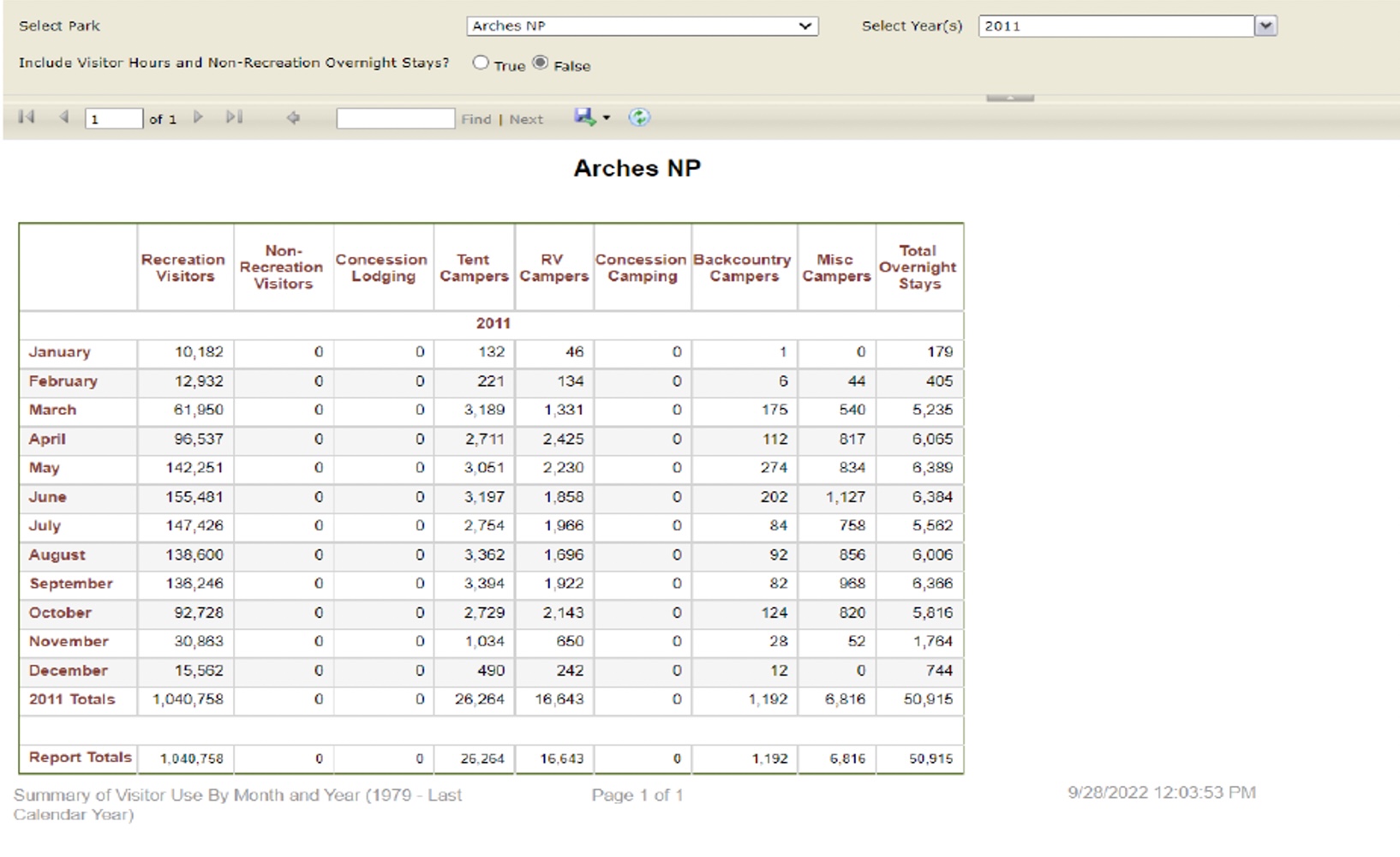
These Park Service data efforts conclude that visitation to the Arches National Park has doubled in the last 10 years, and this would be consistent with planning documents throughout the area. We have no reason to anticipate that visitation to the planning area has not increased at a similarly high level.  Rather than recognize the unexpected increase in visitation to the area, the Proposal never mentions this challenge or how it may impact the Proposal moving forward. This situation creates another foundational problem for the Proposal and the decision to prohibit new routes in the planning area, as we are unable to understand how quality trail experiences can be provided by a trail network that has been reduced by 40% of total mileage and usage has doubled.  This position is outlined in the Proposal as follows:

    1. Reducing network mileage within the TMA is not anticipated to result in a reduction in OHV use overall. Year-round OHV and non-motorized recreation use is expected to continue to increase slightly in and around the TMA regardless of the designations made as a result of this travel planning effort.
    1. Concentration of use as a result of OHV-Closed designations is not anticipated as an issue in this TMA. This conclusion was reached by the BLM IDT and applies for archaeology, wildlife, and other resources. Many of the routes proposed for OHV-Closed designations in the alternative networks are very lightly used, and therefore would not result in any appreciable concentration of use on the remaining open routes.[14]


Characterizing as “slightly increasing” a demonstrated two-fold increase in visitation to the area is unfounded.  It fails as the kind of proper analysis of this issue that NEPA requires in the Proposal.  NEPA requires high-quality information to support the decision-making process..  Commenting regarding this type of assumption and dearth of supporting data is impossible.  It renders a decision-making process that NEPA sought to avoid.

8(c).  Quality recreational access that is mandated in the RMP objectives will be denied by closures of 40%.

The Proposal should recognize and address the fact that significant restrictions to the planning area have resulted from recent planning efforts. These are highly relevant to the continued decline in the quality of motorized opportunities in the planning area.  They directly undermine any assertion that there is excess capacity in the motorized route system sufficient to absorb significant increases in area visitation.  There has been a significant increase in dissatisfaction of motorized users since the 2008 restrictions, and this has also forced many motorized users to other areas, such as Grand Junction FO and GMUG in Colorado, in order to obtain quality dispersed recreational experiences.

The RMP summarizes the significant scale of closures as part of the RMP process completed in 2008 is as follows:

Summary Table A OHV Categores[15]

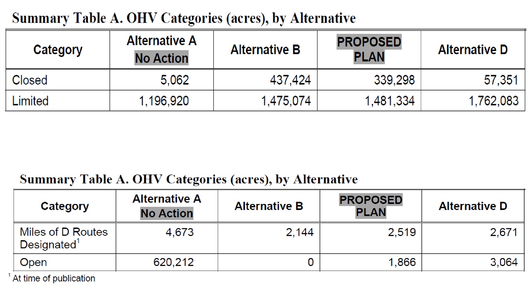
The impacts of these acres of closures are significant on the designated routes on the Moab FO which the FEIS generally summarized as follows:

Impacts on resources and user groups would be similar to Alternative B, except that the adverse impacts to motorized users would be reduced by limiting OHV travel to designated routes within 4,481,334 acres along with 3653 miles of Band D class routes.  123 miles of singletrack routes with 1866 acres open to cross country travel.[16]

The FEIS summarized the scope of these closures as follows:

This alternative has 339,298 acres closed to OHV use, which is approximately 67 times more than under Alternative A.[17]

An accurate summary of recreational opportunities on the Moab FO since 2008 would be there have been a 67 times expansion of acres closed in the area and more than 40% of routes have been closed.  Over the same time visitation to the area has at least doubled.  Given these factual conclusions, any assertion of a factual basis for the range of alternatives provided is unfounded and must be meaningfully addressed. Planning should address how this vision has impacted the ability to find recreational opportunities in the area and how the decision aligns with the Moab  RMP.

9(a).     NEPA mandates detailed statements of high quality information for all decisions made in the planning process.

Prior to addressing the Organizations’ more specific concerns on specific legal issues in the Proposal, the Organizations believe a brief review of NEPA requirements provided in regulation, various implementation guides and relevant court rulings is warranted to allow for comparison of analysis provided in the Proposal and the proper standard. The Organizations believe that the high levels of quality analysis that are required by these planning requirements frequently get lost in the planning process.  The lack of documenting the cause-and-effect relationship between management changes and impacts that will result, is a significant weakness in the Proposal.  This should be remedied in supplemental works to detail how impacts are related to changes and these subsequent planning efforts must be provided a full and complete public comment process.   Meaningfully analyzing this cause-and-effect relationship will result in significant changes to the preferred alternatives proposed in supplemental works.

At the landscape level of discussion, the NEPA regulations require any NEPA efforts to provide all information under the following standards:

… It shall provide full and fair discussion of significant environmental impacts and shall inform decision makers and the public of the reasonable alternatives which would avoid or minimize adverse impacts or enhance the quality of the human environment…. Statements shall be concise, clear, and to the point, and shall be supported by evidence that the agency has made the necessary environmental analyses….[18]

The regulations included the development of the Council of Environmental Quality, which expands upon the detailed statement theory for planning purposes as follows:

You must describe the proposed action and alternatives considered, if any (40 CFR 1508.9(b)) (see sections 6.5, Proposed Action and 6.6, Alternative Development). Illustrations and maps can be used to help describe the proposed action and alternatives.[19]

These regulations clearly state the need for the quality information being provided as part of this relationship as follows:

The CEQ regulations require NEPA documents to be “concise, clear, and to the point” (40 CFR 1500.2(b), 1502.4). Analyses must “focus on significant environmental issues and alternatives” and be useful to the decision-maker and the public (40 CFR 1500.1). Discussions of impacts are to be proportionate to their significance (40 CFR 1502.2(b)).[20]

The Proposal fails to account for the fact visitation has doubled and fails to provide any additional opportunities for the increased usage. Not only does the Proposal adopt a “no new trails” posture from the beginning, the Proposal provides for no expansion, even parking or toilets.  No discussion exists in the Proposal as to why the closures are needed or why the specific standard is necessary. This full and fair discussion of many issues has not been provided in the Proposal and associated documents. As more specifically addressed in later sections of the comments, the range of alternatives for multiple use access to the Proposal is unacceptable. Many of the assumptions that are provided in the Proposal simply have no factual basis as outlined previously.

9(b).  NEPA is designed and intended to stimulate public involvement and scrutiny.

The association of impacts from changes proposed to the management issue, is a critical component for developing public comments and involvement, because frequently members of the public do not have sufficient time, resources or understanding to make these connections.   These concerns are summarized in the NEPA regulations which clearly provide the reason for the need for high quality information to be provided in the NEPA process.   NEPA regulations provide as follows:

(b) NEPA procedures must insure that environmental information is available to public officials and citizens before decisions are made and before actions are taken. The information must be of high quality. Accurate scientific analysis, expert agency comments, and public scrutiny are essential to implementing NEPA.[21]

The Proposal does not provide a scientific or expert basis for many of the factual assumptions and positions therein, making them indefensible as they conflict with factual statements in prior NEPA matters.

NEPA analysis is supposed to stimulate public involvement and comment as part of federal planning actions.  This is woven throughout the NEPA regulations and the agency implementation documents. For example, the BLM Planning manual states:

The CEQ regulations also require that agencies “make diligent efforts to involve the public in preparing and implementing their NEPA procedures” (40 CFR 1506.6(a)).[22]

Yet high quality information on numerous issues is missing in the Proposal, thus forcing the Organizations to theoretically address numerous issues despite their asserted priority and importance. This lack of high quality information frustrates the Organizations’ ability to meaningfully and completely comment on a variety of issues.  Given that the Organizations have actively participated in countless NEPA analyses across the country, we struggle to understand the Proposal.  Surely the overall public is negatively affected by poor quality data and analysis in the Proposal.

The Proposal does not address any new information developed since the litigation and 2008 RMP.  The Proposal often asserts it is in compliance with the RMP but fails to support these assertions with analysis. The Proposal does not identify what the many issues are.  Many users say they feel frustrated in reviewing the plan.  They say that despite hours of review they cannot understand or explain what the management issue is in a particular area or why a particular route is being closed.  The Proposal’s failure to provide such information makes it hard for any member of the public to comment thereon. Hence the frequent and vigorous opposition to the Proposal voiced by a wide range of user groups.

The Proposal’s overlooking numerous foundational documents and guidelines has improperly misdirected the range of alternatives.  Given the foundational nature of the overlooked documents, the Proposal should be withdrawn to allow these foundational documents to be completely and accurately included in the Proposal inception.

9(c).      NEPA requires that issues be addressed with high quality information and analysis.

Numerous issues have not been sufficiently analyzed to satisfy NEPA planning requirements.    Much of the Proposal is disorganized and merely summarizes national planning guidance documents.  Mere summaries of planning regulations will not satisfy NEPA requirements for a detailed statement of high quality information regarding why a decision was made.

The general standards for NEPA analysis  of issues  are as follows:

Agencies shall focus on significant environmental issues and alternatives and shall reduce paperwork and the accumulation of extraneous background data. Statements shall be concise, clear, and to the point, and shall be supported by evidence that the agency has made the necessary environmental analyses. An environmental impact statement is more than a disclosure document. It shall be used by Federal officials in conjunction with other relevant material to plan actions and make decisions.[23]

The US Supreme Court has applied these standards to conclude as follows:

Agency action is arbitrary and capricious if an agency “has relied on factors which Congress has not intended it to consider, entirely failed to consider an important aspect of the problem, offered an explanation for its decision that runs counter to the evidence before the agency,” or the agency action “is so implausible that it could not be ascribed to a difference in view or the product of agency expertise.”[24]

 The Proposal does not meet the Supreme Court’s standard of review.  The Proposal disregards many factors Congress specifically identified for NEPA review and analysis, despite the availability of information necessary to do this.  The Proposal encompasses over 200 pages without any meaningful discussion of economic and travel management issues, both of which have received significant public input since scoping of the Proposal. Merely referencing the  BLM LUP handbook and asserting compliance therewith is facially unacceptable for any proposal.   NEPA requires a discussion of how the national standards were applied in the field office management decisions regarding specific areas, resource concerns and other field office specific management concerns.  That has not occurred for economic and travel related issues.

9(d).  NEPA requires a balance of uses and addressing of cumulative impacts.

As previously noted, NEPA requires a detailed statement of why a decision or alternative was chosen over other alternatives for resolving the challenge that is the basis of the NEPA analysis. The detailed statement is required on a wide range of topics, some of which often conflict.  But this does not absolve managers from making the analysis or forming the Proposal to avoid difficult factual questions or avoid discussions of the failures in the NEPA analysis.  One of NEPA’s fundamental goals is to:

promote efforts which will prevent or eliminate damage to the environment and biosphere and stimulate the health and welfare of man.[25]

As more completely addressed later in these comments, the Organizations have serious concerns that the welfare of man, more specifically the economic welfare of man, has not been properly addressed in the planning process. The Organizations believe the Proposal falls well short of stimulating the welfare of the residents that live in the local communities.

NEPA further requires that cumulative impacts be taken into account as follows:

Cumulative impacts can result from individually minor but collectively significant actions.[26]

The Organizations believe these cumulative impacts can take many forms, including not only addressing cumulative impacts to the environment but also addressing the cumulative impacts of the decisions made on a site-specific basis as part of the landscape level planning process. A cumulative impact that is simply never addressed in the Proposal is the fact that the visitation has doubled in the last decade to the planning area.  In 2008, the RMP closed approximately 40% of the motorized routes in the area.  This Proposal has alternatives that propose to close another 40% of the routes in the planning area, despite requirements in the RMP to provide quality recreational experiences on the Moab FO, and numerous site-specific development requirements as well. Cumulative impacts of exclusions in the analysis of specific factors must also be properly addressed in order to ensure that recreational opportunities are provided into the future as well.   This has not occurred.  There are numerous conflicts between the Proposal and Federal Law and regulation that is sought to be applied.  An example is seen in applying  the NTSA to prohibit protected uses of the Old Spanish Trail in favor of grazing interests that might be in the area.  The cumulative impacts of these decisions have not been reviewed, which has resulted in conclusions being reached in the planning process that are in conflict with research from federal, state, and user group research.

9(e).  Relevant Court rulings addressing NEPA standards directly apply to the NEPA regulations.

A brief summary of the standards that are applied by Courts reviewing agency NEPA analysis is relevant to this discussion, as the Courts have consistently directly applied the NEPA regulations to agency proposals.  Relevant court rulings have concluded:

an EIS serves two functions. First, it ensures that agencies take a hard look at the environmental effects of proposed projects. Second, it ensures that relevant information regarding proposed projects is available to members of the public so that they may play a role in the decision making process. Robertson, 490 U.S. at 349, 109 S.Ct. at 1845. For an EIS to serve these functions, it is essential that the EIS not be based on misleading economic assumptions.[27]

Other courts have summarized this standard as follows:

[E]nsure that federal agencies have sufficiently detailed information to decide whether to proceed with an action in light of potential environmental consequences, and [to] provide the public with information on the environmental impact of a proposed action and encourage public participation in the development of that information. [28]

As previously addressed, The Proposal has not stimulated public involvement, nor does the Proposal show that a hard look has not been performed.  The high levels of frustration expressed from the public in response to the release of the Proposal speaks to the quality of information provided and the ability of the public to comment on the information. Managers have not provided consistent information to the public regarding routes that are open and closed under each alternative. This portends serious difficulties for the agency in case of any court challenge.

10. The Proposal’s range of alternatives is unacceptably slanted, because many issues have not been sufficiently analyzed.

The lack of integration between expected recreational usage in the planning area and resources to be provided for that usage after implementation, is evidenced in the very limited range of alternatives that are provided in the Proposal.  The Proposal closes motorized routes to the public for recreational usage even under the most development intensive alternative.. As previously noted, the Proposal summarizes all resource management issues, such as air, water and soil health, as good to excellent currently, making a minimum closure under every alternative difficult to understand at best.

It is well established that NEPA regulations require planning to provide all information under the following standards:

… It shall provide full and fair discussion of significant environmental impacts and shall inform decision makers and the public of the reasonable alternatives which would avoid or minimize adverse impacts or enhance the quality of the human environment…. Statements shall be concise, clear, and to the point, and shall be supported by evidence that the agency has made the necessary environmental analyses….[29]

The regulations included the development of the Council of Environmental Quality, which expands upon the detailed statement theory for planning purposes:

You must describe the proposed action and alternatives considered, if any (40 CFR 1508.9(b)) (see sections 6.5, Proposed Action and 6.6, Alternative Development). Illustrations and maps can be used to help describe the proposed action and alternatives.[30]

These regulations clearly state the need for the quality information being provided as part of this relationship as follows:

The CEQ regulations require NEPA documents to be “concise, clear, and to the point” (40 CFR 1500.2(b), 1502.4). Analyses must “focus on significant environmental issues and alternatives” and be useful to the decision-maker and the public (40 CFR 1500.1). Discussions of impacts are to be proportionate to their significance (40 CFR 1502.2(b)).[31]

A reasonable range of alternatives has not been provided here. The Proposals failure to tie proposed changes to numerous basic assumptions, (such as the assertion that there is no need for more trail) has resulted in the public not being adequately informed about many viable options for management. These analysis flaws have resulted in a range of alternatives that bears no rational relationship to the planned recreational usage or local community benefits from that usage.  Ditto as to possible impacts to these communities from usage changes.

Providing an accurate and reasonable range of alternatives to the public as part of the NEPA process is a critical component of the NEPA process.  The rational decision-making process of NEPA is compromised when agencies consider only a limited range of alternatives to their proposed projects.[32]  When reviewing ranges of alternatives provided in a NEPA analysis, the Courts have consistently held:

The alternative section is ‘the heart of the environmental impact statement,40 C.F.R. 1502.14; hence, ‘[t]he existence of a viable but unexamined alternative renders an environmental impact statement inadequate.[33]

When determining if a NEPA effort has provided a satisfactory range of Alternatives, Courts have held the proper standard of comparison is to compare the purpose and intent of the NEPA effort to the Range of alternatives provided.  Other Courts have summarized this legal requirement as follows:

Irreparable damage may in the context of an action to enforce NEPA be implied from the failure by responsible authorities to evaluate fully the environmental impact of the proposed project, and consider alternative proposals before engaging in a project which constitutes major federal action.[34]

Given the numerous documents created by the Moab FO clearly providing a contrary direction for the management areas and guidelines that have been overlooked in the creation of the Proposal, the Organizations believe these failures have caused a range of alternatives to be presented that are significantly different from the range of alternatives that would have been presented if many priority concerns had been accurately addressed when the original vision for the Proposal was created. Given the foundational nature of these documents, the travel management portion of the plan should be withdrawn to allow for complete and accurate inclusion of these foundational documents in the creation of the Proposal.

11(a).   The economic analysis provided with the Proposal is incorrect on its face.

NEPA analysis also requires a meaningful review of the possible economic impacts to local communities from the Proposal. Prior to addressing more specific NEPA related concerns involved in the Proposal, a brief summary of the inherent complexity of any economic analysis is warranted.   Economic contribution calculations are often complex and involve a balance of numerous factors that directly impact the spending habits of those sought to be studied, and often involve far more analysis and discussion than planning for endangered species.  The basic complexity of any economic determinations and the size of the calculations to be made are summarized by the Western Governors’ Associations’ recreational economic contributions study as follows:

How is “economic impact” calculated? Many people might think of a consumer buying equipment – a tent, fishing pole, ATV, bicycle, boat, snowboard or rifle. However, the impact is much more complex than the manufacture and sale of gear and vehicles. Gas stations, restaurants, hotels, river guides and ski resorts benefit from outdoor recreation. In total, equipment and travel expenditures represent billions in direct sales that create jobs, income, tax revenues and other economic benefits.[35]

The complexity of the calculations undertaken for economic impact calculations is immediately evidenced by the number of pages required in most economic impact reports, as the explanation of the analysis process used to arrive at any final figure of any economic contribution analysis is often as valuable as the total economic contribution that is reached.

The basic mandate to include documented economic analysis early in the interdisciplinary team process for public lands planning is provided by the Federal Lands Planning and Management Act (“FLPMA”).  FLPMA specifies the various criteria that must be incorporated at specific times in the development of a land use plan as follows:

(c) In the development and revision of land use plans, the Secretary shall–

(2) use a systematic interdisciplinary approach to achieve integrated consideration of physical, biological, economic, and other sciences;[36]

The basic mandate of FLPMA regarding the critical need for documented economic analysis is more specifically and extensively addressed in Appendix D of the BLM’s Land Use Planning Handbook. Appendix D opens as follows:

“A. The Planning Process

To be effective, social scientific data and methods should be integrated into the entire planning process, from preparing the pre-plan to implementation and monitoring. The main social science activities for the various planning steps are outlined in Table D-1.

Table D-1. —Social science activities in land use planning

Planning steps

Social science activities
Steps 1 & 2—Identify Issues and Develop Planning Criteria ▪ Identify publics and strategies to reach them

▪ Identify social and economic issues

Identify social and economic planning criteria

Step 3—Inventory Data ▪ Identify inventory methods

Collect necessary social and economic data

Steps 4—Analyze Management Situation Conduct social and economic assessment, including existing conditions and trends and the impacts of continuing current management

Document assessment methods in an appendix or technical supplement

Step 5—Formulate Alternatives Identify social and economic opportunities and constraints to help formulate alternatives
Step 6—Estimate Effects of Alternatives ▪ Identify analysis methods

Analyze the social and economic effects of the alternatives

Document impact analysis methods in an appendix or technical supplement

▪ Assess mitigation opportunities to enhance alternatives’ positive effects and minimize their negative effects

Steps 7 & 8—Identify Preferred Alternative and Finalize Plan Identify potential social and economic factors to help select the preferred alternative
Step 9—Monitor and Evaluate Track social and economic indicators[37]

Tellingly, economic concerns are the only factor addressed by the BLM planning handbook for every step of the planning process. Documentation of economic forecasts and analysis methodology is required in two separate stages before release of draft alternatives. The required documentation of these concerns is exactly the information the Organizations are seeking to review but are unable to review. This lack of analysis of economic concerns has become even more apparent in the Organizations’ attempt to analyze economic concerns given the scope of inconsistency of the Proposal findings with the research works of any other federal, state, local, or user groups.

As a result of the facial inconsistencies between Proposal conclusions and all other available economic research, the Organizations sought to review the documentation on the process used to analyze economics, such as testing protocols, reviews of outside research materials, sampling of user groups and other factors involved in economic analysis. This documentation is specifically required to be developed in Step 4, 5, and 6 of the process identified in the Handbook.   This information is not provided or mentioned at all in the Proposal.

The Proposal fails to meaningfully address possible economic impacts of the Proposal, as basic foundational analysis points. Comparative spending profiles and estimates for visitation to the area are patently incorrect.  The Spending profile for recreational users provided by the Proposal is incorrect simply in that it asserts all recreational users spend similar amounts recreating in the area.  The Proposal identifies this cornerstone of analysis as follows:

Spending profiles for OHV visitors are similar to the overall spending profiles that the Moab BLM has developed for all recreation visitation to Moab BLM.[38]

Not a single study supports this assertion as far as the Organizations are aware.  All research known to us concludes that motorized users spend sometimes as much as 5 times more than other recreational users. Many recreational users rent equipment in Moab, these rental fees average at least $300 per unit per day, and many people rent multiple units. On top of that, taxes for rental vehicles in Moab are 15-19%, while taxes for rental non-motorized gear are under 9%.

A brief analysis of relevant court rulings on the quality and accuracy of economic analysis NEPA is helpful, as these standards are the benchmark for comparison.   The Courts have held:

an EIS serves two functions. First, it ensures that agencies take a hard look at the environmental effects of proposed projects. Second, it ensures that relevant information regarding proposed projects is available to members of the public so that they may play a role in the decision making process. Robertson, 490 U.S. at 349, 109 S.Ct. at 1845. For an EIS to serve these functions, it is essential that the EIS not be based on misleading economic assumptions.[39]

The Court then discussed the significance of economic analysis in planning as follows:

Misleading economic assumptions can defeat the first function of an EIS by impairing the agency’s consideration of the adverse environmental effects of a proposed project. SeeSouth La. Envtl. Council, Inc. v. Sand, 629 F.2d 1005, 1011-12 (5th Cir.1980). NEPA requires agencies to balance a project’s economic benefits against its adverse environmental effects. Calvert Cliffs’ Coordinating Comm. v. United States Atomic Energy Comm’n, 449 F.2d 1109, 1113 (D.C.Cir.1971). The use of inflated economic benefits in this balancing process may result in approval of a project that otherwise would not have been approved because of its adverse environmental effects. Similarly, misleading economic assumptions can also defeat the second function of an EIS by skewing the public’s evaluation of a project.[40]

The Court in the Hughes River decision invalidated an EIS based on an error in economic contribution calculations of approximately 32%. The current Proposal contains an error in economic calculations that is more than twice the 32% found sufficient in Hughes River to overturn the EIS in that matter.

11(b)(1). The US Department of Commerce has repeatedly and specifically concluded that recreational economics are driven by motorized spending.

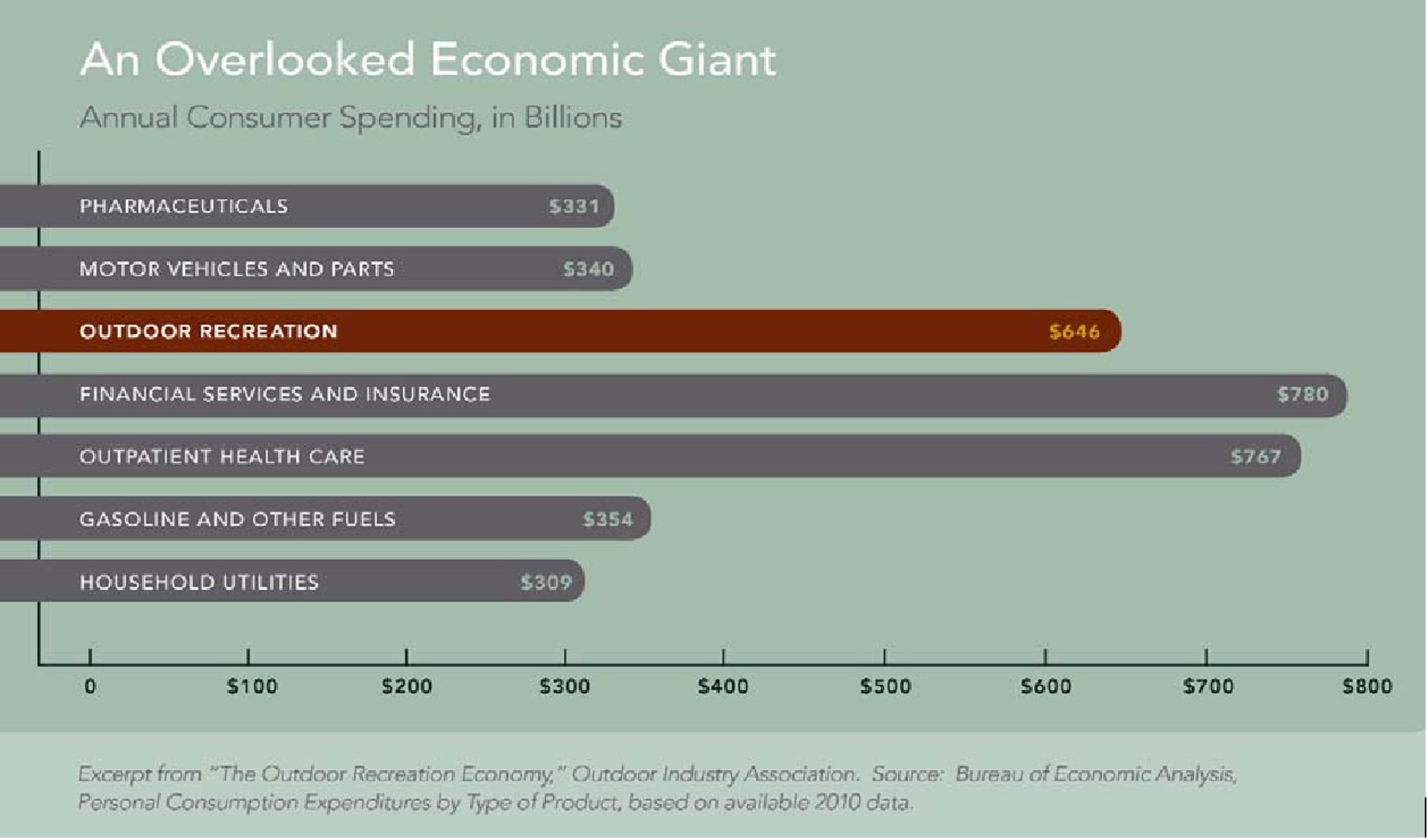
The availability of high-quality economic contribution data for recreational activities has recently been greatly expanded as the Department of Commerce has undertaken a 5-year state by state analysis of recreational spending that ended in 2021. Department of Commerce research commissioned by Secretary of Interior Sally Jewel to determine the value of outdoor recreation as part of the Gross Domestic Product was released. The research identified that outdoor recreation accounted for 2% of the GDP or more than $371 Billion in spending annually and that this value was steadily increasing from 2012 to 2016.  This research further concludes that motorized spending was the dominant portion of spending for recreational activity, and almost exceeded all other spending sources combined. This research provides the following breakdown of the total recreational spending: [41]

Gross Output for Selected Conventional Oudoor Recreation Activties 2016

The above chart from the Department of Commerce study indicates that motorized spending is occurring at a rate 6 times higher than all other recreational activities.  The Proposal’s patent conflict with this conclusion is highly problematic.

At the conclusion of the Department of Commerce research period, they provided spending conclusions for numerous different user groups for the 8-year period that they were able to research.  These conclusions are as follows:[42]


Table 1 Real Outdoor Recreation Value Added by Activity 2012


These motorized travel related economic conclusions show even more problems for the Proposal at the landscape level, as indications are that OHV and Motorized camping outspend all other possible recreational activities in the planning area, combined. OHV recreation alone comprised almost 3 times more spending than the hiking and tent camping category and almost 2 times the cycling category. This disparity only increased when RV camping was included in the analysis.

Given this clear and unequivocal demonstration of values to communities from motorized recreational uses, it is not reasonably arguable that the Proposal sufficiently analyzes these points.  These failures of analysis are even more immediate when compared to the high-quality peer-reviewed analysis of the economic benefits from motorized recreation.

11(b)(2).The Western Governors’ Association recently concluded that recreational spending is the driver for western economies.

Recreational usage of public lands is a significant portion of the Moab economy, especially in the smaller mountain communities that have already lost more traditional sources of revenue, such as timber, farming and mining. This is only more compounded by the fact that Moab has marketed itself as a global destination for recreation for decades. The critical nature of recreational economics to the western economies was recently highlighted in the Western Governors’ Association Get Out West report that specifically stated:

Spending on outdoor recreation is a vital part of the national and western economies.  It means jobs and incomes and can be the lifeblood of many rural communities in the West.  This snapshot helps highlight the value of this often-overlooked sector- one that is not otherwise measured as a traditional pillar of the US economy.[43]

Contrary to the huge value of recreational activity that has been identified by the Western Governors’ Association, recreational economics are only briefly addressed in a couple pages of the Proposal without analysis of what inputs were relied upon for development of these calculations. Given the limited analysis of economics, the Organizations are forced to analyze this issue on a very general level and believe that this analysis simply is not the detailed statement addressing high quality information that is needed for NEPA purposes.

The Western Governor’s Association provides a compelling summary of the value of the recreational activity for western states as follows:[44]


An Overlooked Economic Giant Annual Spending


11(b)(3). Proper integration of economic information in the planning process is an ongoing requirement in federal land management planning.

The proper integration of accurate economic information is often a weakness of the public lands planning process, which has resulted in the creation of many other longer-term problems when decisions reflecting an imbalance of multiple uses are implemented.  This concern was recently identified as a major planning issue that is not just limited to Utah.  The Western Governors’ Association released its Get Out West report in conjunction with its economic impact study of recreation on public lands in the Western United States which specifically identified that proper valuation is a significant management concern as follows:

Several managers stated that one of the biggest challenges they face is “the undervaluation of outdoor recreation” relative to other land uses.[45]

The Get Out West report from the Western Governors’ Association also highlighted how critical proper valuation of recreation is to the development of good management plans based on multiple use principals.  The Get Out West report specifically found:

Good planning not only results in better recreation opportunities, it also helps address and avoid major management challenges – such as limited funding, changing recreation types, user conflicts, and degradation of the assets. Managers with the most successfully managed recreation assets emphasized that they planned early and often. They assessed their opportunities and constraints, prioritized their assets, and defined visions.[46]

The Organizations believe our concerns regarding the Proposal and those expressed in the Western Governors’ Get Out West report virtually mirror each other. There can simply be no factual argument made that recreation has not been significantly undervalued in the Proposal and this has directed the range of alternatives provided for multiple use recreation on the Proposal.  The Proposal should examine potential direct and indirect impacts of each alternative on the undisputed value of multiple use outdoor motorized recreation, if only to reflect the analysis provided by Western Governors Association. NEPA requires comparing the values of each use.  That comparative analysis is missing in the Proposal.

11(c).US Forest Service National Visitor Use Monitoring spending profiles for recreation show a huge amount of diversity in spending profiles across user groups.

The Proposal asserts without basis that all recreational users have similar spending profiles..  This conclusion is incorrect as best available science clearly concludes that motorized users, who make up the heaviest impacted user group from the Proposal, are also the highest spending group of users who use business and economic opportunities provided in the Proposal area.

Contrary to the assertion in the Proposal, as part of the USFS efforts in the Visitor Use Monitoring efforts, the US Forest Service has provided hugely detailed analysis of the diversity of spending profiles of users as follows:[47]


Table 3 Visitor spending


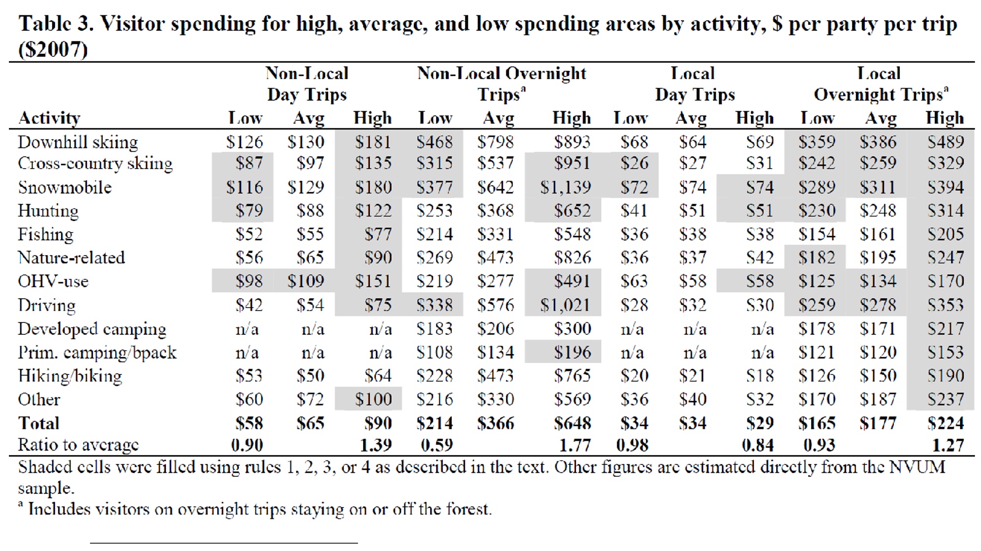
The USFS research further concludes that the type and nature of visitation can hugely impact the spending profiles of the recreational community:

Within activities and trip types, the greatest observed spending was for non-local downhill skiers on overnight trips ($893). The lowest observed spending was for locals hiking or biking on day trips ($18)[48]

Given that the USFS has clearly identified that motorized users consistently spend more than twice what similar users spend, the conclusions of the Proposal are problematic both factually and legally.  This simply must be corrected as this clearly identified the arbitrary nature of this assertion.

11(d).Non-Motorized recreation is not synonymous with entirely non-motorized area management.

The Organizations have provided detailed information regarding the significant imbalance of recreational spending when motorized vs. non-motorized activities are compared. Too often we have been told that non-motorized spending and non-motorized recreation are identical spending profiles and that non-motorized spends as much or more than motorized.  Highly credible sources such as BEA and WGA and others have concluded very differently on this issue.  Often the implications of this are lost if high quality economic analysis is not performed.  As a result, negative economic impacts to communities from proposed OHV travel restrictions, are grossly underestimated.

It is encouraging to see that some economic analysis has started to recognize the huge role that motorized access provides even in non-motorized recreational activities.  An example of this recognition is as follows:

“Quiet recreation” is recreation that does not involve significant motorized activity (such as motor-boating, snowmobiling, motorcycling, other off-highway-vehicle use, etc.)—aside from any transportation to and from the recreation sites. In this analysis, we estimate the number of “quiet recreation visits,” which are trips (of any length) to BLM lands managed by the CCFO in southwest Utah for the primary purpose of engaging in quiet recreation activities.[49]

The implications of this easily missed limitation on the study and travel planning are clear.  When areas are closed to motorized access, they are often closed to all recreational activity.   The implications of this are significant and often overlooked.  The Proposal’s planning area has an active drift boat/kayak/canoe community on the Green River. While these may be non-motorized pursuits, they are heavily impacted by motorized access as these units are brought to the area either on trailers or via car top carriers.  Removing motor vehicle access to portions of the river would result in people having to use other means to portage boats for access.  This would mean horse teams pulling the drift boat trailers or people carrying canoes and kayaks for long distances to access the river. Neither of these are occurring in the area and we have never heard of this type of access being chosen in any scale in other locations either. Functionally loss of motorized routes will impede these non-motorized activities significantly.  While this example may seem forced, it exhibits our concern. Closing 40% of the planning area to motorized access will impact motorized and non-motorized uses in the area and this impact will be substantial. This further undermines the conclusion that the closures will not negatively impact all aspects of the economy in the area.

Motorized access to portions of the river allows many users to shorten trips who do not have multiple days to float the entire section of river.  Cutting off such motorized access, entirely cuts out those potential visitations and the economic benefits they bring.  This is one of many examples of how closing 40% of the planning area to motorized access will significantly impact motorized and non-motorized uses in the area, and it undercuts the Proposal’s bare assertions that there will be no impacts from the proposed closures to economic benefits in the area.

11(e).The Proposal’s estimates of impacts From visitation changes are without basis.

The Proposal asserts that only 7,348 visitor days would be lost if 40% of routes were closed, but it provides no basis for this conclusion.[50]  The bare assertion that closing 40% of routes would reduce daily visitation by only 20 people, defies explanation.  No basis is given for this estimate.  Did this come from trail counters? Volunteers at trailheads, fly-overs, voluntary reporting? These are critical questions to the analysis and each of them provide their own unique set of questions for application of any results. Failures of basic information such as this are identified as a primary problem in the Western Governors’ Association report previously addressed in our comments concerning the camping proposal. Lack of visitation data plagued that proposal as well.  The Proposal’s apparent failure to attempt to capture accurate visitation data is problematic.

12(a). Routes designated under the National Trails System Act remain multiple use areas.

Almost every statutory provision that was applied in the Proposal was done so incorrectly. This includes but is not limited to the National Trails System Act, Wild and Scenic Rivers Act, and requirements of the application of best available science in the planning effort.

One leg of the Old Spanish Trail, which was designated as a National Historic Trail in 2002, is in the Proposal’s planning area.   While there was not significant conflict around these Congressionally designated routes at the time they were designated, conflicts have since arisen as some users have attempted to twist the nature of the designations for these routes. We have been active participants in the winter travel planning on the multiple forests in California and are intimately aware of the conflict around management of these areas in the winter travel planning process. We are intimately aware of the conflict that would result in summer planning with an application of similar management goals, and we would like to avoid this conflict.

See the 2020 US Supreme Court ruling clarifying the management relationship of lands that are managed under multiple use mandates by the USFS/BLM and also designated as a National Trail System Route, such as the Pacific Crest Trail and Old Spanish Trail. In US Forest Service vs. Cowpasture River Preservation Association[51], the US Supreme Court addressed the management relationship of the National Trails System Act and the Multiple Use mandate of the US Forest Service for the corridors around NTSA routes and the designated trail itself.  This is precedential and instructive for the BLM multiple use mandate as well.    The Supreme Court clearly stated the mere designation of any route under the National Trails System Act does not alter the multiple use mandate of the agencies managing this land. Economic impacts of excluding multiple uses from these areas was a major concern in these discussions.

The High Court also clearly found that the use of the right of way concept was not intended to alter the multiple use mandate but rather was a limited transfer of management authority between the Acts.  The Court clearly stated if Congress had the desire to remove the multiple use mandates from these routes, Congress clearly could have.  The Court compared the retained multiple use mandate of the National Trails System Act to the Congressional decisions to remove Wild and Scenic Rivers from the Multiple Use mandates for areas designated. The Court ruling provides significant protection for continued multiple use access to public lands and prohibits many of the proposed closures of the trail and adjacent areas to multiple usage recreation. Many of the organizations which have been seeking these exclusionary corridors in the winter travel plans on the Forest made these same arguments to the Supreme Court.  The Court ruled against applying these concepts, which are discussed in detail in the dissenting opinion that only garnered 2 votes, leaving little room for continued application or analysis of these positions in planning.

12(b). Congressional actions have identified motorized usage as a characteristic of an NTSA route and areas adjacent to them.

It is incorrect to say that motorized usage is inconsistent with the NTSA designation and degrades the quality of the route.  That assertion is factually as well as legally inaccurate as motorized usages are a characteristic of all NTSA routes that have been designated.  The use of motorized vehicles is specifically identified as characteristics of the NTSA and also protected by US Supreme Court decisions as these areas remain managed for multiple uses. The Proposal is taking an untenable position on this issue that is directly in conflict with the position argued by land managers in front of the Supreme Court a few years ago.

The following represents an example of the numerous erroneous statements of applicable law that plague the analysis of this issue.  The Proposal starts its outline of the negative impacts of motorized usages on other users’ vicarious experiences as follows:

OHV use on routes crossing or in proximity to the Old Spanish NHT increases the potential for damage to the trail’s historic integrity and increases the potential for disruption of travelers’ vicarious experiences along the trail.[52]

It is difficult to understand what a “vicarious experience” is on an NTSA route as motorized usages are actually protected, not mere perceived usages of the trail.  A concept like “vicarious experience” is difficult to define in relation to an NTSA route, especially a historic route.  The Organizations do not understand how a vicarious experience would be measured and improved as a tool of management as this type of measure would be comically subjective and removed from actual conditions on the ground.

The Proposal then continues discussion of the negative impacts of motorized usage conflicting with the trail’s purpose and integrity as follows:

Of the evaluated routes proximate to the Old Spanish NHT, Alternative B would designate 89.5 miles for OHV use, a 21% reduction from Alternative A. The effects noted above to the trail’s purpose and integrity would continue to occur on those routes designated OHV-Open or OHV-Limited. Overall, the potential for OHV-related impacts to the Old Spanish NHT under Alternative B would be the lowest of any alternative.[53]

Given that the understanding of the historic nature of the route is the purpose and integrity of the history of the area is the Congressionally identified purpose and need for the designation, the Organizations do not understand how motorized access to areas would be perceived as a barrier to this goal. Furthermore, the fact is that motorized usage is a Congressionally identified characteristic of the NTSA routes. The Proposal thus improperly elevates characteristics that are not protected in the NTSA designation, above usages that are protected by the NTSA.  The Proposal outlines this decision as follows:

Accumulating impacts to the Old Spanish NHT include loss of integrity from human activity on and around the trail as well as disruption of travelers’ experiences from human activity or livestock grazing in the trail’s vicinity.[54]

What this type of a statement even means in management analysis, defies understanding. Moreover, an analysis as livestock grazing is clearly not a characteristic of any NTSA route designation.  While grazing is often done in conjunction with a wide range of recreational activities without significant conflict, and may be an authorized multiple usage of areas adjacent to the Trail,  that still does not justify diminishing a protected characteristic of an NTSA route in favor of a usage that is not protected in the NTSA.

The Proposal over-analyzes, without cause, motorized usage on and around the Old Spanish trail, as motorized usage is a specific characteristic of NTSA designated routes identified by Congress.  In addition to the US Supreme Court clearly stating multiple use principles controlled NTSA routes and areas, Congress clarified the usages of NTSA designated routes by directly stating motorized usages in all forms were permitted by adding 16 USC 1246 (j).  This provision states:

Types of trail use allowed Potential trail uses allowed on designated components of the national trails system may include but are not limited to…the following: snowmobiling, …Vehicles which may be permitted on certain trails may include motorcycles, bicycles, four-wheel drive or all-terrain off-road vehicles.

These provisions are clear and prohibit the concept of a non-motorized corridor around any national trail system route simply due to the designation.  In several locations in the NTSA, proper recognition of multiple usage of a National Trail is specifically and clearly identified and motorized usages of the trail corridor were clearly identified as acceptable.  The 1983 amendments to the NTSA provides as follows:

j)Types of trail use allowed. Potential trail uses allowed on designated components of the national trails system may include, but are not limited to, the following: bicycling, cross-country skiing, day hiking, equestrian activities, jogging or similar fitness activities, trail biking, overnight and long-distance backpacking, snowmobiling, and surface water and underwater activities. Vehicles which may be permitted on certain trails may include, but need not be limited to, motorcycles, bicycles, four-wheel drive or all-terrain off-road vehicles. In addition, trail access for handicapped individuals may be provided. The provisions of this subsection shall not supersede any other provisions of this chapter or other Federal laws, or any State or local laws.[55]

Congressional actions have consistently identified the desire to provide a multiple use experience on any route that is designated under the National Trails System Act. The Proposal should avoid the conflict and fighting that has become far too common around NTSA designated routes. Legislative declarations on these designations specifically allow motorized usage on these routes as often these routes are collocated with major highways, or other existing motorized infrastructure.  In addition to the Legislative clarity, the US Supreme Court has also overwhelmingly stated that these routes and areas remain multiple use areas even after the Congressional designation of the route.

A National historic trail is also the least restrictive designation for a route under the NTSA, which is specifically identified in the Act as follows:

(3) National historic trails, established as provided in section 1244 of this title, which will be extended trails which follow as closely as possible and practicable the original trails or routes of travel of national historical significance. Designation of such trails or routes shall be continuous, but the established or developed trail, and the acquisition thereof, need not be continuous onsite. National historic trails shall have as their purpose the identification and protection of the historic route and its historic remnants and artifacts for public use and enjoyment. Only those selected land and water based components of an historic trail which are on federally owned lands and which meet the national historic trail criteria established in this chapter are included as Federal protection components of a national historic trail. The appropriate Secretary may certify other lands as protected segments of an historic trail upon application from State or local governmental agencies or private interests involved if such segments meet the national historic trail criteria established in this chapter and such criteria supplementary thereto as the appropriate Secretary may prescribe, and are administered by such agencies or interests without expense to the United States.[56]

Congress has clearly identified that the basis for designation and management of National historic Trails is the historic activities that have occurred on and around these routes.  The Organizations must question how any specific recreational experience could be derived from this designation. Congress has further clarified that recreational interests alone are insufficient to justify this type of designation as follows:

..the presence of recreation potential not related to historic appreciation is not sufficient justification for designation under this category.[57]

The goal is to educate the public. Given the explicit clarity of the National Trails System Act that motorized usage is a characteristic of these routes to be protected and preserved in areas where appropriate, the Organizations must question why any analysis of usage on the route and areas adjacent was even undertaken.

12(c). BLM guidance materials for the Old Spanish Trail specifically allow motorized usage.

Again, the fact that motorized usage is a characteristic of the NTSA designation, precludes the exclusion of the usage in the planning process, as is currently proposed in the Plan.  The usage of motorized vehicles on and around the Old Spanish Trail is also specifically addressed in the Guidance materials that have been developed by BLM and US Park Service. The multiple use nature of the Old Spanish Trail is specifically addressed in the BLM final Guidance material for management of the Old Spanish Trail as follows:

Motorized vehicle recreation (two-wheel and single-track, as well as four-wheel) is widely enjoyed in the region crossed by the trail. Where appropriate, trail administrators will promote and support motorized vehicle use only on designated travel routes on public lands or on segments of routes on nonfederal lands that are designed, managed, and maintained for such uses. Motorized vehicle use on historic route alignments will be discouraged.[58]

This internal guidance document further specifically recognizes the application of section 7(j) of the NTSA as follows:

Further, Section 7(j) of the National Trails System Act states that potential trail uses may “include, but are not limited to, the following: bicycling, cross-country skiing, day hiking, equestrian activities, jogging or similar fitness activities, trail biking, overnight and long-distance backpacking, snowmobiling, and surface water and underwater activities. Vehicles that may be permitted on certain trails may include, but need not be limited to, motorcycles, bicycles, and four-wheel-drive or all-terrain off-road vehicles. In addition, trail access for handicapped individuals may be provided. The provisions of this subsection shall not supersede any other provisions of this Act or other federal laws, or any state or local laws.[59]

As motorized usage is a characteristic of any NTSA routes, the Proposal’s large amount of analysis of possible impacts to certain trail usages that could occur from multiple uses occurring in these areas, is inexplicable. The Organizations oppose the analysis of usages based on the corridor concept, as characteristics of the trail are to be protected and preserved according to multiple use mandates based on recent Supreme Court rulings. While Alternative D may be the least objectionable in this regard, the Organizations object to any exclusionary corridors for motorized usage in the Proposal as this concept conflicts with Statute, relevant case law from the US Supreme Court, and BLM guidance on the issue.

12(d). A characteristic of any area cannot reasonably be seen as a value that negatively impacts the area.

The Organizations are very concerned that NTSA discussions have become overly narrow in scope as a result of exceptionally poor implementation efforts and have become far too focused on recreational uses of these areas. There are hundreds of multiple uses of areas in and around an NTSA route that are not identified as a characteristic of the NTSA.  These would include energy development facilities, energy transmission facilities, grazing, mineral extraction, timber to name a few.  Are these uses that might be restricted in the vicinity of an NTSA route?  Possibly as these uses are not characteristics of the area or Congressional designation. The Organizations could clearly see the development of an extractive surface mine for minerals negatively impacting almost every characteristic sought to be preserved and protected by the NTSA.  Motorized usage of any NTSA route should not be restricted based merely on the designation of the route under the NTSA, as motorized usage is a Congressionally and Supreme Court protected characteristic of the designation.  Given this conflict the Organizations are unable to support even Alternative D as a result of the direct conflict of the alternative and relevant statutes and interpretations.

13. The Proposal makes no effort to correct its potential pre-decisional impacts on the camping analysis that is ongoing.

The Proposal threatens to have pre-decisional impacts on concurrent efforts to address dispersed camping in the planning area. The concern is not around the objection process occurring before the final decision is made, but rather with the more general definition of pre-decisional where decisions are made before any analysis is provided. This would reverse the entire NEPA process on both efforts as NEPA would not be used to guide the decisions to be made but rather would be justifying decisions that have already been made. The CFR specifically addresses this situation as follows:

An agency should commence preparation of an environmental impact statement as close as practicable to the time the agency is developing or receives a proposal so that preparation can be completed in time for the final statement to be included in any recommendation or report on the proposal. The statement shall be prepared early enough so that it can serve as an important practical contribution to the decision-making process and will not be used to rationalize or justify decisions already made[60]

The pre-decisional nature of this situation calls into question the accuracy of foundational assumptions and assertions in this Proposal and the Camping Proposal.[61] What the office has created by pursuing independent planning efforts, which provide no guidance whatsoever on how each of the decision making processes will be integrated with the other, is a process where both dispersed camping can be closed as there is no access to the route and routes can be closed as there is no legal access to the dispersed site. Under this model, there is unduly broad discretion to close routes and no requirements to discuss or justify any of this decision-making process via NEPA.

The scale of this problem cannot be overstated as 7 of the first 10 routes listed in the route inventory in this Proposal are involving camping access. A sampling of additional route-specific analysis indicates a continued strong relationship of these factors to each other in the entire process of this effort. The Organizations are also very concerned regarding the pre-decisional nature of any camping-based decisions as these decisions would also remove the need for the route that was accessing the area without meaningful analysis of other resources that might be accessed by that route. In the camping plan these routes are identified as “damage points” in the analysis.[62] Access issues for camping in the area must be addressed as this is a critical component of the recreational experience the areas are required to provide pursuant to the RMP.

14. Best available science requirements are not supported by references to generalized surveys of research.

The Organizations strongly dispute claims of impacts to wildlife resulting from OHV usage in the Proposal.    The problematic nature of surveys for specific species is compounded by the fact that several of the species do not occur in the planning area. A survey is merely a survey of possible resources for any management issue; it is not the best available science that management should be based upon.  This is exemplified by the following discussion provided in the Proposal.  The Proposal’s prejudice is shown by its reference to the Ouren survey.

Direct mortality can result from accidental collisions with OHVs, intentional and illegal poaching of special status wildlife, or the inadvertent destruction of eggs, nests, and burrows by unwitting individuals. Injury can result from animal- vehicle collisions or animal exposure to OHV effects such as the inner-ear bleeding found to occur in small mammals exposed to OHV-generated noise (Ouren et al. 2007). Additionally, roadside use, whether by foot, camping, roadside parking, passing, staging, or other means, can lead to the alteration of animal behavior or alteration or destruction of foraging, burrowing, or nesting habitats.[63]

Again, a survey is not authoritative best science but rather is a survey of research, nothing more.  When this assertion is pursued deeper, the Ouren Survey cited 11 times in the Proposal references back to a 1980 Survey conducted by Andrews.  The 1980 Andrews survey is prefaced on almost every website where it’s found with the following warning: [64].

Historic Archive Document

Given this warning, it is questionable how the 1980 Andrews survey could be relevant enough to gain mention in 2017.  This concern continues to expand as it is now 2022.  Given this clear statement that the document is not best available science, the Proposal should not rely on this document in any manner for any reason.   Generally speaking, the Proposal’s use of surveys referencing earlier surveys compound the lack of confidence in the Proposal itself.  The Proposal should not rest on mere editorial content, but rather on science, best available science.   Clearly this survey is not that.

Concerns over lack of best available science are buttressed by the fact that the documentation the Proposal does cite actually does not support the Proposal. The 1980 survey relied upon by Ouren  outlines this issue as follows:

Dr. Bayard Brattstrom and Michael Bondello of California State University, Fullerton, have recently undertaken studies on the effects of vehicle noise on three species of vertebrates….. Desert kangaroo rats are deafened by 500 seconds of intermittent dune buggy sounds and then can be approached and eaten by the snakes. The rats show recovery of hearing sensitivity after 21 days.[65]

In other words, the 1980 itself work clearly states these findings are preliminary.  The work was never peer reviewed or published as far as we can determine.  So not only is the Ouren survey inappropriate to rely on as best available science, it is also inaccurate on this issue.

15. The Proposal should recognize that the State of Utah is increasing its support of trail work, education, and law enforcement in the planning area.

The motorized community is the only community that can bring significant resources to the Moab FO to assist with management and maintenance of routes for the benefit of all users. The Utah OHV Program has made significant strides in the development of their partner program to provide funding for OHV management. This program currently provides several million dollars for summer maintenance and this would be a program we would expect to significantly grow over the life of the RMP. This significant direct funding probably makes the motorized trail network the most sustainable in the planning area and, to keep pace with increasing use,  the new DNR Division of Outdoor Recreation is hiring staff to do more trail work and enforcement patrols specifically in southeast Utah. Further, Utah’s new Off-Road Vehicle Safety Education Act will require (a) all OHV operators to complete an education course, (b) all ATVs to display license plates for easier identification, and (c) vehicle operators who are convicted of going off-trail to repair their damage through community service. With these additional resources, the BLM will be able to effectively implement alternative A and resolve any issues with the status quo.

These types of contributions were recently recognized by the USFS planners as part of the Sustainable Trails effort as follows:

The engagement and efforts of motorized groups have improved the condition of trails across National Forest System lands and we look forward to continued engagement with the motorized community as part of the Trail Challenge…. During phase one, I welcome collaboration to adequately track, monitor, and acknowledge accomplishments by the motorized community while identifying lessons learned to incorporate into future phases of the Trail Challenge.[66]

This type of a statement to a partner agency to the USFS should be significant. While many interests are struggling mightily to provide a single maintenance crew, the Utah OHV Program has made huge strides in the last several years to create a maintenance program for summer recreational opportunities.[67] This is a model of collaboration moving forward, and the Proposal should avoid any unintended negative impacts to this collaboration.  Over the life of the Proposal this partnership will grow into a strong and important funding partner for the Moab FO.

In addition to the direct funding of BLM management, the sustainability of the motorized community is significantly buttressed by the fact that every route available for usage by the motorized community has been subjected to significant scrutiny under the travel management Executive Orders issued by President Nixon in 1972. No other recreational activity on public lands has been subjected to this level of scrutiny and analysis. The Organizations believe the strategic implications of providing areas in southern Utah that provide that “carrot” to the users who have worked so hard to date to create a sustainable trails network that aligns with the BLM lands. The value of this type of message should not be overlooked. We believe this is a model of collaboration moving forward, and the Proposal should avoid any unintended negative impacts to this collaboration, and that over the life of the Proposal this partnership will grow into a hugely strong and important funding partner for the Moab FO.

16(a). The Proposal should temper the swings of paradoxical opinions.

The Moab community has marketed itself as a global destination for all forms of recreation for decades and this marketing has been successful as Moab has become a global destination for recreational activity in many forms. This was in stark contrast to what Moab used to provide for recreation, where visitation was much smaller scale and advertising was passive to non-existent. Moab was a mining community that recreated on the weekends. Mining then largely stopped, and recreation was targeted to replace the lost revenues from mining. While this advertising has been successful, the community has also been divided between those that support this recreational economic benefit and those that are opposed to it. This “close the door behind me” type mentality has become far too common in areas where Americans are moving to as a result of the easy access to recreational activities and public lands more generally.  Moab has become the focal point for this type of discussion. Too frequently this mentality strangely correlates with large areas of public lands that these communities are often synonymous with.

While this internal discussion about what Moab wants to be as a community remains ongoing,  Moab continues to advertise itself as a recreational destination across the world. Below are a few samples of current advertising efforts from Moab inviting the public to visit Moab and experience the public lands.

Moab Daily Flights – YouTube

Moab advertisements


Many small communities have rapidly developed due to their slower lifestyles and proximity to large areas of public land, and this has often created conflict as many of the newer residents that have moved to these areas do not understand public lands and see these areas as an opportunity to build private recreational opportunities. While this is a situation that is becoming more common, Moab has continued to advertise itself as a recreational destination. This is in stark contrast to many other recently developed recreational destinations, such as Lake Tahoe in California, Aspen Mountain in Colorado, and Jackson Hole in Wyoming where they are advancing exceptionally limited targeting of recreational visitation.  This has resulted in an unusual and somewhat offensive situation where the Moab community is inviting the public to come and experience the area.  Once the public comes, they are blamed for visiting the area by a segment of the community. This is not okay, and also puts public-lands managers in a very difficult position.

16(b).  Best available science concludes closures often make conflict worse instead of better.

The Organizations believe that analysis of how best available science supports the management decisions and direction of any proposal constitutes a critical part of the planning process, especially when addressing perceived user conflicts.  This analysis will allow the public to understand the basis of alleged user conflicts and why travel management has been chosen to remedy the concern.   Relevant social science has clearly found this analysis to be a critical tool in determining the proper methodology for managing and truly resolving user conflicts.

When socially based user conflict is properly addressed in the Proposal, the need for travel management closures will be significantly reduced. Researchers have specifically identified that properly determining the basis for or type of user conflict is critical to determining the proper method for managing this conflict.  Scientific analysis defines the division of conflicts as follows:

For interpersonal conflict to occur, the physical presence or behavior of an individual or a group of recreationists must interfere with the goals of another individual or group….Social values conflict, on the other hand, can occur between groups who do not share the same norms (Ruddell&Gramann, 1994) and/or values (Saremba& Gill, 1991), independent of the physical presence or actual contact between the groups……When the conflict stems from interpersonal conflict, zoning incompatible users into different locations of the resource is an effective strategy.  When the source of conflict is differences in values, however, zoning is not likely to be very effective. In the Mt. Evans study (Vaske et al., 1995), for example, physically separating hunters from nonhunters did not resolve the conflict in social values expressed by the nonhunting group. Just knowing that people hunt in the area resulted in the perception of conflict. For these types of situations, efforts designed to educate and inform the different visiting publics about the reasons underlying management actions may be more effective in reducing conflict.

Other researchers have distinguished types of user conflicts based on a goal interference distinction, described as follows:

The travel management planning process did not directly assess the prevalence of on-site conflict between non-motorized groups accessing and using the yurts and adjacent motorized users…..The common definition of recreation conflict for an individual assumes that people recreate in order to achieve certain goals, and defines conflict as “goal interference attributed to another’s behavior” (Jacob & Schreyer, 1980, p. 369). Therefore, conflict as goal interference is not an objective state, but is an individual’s appraisal of past and future social contacts that influences either direct or indirect conflict. It is important to note that the absence of recreational goal attainment alone is insufficient to denote the presence of conflict. The perceived source of this goal interference must be identified as other individuals.

It is significant to note that Mr. Norling’s study, cited above, was specifically created to determine why winter travel management closures had not resolved user conflicts for winter users of a group of yurts on the Wasatch-Cache National forest. As noted in Mr. Norling’s study, the travel management decisions addressing conflict in the areas surrounding the yurts failed to distinguish why the conflict was occurring, and this failure prevented the land managers from effectively resolving the conflict.

The Organizations believe that understanding why the travel management plan was unable to resolve socially based user conflicts on the Wasatch-Cache National Forest is critical in the Labyrinth Rims/Gemini Bridges planning area.  Properly understanding the issue to be resolved will ensure that the same errors that occurred on the Wasatch-Cache are not implemented again to address problems they simply cannot resolve.  The Organizations believe that the Moab FO must learn from this failure and move forward with effective management rather than fall victim to the same mistakes again.

16(c). Court decisions on user conflicts have reviewed management decisions closely.

Courts have reviewed generalized claims of user conflicts as the basis to alter existing site-specific strategies for use and expansion of access in areas with concerns around user conflicts with some detail.  This is exemplified by the 9th Circuit decision in the matter of Wild Wilderness v. Allen.[68]  In this case, the USFS Deschutes NF had embarked on a long-term plan to reduce the user conflicts occurring on the Forest between motorized and non-motorized users.

The USFS plan in the Deschutes RMP looks surprisingly similar to the provisions in the Proposal.

Part of the Deschutes Forest plan was to expand motorized parking and access in several areas.  In the site specific NEPA for the expansion of these areas, non-motorized users challenged the expansion of access for motorized usage asserting user conflicts would be increased. The USFS was able to demonstrate the success of existing planning in reducing user conflicts and that expanding motorized access would not reverse this trend. In the 24-page decision that confirmed the USFS decision, the 9th Circuit looked at assertions of conflict with a surprising level of detail. We believe this decision is highly relevant to the direction of the Proposal and details how the BLM will need to document its management direction and any alteration of the management direction should there be a desire to do so.  Such a change would need to be detailed with a high level of specificity.

17. President Biden’s executive Orders requiring an expansion of recreational opportunities should be addressed in the Proposal.

There have been numerous actions by Congress and the Executive Branch directly targeting southern Utah with numerous landscape-level planning requirements. Often these decisions are not accurately summarized or entirely overlooked by some portions of the public in the planning process.  The recent issuance of Executive Order # 14008 by President Biden on January 27, 2021 would be an example of a decision that is often only partially summarized in most materials we are seeing submitted in comment processes for federal land planning, as the “30 by 30” concept is memorialized in this Order. It is our position that the “30 by 30” concept was long ago satisfied in the planning area given the large expansions of either Congressionally designated wilderness, national parks and monuments, and national conservation areas along with administrative designations in the region. There can be no argument that the national parks, wilderness area, and WSAs that completely surround the planning area are not sufficient to balance the planning area as they combine to be many times larger than the planning area.

In direct contrast to the summaries of EO 14008 we are seeing, this Order had provisions protecting lands generally but also had specific goals of improving access to public lands. This has been overlooked in most summaries, but the Organizations submit these requirements are critical to bringing balance to public lands.  §214 of EO 14008 clearly mandates improved recreational access to public lands through management as follows:

It is the policy of my Administration to put a new generation of Americans to work conserving our public lands and waters. The Federal Government must protect America’s natural treasures, increase reforestation, improve access to recreation, and increase resilience to wildfires and storms, while creating well-paying union jobs for more Americans, including more opportunities for women and people of color in occupations where they are underrepresented.

The clear and concise mandate of the EO to improve recreational access to public lands is again repeated in §215 of the EO as follows:

The initiative shall aim to conserve and restore public lands and waters, bolster community resilience, increase reforestation, increase carbon sequestration in the agricultural sector, protect biodiversity, improve access to recreation, and address the changing climate.

217 of EO 14008 also clearly requires improvement of economic contributions from recreation on public lands as follows:

Plugging leaks in oil and gas wells and reclaiming abandoned mine land can create well-paying union jobs in coal, oil, and gas communities while restoring natural assets, revitalizing recreation economies, and curbing methane emissions.

Significant concern has been raised around the “30 by 30” concept that was also memorialized in EO 14008. While the EO does not define what “protected” means, the EO also provided clear and extensive guidance on other values to be balanced with. From our perspective, the fact that large tracts of land in the planning area are Congressionally designated or managed pursuant to Executive Order far exceeds any goals for the EO. While there is overlap between these categories that precludes simply adding these classifications together, this also does not alter the fact the planning area has achieved these goals of 30% of acreages being protected as these protected areas both surround the planning area and dwarf it.

18. Alternatives for Wild and Scenic River areas could include roads and trails.

The Organizations are aware that the Green River was partially designated Wild River and partially designated as a Scenic River in 2019 by the Dingell Act. Pursuant to the Scenic designation, minimal road access was allowed to the corridor around the area. Even with a Wild designation, trail access to these areas is allowed. This access level to these areas is clearly and specifically identified in the act as follows:

(1) Wild river areas – Those rivers or sections of rivers that are free of impoundments and generally inaccessible except by trail, with watersheds or shorelines essentially primitive and waters unpolluted. These represent vestiges of primitive America.

(2) Scenic river areas – Those rivers or sections of rivers that are free of impoundments, with shorelines or watersheds still largely primitive and shorelines largely undeveloped, but accessible in places by roads.[69]

It should be noted that the varying characteristics and natures of these designations were the basis of extensive designation around the passage of the WSR act.  While roads and trails are a defining characteristic of these designations, the Proposal seeks to analyze these defining characteristics of the river compared to a no change from purely primitive areas or something akin to a Wilderness Corridor around the River.  Given that the Wilderness Act was passed into law in 1964 and the Wild and Scenic River Act was passed in 1968, there can be a very strong inference that Congress clearly intended that some level of alteration of the landscape is permitted in areas designated as Scenic.  This inference becomes even stronger when the sponsor of both the Wilderness Act and Wild and Scenic River act is recognized as the same person, Senator Frank Church from Idaho.  Even Wild Rivers may be accessed by trails of all forms so again clearly some level of impact is acceptable especially as these are defining characteristics of different designations of River Stretches.  Even a Wild River may be accessed by motorized trails and exemplifies the wide range of recreational opportunities that Congress sought to provide with any level of WSR designation.

The clearly stated desire of Congress to create a designation that was not Wilderness but protected certain values in the River System is specifically addressed in the legislative history of the Wild and Scenic River Act as follows:

The bill has been referred to as an extension or corollary of the Wilderness Act, but its provisions are not nearly as restrictive. A national wild or scenic river area will be administered for its esthetic, scenic, historic, fish and wildlife, archeologic, scientific, and recreational features, based on the special attributes of the area. However, it will not prohibit the construction of roads or bridges, timber harvesting and livestock grazing, and other uses that do not substantially interfere with public use and enjoyment of these values. Mining will be allowed to continue, although claims located after the effective date of the act may be subject to regulation to conform to the system, particularly to prevent pollution.[70]

Given that the Wilderness Act and Wild and Scenic Rivers Act were both written by Senator Frank Church of Idaho, we submit the clearly stated Congressional intent of the Legislation that a Wild and Scenic River designation is significantly less restrictive than a Wilderness designation is highly relevant to our concerns on the Proposal. Many of the alternatives provided are in direct conflict with the clearly defined management boundaries of the Wild and Scenic River Act. The Organizations submit that closing trails in the Scenic River corridor of Labyrinth Canyon is no more appropriate or legal than building a motorized trail in a Wilderness Area.  Congress has spoken on these issues and these decisions are outside the scope of land manager authority to alter, regardless of the public pressure to do so.

It is from this position of the level of motorized access being a defining characteristic of the various types of levels for Congressional designations that we must object to the Proposal seeing all impacts as negative to the designation. The Proposal proposes the following analysis of routes in the Scenic River corridor:[71]

Figure 3.14 Miles of Evaluated Routes in Green River Scenic WSR Corridor

This chart specifically exemplifies how altered the range of alternatives is for the entire Proposal, as Alternative B actually manages the corridor to the exclusion of roads and trails, despite these areas being a defining characteristic of the designation. No explanation is provided to allow the public to meaningfully understand how these alternatives were identified and developed. This is problematic as there are no paved roads in the Scenic River corridor but rather primitive (Class D) roads and one graded (Class B) road, which provide a FAR more limited recreational opportunity than a paved road. Not only is this arbitrary under NEPA, this is in direct conflict with the clearly stated desire of Congress around the desired experience provided in a Scenic River corridor.

The WSR management proposal creates further concern as we are unable to identify any change in condition type analysis for NEPA purposes regarding why current management of these areas has been found to be insufficient to protect resources in the area.  As we have identified previously, planning in this area was completed in 2008 and the Proposal clearly identifies that there are no resource impacts from recreational trails in the area.   The Organizations are very concerned that the finding that there are no resource impacts in the area is made without limitation. This means the BLM has found that existing access levels are consistent with the WSR management goals and objectives.  In this situation, we must ask why no alternative provided carries forward existing management in these areas. At best Alternative C provides for a 20% reduction in access to these areas without any analysis at all.  This is a problem.

This failure to even address changes in usage gives rise to a situation exhibiting the general poor analysis of the Proposal in general.  Clearly the analysis provided in the range of alternatives has been based on conclusions that are inconsistent with other areas of the analysis, mainly that there is too much visitation to these areas.  This would immediately conflict with the range of alternatives for the entire Proposal that existing resources are sufficient to continue to provide opportunities.  This type of a conclusion, that existing resources are insufficient to support vitiation, would warrant discussion of how better to address increased visitation to these areas.  That has not been provided and is a very good example of the circular logic that plagues the Proposal and its decision that more routes must be closed in this area.

Are there characteristics or uses that would be incompatible with any level of WSR designation?  That answer is, of course, yes, and could be exemplified by mine development and activity, dam development, energy transmission lines, high intensity grazing or other usages incompatible with recreation to name a few, but none of these inconsistent usages are within the scope of the Proposal. This concern over inconsistent usages along a Scenic River designation are exemplified by the fact Congress provided for a 2-mile-wide corridor around a WSR designation to prohibit mineral extraction.[72]  Again we are unable to understand how a defining characteristic of these designations could subsequently be removed based on the threat that these defining characteristics are thought to have on these areas.

Finally the WSR management proposal should account for the fact that motorboat use of Labyrinth Canyon has a long history and a long future ahead. The “Friendship Cruise” is a motorboat event that occurred every year for decades, and motorboats continue to navigate Labyrinth Canyon for recreational and administrative purposes. This activity will continue as there’s no interest in prohibiting motorboats by the State of Utah, which manages the Green River and other navigable waterways.

19. The Proposal should resolve the systemic issues inherent in its wildlife analysis, that were identified by the Organizations’ expert review.

Please refer to the attached Exhibit “10” entitled “Labyrinth Rims TMP Wildlife Report 10-21-2022,” which is incorporated into these comments to be analyzed by the BLM, not merely as a reference document. Broadly the wildlife analysis demonstrates that the best available science justifies few if any of the closures proposed in alternatives B or C.

20. The Proposal should incorporate the knowledge of local OHV groups.

OHV groups based in Moab, such as Moab Friends For Wheelin’, Red Rock 4-Wheelers, and Ride with Respect, have been faithful partners with the Moab FO for decades. In addition to educating visitors, each of them has dedicated several-thousand hours of service work to implement and refine the current travel plan in this planning area alone. Their perspectives come from working closely with fellow motorized-trail enthusiasts and land managers in the planning area, so their comments warrant additional attention.

Please see Exhibit “11” entitled “Labyrinth Rims TMP Letters from Local OHV Groups 10-4-2022,” which is incorporated into these comments to be analyzed by the BLM, not merely as a reference document. Note that some of these comments were sent to the Grand County Commission from its Motorized Trails Committee, which we do not represent, but we support the comments and are addressing them now to the BLM as they directly pertain to the Proposal.

Also see Exhibit “12” entitled “Labyrinth Rims TMP route-specific letter from RwR,” which is incorporated into these comments to be analyzed by the BLM, not merely as a reference document. The Organizations support this letter, which highlights the value of some key routes, and suggests mitigation measures as alternatives to route closure.

Note that the Exhibit “12” only makes route-specific comments that weren’t already covered in the October 6th letter submitted by Colorado Offroad Trail Defenders (COTD). Please regard the COTD letter as incorporated into these comments to be analyzed by the BLM. In 527 pages, the COTD letter painstakingly documented observations that are accurate and relevant to reach conclusions that are reasonable and thus supported by the Organizations.

21. The Proposal should honor input from the county that developed legislation which established area designations.

Emery County, which developed the public-lands bill that was packaged into the Dingell Act, did not intend for the Scenic River designation to access on routes currently designated open for motorized use.  Further Emery County did not intend for wilderness designations to be “mirrored” in any adjoining counties.  This intention of Emery County was upheld and respected in the legislation itself.  The bill contains an important provision to the effect that the existence of any wilderness or other special designation in or bordering Emery County shall not be construed to affect land management values, policies, and programs in adjoining counties.  Consider the following comments that Emery County Public Lands Administrator, Jim Jennings, submitted to the BLM on 10/5/2022:

I am writing in regards to the “Labyrinth Rims Gemini Bridges Travel Management” comment period and want to share some information that Commissioner Kent Wilson of Emery County and I have discussed and agreed upon to share.  The Dingell act that was passed in 2019 affected the Emery County side of the Green River that included thousands of acres of Wilderness Land.  The intent of the Dingell act and the decisions that were made during that process, was not to influence any other Counties land management decisions.  Emery County does not have the power or the desire to influence other Counties land management decisions.  The Emery County side of the river is much different than the West side or Grand County side of the river.  The routes to the river access were very few in number in Emery County and were cherry stemmed as part of the Dingell act.  It is important for all user groups to be able to have access to the river, not just for those floating the river.  There are many historic motorized routes that should remain open to allow access for all types of user groups.  The implementation of the “scenic” section of the river in the Dingell act implies that it is “Scenic”  It was not designated as “Wild”.

We recognize the importance of the precious water ways and sources and the beauty that it provides as part of the outdoor experience.  We hope that as you move forward and think of the wildlife, soils, access to State of Utah lands, Off Highway Vehicle recreation opportunities, non motorized recreation activities and all other parts of this decision, that you please put high priority into keeping routes open for the disabled and elderly and those families who are trying to take young children out to explore and learn about the outdoors and the beauty of this amazing area.  Everyone has the right to enjoy the beauty of several sections of this area of the river by using motorized access.  Access to the river is also very important for Search and Rescue efforts and health and safety for people to be able to get on and off of the river.  Education of how to respect the land and respect others who are recreating in different ways should be a high priority.

Areas that have little of no use and are not causing any problems being open to motorized use, should not be a focus of areas to close.  We are open to discuss any of these issues further if needed.  Thank you.

Conclusion

The Organizations are disappointed about the systemic failure of this Proposal to properly apply relevant federal law and properly apply settlement agreements that the motorized community has been party to. Further we’re deeply concerned that the current Proposal may have significant pre-decisional impacts on other efforts that are ongoing in the Field Office and planning area. Each of these challenges are presented in addition to the direct conflict of the Proposal with basic NEPA requirements and practices.

Too often the Proposal fails to correctly apply Congressional actions and determinations on the management of Congressionally designated areas, such as Wild and Scenic River areas and management of the Old Spanish Trail.  Often the Proposal seeks to exclude usages that are identified by Congress as defining characteristics of these various areas or seek to elevate usages that are reduced in priority for the Congressionally designated areas over Congressionally identified priorities for the usage of these areas.  Given the systemic failures throughout the Proposal, the Organizations are forced to support Alternative A and request that the Proposal be reviewed for basic consistency with the applicable federal laws and peer reviewed and published data on issues for a wide range of issues addressed in the Proposal for basic consistency.  Once corrected, the Proposal must be re-released to the public for a meaningful comment period.

While a modified Alternative D may appear to be something we could support, we are unable to do so as the range of alternatives provided in the Proposal have been artificially skewed as a result of the systemic failures in the planning process. The Organizations have been involved in discussions around access to these areas for decades, both in the development of travel and resources management plans. In addition to the planning efforts, our involvement has continued on behalf of recreation interests in litigation, stretching from the Settlement in SUWA v. U.S. DOI, Case No. 2:12-cv-257 DAK (D. Utah) to bringing successful jurisdictional challenges in SUWA v. Babbitt, 2000 U.S. Dist. LEXIS 22170 (D. Utah 2000), rev’d, 301 F.3d 1217 (10th Cir. 2002), rev’d and remanded, Norton v. SUWA, 542 U.S. 55 (2004). We remain committed to this presence in ongoing management of Utah BLM lands.

Many of our local partners have intervened in defense of the BLM when legal challenges were brought before and after the Settlement now being implemented, and have continued to be involved with planning/travel efforts throughout the region. We have worked hard to support these efforts in many ways.  We are intimately familiar with the difficulties that the BLM has encountered in the management of this area, but strongly assert that all recreational interests must be allowed access to the area as the Planning area is one of the few remaining multiple use areas in Utah. Moving forward with the successful path that has been developed for this area is the only way forward in the Organization’s opinion, but unfortunately that path has not been provided in the Proposal.  Rather arbitrary decisions have been made to base the Proposal upon. Supreme Court decisions not recognized for the management of NTSA routes. Continued issues with pre-decisional camping decisions plague the Proposal. While the routes and opportunities at issue in the Proposal are world class, the analysis of the Proposal falls well short of aligning with that value.

For questions, please contact Clif Koontz (435-259-8334 / clif@ridewithrespect.org) or Chad Hixon (719-221-8329 / chad@coloradotpa.org).

Respectfully Submitted,

Chad Hixon
Executive Director
Trails Preservation Alliance

Clif Koontz
Executive Director
Ride with Respect


References/Citations

[1] See, 43 C.F.R. § 1610.5-3, and  Norton v. Southern Utah Wilderness Alliance, 542 U.S. 55, 69 (2004).

[2] See, Calvert Cliffs’ Coordinated Committee v. Atomic Energy Commission, 449 F.2d 1109 (D.C. Cir. 1971), cert. denied, 404 U.S. 942 (1972)

[3] See, 2017 SA Subdivision (b)(16)(d) (emphasis added)

[4] See, Proposal at pg. 20.

[5] See, 2017 SA at pg. 14

[6] See, RMP at pg. 90.

[7] See, RMP at pg. 90

[8] See, RMP at pg. 91

[9] See, RMP at pg. 91.

[10] See, DOI BLM Moab Field Office RMP Evaluation; September 2015 at pg. 7.

[11] See, DOI BLM: Moab FO; limiting roped and aerial activities in mineral and Hell Roaring Canyon; August 2020 at pg.3.

[12] Stats Report Viewer (nps.gov)

[13] Stats Report Viewer (nps.gov)

[14] See, Proposal at pg. 20.

[15] See, RMP FEIS at pg. 2-2

[16] See, RMP FEIS at pg. 2-79

[17] See, Moab  RMP FEIS at pg. 4-407.

[18] 40 CFR 1500.1

[19] BLM Manual H-1790-1 – NATIONAL ENVIRONMENTAL POLICY ACT HANDBOOK – pg. 78.

[20] BLM Manual H-1790-1 – NATIONAL ENVIRONMENTAL POLICY ACT HANDBOOK – pg. 4.

[21] See, 43 CFR 1500.1(b)

[22] See, BLM Manual H-1790-1 – NATIONAL ENVIRONMENTAL POLICY ACT HANDBOOK – pg. 2.

[23] See, 40 CFR 1502.1

[24] See, Motor Vehicle Mfrs. Ass’n of U.S., Inc. v. State Farm Mut. Auto. Ins. Co., 463 U.S. 29, 43, 103 S.Ct. 2856, 77 L.Ed.2d 443 (1983).

[25] See, 42 U.S.C. §4321

[26] See, 40 CFR §1508.7

[27] See, Hughes River Watershed Conservancy v. Glickman; (4th Circ 1996) 81 f3d 437 at pg. 442; 42 ERC 1594, 26 Envtl. L. Rep 21276

[28] See, Kunzman, 817 F. 2d at 492; see also Citizens for a Better Henderson, 768 F. 2d at 1056.

[29] See, 40 CFR 1500.1

[30] See, BLM Manual H-1790-1 – NATIONAL ENVIRONMENTAL POLICY ACT HANDBOOK – pg. 78.

[31] See, BLM Manual H-1790-1 – NATIONAL ENVIRONMENTAL POLICY ACT HANDBOOK – pg. 4.

[32] See, James Allen; Does not provide a range of alternatives to satisfy NEPA…..NEPA Alternatives Analysis: The Evolving Exclusion of Remote and Speculative Alternatives; 2005 25 J. Land Resources & Envtl. L. 287.

[33] See, Citizens for a Better Henderson v. Hodel, 768 F. 2d 1051, 1057 (9th Cir. 1985).

[34] See, Friends of the Earth v Coleman; 513 F.2d295 (1975)

[35] See,  Western Governors’ Association report; A snapshot of the Economic Impact of Outdoor Recreation; prepared by Southwick and Associates; July 2012 at pg. 1.

[36] See,  43 U.S.C. §1712

[37] See, DOI BLM LUP Handbook H-1601-1 at Appendix D pg. 2. Emphasis added.

[38] See, Proposal at pg. 127.

[39] See, Hughes River Watershed Conservancy v. Glickman; (4th Circ 1996) 81 f3d 437 at pg. 442; 42 ERC 1594, 26 Envtl. L. Rep 21276

[40] See, Hughes River Supra note 24

[41] See, Department of Commerce; Bureau of Economic Analysis; Outdoor Recreation Satellite Account; Protype statistics for 2012 to 2016; February 14, 2018 at pg. 2.   A complete copy of this research has been included with these comments as Exhibit “1”.

[42] See, US Department of Commerce; Bureau of Economic Analysis; Outdoor Recreation Satellite Account; US And States, 2020; New Statistics for 2020; prior years updated; November 9, 2021 at pg. 10.  A complete copy of this summary report is attached as Exhibit “2”.

[43] See, Western Governors’ Association; A Snapshot of the Economic Impact of Outdoor Recreation; June 2012 at pg. 4 A copy of this report has been attached as Exhibit “3”.

[44] Id at pg. 1.

[45] See, Western Governors’ Association; Get out West Report; Managing the Regions Recreational Assets; June 2012 at pg. 3. A copy of this report is attached to these comments as Exhibit “5”.

[46] Get Out West Report at pg. 5.

[47] See, USDA Forest Service; JOINT VENTURE AGREEMENT BETWEEN THE USDA FOREST SERVICE PACIFIC NORTHWEST RESEARCH STATION and OREGON STATE UNIVERSITY Joint Venture Agreement # 10-JV-11261955-018 Updated Spending Profiles for National Forest Recreation Visitors by Activity; November, 2010 at pg. 6.  A copy of this report is attached to these comments as Exhibit “6”.

[48] See, USDA Forest Service; Pacific Research Station; Stynes and White; Updated Spending Profiles for National Forest Recreation Visitors by Activity; Nov 2010 @ pg. 6.

[49] See, Pew Charitable Trusts;  Quiet Recreation on BLM-Managed Lands in Southwest Utah: Economic Contribution in 2015; July 2017 at pg. 2.

[50] See, Proposal; Appendix G at pg. 127

[51] See, 18-1584 United States Forest Service v. Cowpasture River Preservation Assn. (06/15/2020) (supremecourt.gov).  A complete copy of this decision is attached to these comments as Exhibit “4”.

[52] See, Proposal at Pg. 42. Emphasis added.

[53]  See, Proposal at Pg. 44.

[54] See, Proposal at Pg. 46.

[55] See, 16 USC  1246 (j)

[56] See, 16 USC §1242(a)(3)

[57] See, 16 USC §1241 (5)

[58] See,  Department of Interior; Bureau of Land Management – National Park Service; Old Spanish National Historic Trail- Comprehensive administrative Strategy; 2017 @ Pg 51.

[59] See,  Department of Interior; Bureau of Land Management – National Park Service; Old Spanish National Historic Trail- Comprehensive administrative Strategy; 2017 @ Pg 58.

[60] See, 40 C.F.R. § 1502.5

[61] See, DOI-BLM-UT-Y010-2021-0094

[62] As an example of this conflict please See, Indian Creek TMA_OID154

[63] See, Proposal at Pg. 78 .

[64] As an example of this warning is available at the following link: Off-road vehicle use : a management challenge (archive.org)

[65] 1413. Berry, K. H. 1980. The effects of four-wheel vehicles on biological resources. Pp. 231-233 in: R. N. L. Andrews and P. Nowak (editors), Off-Road Vehicle Use: a Management Challenge. U.S. Department of Agriculture, Office of Environmental Quality, Washington, D.C.

[66] A copy of this correspondence is attached to these comments as Exhibit “7”.

[67] More information on this program is available here: ohv.utah.gov

[68] See, Wild Wilderness v. Allen; 871 F.3d 719 (2017). A copy of this decision is attached as Exhibit “8”.

[69] See, 16 USC 1271

[70] See, Senate Bill Report 491 of 90th Congress; at pg. 5.  A complete copy of this report is attached as an Exhibit “9” to these comments.

[71] See, Proposal at pg. 42.

[72] See, 16 USC §1279(b).


List of Exhibits

  1. Department of Commerce; Bureau of Economic Analysis; Outdoor Recreation Satellite Account; Protype statistics for 2012 to 2016; February 14, 2018 at pg. 2.
  2. US Department of Commerce; Bureau of Economic Analysis; Outdoor Recreation Satellite Account; US And States, 2020; New Statistics for 2020; prior years updated; November 9, 202 at pg. 10.
  3. Western Governors Association; A Snapshot of the Economic Impact of Outdoor Recreation; June 2012 at pg. 4.
  4. 18-1584 United States Forest Service v. Cowpasture River Preservation Assn. (06/15/2020) (supremecourt.gov).
  5. Western Governors Association; Get out West Report; Managing the Regions Recreational Assets; June 2012 at pg. 3.
  6. JOINT VENTURE AGREEMENT BETWEEN THE USDA FOREST SERVICE PACIFIC NORTHWEST RESEARCH STATION and OREGON STATE UNIVERSITY # 10-JV-11261955-018 Updated Spending Profiles for National Forest Recreation Visitors by Activity; November, 2010 at pg. 6.
  7. USFS correspondence re 10-Year Trail Shared Stewardship Challenge.
  8. Wild Wilderness v. Allen; 871 F.3d 719 (2017).
  9. Senate Bill Report 491 of 90th Congress; at pg. 5.
  10. Labyrinth Rims TMP Wildlife Report 10-21-2022.
  11. Labyrinth Rims TMP letters from Local OHV Groups 10-4-2022.
  12. Labyrinth Rims TMP route-specific letter from RwR.
Continue Reading

Camp Hale Proclamation is a Big Win for Recreation

On October 12, 2022, President Biden signed a Proclamation designating more than 53,000 acres outside Minturn, Colorado as the Camp Hale/Continental Divide National Monument. In this Proclamation, summer and winter motorized usage of the area was specifically protected, and no limitation on road or trail construction was mandated.   When compared to various Legislative proposals for management of the area over the last decade, this Proclamation was a major step in protecting important recreational opportunities in Camp Hale.

The scale of this win is apparent after even a brief comparison of the various Legislative management proposals for the Camp Hale area including the Congressional designation of most of these areas as Wilderness under the Hidden Gems Proposal.  This would have prohibited all motorized usage permanently.  Subsequent Legislative Proposals then sought to designate large portions of the Camp Hale Area as a National Historic Area, mandating no new trails be allowed and only recognizing snowmobile usage as a characteristic of the area. Under the Proclamation, there is no cap on trail development, and all forms of motorized usage are protected.

Recent Legislative efforts also have identified more than 200,000 acres known as the Thompson Divide area for management targeting the reduction of greenhouse gas emissions. This generalized requirement was very concerning as motorized recreation is directly tied to the production of very small amounts of greenhouse gasses.  This requirement posed a serious long-term threat to the motorized usage of the Thompson Divide area. Under the Proclamation, this threat was removed as the Thompson Divide area was excluded from oil and gas leasing for the next 20 years instead of the permanent Legislative designation requiring mitigation of greenhouse gasses as a management goal.

The tens of thousands of comments you have submitted on this issue have had a major impact on motorized recreation in the entire area. The Camp Hale effort is far from over as a management plan for the Monument must now be developed, but this effort will start with the requirement motorized access is protected in the area. We will also be able to approach future Wilderness Proposals with a clear recognition from the President that previously proposed Legislative protections for recreation were insufficient to be supported by a larger group. We hope this will result in more recreational benefits in the future as extreme proposals have not been supported. The win for motorized usage from the Proclamation should not be overlooked.

Continue Reading

Chaffee County Camping Plan and Travel Management Environmental Assessment Comments

TPA-COHVCO-CORE-logos

Royal George Field Office
Att: Kalem Lenard
3028 E. Main St.
Canon City, CO 81212

Chaffee County Camping EA Comments from TPA, COHVCO and CORE

Dear Project Team:

Please accept this correspondence as to the above organizations’ comments about the Chaffee County Camping Plan and Travel Management Environmental Assessment (referred to as the “EA”) after this.

The Organizations are not entirely in support of any of the Alternatives. They all close far too many campsites and too many roads. Alternative B is the most restrictive and highly unacceptable to the Organizations and our members. Alternatives C & D have some positives but are not enough for us to support outright. The following comments detail our concerns and recommendations.

I. Partnership

CORE was formed in 2017 to help educate public land users about stewardship and ethics from a motorized user perspective. We also partner with the Royal George Field Office (RGFO) and the Pike and San Isabel National Forest (PSI) to help with trail maintenance and user management. We have spent thousands of volunteer hours removing trash, cleaning up abandoned long-term camps, containing campsites, mitigating and repairing off-trail issues, and working with the Agencies to help in any way we can.

COHVCO has consistently empowered its 2,500 members to represent, assist, educate and empower all recreationists in the protection and promotion of off-highway motorized recreation throughout Chaffee County. COHVCO is also an environmental organization that advocates and promotes responsible use. Conservation of our public lands has supported the work of all motorized groups within Chaffee County.

The TPA is an advocacy organization created to be a viable partner to public lands managers, working with the United States Forest Service (USFS) and the Bureau of Land Management (BLM) to preserve the sport of motorized trail riding and multiple-use recreation. The TPA acts as an advocate for the sport and takes the necessary action to ensure that the USFS and BLM allocate a fair and equitable percentage of public lands access to diverse multiple-use trail recreational opportunities.

As part of the Organization’s ongoing relationship with the RGFO, we appreciate the BLM’s response to ongoing motorized user concerns. However, the draft EA does not offer many positives for motorized users and multi-use public land access. The RGFO poses no solutions for many areas, closure is the default answer, and many hypotheticals and opinions lead to this conclusion. The EA shows the gap between the RGFO and the motorized user. We will strongly reiterate that multi-use recreation is almost always based on access from ‘motorized’ routes. This would include non-motorized users accessing public land for other forms of recreation via the road system. This EA continues the failure of misunderstanding that relationship. The Organizations have consistently tried to work with the RGFO to close this gap, and this EA is an example of that gap continuing to cause issues.

II. Travel Management

 The Organizations have contended from the beginning that this project is a Travel Management Plan despite BLM’s assertions to the contrary early on, and we appreciate BLM’s acknowledgment of that fact in the EA. However, this highlights the concerns from the Organizations that the BLM would use this opportunity to justify closing public routes. That has happened in this EA, and we do not outright support any alternatives relative to Travel Management. Alternative C does have a few positives, but Alternative A (existing management) at this point is the best option moving forward for adequate motorized access and multi-use recreation.

The Organizations are frustrated that the RGFO is creating problems where they don’t currently exist and then citing closure as the only remedy. Several routes in the project area do indeed intersect private land, but many of those do not now have conflict or issues. Today you can drive all the routes slated for the Administrative Use designation in the Pass Creek area without on-ground resistance or restriction. Yet, BLM’s solution to these non-issues is to close them to public use. Why is existing management not a viable option? And why is there no attempt at gaining an easement across the private land either through a Prescriptive Easement or a purchase agreement? The FO could apply for an OHV grant to purchase easements for continued motorized use to keep the existing route network intact. The EA states that 15.5 miles of inventoried routes are without a public easement. Surely there is a workable solution for that small of mileage. It’s not as impossible as if there were 100s of documented miles without a possible easement. Local motorized groups would willingly partner in this proposition if the FO were to look at options other than closure.

The RGFO also reduces the value of several routes within the project area to justify closure in section 3.3.2.3 on page 51.

The average length of a closed route of 0.2 miles indicates that only minor short spurs are being contemplated for closure under this alternative and therefore this does not represent a significant loss of motorized public access to public lands. Those wishing to visit these areas would on average only have to travel by foot or horse an additional 0.2 miles from the closest designated motorized route. No major loop opportunities or major public access points would be closed under this alternative so there is not anticipated to be impacts to recreation opportunities.

This justification is purposefully diluting the importance of some routes by including the numerous short camping spurs within the Shavano Area and some in the Misc. Lands Area. Roads 5019, 5033, and 2055 are not short camping spurs, yet the above justification removes their importance to recreation and overall access. The public would need to hike much further than .2 miles for area access. Camping spurs and extremely short sections going to a single campsite are one thing but suggesting there is no loss of access when three desirable roads stand to be closed is not correct.

III. Project Prejudice 

This RGFO has continued to be plagued by influence and undo pressure by the Envision Chaffee County and the Chaffee County Outdoor Recreation Management Plan. On the eplanning Project Homepage, the BLM acknowledges the basis for this project was in response to local property owners, recreators, and grazing permittees and recognizes that the project was in response to, and aligns with, the Envision Chaffee County Project. This project continues to claim that recreation and camping are out of balance within Chaffee County and require correction by recreation restrictions. This group cites exploding state populations, dwindling wildlife populations, and countless impacts on lands within the county boundary. Continually talking about these issues has led to prejudice and negative perspective toward recreation by BLM staff. The frequently cited problems are without merit or accompanied documentation corroborating the claims. The Organizations have raised these issues countless times. We have offered science-based expert opinions and documentation and have asked questions that have yet to be answered by Envision Chaffee County or the RGFO. Public Land management decisions and projects require the utmost objectivity and quality information to manage for a broad range of uses, and continually hearing a negative opinion of recreation is influencing the RGFO and this project. The subsequent comment sections will provide examples of this unfortunate occurrence.

IV. Population Data

This project cites a 2017 Denver Post article with a population trajectory continually climbing upward as if Colorado would be run over by people in the mid-2020s and continually toward 2050
The EA also refers to this information in section 3.3.4.2 on page 57. Unfortunately, the cited population article is located behind a paywall, so the public cannot easily access the data without becoming a website subscriber.

This talking point (mass population increase) has continued to dominate the Envision Chaffee County meetings with BLM’s staff participation. Recreation restriction has constantly been discussed as the only remedy. Citing this fear continually and repeating this concern does not make it a reality, especially when current data refute the endless population claim and show the reverse is currently happening in Colorado. Yes, there was an upheaval in people’s habits and public land use in 2020. However, use in trail season 2022 is down from the past two years and closely resembles the use seen in 2019. The Organizations provide substantial volunteer hours within Chaffee County and have noted camping, vehicles, and general trail use to be consistently down in 2022 compared to 2020 and 2021.

A more recent state population analysis also refutes the BLM’s reliance on the exploding population cited in the 2017 article. Fox 31 News in Denver ran an article on their website on October 6th, 2022, titled “More people are moving out of Colorado than moving in.” The first sentence in the article states:

DENVER (KDVR) More data is coming in that suggests Colorado’s decade-long population eruption has ended.

The article goes on to say:

HireAHelper, an online moving service, analyzed over 90,000 moves that took place over 2021. In Colorado, 15% more people moved out of the state than into it over the year.

There is also a warning in the article about using population data in the 2010s (this EA) as a guide:

This outflux is a turnabout from the 2010s, during which Colorado gained 750,000 people. State demographers had warned that the trend was slowing in the late 2010s and early 2020s, despite the homebuying melee brought on by out-of-towners looking for outdoors adjacent homes. 

Colorado gained 27,761 people in 2021, which is the smallest population gain since 1990. Colorado’s population growth peaked in 2015 with nearly 100,000 more residents and has slowed most years since then. 

A Washington Examiner Article Dated February 15th, 2022, cites this information:

Fewer people are moving to Colorado, according to a census analysis by the Centennial State’s demography office. A mere 27,337 people moved to Colorado in 2020, and that number dropped to 14,731 in 2021, according to a report.

The Washington Examiner Article goes on to say:

In addition to the state’s lack of people moving in, Colorado’s overall population growth has taken a hit due to decreasing birth rates and an accompanying death rate increase, Garner said.

The RGFO should update their perspective, projections in this EA, and management prescriptions to reflect the most current data on Colorado’s population and trends. Continuing to prepare for theoretical mass increases in people and the damaging impacts to public lands does not use the best information and data available. This also does not adequately address the future project decision to address existing issues.

V.  Wildlife Data

 The wildlife data in this EA is based on cursory rationale and GIS analysis, but what is lacking is the specific adverse effect on any of the local big game populations cited as having issues. All the recommendations and projections are based on hypothetical impacts involving worst-case scenarios. This is highly speculative and does not rise to the level of significant impact. Envision Chaffee County and the RGFO have consistently claimed herd number decline and continue to claim recreation-related animal behavior issues. The assumption is that recreation causes animals to adjust their behavior because they may look at trail users, they could flee trail users, or they could have temporary avoidance of trail users, but that does not automatically result in a population-level impact. Envision and the BLM cannot show a population level impact because it does not exist for the big game herds that are in, or crossover through, the Chaffee County Area.

The Envision Chaffee County Outdoor Recreation plan on page 4 states:

Local herds of elk, bighorn sheep and mountain goat are really taking a hit as human pressure moves them out of high-quality habitat and shrinks the area they need to survive. 65% of key wildlife populations are already in decline. The plan’s Wildlife Tool maps critical habitat to focus improvements in the right areas and informs voluntary seasonal restriction strategies to give wildlife a break.

 The BLM has echoed this same language in section 3.3.3.6 on page 56 of this EA:

Based on trends of land use and population growth, the rates of human disturbance on wildlife and habitat would increase. Increased disturbance to wildlife and reduced habitat quality would likely have negative impacts on important wildlife population parameters such as overwinter survival, reproduction, and recruitment of young. As a result, the decline and stagnated growth of big game populations currently being observed could be exacerbated.

The problem with both statements is that big game numbers do not support these claims. The Organizations have attached several reports with these comments. The elk plans for E17 and E22 are attached and are the two units that cover Chaffee County. Both units have seen a significant increase in the goal since 1990, and the populations appear largely steady or slightly increasing; CPW has also confirmed the general trends. CPW updated the elk numbers in their 2020 winter range report (attached), and on page 11 of that document, E22 was estimated to be more than 10 above the goal in that report, and E17 was found to be at the goal. The assertion that elk populations are “really taking a hit” is unfounded and not supported by CPW’s data, and the BLM’s EA language is also incorrect. Stagnated growth is being used as a negative but could also be attributed to the numbers being at the population goal. But again, based on the data, there is no direct negative impact on herd numbers in Chaffee County.

For Bighorn Sheep in the area, attached reports S11 and S17 indicate the population has increased from 225-375 and was just accounted for in 2020. CPW has not published the other two units, but statewide the Sheep population cumulative for S01 to S86 has risen over the past three years, from 6,850 to 7,085.

The Mule Deer analysis has consistently had problems reporting an accurate count for unit D16, so the 10% below target in the report is questionable. D15 shows an increasing number of deer but below objective and has been historically below objective. Primary issues for this are noted as cougar predation and farmland conversion.

After reviewing this information, the question remains, where is the direct recreation association with a negative population-level impact for big game herds within Chaffee County? If Alternative A shows current management, how can BLM attribute this current level of use and recreational opportunities to big game herd numbers that are not declining? Especially when the RGFO has done zero management due to not having a travel management plan for many of the project areas and not having a camping management plan in place for the project areas.

Additionally, a peer review was done to evaluate the wildlife data used to create the Rec Plan and the Wildlife Tool. That review is attached to these comments. As of the writing of these comments, neither Envision nor BLM has addressed the questions or recommendations within that peer review for the Chaffee County area. The Organizations recommend to the RGFO staff to go back and rework the wildlife portion of the EA to only include actual on-ground instances within the project area for specific wildlife population decline. We also recommend taking out all speculative hypotheticals which are not substantiated.

VI. Erosion/Watershed Concerns

The project EA has many references to the potential for erosion and makes references to the watersheds for each road. And the preferred Alternative D includes this discussion:

Decommissioning or closing BLM routes (11.18 miles) under this alternative can reduce erosion risk to the entire route area. Soils in and around routes can slowly re-vegetate, decreasing the ability of water to detach soil particles and destabilize slopes and move sediment. Some of the closed routes are located on soils with severe erosion hazard rating for roads/trails. Differences in effects from route closure between Alternatives D, B, and C are negligible, though these closures are expected to have beneficial effects at the local (and potentially watershed) scale.

The Organizations would like to point out that the RGFO is suggesting the justifications for closing 11.18 miles of routes within a 13,000-acre project area are speculative at best. If there are erosion and watershed issues on these routes, they would currently be taking place and should have documentation as to the exact location and issue. The context of this discussion is also perplexing, given that there are only 44 total miles of routes within the 13,000-acre project area. To compare how much area the routes are comprised of, we can make an easy comparison. Assuming routes are 12 feet wide, the following calculation can give us some needed context.

44 miles x 5,280 feet per mile = 232,320 linear feet of routes.

232,320 linear feet x 12 feet wide = 2,787,840 square feet of area for the route mileage

2,787,840 square feet / by 43,560 (square feet in an acre) = 64 acres

That is 64 total acres of the area, which are taken up by the 44 miles of roads in this project. A simple comparison back to the 13,000-acre overall area will show that total road mileage (44) takes up .4% of the project area. Not only is .4% hardly significant (less than one-half of one percent) for discussion, but the RGFO then goes further and suggests that 11 miles of road closures will somehow reduce erosion risk and protect watersheds at the local level. That is a significant stretch as erosion happens everywhere within Chaffee County BLM-managed land regardless of roads and camping due to the topography, semi-active natural washes, and the high desert environment encompassing these segmented project areas. Closing 11 miles of routes within 13,000 acres for erosion will have no measurable impact.

VII. Managing Camping with Road Closures

Section 3.3.4.2 Reasonably Foreseeable Environmental Trends and Planned Action in the Area continues to offer worst-case scenario hypotheticals with no project area specifics.

In addition to the increase of impacts to aquatic resources on BLM managed lands due to the increase of camping on BLM managed lands, this trend of increasing population and tourism to the area has resulted in impacts to aquatic resources due to surface disturbance and development on non-BLM lands. The magnitude of these impacts is also expected to increase. 

And then the immediate justification for the Preferred Alternative D the EA states:

Alternative D includes the closure of some routes and camp sites as well as the ability to regulate camping and mitigate impacts.

The Organizations are highly against road closures as a management prescription to deal with camping impacts. Our scoping comments conveyed our position against closing roads and recreational assets to deal with camping impacts. Negative camping impacts require camping management, and closing areas so the public simply cannot reach them is not management. Those same impacts will continue to show up without management.

VIII. NEPA Concerns

The Organizations originally submitted these same comments during scoping, and we are re- submitting them because we continue to have these same concerns with this project. Accurate information is critical in developing public comments and involvement as frequently, members of the public do not have time, resources, or understanding to make these connections. The RGFO has complicated this issue by directly having BLM FO staff involved at the Envision Rec Council and Planning level while running this Project. These concerns are summarized in the NEPA regulations, which require high-quality information to be provided in the NEPA process. NEPA regulation provides as follows:

NEPA procedures must ensure that environmental information is available to public officials and citizens before decisions are made and before actions are taken. The information must be of high quality. Accurate scientific analysis, expert agency comments and public scrutiny are essential to implementing NEPA.

The BLM RGFO has acknowledged that this camping project originated from Envision Chaffee County and that this project is in line with the goals developed by the Envision Chaffee County Process. Unfortunately, the Envision process was not created under NEPA, and the BLM RGFO’s involvement has created a web of confusion for the public. Envision was a county process primarily targeting county residents, but the RGFO is responsible for public land management for all users, not just county residents. The public is confused mainly by land management projects in general. Envision has only served to add another layer to that confusion and the understanding of who ultimately manages the land. Who finally decides management? Is it the BLM RGFO, or is it the county through Envision? The RGFO should remove itself directly from the Envision Process to ease public confusion about who is running the Project. RGFO staff should have no direct involvement with any Envision Position. When appropriate, the RGFO should invite county staff and county officials to cooperate with the RGFO on projects.

Envision and the BLM RGFO have repeatedly cited the ‘Cooperating Agency’ standard for why the BLM RGFO is at the Envision Table for ongoing discussions, but why was the Chaffee County Commissioner responsible for public land issues not part of the BLM’s ID team on this Project? Why was nobody from the county’s affordable housing initiative on the BLM’s ID team for this Project? This Project would seem the perfect opportunity to involve Chaffee County as a Cooperating Agency. The RGFO should have county personnel with specific knowledge engaged at the project planning level. However, the RGFO felt it is necessary to be part of the Envision Process on the Envision Rec Council and then stack a subsequent BLM project and NEPA on top of Envision. The RGFO also could not confirm that Chaffee County, as an entity, commented during the scoping of this project. Chaffee County is a cooperating agency and adopted the Envision Chaffee County Outdoor Recreation Management Plan into its comprehensive plan. The county should therefore submit comments for this project concerning their interests.

Envision’s process was rife with errors and inaccurate scientific analysis. CORE, TPA, and others frequently pointed out these facts, and the RGFO was served with a letter detailing a peer review of Envision’s Wildlife Data. This review (attached to these comments) called into question numerous aspects of the Wildlife Tool responsible for helping to develop the Chaffee County Outdoor Recreation Management Plan. The RGFO has acknowledged that this camping plan follows the Rec in Balance Plan but has not responded to the Wildlife Plan’s scientific issues. The RFGO project page for this Proposal links directly to the Envision Rec in Balance Plan. How can the BLM now run a project and subsequent NEPA on top of these glaring scientific problems? How can a NEPA, which is supposed to contain ‘Accurate scientific analysis,’ be based on a county project with in-accurate scientific analysis? How can the RGFO satisfy public scrutiny as part of a public project started in a separate process lacking public scrutiny?

The Organizations continue to recommend the RGFO remove its participation directly from Envision. The Organizations also compel the RFGO to request Envision fix the wildlife issues associated with the Envision plan before proceeding with this project and future projects.

IX. Pass Creek

The Organizations are recommending Alternative A. (current management) for the Pass Creek Area. These roads do not have resource impact or off-trail issues. BLM Roads 2006, 2007,1096, 1106, 1108, and 1109, 1096, 1309, and 1099 provide access to the Pass Creek area and are frequented by 4×4 drivers and hunters. We appreciate Alternative C keeping open 2006, 2007, and 2055 and some additional small sections. We recommend keeping these three routes available for public use as they are vital for multi-use, motorized, and hunting recreation. For the other routes listed in the pass creek area, the BLM claims to have no easement. The Organizations recommend Alternative A for these routes because there are no current clashes with property owners and no recent interpersonal conflicts. The Organizations also recommend the BLM seek easements, either prescriptive or otherwise, to maintain public access for these routes.

X. Misc. Lands

The Organizations recommend Alternative A (current management) for this area, and we are opposed to closing BLM Roads 5033, 5019, and 5012. We are pleased to see Alternative C keeps 5012 and 5033 open, but multi-use recreation, motorized users, and hunters require access on all three routes. All three roads access National Forest-managed lands and are used for 4×4 driving and hunting.

These roads are also an excellent option for 4×4 driving during winter when other roads in Chaffee County are not accessible due to snow. Closing these roads will negatively affect hunting access and 4×4 driving. 5019 does indeed go to National Forest-managed land. Still, the San Isabel National Forest TMP is finally finished, and this route could now be considered for inclusion in the route system.

XI. Shavano

The Organizations are recommending Alternative C for the Shavano Area. Keeping 1002, 1030, and 1066 open for public use will help balance the need for access in this area and help control camping and the numerous interconnected routes.

Thank you for your consideration,

Marcus Trusty
CORE President/Founder

Chad Hixon
TPA Executive Director

Scott Jones
COHVCO Authorized Representative


Continue Reading

EXTENDED DEADLINE! Save access to the Labyrinth Rims and Gemini Bridges roads and trails – Moab, UT

Extensive closures are proposed to world-class trails in the Labyrinth Rims and Gemini Bridges area.
The BLM needs your input to protect them!

– Comments are due Friday, October 7th –

– Comments are due Friday, October 21st –


Ride with Respect, Trails Preservation Alliance, and Colorado Off Road Enterprise urge you to weigh in so we don’t lose out!


What’s going on?

The Bureau of Land Management (BLM) Moab Field Office has released a Draft Environmental Assessment (The Proposal) for its Travel Management Plan (TMP) covering all motorized routes between Moab and Green River, Utah that could close 40% of what is currently open to motorized use. Proposed closures include all of Dead Cow Loop (The Tubes), parts of Enduro Loop, Brian’s Trail (top of White Wash), Gold Bar Rim, Golden Spike, Rusty Nail, Tenmile Canyon, Hey Joe Canyon, Hell Roaring Canyon, Mineral Canyon, Tusher Wash, and the route between Monitor and Merrimac buttes to name a few!

The Labyrinth Rims/Gemini Bridges planning area is surrounded by national parks, wilderness study areas, and the new Labyrinth Canyon Wilderness just across the Green River. Within the planning area, the 2008 TMP inventoried ~1,900 miles of routes and closed ~800 miles of them, leaving ~1,100 miles open today, which the Draft TMP calls Alternative A. Volunteers (including local groups Ride with Respect, Moab Friends For Wheelin’, and Red Rock 4-Wheelers) have spent tens-of-thousands of hours implementing and refining the 2008 TMP in this area. A 2017 settlement agreement requires the BLM to revisit the 2008 TMP in this area, and expressly allows the BLM to add routes, but the agency has chosen not to consider adding even a single mile of route in The Proposal despite that motorized use of the area has roughly doubled since 2008.


Dead Cow/Tubes – a route that is proposed to be closed

It is widely agreed that the BLM should extend the comment deadline because some of its maps were inaccurate at the outset of The Proposal, but the following figures are accurate within a few miles:

  • Alternative A would leave open 1,057 miles to all uses and 71 miles to ATVs and/or motorcycles.
  • Alternative B would close 438 miles and place new restrictions on another 13 miles.
  • Alternative C would close 168 miles and place new restrictions on another 50 miles.
  • Alternative D would close 53 miles and place new restrictions on another 30 miles.

It’s worth noting some closures proposed in Alternative D are reasonable, but others have current and future value to leave open despite the appearance of low use. Southern Utah Wilderness Alliance (SUWA), which seeks to vastly expand wilderness designation that prohibits all mechanized travel, proclaims “It is vital that the BLM hear overwhelming public support for Alternative B,” an alternative developed at the request of all Grand County commissioners. Therefore it’s vital that the BLM hear our overwhelming OPPOSITION to Alternative B as it (and even parts of Alternative C) would devastate motorized recreation and offer no significant benefit to non-motorized recreation or natural resources.

Check out this informative video from CORE!

How to Comment Effectively

Check out this new video from Chad of TPA and Marcus of CORE sharing how to make your comments most effective.


To comment substantively on The Proposal, include these points in your own words.

Tell the BLM about yourself:

  • Who you are, where you’re from, what activities you enjoy in the Labyrinth Rims/Gemini Bridges planning area, and how much money you spend locally when visiting (dining, recreational equipment, hotels, fuel, etc).
  • Emphasize if you are a multi-use recreationist. Include all the activities you enjoy in the area, and what characteristics you look for in a route.
    Examples: floating Labyrinth Canyon by raft or canoe, riding your dirt bike on Dead Cow, 4WD on Hey Joe, mountain bike on the Magnificent Seven.
  • The variety of benefits that the area’s motorized routes provide to you (exercise, thrill-seeking, skill building, family time, connection with nature, etc.).
  • That you support the comments submitted by local, state, and national groups (RwR, CORE, TPA, etc).


Taylor Canyon – a route that is proposed to be closed


Then ask the BLM to:

  • Support Alternative A. In 2008 the TMP closed over 40% of inventoried routes plus around 200 miles of non-inventoried routes, thereby balancing motorized recreation with non-motorized recreation and natural resources. This is especially worth noting given the significant amount of non-motorized opportunities that surround this planning area.
  • Recognize that the State of Utah is increasing its support of trail work, education, and law enforcement in the planning area. The new DNR Division of Outdoor Recreation is hiring staff to do more trail work and enforcement patrols specifically in southeast Utah. Further, Utah’s new Off-Road Vehicle Safety Education Act will require (a) all OHV operators to complete an education course, (b) all ATVs to display license plates for easier identification, and (c) vehicle operators who are convicted of going off-trail to repair their damage through community service. With these additional resources, the BLM will be able to effectively implement alternative A and resolve any issues with the status quo.
  • Take an educational approach to reduce recreation conflicts. Separating trail uses is appropriate to some degree, but additional closures should be thoughtfully evaluated. The BLM should promote education and trail etiquette efforts before resorting to hundreds of miles of closures, especially considering the recent surge in users who are new to backcountry trails. In addition, the promotion of tolerance among diverse recreationists will help alleviate user conflicts.
  • Protect wildlife by gaining full compliance with the current TMP. Wildlife enhances all recreational experiences. To effectively improve wildlife habitat, the BLM should focus on the enforcement of existing closures rather than expanding closures and adding to the burden of implementing and enforcing them.
  • Fully value the economic contribution of motorized trail use. The Proposal lacks evidence for its assumption that all types of visitors spend similar amounts of money to recreate in the area. Research demonstrates that most motorized trail users spend far more than other recreationists. For example, rental OHVs average $300 per day plus a tax rate of over 18% in Moab while most non-motorized gear rental is under $100 per day, plus a tax rate of under 9%.
  • Recognize that closing motorized trails would decrease positive impacts to the local economy and increase negative impacts to natural resources. The Proposal lacks a basis for its assertion that only 7,348 visitor days (20 people per day) would be lost annually if Alternative B were chosen. In fact Alternative B and even some routes in Alternative C would result in either (a) far more visitor days lost, (b) far more traffic on the remaining routes which would make them less sustainable, or (c) far more use off of designated routes which would disorganize travel patterns and increase negative impacts.


Monitor and Merrimac buttes – a route that is proposed to be closed


Finally, make route-specific comments on your favorite trails that are proposed to be closed. You can see all the routes over aerial imagery or topographic base maps by going to the BLM’s ePlanning site, clicking on “Maps,” and going to the section “Interactive Map.” You can see if it would be closed permanently, closed seasonally, or left open year-round in each alternative by going to the section “Static Map.” Determine the route number (e.g. D1944) to state it in your comments, and use it to look at the BLM’s route report (although it’d require downloading all 650MB of route reports).


Make Comments

To comment online and get more information on The Proposal:

Make Comments Here!

Email:
If commenting online fails, email the comments with the subject line “Labyrinth/Gemini Bridges Travel Management” to:
blm_ut_mb_comments@blm.gov

Postal mail:
Bureau of Land Management
Attn: Labyrinth/Gemini Bridges Travel Management
82 East Dogwood
Moab, UT 84532


Mashed Potatoes  – a route that is proposed to be closed

More Information


Deadline Next Friday!

Comments are due on Friday, October 7, 2022  Friday, October 21, 2022 so speak up for motorized opportunities today!

Continue Reading

Pike and San Isabel National Forests Motorized Travel Management (Final) Record of Decision

The Final Record of Decision (ROD) has finally been made for the long-awaited Pike and San Isabel National Forests (PSI) Motorized Travel Management (MVUM) Analysis project.  The Trails Preservation Alliance (TPA) has been involved in representing and preserving the sport of motorized single-track trail riding within the boundaries of the PSI and, specifically this project since the very beginning.

The area encompassed by this ROD includes approximately 2,206,400 acres and encompasses all US Forest Service (USFS) lands within the boundaries of the PSI in the six mountain Ranger Districts—Leadville, Pikes Peak, San Carlos, Salida, South Park, and South Platte.  The PSI is spread over 15 counties in Colorado: Chaffee, Clear Creek, Costilla, Custer, Douglas, El Paso, Fremont, Huerfano, Jefferson, Lake, Las Animas, Park, Pueblo, Saguache, and Teller.

The USFS started issuing Motor Vehicle Use Maps (MVUMs) for the Pike and San Isabel National Forests (PSI) in 2009, graphically depicting updated routes open to public motor vehicle use. The PSI was subsequently challenged in court by conservation and environmental centric citizen groups contending that the USFS did not meet its agency obligations under the National Environmental Policy Act (NEPA) and other federal legislation to analyze the impacts of designating routes on the PSI MVUMs. Parties to the lawsuit eventually reached a settlement agreement in 2015.  In response to this settlement agreement, the USFS conducted the NEPA analysis in the Pike and San Isabel National Forests Motorized Travel Management (MVUM) Analysis. This ROD finalizes the Decision on this analysis and selected Alternative C with some modifications.

From a global, overall sense, the TPA is pleased to report that the ROD maintains the majority of current routes, roads and trails open for recreation and forest access, especially motorcycles and the network of routes (roads and trails) remains much the same as it was when the project began back in 2015.  However, there is in fact a net loss of miles of routes open to recreational uses by approximately 4% when compared to the miles of routes that exist today or to the No Action Alternative (Alternative A).  Many of the routes that will be lost to public use provide access to private lands/in-holdings or to utilities, are dead ends or are redundant.  The TPA does not condone or support the closures, however, the ROD could have been much worse for motorcycle recreation that it is.  All of the significant and destination riding areas like North Rampart, Rainbow Falls, North Divide (i.e., 717 system), The Rainbow Trail, Greens Creek, Continental Divide Trail, Four Mile, Badger Flats remain accessible to motorcycle and OHV recreation and remain very much the same as they were before the project began.  There are however more significant losses to recreational uses by full size 4WD vehicles, UTV’s etc. such as the permanent closure of The Gulches (Longwater, Metberry and Hackett Gulches) beyond where the roads change from Teller County jurisdiction to USFS jurisdiction.  Probably the most significant change that supporters of the TPA will notice because of this ROD, is a considerable number of routes that will now be affected by Seasonal Closures. For example, over 575 miles of routes will now have Seasonal Closures added and almost 243 miles of routes that were subject to Temporary Seasonal Closures (e.g., Rampart Range Road, Mount Herman Road, etc.) will now have Permanent Seasonal Closures.

Some notable positive aspects of the ROD included the conversion of select “roads” to “trails open to vehicles” rather than being closed or decommissioned.  The recently relocated Captain Jacks’ trails (near the Bear Creek Watershed area) will remain open to motorcycle use, only 1.73 miles of motorized routes were lost/converted to non-motorized use and existing motorized uses on the Continental Divide National Scenic Trail (CDNST) will continue as is.

The TPA’s comprehensive and meticulous efforts and involvement since the project began (which included joining the original lawsuit as an Intervening Party on behalf of the USFS) coupled with our expansive local knowledge of the routes and PSI landscape by both the TPA and our affiliated clubs proved to be tremendously beneficial.  Likewise, the TPA’s forging new partnerships with other OHV user groups like Colorado Off Road Enterprise (CORE) and Colorado Off Road Trail Defenders amplified and improved our effectiveness in guiding and influencing the Decision and protecting our access to PSI lands for motorized recreation.  There should be no doubt the Decision would have been much different (i.e., worse) and the closure of routes much more prolific without the efforts of your TPA, our staff, our consultants, our clubs and our partners.


Record of Decision PSI MVUM Analysis – USFS Project 48214

Prepared by W. Alspach, Trails Preservation Alliance, October 2022

  1. The Record of Decision (ROD) was issued on 26 Sep 2022.
  2. The ROD covers 2,206,400 acres of USFS Pike and San Isabel National Forest lands, managed by six Ranger Districts – Leadville, Pikes Peak, San Carlos, Salida, South Park and South Platte.
  3. Selected Alternative in the ROD: Alternative C with modifications.
  4. Public involvement: Three meetings held in 2016. 3,870 discrete and unique comments received during the Scoping Phase.  3,148 individual comments received during the 45-day comment period for the Draft EIS (DEIS).  2,007 unique statements were considered to be “substantive”.
  5. Summary of changes promulgated by the ROD to the current USFS Route System:
Changes to NFS Route Classifications
Change in Use Distance  (Units=miles; ROD/Draft ROD) Notes
Convert from non-public routes to Amin Use Only Roads 25.02/25.02 e.g., special use permit only, & ML1 roads
Convert from non-public routes to Special Use permit Only Roads 20.88/20.88 e.g., admin use only, special use permit only & ML1 roads
Convert from Mixed use Roads to Roads Open to Highway-Legal Vehicles Only 29.78/29.78
Convert Roads to Trails Open to All Vehicles 86.1/84.92
Convert route to 62-inch wide or less open to OHVs 1.35/1.35
Convert route to 50-inch wide or less open to OHVs 1.61/1.61
Convert route to Trail open to motorcycles only 3.63/3.63
Convert non-public routes to Non-motorized Trail 0.89/0.89 e.g., admin use only, special use permit only, & ML1 roads
Decommission non-public routes 86.34/86.34 e.g., admin use only, special use permit only & ML1 roads
NFS Route Additions
Add New roads open to all vehicles 8.05/9.81
Add New roads open to highway-legal vehicles 0.03/0.03
Convert routes to Road Open to All Vehicles 0.52/0.52
Convert routes to Road Open to Highway-legal Vehicles Only and eliminate mixed use 0.07/0.07
Add New Trails Open to All Vehicles 0.47/0.47
Add New Trails 50-inches or less 0.17/0.17
Add New Trails Open to Motorcycles only 0.06/0.06
Convert Roads to Trail Open to All Vehicles 1.29/1.86
Open Admin Use Only road to motorcycle use only 1.06/1.06
Add new parking locations 85/85 Approx. 37 acres
NFS Route Subtractions
Convert routes to ML1 roads 2.58/2.58 ML1=Maintenance level 1 roads are closed to motor vehicle use
Convert routes to Admin Use Only 25.31/28.63
Convert routes to Special Use Permit Only 26.31/26.31
Convert routes to Nonmotorized Trail 1.73/1.73
Decommission routes 64.46/64.31
Decommission route and add new Parking Area in same location 2.46/2.46
Change in NFS Route Maintenance or Mitigation Techniques
Change NFS Route Maintenance or Mitigation Techniques 108.06/108.06
Changes in Seasonal Closures/Use
Add Seasonal Closure 575.72/505.09
Remove Seasonal Closure 0.95/0.95
Change Seasonal Closure 242.61/161.78 e.g., make a temporary seasonal closure permanent


  1. Summary of Modifications to Alternative C from Draft ROD:
    1. The Badger Flats area is omitted from this Decision and will be designated as per the separate Badger Flats Decision Notice, 14 Jun 2018.
    2. The Sheep Mountain Management Project (e., Sheep Mountain motorcycle single-track trails) has been removed from this Decision and will be managed per the Sheep Mountain Management Project Final Decision Notice, 29 Jun 2020.
    3. The majority of the changes are otherwise related to seasonal closures.
      1. Changes related to seasonal closures
        1. Add a seasonal closure to 9 miles of routes.
        2. Add a seasonal closure to 1 miles of a new NFS route.
        3. Define dates public motorized use is allowed on 7 miles of routes having seasonal closures.
        4. Define seasonal closures on 16 miles of routes previously selected for closures in the draft ROD.
      2. Changes related to the forest plan amendment
        1. Adjust the boundary of the Management Area 3A (MA-3A) outside of the NFSR 126 (aka Twin Cone) route to the end of the segment open to public motorized access. The last segment of NFSR 126, which will not be open to public motorized access, will remain in MA-3A. This will result in approx. 13 acres of MA-3A being converted to MA-7A.
        2. Reduce the buffer around NFSR 398 (aka Lost Canyon) and NFSR 398.B (aka Lennie’s Overlook) to 300 feet on either side of the road center line, resulting in approx. 173 acres of MA-3A being converted to MA-2B.
  2. Summary of other considered Alternatives: Alternative A, the no action alternative, would have provided the most motorized recreation, as it includes the most miles of roads and trails open to public motorized access. Of the action alternatives, Alternative D would provide the greatest number of roads, trails, and areas open for public motorized access, but it would reduce the number of miles by about 3 percent, compared with Alternative A. In contrast, Alternative E would reduce the miles of routes available for public motorized access by 50 percent compared with Alternative A.
  3. Alternative C will not close every route that was suggested by some public comments, nor does it expand the number of routes open to the public to the extent requested by other public comments. Modified Alternative C will reduce the miles of routes available for public motorized access by around 4 percent {4%} compared to Alternative
  4. Per page 20 of this Decision, the modified Alternative C will provide reasonable recreation opportunities while providing for resource protection, as is required under multiple use management”.
  5. Regarding an aging population [per page 21]: “I recognize motorized recreation accessibility for an aging population may be affected by the increased restrictions on motorized use. Similarly, those with ambulatory difficulty may be affected by the reduction in motorized route access; however, while motorized access may be reduced in some areas, designating 85 parking locations under the modified Alternative C will support access and recreation opportunities for forest users”.
  6. Regarding E-bikes [per page 21]: “In the years since the Notice of Intent to publish an EIS for this project was published in the Federal Register, electronic bikes (e-bikes) have gained in popularity and use on National Forest System lands. The US Forest Service recently released new directives for the management of e-bikes on roads and trails (FSM 7710). The directives confirm that the agency will manage e-bikes as motor vehicles under the Travel Management Rule (36 CFR 212, Subpart B) and Executive Order 11644 (as amended) and added definitions of e-bikes (including three different classes) to the agency policy (FSM7700). Consistent with the new directives, this decision recognizes e-bikes are included as motorized vehicles on routes identified as open for public motorized access. Also consistent with agency directives, future projects may identify routes open only to e-bikes or designate some non-motorized routes as open to e-bikes after additional environmental analysis. Given that the final directives regulating management of e-bikes on NFS lands were published in March 2022, after the draft Record of Decision was released, this Travel Management decision is not the appropriate time to consider the use of e-bikes on the PSI”.
  7. National Trails System Act, Continental Divide National Scenic Trail (CDNST) [per page 32]: “This act established the Continental Divide National Scenic Trail, (CDNST) which passes through the PSI. Though the National Trails System Act intends that National Scenic Trails be established for hiking and horseback use, the 1978 amendment specifically provides for limited motorized use. According to policy, motor vehicle use by the general public is prohibited on the CDNST unless that use is consistent with applicable land management plan, is designated in accordance with 36 CFR Part 212, Subpart B, and the segment of the CDNST was constructed as a road prior to November 10, 1978. A detailed description of the number of miles of roads and trails intersecting or co-locating with CDNST segments is provided in Appendix B of this document. My decision to designate the modified Alternative C does not change any National Recreation Trail management and complies with the National Trails System Act”. 
Additional information is contained in Appendix A-1.
  8. Implementation [per page 35]: This decision will be implemented on the date of publication of the updated Motor Vehicle Use Maps [MVUM] for each ranger district. Although construction or other changes on the ground may begin immediately, the revision of the maps for all six districts is expected to take up to two years. Some changes may require additional time to be fully implemented”. 
  1. Responses to select TPA submitted Objections:
    1. Wildcat Canyon [See Appendix A-1, page A-4]: No change from Alternative C, all routes remain closed.
    2. Continental Divide National Scenic Trail (CDNST) [See Appendix A-1, page A-7]: “I have determined that the draft ROD adequately discloses that establishing a management corridor for the CDNST is not within the scope of this analysis. ….. I am directing the Responsible Official to conduct site-specific analyses on routes open to motor vehicle use by the general public that cross the CDNST or co-align with the CDNST to disclose the impacts of the Selected Alternative on the CDNST”.
    3. Seasonal closures on Rampart Range Road (NFSR 300) and Mountain Herman Road (NFSR 320) [See Appendix A-2, page A-36]: “These segments of routes NFSRs 320, 300, and 307 [aka Schubarth] are not plowed or maintained during winter, and remain unpassable in places even when lower routes or south-facing slopes may be quite clear. As a result, public regularly venture onto routes in winter months, become stranded, and either damage the road or other resources or require assistance for extraction. The Forest has worked with the local Search and Rescue providers to determine these routes are not appropriate for year-round public motorized travel, and issued these winter seasonal closures for public safety and resource protection. When the road is used to access private lands, such as NFSR 307, the seasonal closures will be implemented past the private access points to insure landowners maintain access to private property”.
    4. Of the TPA’s 12 specific objections, not all received specific responses or acknowledgement in the Reviewing Officer’s Instructions. Notable exclusions were:
      1. The lack of new parking areas in the PPRD
      2. Adding new “Open Areas” open to motor vehicles
      3. Specific route closures (e.g., 336.A, 540, 322A, etc.)
  1. Overall Generalities and Observations:
    1. Positives:
      1. The network of routes, roads and trails open to OHVs remains pretty much the same, with some routes receiving seasonal closures.
      2. Some roads will be converted to Trails instead of being closed or decommissioned.
      3. Many of the routes being decommissioned are dead end spurs.
      4. Many of the routes converted to Special Use or Admin Use Only are spurs or have a parallel route that does remain open.
      5. The North Divide (e.g., 717 system), Rainbow Falls and North Rampart riding areas remain essentially unchanged.
      6. The Bear Creek Watershed Restoration Project rerouted trails (i.e., 665, 667, 668) remain “as is” in their relocated locations and are not closed.
      7. NFSR 346 (aka Hotel Gulch) remains open despite being shown as closed in the Draft Alternatives.
      8. Some mapping errors/issues have that users identified with routes in the Salida and San Carlos Ranger Districts have been recognized, acknowledged and corrected (e.g., 348-Hope Gulch, 230C-Hoffman Park, 406-Hudson Ditch, etc.)
      9. Only 1.73 miles of motorized routes were lost/converted to nonmotorized use.
      10. Motorized uses on the CDNST will remain status quo.
      11. County Resolutions supporting OHV use on county roads (either on all county roads or select county roads) were likely to have been beneficial to OHV recreational uses on adjoining or connecting USFS routes.
      12. CORE’s comments and efforts were successful in causing some modification/adjustment to the 3A Management Areas for NFSR 398 (aka Lost Canyon), NFSR 398.B (aka Lennie’s Overlook) and NFSR 126 (aka Twin Cones).
      13. The scope and breadth of closures to motorized routes on the PSI sought by the plaintiffs in their original lawsuit was not achieved.
    2. Negatives:
      1. A number of routes, roads and trails will now have seasonal closures. The majority of changes in access to routes will be due to a plethora of new or permanent seasonal closures.
      2. What were temporary seasonal closures are now permanent. For example, Rampart Range Road, Mount Herman Road, the entire North Rampart Riding area.
      3. There were essentially no new or expanded recreational opportunities added.
      4. Hackett, Longwater and Metberry Gulches will all be permanently closed.
      5. Most comments and or objections submitted concerning the PPRD area were ignored, rejected or not accepted and reasons why have not been provided (e.g., parking areas, connector routes, new single-track, inclusion of SRTMP work, etc.),
      6. The miles of routes available for public motorized access will be reduced by 4% over the entire PSI area.
      7. The access for and restrictions on E-bike use on USFS trails is yet to be definitively resolved.


Continue Reading