Author Archive | Christina

Shady Burro 2 day Reliability Enduro – proceeds benefit the TPA

2016 Shady Burro EnduroWhen: July 23 & 24th, 2016
Where: South Fork, Colorado

  • 300 rider USFS permit limit
  • 2-day Event, 2 days’ RMEC points
  • Reliability Enduro Rules & NO Bike Impound
  • 7:00am Riders Meeting, 8:00am Key Time Start
  • A/B/C time schedule differences
  • A/B course 100 miles, C course 75 miles
  • Transponder scoring
  • Pre-Entries will receive a free event T-shirt
  • Bring 2 gas cans, not more than 40 miles between gas stops. Main Gas Stop will be CLOSED to pit crews.
  • Pre-Entries open online for ALL entrants May 25. Single Day entries processed AFTER 2-Day entries.
  • 2-Day Pre-Entry $150, Single Day Pre Entry $90. After July 8, 2 Day $190, Single Day $110.
  • No refunds after July 8 – we showed up because you said you would.
  • Rows assigned in order received, A riders 1-35, B riders 36-70, and C riders 71-100
  • Row Assignments will be made at 3 riders per minute until division is full, then 4 riders per minute.
  • AMA & RMEC Memberships required.
  • Pre-printed #’s available with all entries.  Front and 2 sides.
  • Registration & Tech inspection open Friday 3pm-8pm, Saturday 6am-9am & 4pm-6pm
  • USFS approved spark arrestors & Colorado OHV stickers required. Bikes need to be CLEAN.
  • OHV Stickers available at South Fork Arctic Cat and Rainbow Grocery.
  • NO PIT RIDING!!! No Jetting Loop. Course is 9,500-13,000 feet.
  • Primitive Camping, Noise Curfew from 10pm-6am each night.

Awards each evening at The Old Firehouse in South Fork.  7pm Saturday, 5-ish Sunday.
Raffle Saturday night with some really cool stuff.
Camp/Staging location will be posted on the RMEC website, Shady Burro website, and facebook page after July 8, arrowed from South Fork
Pre-riders will be disqualified

Questions – Scott, 303-304-9349 or scott@scottbright.net
Enter onlinehttp://shadyburroenduro.com

Continue Reading

County, Forest Service agree to fund trail work near Colorado Springs to protect rare trout

The TPA would like to thank everyone that was involved in helping get one of our most historic motorized trail re-opened. Special thanks goes to the CMTRA, Jim Bensberg, Mike Kunz, and Ned Suesse for their  individual work making all of this happen.
Article from the Gazette:

Trail construction designed to protect a population of rare fish in the mountains near Colorado Springs may begin this summer. El Paso County Commissioners signed off on an agreement with the U.S. Forest Service on Tuesday, paving the way for the work near Jones Park. The five commissioners approved a county contribution of almost $200,000 to the project that has been in the works since the Bear Creek Basin north of Cheyenne Canyon was targeted for trail closures and reroutes in 2014… read full article here›

Continue Reading

Tres Rios ACEC expansion

pdficon_large.gif Tres Rios ACEC expansion

BLM TRFO C/O SWDO
Attn: Gina Jones
2465 S. Townsend Ave,
Montrose, CO 8140
RE: Tres Rios ACEC expansion
Dear Ms Jones:
Please accept these comments on the proposed addition of numerous areas of critical environmental concern to the existing Tres Rios RMP(“Proposal”) submitted on behalf of the Trails Preservation Alliance (“TPA”), Colorado Snowmobile Association (“CSA”) and the Colorado Off-Highway Vehicle Coalition (“COHVCO”). The Organizations are vigorously opposed to the addition of any new Areas of Critical Environmental Concern (“ACEC”) in the RMP as the Proposal fails to provide any inventory to allow for comparison of management changes to be implemented in the preferred alternative and special management that might be necessary in the new ACEC area. For multiple use recreation, moving to an existing route standard for travel is a major benefit to many species, which is simply never addressed. Clearly some type of inventory of the basic characteristics that are being relied on to create the boundary for the proposed ACEC (such as riparian areas, winter range, etc ) would be highly relevant to any discussion and highly relevant to understanding why new landscape level management standards are insufficient. This critical information is simply never provided. Too often the ACEC areas appear to be used as a surrogate for the designation of critical habitat for endangered species, which is a separate process. Without this basic information there can be no analysis of a range of management alternatives in these areas.

Prior to addressing the specific concerns regarding the Proposal, a brief summary of each Organizations is needed. The TPA is a volunteer organization created to be a viable partner to public lands managers, working with the USFS and the Bureau of Land Management (BLM) to preserve the sport of trail riding and multi-use recreation. The TPA acts as an advocate for the sport and takes the necessary action to insure that the USFS and BLM allocate a fair and equitable percentage of public lands access to diverse multi-use recreational opportunities. COHVCO is a grassroots advocacy organization representing approximately 150,000 registered off-highway vehicle (“OHV”) users in Colorado seeking to represent, assist, educate, and empower all OHV recreationists in the protection and promotion of multi-use and off-highway motorized recreation throughout Colorado. COHVCO is an environmental organization that advocates and promotes the responsible use and conservation of our public lands and natural resources to preserve their aesthetic and recreational qualities for future generations. Colorado Snowmobile Association (“CSA”) was founded in 1970 to unite winter motorized recreationists across the state to enjoy their passion. CSA currently has 2,500 members. CSA has become the voice of organized snowmobiling seeking to advance, promote and preserve the sport of snowmobiling by working with Federal and state land management agencies and local, state and federal legislators. TPA, CSA and COHVCO are referred to collectively in this correspondence as “The Organizations.”

The Organizations are very concerned that the addition of any ACEC in the RMP will result in the loss of recreational opportunities in these areas, as the creation of the ACEC would lead to a conclusion that additional management is necessary for these areas. The Organizations are unable to find any discussion of what additional management is asserted to be required beyond the management changes that have already been undertaken in the RMP for recreational travel. These comparisons are specifically required by FLPMA1 and NEPA. Rather than provide any inventory of the proposed special management that is asserted to be the basis for the ACEC designation, the appendix simply avoids this issue and relies on general species information that is often simply badly out of date. The Organizations vigorously assert that meaningful public comment cannot be developed when the public is not provided with any information on proposed management standards to be imposed in these areas.

1. The Proposal provides no summary of special management needed for areas proposed to be ACEC.
A complete inventory of the proposed management changes would allow the public to address the lack of management changes that are necessary to address the species specific basis for the ACEC. The Organizations believe these concerns are highlighted by the numerous ACEC that relate to critical habitat for Gunnison Sage Grouse. While the GUSG Conservation Assessment and Recovery Plan and USFWS guidance for the GuSG has been applicable to all BLM lands in the State of Colorado since May 30, 20142 there is no mention of how these standards are related to the special management of the ACEC. Additionally, the GuSG was placed on the Endangered Species list in November 2014 placing additional management requirements on possible habitat areas.3 The Organizations vigorously submit that any listing and management required under the ESA renders an ACEC designation completely unnecessary from a special management perspective. Rather than being special, this management is now mandatory.

Again the Organizations submit that some type of basic outline of the characteristics of the areas that are being relied on for possible creation of the ACEC would be highly relevant to designation of the area would be highly valued to the discussion. The Organizations submit that if a proposed ACEC area is occupied lek areas for the GuSG would be highly relevant to the discussion and could warrant further analysis. Obviously this discussion and related management looks very different if the ACEC is based on modeled but unoccuppied habitat areas that no one is sure why is not being used by the GuSG.

The Organizations would also note that many of the proposed ACEC areas are also related to a variety of plants that are possibly listed or currently listed. The Organizations believe this is another factor where the need for special management being relied on for the ACEC creation is horribly unclear. Under the RMP, all OHV travel was restricted to existing routes in the TRFO. The Organizations are aware that moving to a designated route system is a HUGE benefit to various plant species and that often route closure is of no further benefit to plant species. The Organizations are aware of numerous areas where OHV recreation and endangered plants are occurring in the same areas, such as the North Sand Hills Area of the Kremmling FO where the Boat Shaped Bug Seed has made substantial steps toward recovery in areas where OHV recreation occurs at high levels. The Organizations are also aware that some plant species rely on surface disturbance to spread seeds, and that OHV usage actually helps the plants recover. Again, moving to an existing route system in the RMP is a significant benefit and must be addressed prior to any additional ACEC are designated. These are the types of basic information that must be provided to allow for special management to be justified and have not.

2. Science relied on in the Proposal is badly out of date and does not reflect recent management changes.
The Organizations must express serious frustration with the fact that most of the support and analysis documents for the Proposal are BADLY out of date as the newest document that is relied on is over a decade old. The Organizations vigorously assert that these sources fall well short of being best available science on these issues. As noted above there has been extensive activity with regard to the ESA status of several species relied on for the basis of ACEC designations and numerous management changes to be implemented in the new RMP. These positions and decisions simply cannot be effectively reviewed or commented on by the public when the most up to date document relied on for ACEC designation is from 2006. This analysis simply falls well short of best available science as this research is already more than a decade old and has been clearly superseded by subsequent efforts.

The Organizations are also very concerned that the creation of ACEC based on badly out of date research and analysis will significantly hamper recovery efforts for these species. The creation of ACEC for these issues simply creates another level of review and analysis that must be coordinated as the management of the species moves forward. Simply adding another level of analysis without an additional benefit being developed from the new management layer does not make any sense and the Organizations submit will hamper the long term recovery of the species.

3. No Range of Alternatives has been created for the management of these new ACEC.
BLM regulations specifically require that specific management prescriptions be developed for any ACEC proposed. 4 The Organizations are unable to locate any specific management prescriptions for these newly proposed areas. There are also numerous other basic analysis reviews for the creation of an ACEC that are not addressed such as current conditions and trends in the proposed areas.

Further compounding the failures in analysis, NEPA and BLM regulations requires a range of alternatives be developed for any ACEC. The Organizations are unable to find any range of alternatives for these newly proposed ACEC. The Organizations submit that if the range of alternatives was developed for these areas, this range of alternatives would simply reflect many of the general level management changes in the RMP, such as moving to an existing route standard for the entire TRFO.

4. Conclusion.
The Organizations are vigorously opposed to the addition of any ACEC to the new RMP. These areas simply cannot be justified when a thorough and complete analysis of these areas is undertaken. Many of the management changes that might be relevant to these areas has already been put in place at the landscape level in the RMP or through parallel management efforts directed at the species. The Organizations submit that rather than improving the management issue in the proposed ACEC areas, additional layers of management will hamper the effective implementation of management changes that are already in place.

Please feel free to contact Scott Jones, Esq. at 508 Ashford Drive, Longmont, CO 80504. His phone is (518)281-5810 and his email is scott.jones46@yahoo.com if you should have any questions regarding these comments or need any documents that are relied on in these comments.
Sincerely,

Scott Jones, Esq.
TPA Authorized Representative
CSA/COHVCO President

D.E. Riggle, Director of Operations
Trail Preservation Alliance


1 See, FLPMA §202(c)(9) & §202(d).
2 See, BLM Instruction Memorandum 2014-100 .
3 See Generally, http://www.fws.gov/mountain-prairie/species/birds/gunnisonsagegrouse/
4 See, BLM manual 1613.22

Continue Reading

Palisade Plunge Multiple-Use Trail Proposal

We have a new idea

The non-motorized Palisade Plunge Trail concept has been included in the Governor’s “16 in 2016” trails initiative.   We are certain that a multiple-use trail, open to off road motorcycle riders, mountain bikers, and hikers is the best management scenario for such a trail and it is a more prudent use of public funds. Presented here is a different proposal that uses the same trail beginning and end, but it is located in more sustainable terrain and is more suitable for multiple-use.

Multiple-use trail brings more economic benefits to the communities

Mesa County and in particular the Town of Palisade have been heavily affected by the recession of 2008 and the subsequent and current decline in energy prices.  The result is a stagnant economy in the region.  One way to overcome a portion of this situation is to encourage the tourism economy.  Creating new multiple use recreation trail opportunities is a proven method of boosting the local economy of rural areas with a steady source of income that is not significantly affected by the overall economy.

The economic benefits from the tourism economy are well documented is several recent studies and plans.  The acceptance of motorized and non motorized users would greatly increase the number of visitors and increase the economic benefits to the communities.

This trail will be a big attraction. Single track trails are the premiere opportunity for many forms of outdoor recreation.  Long distance single track trails are rare and sought after by motorized and non motorized enthusiasts.  The proposed trail would be about 30 miles long.  This is an all day opportunity for all single track enthusiasts.  For back packers it would provide a multi day hike and remote camping opportunity.

Where the new trail will be located

The proposed trail location shown on the attached map is preliminary and subject to ground-truthing for issues that will require minor relocation.  In some locations the route will use existing motorized routes.

The highest point of the proposed trail is at the Mesa Top trailhead just off of State Highway 65, which already has ample paved parking and restroom facilities.  A newly constructed portion of trail begins at the trailhead and goes about 2 miles south west to road 109.  The trail continues southwest (south of FR100) and turns north crosses 105 east of Anderson Reservoir #2.  The trail continues west along the rim edge heading south to cross 105 at the Forest boundary.  This portion of the trail is about 10 miles long.  The location will be kept in the wooded sections wherever possible to avoid the riparian areas.  The trail will be constructed to a nominal width of 24 inches.  At this point the trail is near the intersection of FR100 and FR105 (Lands End Road).  The trail then descends on a short section of FR 150 (less than a mile).  At this location the trail uses a section of Basin Trail (700) and crosses into BLM managed public land.  At the boundary, Basin Trail becomes a BLM primitive road.  The trail proceeds north toward Horse Mountain using BLM routes O293, O1142, O1219, O308, and O244.  The location of a suitable route and a trailhead facility will need to be determined cooperatively with the Town and BLM.

Environmental controls

The proposed trail is on federally owned lands managed by the US Forest Service and the Bureau of land Management.  All proposed trails will have to be analyzed using the NEPA process prior to construction.  This analysis assures that the final route will be built with safety, sustainability and environmental impact concerns resolved.

The experience

This spectacular trail begins on top of the Grand Mesa, and descends 6000 feet to the valley floor. The traveler will experience the whole variety of ecosystems from the alpine mesa top, through all the ecological transitional zones, to the desert.   A portion of the trail parallels West Bench, with spectacular vistas overlooking the Powderhorn ski resort.

In conclusion

We insist that the Plunge Trail be multiple-use in order to benefit the greatest number of visitors and bring the greatest benefits to the community.

Motorcycle Trail Riding Association
P.O. Box 4119
Grand Junction CO

Bookcliff Rattlers Motorcycle Club
P.O. Box 666
Friuta CO 81521

Trails Preservation Alliance
P.O. Box 38093
Colorado Springs CO 80937


20160418-palasademap


Continue Reading

Planning 2.0 comments

pdficon_large.gif Planning 2.0 Comments

Bureau of Land Management, DOI
Director (630)
1849 C Street NW., Room 2134LM,
Washington, DC 20240, Attention: 1004–AE39.

RE: Planning 2.0 comments


Dear Sirs:
Please accept this correspondence as the comments of the above noted Organizations regarding the BLM Planning 2.0 proposal and related initiatives after attended most of the meetings on this Proposal. The Organizations would be remiss if the relationship of the current Proposed Rule and previous versions of the Rule was not addressed, as it is the Organizations position that none of the concerns that were raised in our 2014 comments have been addressed, most troubling of which is the exceptionally limited public input that is being obtained in the process and complete failure to address economic burdens that are being placed on partners as a result of the changes in the planning process.

Prior to addressing the specifics of these concerns, a brief summary of the Organizations is warranted. COHVCO is a grassroots advocacy organization of approximately 2,500 members seeking to represent, assist, educate, and empower all OHV recreationists in the protection and promotion of off-highway motorized recreation throughout Colorado. COHVCO is an environmental organization that advocates and promotes the responsible use and conservation of our public lands and natural resources to preserve their aesthetic and recreational qualities for future generations.

TPA is a 100 percent volunteer organization whose intention is to be a viable partner, working with the United States Forest Service (USFS) and the Bureau of Land Management (BLM) to preserve the sport of trail riding. The TPA acts as an advocate of the sport and takes the necessary action to insure that the USFS and BLM allocate to trail riding a fair and equitable percentage of access to public lands. Colorado Snowmobile Association (“CSA”) was founded in 1970 to unite winter motorized recreationists across the state to enjoy their passion. CSA currently has 2,500 members. CSA has become the voice of organized snowmobiling seeking to advance, promote and preserve the sport of snowmobiling by working with Federal and state land management agencies and local, state and federal legislators. For purposes of these comments, Colorado Off-Highway Vehicle Coalition, the Trail Preservation Alliance and Colorado Snowmobile Association will be referred to as “the Organizations”.

1. Executive Summary.
The Organizations support many of the principals that are expressed in the Planning 2.0 documentation but after a complete review of the Planning 2.0 documents the Organizations must express some concerns about implementation of the principals to date. Much of the work does not exemplify the principals of the Planning 2.0 Proposal. The principals of the Proposal include: 1. Create a more dynamic and efficient planning process; 2. Enhance opportunities for collaborative planning; and 3: Plan across landscapes and at multiple scales. These are commendable goals, which the Organizations vigorously assert can only be achieved with the application of management on the ground based on an up to date and accurate review of all facets of problems contributing to the management issue sought to be planned for. It has been the Organizations experience that development of high quality balanced plans for any management concern has a long history of resolving management issues in a cost effective and rapid process. Truly resolving the management concerns on the ground must be a long term planning objective and simply must not be overlooked. Developing plans that are never implemented or that are out of date when adopted rarely resolves any management concerns, as limited resources will be diverted away from truly effective management.
The Organizations are very concerned that numerous examples of successful initial steps towards implementing the goals of the Planning 2.0 process provided in the public meetings have fallen well short of furthering the principals identified. More specifically:

1. There has been very limited public outreach on the Proposal despite a desired goal of increasing public participation in planning;
2. NEPA analysis for the Proposal is insufficient and must be expanded;
3. The funding source for the extensive new multi-level planning must be clearly identified as this is a major increase in costs for partners sought to be engaged;
4. Economic analysis of costs and burdens resulting from planning changes is entirely lacking;
5. Statutorily required partner involvement in the Planning 2.0 process appears very limited and has been totally non-existent in many of the examples relied upon;
6. Public comment periods are significantly shortened under the new Proposal despite desire to plan for more issues on larger scales;
7. Much of the landscape level planning to date does not address multiple use requirements and recreational usage; and
8. BLM is seeking to accept citizen science in planning without identifying how that relates to best available science and BLM often relies on badly out of date science instead of clearly identified management documents for the species at the landscape level.

The Organizations vigorously assert these concerns are foundational to achieving the objectives of the Proposal and must be resolved prior to the Proposal moving forward.

2a(1). There has been very limited public outreach for the Proposal and many of related documents have been developed without public input.

The Organizations are very concerned that while BLM is seeking to develop a new national strategy for land management planning, only a very limited number of public meetings have been held to date. This is very concerning by itself. The Organizations must also express concern over the limited public input in the development of the Rapid Ecological Assessments (“REA”) and Landscape Conservation Cooperatives (“LCC”) used as examples of the new planning process. This level of outreach is simply insufficient to meaningfully gain public input on a national level issues and landscape level plans that will be guiding field office resource plans. Often Field Office level plans have significantly more public meetings and opportunities to comment than have been provided on the Proposal to date. As more specifically addressed in subsequent portions of these comments, the complete lack of public and partner input has resulted in some serious foundational flaws in REA and LCC that have been developed to date.

The Organizations vigorously assert that significantly more public outreach must be done, and that these meetings must be held at various times and locations throughout the country. The Organizations do not believe that public meetings held on a Wednesday afternoon are viable for many of the public, especially those in the recreational community. Evening and weekend meetings at numerous geographically diverse locations throughout the country must be provided to allow for full public input to be obtained. Expanded public input will create a far superior and high quality planning process for the BLM to implement moving forward. Webinars may be cost effective but they are not a replacement for in person meetings and discussions.

The Organizations further submit that the planning process appears to be targeting expanded involvement of many partners, including state agencies, wildlife managers, local government representatives and numerous NGO. The Organizations suggest that in person meeting should be scheduled and then a detailed presentation be made with these groups in order to make sure their thoughts and input are obtained. While not all these parties could be met with, a representative sampling who receive a detailed discussion of the goals and objectives of the Proposal could provide great insight and experience into how these groups effectively participate and the challenges that are being faced by these groups currently.

2a(2). Statutorily required partner involvement in all phases of planning must be protected.
The Organizations must note that partner involvement at the Denver meeting was surprisingly limited, which compounds concerns about limited public/partner involvement in the new planning process and over reliance on contractors as a substitute for public input. The meeting was well attended by environmental organizations, but traditional partners who provide ongoing funding and support to BLM, such as State and local government agencies and user groups were almost non-existent. This was very concerning as many of these partners are either required to be involved in the BLM planning process by federal law or as the result of consulting agency agreements that have been signed with BLM. The Winning Challenges document that was the basis for the Planning 2.0 process simply has no partner quotes, and relies on quotes from unspecified DOI employees for a large part of the document. Again, engaging partners is often difficult as many partners and users have exceptionally busy schedules and symbolic gestures do have meaning to these organizations. The impacts of these largely symbolic gestures to partners must not be overlooked.

Expanding collaboration in Planning 2.0 process entails significantly more outreach and engagement of existing partners than is currently proposed and this level of engagement requires more than the limited number of meetings currently provided for and make meetings at times when the public/partners can attend. Experiences with the Sage Grouse planning process have shown that engaging partners will be a major key to success moving forward at the landscape level and often engaging partners was highly site and project specific. The Sage Grouse planning process revealed that there are a wide range of partners necessary for landscape level planning, including state and local government agencies, and private land owners. While DOI is a major land holder at landscape level planning, Sage Grouse planning efforts identified in some habitat areas private lands accounted for more than 50% of the habitat, making full utilization of collaboration of public and private landowners critical. This type of engagement is fluid and highly specific to the particular management issue, as exemplified in the Sage Grouse process where some private lands were highly developed residential subdivisions while other private habitat lands were large ranches which had already engaged in conservation easements for the benefit of the Sage Grouse. Insuring proper partner engagement for a particular project must be a priority and provides concrete examples of how site specific NEPA will not be able to address landscape level changes proposed.

A critical component of any revised planning process must be to repair partnerships that are currently strained as a result of poor engagement previously. It is the Organizations experience that there are many partnerships with BLM that are severely strained for this reason. An example of this strained relationship with historically strong partners would be from Colorado, where many of the BLM field offices have recently completed RMPs, sage grouse planning and a variety of other planning efforts. Many recreational groups are simply tired at this point and question the value of this planning as nothing has changed on the ground. Partnerships between local governments and BLM representatives have also been strained for a variety of reasons as well. An example of this type of issue would be the community development for the Hermosa Watershed legislation (HR 1839) which seeks to remedy significant changes to historical management of BLM lands resulting from “new” policy manuals. The Hermosa Watershed Legislation is sponsored by Rep. Tipton and Senator Bennett and has a long stakeholder process as the basis for the Legislation, including numerous local government representatives and user groups. Throughout this process there was significant frustration expressed regarding BLM failure to address credible community input on issues and often community representatives were relied on to provide historical documentation supporting prior management decisions. After partners provided requested documentation, meaningful discussion did not occur and often the reasoning underlying the need to change these historical management decisions was not provided. Relationships were further strained in the process as BLM representatives were involved in the stakeholder meetings but failed to mention significant management changes in a recently released final version of a resource management plan for the planning area that would have rendered the entire stakeholder process irrelevant. This is not the way to work collaboratively with stakeholders and will result in significantly strained relations with stakeholders moving forward. Attempting to expand future collaboration with these partners would be difficult without addressing these types of historical stressors.

These strained relationships simply must be repaired to insure that planning can be conducted at the landscape level and then carried through to application on the ground. Developing high quality planning that actively seeks to including all partner organizations would be a step in the right direction, and the Organizations are concerned this engagement is not occurring at this point with LCC and REA. Failing to actively engage these partners will only result in further fracturing of already strained relationships.

2b(1). NEPA analysis and fragmented method of plan development.
The Organizations vigorously assert that NEPA analysis of the Planning 2.0 efforts must be significantly expanded as proceeding under just a categorical exclusion violates both NEPA and internal guidance documents of the BLM. The Organizations submit that the experiences of the USFS with the development of their new planning rule are highly relevant to our concerns about the lack of analysis being undertaken by the BLM. The USFS sought to coordinate their efforts and undertake a complete EIS of the new rule and its impacts. Rather than consolidate all issues into a single location and coordinated efforts, BLM has chosen to divide their planning efforts into numerous initiatives, each of which are being treated as a separate unrelated proposal. The cumulative impact of these numerous isolated efforts must be reviewed and streamlined as most decisions will be made under multiple overlapping standards, making the relationships of these standards to each other critical in developing an effective decision making process. An efficient effective process will also foster better relationships with partners, as partners will not be forced to attend repetitive meetings or discussions to address similar issues.

The Organizations would note that any position that the Proposal may continue forward with just a Categorical Exclusion and comply with NEPA planning requirements is internally inconsistent with landscape target of the goals and objectives of the Proposal. Proposed rule provides these landscape level goals as follows:

“The proposed rule would enable the BLM to more readily address landscape-scale resource issues, such as wildfire, habitat connectivity, or the demand for renewable and nonrenewable energy sources and to respond more effectively to environmental and social changes.”1

The Organizations believe the inherent conflict of the determination that the new Proposal may proceed with only a categorical exclusion is immediately apparent when the goals and objectives of the Proposal are compared to existing guidance documents from the BLM on the necessity to prepare an EIS. This internal guidance documents provide:

“11.8 Major Actions Requiring an EIS.

A. An EIS level analysis should be completed when an action meets either of the two following criteria.

(1) If the impacts of a proposed action are expected to be significant; or (2) In circumstances where a proposed action is directly related to another action(s), and cumulatively the effects of the actions taken together would be significant, even if the effects of the actions taken separately would not be significant,”2

The Organizations submit that these landscape level goals can only be achieved through a significant change in landscape level planning, and when the cumulative impacts of these landscape level changes, such as REA and LCC, the need for expanded NEPA analysis becomes immediately apparent. These levels of planning (REA and LCC) would basically be entirely new and would have a significant impact on a wide range of issues. The lack of factual basis in the BLM position that the Proposal can move forward without an EIS level of analysis is clear when the cumulative impacts of all the separate planning efforts (Renewable Energy, species, recreation) are consolidated.

The Organizations also submit that the position of the BLM that only a Categorical Exclusion under NEPA is necessary to undertake a complete review of their planning rule is simply insulting to partners of all types. It has been the Organizations experience that even small projects or permits, including club rides that occur on existing resources require at least an Environmental Assessment. Many of the partners now alleged to be sought to engaged are involved in multi-year EA type analysis on a wide range of issues and will be working though the EA process as BLM planning simply moves forward with a Categorical Exclusion. The Organizations submit these differences in NEPA application cannot be overlooked and will do little to foster support or partnership for planning efforts moving forward.

The conclusion that NEPA analysis the new BLM planning rule can be supported with only a categorical exclusion simply cannot be reconciled with USFS determinations regarding their new planning rule. USFS immediately recognized the cumulative and significant impacts of their rule and moved forward with a vigorous EIS process to insure public input and review. Given that the new USFS and BLM rule are each moving in the same direction in terms of landscape level planning there should be some level of consistency in the agencies NEPA analysis. Clearly that consistency is not present at this time which indicates a severe issue with one agency determination.

2b(2). The Organizations vigorously disagree with each of the conclusions of the preliminary documentation regarding the propriety of a Categorical Exclusion being sufficient.
The Organizations must specifically and clearly state that the conclusions made in response to the Preliminary Categorical Exclusion trigger questions3 are vigorously opposed, as they clearly lack any factual basis and completely twisting of the purpose and need for the planning efforts. The Organizations submit that the BLM position that subsequent issue or site specific NEPA will resolve possible landscape level concerns around the new Proposal simply lacks any factual basis. The landscape target of the planning efforts will have cumulative landscape level impacts that cannot be addressed in subsequent local or issue specific NEPA. Any localized planning will simply fail to have a large enough scope to address these new levels of planning and the burdens that result to partners.

Our concerns over the responses to various NEPA questions begins with the “NO” response to question #4 which provides:

“4) Does the proposed action have highly uncertain and potentially significant environmental effects or involve unique or unknown environmental risks?”

The Organizations are entirely unable to understand the basis for this position and our concerns are based on our experiences with the Desert Renewable Energy Conservation Plan in Southern California. Clearly planning for energy development at this level has never been undertaken previously and widespread use of this type of large level planning could have impact on numerous issues, the least of which could be economic impacts to local communities. The DRECP process identified issues and concerns for a wide range of issues and developing a process to create consistency in how partners are engaged and issues are resolved would be exactly the unknown environmental risks that should have triggered a “YES” answer to that question. Application of the lessons from the DRECP process would find numerous uncertain landscape level issues for the Proposal and warrant significantly higher levels of NEPA analysis.

The Organizations believe the lack of meaningful analysis of issues is exemplified by the “NO” response to question #8 which provides:

“8) Does the proposed action have significant impacts on species listed, or proposed to be listed, on the List of Endangered or Threatened Species, or have significant impacts on designated Critical Habitat?”

Again the Organizations must oppose the conclusion reached based on our experiences with the Greater Sage Grouse LUPA process. This level of landscape planning to avoid a listing of a species has rarely, if ever, been undertaken previously. The Organizations have to question how effectively information submitted relative to one Sage Grouse LUPA was conveyed to other planning areas LUPA, and influenced many of the issue specific management concerns raised. These are the type of landscape level issues that could impact a species proposed to be listed that should have triggered a heightened level of NEPA to insure that processes necessary to convey best available science were in place.

The Organizations submit that the responses to each of the NEPA trigger questions provided in the BLM analysis document fail to exhibit a basic understanding of the impacts and changes to landscape level issues that are sought to be achieved in the Proposal. The Organizations submit that a meaningful review of these NEPA trigger questions would immediately result in a Categorical Exclusion being found completely insufficient to undertake a complete review of the BLM planning process.

3a. Specific funding for new multi-level planning must be identified.
There is a critical step in the Proposal that has not been clearly addressed to date, mainly how the expanded planning process, and associated NEPA analysis, is going to be funded from inception to completion of on-the-ground projects. This is a critical question that must be resolved. The identification of funding sources for expanded NEPA management/analysis will become more critical with the expansion of multi-level planning in the Proposal, as most of this planning is going to require NEPA analysis. NEPA analysis is often time consuming and expensive, and there appears to be the desire to undertake more of this type of analysis. Simply creating landscape level plans and coordinating these plans with ongoing scientific development will take significant funds, and this funding should not be obtained at the expense of on-the-ground projects. It has been the Organizations experience that identifying funding for any planning or management has been a significant issue for BLM field offices and one that BLM appears to continue to struggle with. Often at the field office level there is simply no funding for a wide variety of issues, and often OHV grant programs provide the overwhelming funding for all multiple use recreation management. While the new planning process may look great on paper, it still must be applied on-the-ground and consistent funding will be a critical component of any effective long term planning.

When questions regarding funding of the new process were posed in the Denver meeting, BLM representatives asserted that the new planning process would be so streamlined and efficient that there would be more planning and more money for implementation. This response appears overly optimistic and failed to incorporate the experiences of the USFS with their new planning rule and early adopter forests. The lessons of the USFS process should be highly relevant to the BLM, as both planning efforts seek to achieve similar goals in a similar timeframe. It is the Organizations understanding that early adopter USFS planning areas have found their new planning rule slower and more expensive to begin with expanded collaboration of partners being required. The identification of funding for the wide range of new planning must be determined, and without resolving this fundamental question the effectiveness of any new planning process will be directly at risk as funding will not be sufficient to support expanded planning and implementation of planning decisions on the ground.

3b. Economic analysis of impacts to partners is never meaningfully addressed.
The Organizations believe our concerns about the limited economic analysis surrounding the Planning Rule development are aptly highlighted when the report required under the Small Business Regulatory Enforcement Fairness Act is reviewed. The Organizations vigorously assert that this report fails to review many impacts to state and local partners in any way, is far too focused on the $100 million threshold of analysis rather than reviewing major cost increases to state and local agencies that could result from planning revisions. The Organizations can unequivocally state that our involvement in Sage Grouse planning was a major cost increase for our Organizations, and this type of new planning appears to more common place moving forward. It has been the Organizations experience that currently hard copies of any planning documents and maps are not provided to partners by the BLM and partners are already forced to print copies of these documents at their own expense. These are exactly the types of costs that must be addressed under the new planning rule.

Development of landscape level plans will clearly have a significant impact on state partners as exemplified by recent efforts involving the Sage Grouse and Desert Renewable Energy Conservation Plan. The impacts of the DRECP are discussed in depth later in these comments. The Organizations continue to work with numerous state partners on a variety of issues, including on-going sage grouse efforts. The Organizations vigorously assert that State partners consistently assert that the Sage Grouse efforts placed a huge burden on their Organizations and that such efforts cannot be undertaken on an ongoing basis. The Organizations submit that these are exactly the type of burdens on State Partners that are to be addressed in the SBREFA significance analysis and has not been. This is very concerning as Sage Grouse Planning efforts appear to be the model for BLM landscape level planning moving forward rather than an anomaly in planning. Again the Organizations must note that the expertise with the Sage Grouse efforts was not possessed by the BLM but rather was developed at significant cost to the state and local partners in the process.

These major economic impacts of landscape level Sage Grouse LUPA planning are exemplified by several local government efforts in Colorado, such as Garfield County in Colorado. Gunnison County Colorado has been forced to undertake similar efforts in order to avoid listing of the Gunnison Sage Grouse. The Organizations vigorously submit that Garfield Colorado has undertaken massive amounts of habitat mapping for the Greater Sage Grouse habitat areas. The County had serious concerns over the accuracy of BLM proposed maps simply based on the exceptionally large scale of the maps created by BLM. These maps were at best a coarse scale filter of habitat throughout the range of the Sage Grouse. Garfield County was forced to develop far more fine scale and specific maps of Sage Grouse habitat to avoid unintended economic impacts to the County and its residents. These efforts required additional full time employees and significant resources from the County. Again these are exactly the types of impacts that the SBREFA was designed to take into account and simply have not been addressed in the Proposal. The Organizations submit that BLM outreach must be significantly better with partners on these types of economic issues. The fact that the conclusions of these efforts were shared freely with BLM in the planning process does not alter the fact that these conclusions were only developed at a major cost to the state and local partners.

The Greater Sage Grouse LUPA process also highlighted the economic costs to State and local partners that result from these new levels of planning. In the Sage Grouse Planning process, many local partners in the habitat areas have effectively managed local sage grouse issues for years and have significant data to support the effectiveness of this management in a manner that has directly and clearly benefitted sage grouse populations. Simply reconciling the BLM landscape level planning with these highly effective local planning efforts has proven problematic, resulting in frustration of partners. Many local partners have expressed serious concerns about basic information relied on in the BLM landscape level Sage Grouse planning process, such as population of sage grouse and threats to the species identified in the National Technical Team (“NTT”) Report. The NTT report often relied on theoretical information that seriously conflicted with significant portions of high quality localized data available. Localized threats to the Sage Grouse is an issue where there appears to be significant conflict between the various BLM landscape plans and best available science from local partners. These conflicts were so severe that the BLM was forced to issue a 66 page supplement to the NTT report to address the issues that were raised by partners once the NTT report was released. This change would require at least a review of more localized Sage Grouse plans developed in the amendment process to insure the revised NTT has been properly addressed in these more localized plans. This type of process would indicate a serious concern about collaborating with partner organizations and that development of an effective and efficient plan will be the result of the Sage Grouse Planning

The Organizations would also note that at the public meetings on regarding the new Planning proposal there was a consistent statements from BLM staff that the planning process would remain on-going in terms of partner involvement. The Organizations again submit that these types of programmatic consultation efforts are often time consuming and require the full time staff and resources as exemplified by Garfield County to make such efforts work. Involvement in multiple Sage Grouse type planning efforts proceeding at the same time simply cannot be economically supported by state and local partners. These are exactly the type of major costs that are to be addressed in an expanded NEPA process and SBREFA analysis and simply have not been.

4. Landscape level planning will only be effective if it is meaningfully undertaken and properly analyzed under NEPA.

While the Organizations commend the DOI for their interest and lead in addressing global climate change in the planning process, the Organizations must note that there are many factors that are impacting DOI lands and specific species that are not related to climate change and must still be managed. The Organizations vigorously support the idea that certain management issues can be effectively addressed at the landscape level. The Organizations have been actively involved with the USFS and USFWS regional efforts on various species including the Canadian Lynx and Wolverine and the Desert Renewable Energy Conservation Plan and recognize that these landscape level plans have been reasonably effective in focusing resources on issues. These were extensive documents that were based on best available science for a wide range of multiple usages, which took years to develop. This level of analysis and review does not appear to be present in many of the REA and LCC that have been developed to date.

The Planning 2.0 proposal seeks to develop new landscape level plans on a variety of issues to guide the subsequent development of field office level plans, which the Organization support as an effective tool to deal with specific issues. In the Denver meeting, examples of landscape level plans and successful development processes under the revised Planning 2.0 process principals, included BLM Sage Grouse Planning, Rapid Ecological Response (“REA”) and Landscape Conservation Cooperatives (“LCC”). Rather than being examples of how the objectives of the new planning process principals have been successfully applied, it is the Organizations position these plans are examples of what can happen when the principals and objectives of the Planning 2.0 Proposal are not applied properly.

Many of our concerns regarding the Sage Grouse process have been addressed previously in these comments. The Organizations have been involved in the BLM Sage Grouse planning, and believe declaring that plan process a success and the model for a new planning process is somewhat premature as many of the LUPA changes have not been implemented at this time. The Sage Grouse planning process also highlights several failures to achieve the principals of the 2.0 Proposal, including increased collaborative planning with partners. The Western Governors Association aptly summarized state and local participation in the landscape Sage Grouse planning process as an “afterthought” in correspondence to the BLM and USFS5, as often stakeholders in the Sage Grouse process were not meaningfully engaged and input was not meaningfully incorporated in final versions of the RMP. Similar sentiments have been vigorously expressed from a large number of Congressman and Senators in response to the Sage Grouse planning process. It is difficult to reconcile these statements with agency assertions that the Sage Grouse planning process has successfully expanded collaborative planning. It is the Organizations position that there is significant room for improvement in the process relied on in the Sage Grouse initiatives relative to the principals relied on in the 2.0 Proposal.

REA were also identified as a second example of effective implementation of the Planning 2.0 principals and objectives. The Organizations’ are aware that the principal of an REA has been effectively applied to management of a wide range of parks and other issues, but this process is not a replacement for quality input. The Organizations are very concerned with the process that has been relied on by BLM in the development of the Rapid Ecological Assessment (REA) plans, as BLM appears to have chosen to merely hire a contractor to prepare the Colorado Plateau Rapid Ecological Assessment (“CPREA”) rather than involve the public and partners.6 The Organizations are not aware of any public/partner input being sought for the development of these documents, despite these documents now being relied on to guide the development of field office plans on a variety of issues. This is very troubling and fails to provide the basis for success in BLM achieving its goals of the Planning 2.0 process. More specific concerns with the management proposed in these REA regarding a particular species are discussed subsequently in these comments.

The third example of effective implementation of 2.0 proposal principals in the Denver meeting and supporting documentation was the development of LCC partnerships. The Organizations were not familiar with BLM efforts regarding the development of LCC at the time of the Denver meeting. Subsequent evaluation of this issue recognized that the LCC website identifies 22 of LCC plans currently in place in the country, and that several have been in place for multiple years. As a result, one would expect detailed examples of how these LCC are working with partners to be easily available for public discussion. That simply is not the case and providing meaningful comments on these initiatives is difficult as many of the links on the LCC website7 are dead or provide at best general information. Only two non-DOI partners are even identified in the national brochure on the program.

The national LCC guidance brochure for the public providing quality examples of how the LCC have been developed with expanded partner involvement, as often the national LCC brochure provides information is in the form of somewhat random comments of DOI agencies that often do not relate to the goals and objectives of the LCC process. Examples of these comments include:

“Glorious fall foliage provides a backdrop for foraging Sandhill cranes.” 8 or

“A majestic bull elk pauses for a drink in the southern Rockies.” 9

These types of random statements are often highly frustrating to many partners and more properly suited as a note to a picture in a travel brochure rather than part of a mission statement for meaningfully undertaken landscape planning that will result in effective and efficient management of issues on the ground. Frustrations are compounded when there is no picture to relate the note too, as is in the LCC brochure. The Organizations assert these efforts fall well short of seeking best available science and a more dynamic and streamlined planning process with expanded collaboration of the public and partners, even if the statements are largely symbolic.

Further numerous comments in the national LCC brochure attribute issue specific statements to agencies that are completely unrelated to that agency’s mission or expertise. An example of such a quote would be the following quote attributed to NOAA:

“Preserving cultural artifacts and traditions creates vibrant, healthy communities.”10

While NOAA is an impressive organization that does great work, NOAA’s expertise is not in cultural resources and the Organizations must question any decision that sought to rely on NOAA in such a capacity. There are a wide range of true partner organizations that have long histories of effective management of this issue, such as state historic preservation offices and the national register of historic places, and failing to rely on these organizations for their expertise may complicate partnerships with them in the future.

While these statements are largely symbolic, development of landscape plans and related coordination with partners will require significant efforts to develop high quality decisions that can be effectively applied. The implications of these types of statements to partners should not be overlooked as many partners operate with limited budgets and are highly interested in on the ground success in managing issues. These type of statements would not indicate a similar desire from BLM. rather partners could easily conclude high quality planning is not being developed in the new planning process, as much of this information provided to date appears to fall well short of high quality analysis necessary for more efficient and dynamic planning. This simply must be resolved in order to achieve the objectives of the Planning 2.0 Proposal.

4b. The Organizations concerns regarding impacts from inaccurate REA are not abstract.
The Organizations are very concerned regarding the failure to develop meaningful public/partner input in the development of the REA development process and the long term implications of these failures. This failure will result in limited funds for the management of issues being directed away from resolution of the true factors and towards other less important issues. These concerns have already manifested themselves in response to the REA and planning 2.0 proposal process, as the Wilderness Society has asserted that REA are now the proper basis for all management. 11 Given the prima facie failures of the REA development process to address a wide range of issues, the Organizations are not optimistic that any management undertaken would be effective. Rather than streamlining the process, the application of inaccurate and out of date will be an additional barrier development of effective management on the ground at the field office level. Avoiding these types of issues are exactly what meaningful NEPA analysis is designed to avoid and costs associated with remedying these types of oversights are exactly the costs to be analyzed in SREFA analysis. Neither has occurred regarding the Proposal to date.

4c. S.M.A.R.T. goals
The Organizations welcome the development of SMART goals in the BLM planning process as for many issues and concerns this would be a significant step forward. However, the Organizations are concerned that SMART goals may not be practical or effective for objectives where the path forward on the issue is not clear or goals are not directly quantifiable. While the Organizations can clearly understand what the SMART goal of having identified population targets for a species on particular landscapes looks like, the Organizations are unable to identify a SMART goal for recreational usage on a landscape level. During the course of the public meetings on the Proposal, no one else was able to theorize a SMART goal for recreation. This is a serious concern for the Organizations as improving landscape level recreational opportunities will never be effectively be balanced with hard population goals for a species on the sane landscape. The ambiguity of the recreational goal will directly impact the ability to implement the goal. The poor ability of SMART type goals to achieve certain objectives are a major concern with recreational usage of public lands. History has proven that the recreational community encompasses a wide range of user groups and often these groups do not agree.

The Organizations are aware that SMART goals with clearly defined targets can lead to great success as everyone is working towards a single target. Goals with targets that are less clearly defined can result in efforts to reach the target going in many different directions, as some seeking the goal may not know how to begin and others may confidently work towards their perception of the goal, which may not be shared with the rest of the group. Such hurdles will result in lost opportunities, unattained goals and wasted resources and that parties seeking to obtain these goals will result in a long term loss of motivation to continue to work towards the goal. In 1968 Dr. Edwin Locke released a study titled “Toward a Theory of Task Motivation and Incentives”.12 In his theory, Dr. Locke explains that setting goals that are too vague can lead to poor performance compared to specific and challenging goals. Goals that are not properly crafted can become demotivating. If the goal seems too easy or not specific enough, then the employee is not motivated to achieve it. The Organizations submit that Dr. Loche works represent a good summary of our concerns regarding the application of SMART goals to public lands planning and more particularly to recreationally based SMART goals.

5. Comparisons to the newly released DRECP provide stark differences plan developments between LCC and REA developed to date.
The Organizations would be remiss in not addressing the stark differences between the REA and LCC that have been developed and the recently released Draft Desert Renewable Energy Conservation Plan (“DRECP”). The Organizations believe these comparisons are highly relevant given the similarity in timing of development of the plans, even though the DRECP conclusions were changed significantly from what was discussed and can no longer be supported by the Organizations. The last second changes in basic direction and application of the DRECP are the type of changes that fracture relationships and must be addressed as the planning 2.0 proposal moves forward. The collaboration efforts involved in the DRECP plan were the result of more than 40 meetings and an extensive subsequent stakeholder process subsequent to these meetings. The Organizations are not aware of any public process for the REA or LCC development to date, despite plans on these issues being released in final version.

DRECP process convened nationally recognized experts with the stakeholder panel to address a variety of management issues as part of the DRECP process and insure that best available science was being applied in the DRECP. This process allowed for exceptionally meaningful resolution of concerns of stakeholders in the DRECP in a truly dynamic and efficient manner. Stakeholders were able to raise possible gaps in science with national experts and the experts were able to resolve if that perceived gap was truly a gap in research or was an issue that had not been more extensively researched as it had been clearly identified as a nonissue for the species. The Organizations submit that many of the shortfalls that are identified in the final REA and LCC would have been immediately addressed and resolved if a public process similar to the one developed for the DRECP had been used for the REA and LCC.

The DRECP addresses a wide range of multiple usage management concerns in relation to renewable energy development moving forward. As previously noted the LCC and REA developed are very targeted to particular issues and often fail to include the recreational/multiple use community in these plans. If landscape level multiple use management could be effectively targeted at only particular issues it would simplify the planning process, but experience has taught the Organizations that resolving any problem in a multiple use framework is difficult. Achieving any resolution of issues is even more difficult and complex when all multiple users are not at the table. The Organizations believe that the DRECP process provides a viable and effective framework for achieving many of the goals sought to be addressed in the 2.0 proposal and must be used as a benchmark for comparison.

The Organizations believe that the DRECP process also exemplifies how to disengage partners after a long and vigorous process, as the end recommendation for the DRECP was significantly different in direction and scope that any of the direction that was provided during the development process for the recreational community. Too often SRMA designations to benefit recreation were overlapped with ACEC designations to protect a species or issues. The conflict of these standards became troubling when the area was to be managed under the most restrictive standards for the area, which resulted in a significant net loss of opportunity for the recreational community even in areas where recreational usage was to be protected and preserved. This is unfortunate and another example where partnerships must be repaired before partners will even reengage with BLM moving forward. These are the types of issues that can only be avoided with application of a vigorous public process in the Planning 2.0 process.

6. Planning 2.0 expands both the scope and scale of issues to be addressed in planning but reduces the time period allowed for public input.
The Organizations are deeply concerned that the Proposal significantly reduces time allowed for public review of planning documents despite the greatly expanded scope of both geographic area to be addressed and number of issues to be addressed in new planning. Rather than giving less time, more time should be provided for public review as it will improve the quality of the final product. This is critically important to recreational input on rule proposals as the backbone of the recreational user groups is the local club. Most local clubs only meet once a month and under current regulations are barely able to obtain a copy of any proposal, review it and then discuss the proposal with the club in order to get meaningful site specific input from members. This type of input simply cannot be obtained in less time.

The Organizations are also concerned that there is no flexibility in the timeframes identified for the comment periods on a proposed plan. Often resource plans are thousands of pages in length with dozens of large maps attached and hard copies are difficult if not impossible to obtain from land managers. As a result local clubs are forced to print maps at their cost in order to try and participate in any proposal moving forward. The Organizations would again note that these are the types of economic costs that must be addressed in the planning process and simply are not. The public needs significant time to simply understand any changes proposed and that time will be shortened even further under the Planning 2.0 proposal. That is simply unacceptable to the Organizations.

7. Multiple usage and recreation must be specifically addressed in the Planning 2.0 process.
Obtaining the proper balance of statutorily required multiple usage partners and interests in the new landscape level planning process is a concern after reviewing the Planning 2.0 Proposal. These concerns are heightened after a review of the LCC and REA documents. Omitting partners or interests in these types of landscape level discussions will hamper on the ground implementation of these decisions as contradictory or insufficient planning may be provided at the landscape level. The Organizations submit that all multiple uses should be clearly addressed in the Proposal, rather than asserting each is a highly compartmentalized issue that can be addressed separately. Without the required balance of usages at the landscape level, planning would not be legally sufficient.

Our concern on the lack of specificity on multiple use issues is not abstract. When questions were posed at meeting such as how does recreational usage fit in the Planning 2.0 process the response was there are separate efforts in place on that issue, such as the new BLM recreational planning initiatives. The Organizations must question why these individual efforts would not be consolidated in the single initiative and public process available in the Planning 2.0 effort. This would insure that issues such as those seen in the DRECP end product were avoided, where often mutually exclusive plans were made for a single area and then the most restrictive standards were applied which often rendered management standards for recreation completely irrelevant . It has been the Organizations experience that the gray area of planning for multiple issues is where all issues come together to be resolved. Rather than reducing the gray area of planning by defining the rules as clearly as possible when conflicting standards could be possible, Planning 2.0 simply avoids the issue all together. This simply will not create plans that are legally sufficient and effective on the ground.

Again the Sage Grouse planning process provides us with good examples of why the Organizations are concerned about this compartmentalized approach to planning. An example of the conflict of landscape level plans with on the ground application is encountered when recreational usage of sage grouse habitat areas was identified as “not a threat” to habitat quality in landscape level plans but roads and trails in habitat areas were identified as a threat to the Grouse habitat quality in field office level plans. The Organizations must question how recreational usage can occur in habitat areas without roads and trails to access these areas. These are the type of multiple use issues that must be clearly resolved and failure to do so will make implementation difficult at best and minimize any long term savings.

8. Citizen science is not a replacement for best available science.
In the Denver public meeting, BLM representatives repeatedly stated that expanded incorporation of citizen science in planning would be a benefit of the new planning process. The Organizations believe that a complete review of all science available on particular management issues must be undertaken to identify possible gaps in research prior to determining any next steps in management. This review would be highly effective in developing targeted research on particular issues. The Organizations believe that asserting there is a gap in research and new science is need, when there is valid peer reviewed science on the issue is a problem and would result in significant diverting of limited resources to issues that will never benefit the species.

As more extensively discussed in subsequent portions of these comments, the Organizations are deeply concerned that this review of existing science has not occurred in the REA and LCC development process. Often existing landscape level resources for a variety of management issues that already provide clear and concise summaries of threats and management issues for a species are simply not been incorporated in the REA and LCC process, including existing Landscape Conservation Assessments and Strategies for a large number of threatened or Endangered species that have been signed by BLM representatives. Too often CAS are not addressed or management provided by the REA and LCC directly conflict with the threats and management priorities of the CAS, despite the long history of partner development of the CAS and peer review. This is simply unacceptable.

Adopting citizen science is admirable but at no point was the relationship between statutory requirements for best available science application in all federal planning and the new citizen science now to be adopted explained. In a troubling development, citizen science was not even defined in the Denver meeting. Incorporating legally insufficient research into the planning process will simply result in more litigation and bad plans being developed that attempt to manage concerns in a manner that will simply never address the problems to be managed.

While integration of best available science will streamline planning, this process is very different than accepting citizen science in an attempt to fill possible gaps in research. After reviewing the research that is relied on for much of the CPREA that have been finalized at this time, the Organizations must express concern regarding the application of this citizen science. Asserting citizen science is necessary to fill non-existent research gaps will not streamline the management process. As more completely addressed subsequently, the science relied on in the CPREA and SRLCC falls well short of best available science and simply provides the basis for on-going litigation, which must be avoided as it will result in significant additional expense in planning and delay in implementation of any management changes on the ground.

9. The Organizations welcome statements that BLM travel management decisions will be made at a more local level moving forward.
The Organizations welcomed the repeated assertions in the Denver meeting that the BLM was moving away from field office level travel planning in favor of more localized management decisions. After participating in numerous field office level travel plans, the Organizations believe moving to a more localized analysis level makes a lot of sense. Too often important areas or routes are lost at the Field Office level analysis as users are asked to review decisions impacting hundreds of thousands of acres. This type of request simply overwhelms most users and often users are not able to identify omissions from maps of routes provided in decisions in field office level proposals in the short public comment period. Identifying omissions in the travel process is as important to the final decision as addressing particular routes, as any route that is not identified as open in the decision document is closed.

10. Numerous key terms are heavily relied on in the Proposal but are never defined.
The Organizations are also very concerned that numerous terms critical to the Planning 2.0 are not defined and are highly subjective in nature. This type of ambiguity will hinder the effectiveness of any finalized planning rule in the future and will hamper the ability of the public to work with land managers. This should be avoided at all costs as the planning rule should be clear in its application and avoid ambiguity rather than create ambiguity. The Proposal relies heavily on the term “social change” but never explains what this is or why there is such a prominent position for this term in the planning process. These are the basic challenges that simply must be resolved in order to move forward in an effective manner.

11. Conclusion.
The Organizations support many of the principals that are expressed in the Planning 2.0 documentation but after a complete review of the Planning 2.0 documents the Organizations must express some concerns about implementation of the principals to date. Much of the work does not exemplify the principals of the Planning 2.0 Proposal. The principals of the Proposal include: 1. Create a more dynamic and efficient planning process; 2. Enhance opportunities for collaborative planning; and 3: Plan across landscapes and at multiple scales. These are commendable goals, which the Organizations vigorously assert can only be achieved with the application of management on the ground based on an up to date and accurate review of all facets of problems contributing to the management issue sought to be planned for. It has been the Organizations experience that development of high quality balanced plans for any management concern has a long history of resolving management issues in a cost effective and rapid process. Truly resolving the management concerns on the ground must be a long term planning objective and simply must not be overlooked. Developing plans that are never implemented or that are out of date when adopted rarely resolves any management concerns, as limited resources will be diverted away from truly effective management.

The Organizations are very concerned that numerous examples of successful initial steps towards implementing the goals of the Planning 2.0 process provided in the public meetings have fallen well short of furthering the principals identified. More specifically:

  1. There has been very limited public outreach on the Proposal despite a desired goal of increasing public participation in planning;
  2. NEPA analysis for the Proposal is insufficient and must be expanded;
  3. The funding source for the extensive new multi-level planning must be clearly identified as this is a major increase in costs for partners sought to be engaged;
  4. Economic analysis of costs and burdens resulting from planning changes is entirely lacking;
  5. Statutorily required partner involvement in the Planning 2.0 process appears very limited and has been totally non-existent in many of the examples relied upon;
  6. Public comment periods are significantly shortened under the new Proposal despite desire to plan for more issues on larger scales;
  7. Much of the landscape level planning to date does not address multiple use requirements and recreational usage; and
  8. BLM is seeking to accept citizen science in planning without identifying how that relates to best available science and BLM often relies on badly out of date science instead of clearly identified management documents for the species at the landscape level.

The Organizations vigorously assert these concerns are foundational to achieving the objectives of the Proposal and must be resolved prior to the Proposal moving forward. If you have questions please feel free to contact Scott Jones, Esq. at 508 Ashford Drive, Longmont, CO 80504. His phone is (518)281-5810 and his email is scott.jones46@yahoo.com.

Sincerely,

Scott Jones, Esq.
TPA Authorized Representative
CSA/COHVCO President

D.E. Riggle,
Director of Operations
Trail Preservation Alliance


1 See, 9674 Federal Register / Vol. 81, No. 37 / Thursday, February 25, 2016 / Proposed Rules
2 http://www.blm.gov/wo/st/en/prog/planning/nepa/webguide/departmental_manual/516_dm_chapter_11.html#11-8
3 See, DOI BLM; Preliminary Categorical Exclusion Documentation; 2016 Proposed Rule 43 CFR Part 1600 (undated).

4 http://www.blm.gov/style/medialib/blm/wo/Planning_and_Renewable_Resources/planning_images.Par.22418.File.dat/Planning_Rule_Preliminary_Economic_Analysis_Final.pdf
5 See, http://www.westgov.org/news/298-news-2014/800-western-governors-concerned-federal-work-with-states-on-sage-grouse-conservation-an-afterthought-seek-clear-concise-input
6 See, http://consbio.org/products/projects/blm-rapid-ecological-assessment-rea-colorado-plateau
7 http://lccnetwork.org/ accessed 10/15/14
8 See, Department of Interior, Landscape Conservation Cooperatives Brochure – undated at page 3. available at http://lccnetwork.org/Media/Default/Misc/LCC_brochure_web.pdf
9 See, Department of Interior, Landscape Conservation Cooperatives Brochure – undated at page 1. available at http://lccnetwork.org/Media/Default/Misc/LCC_brochure_web.pdf
10 See, Department of Interior, Landscape Conservation Cooperatives Brochure – undated at page 2. available at http://lccnetwork.org/Media/Default/Misc/LCC_brochure_web.pdf

11 http://wilderness.org/sites/default/files/TWS%20–%20BLM%20report_0.pdf

12 See, Dr Edwin Locke; TOWARD A THEORY OF TASK MOTIVATION AND INCENTIVES. Journal of Organizational Behavior & Human Performance, Vol 3(2), 1968, 157-189. A copy of this article is available here: http://dx.doi.org/10.1016/0030-5073(68)90004-4

Continue Reading

Timeline released for trail changes aimed at protecting rare fish and Trail 667 reroute

Timeline released for trail changes aimed at protecting rare fish near Pikes Peak | Colorado Springs Gazette, News

All,

A lot of thanks goes to a number of people and organizations that worked to help save a historic motorcycle trail. The out come was not the best, but under the circumstance it is the outcome we have to accept.

Rather interesting was the newspaper quote of the FS official, that defended the motorcycle use of the trail, vs the law suit by the CBD.

No need going over the false merits of the suit, we need to move on with other OHV issues that our sport is facing. Please pass on this newspaper article to all of your associates/members.

In light of the circumstance facing the FS, the PPRD did the best they could to accommodate the court order, and also help preserve our trail. If you get the opportunity to thank Ranger Martinez, please do it. There will be more issues we will have to work with the FS.

Don Riggle

Continue Reading

Rio Grande National Forest Plan Revision Initial Comments

pdficon_large.gif Rio Grande National Forest Plan Revision Initial Comments

Rio Grande National Forest
Attn: Dan Dallas, Forest Supervisor
1803 W. Highway 160
Monte Vista Co 81144

RE: Rio Grande National Forest Plan Revision Initial Comments


Dear Supervisor Dallas:

Please accept these comments on the Rio Grande National Forest Plan Revision Project on behalf of the Trails Preservation Alliance (“TPA”), Colorado Snowmobile Association (“CSA”) and the Colorado Off-Highway Vehicle Coalition (“COHVCO”). Prior to addressing the specific concerns that have been raised to date in the development of the new Rio Grande National Forest’s Resource Management Plan (RMP), the Organizations would like to thank the Rio Grande National Forest staff for their efforts to date in the planning process. The Organizations are aware that the Rio Grande National Forest is one of the first forests to move forward under the new United States Forest Service (USFS) planning rule and at this time and USFS guidance regarding the application of the new planning rule to local forests or planning units remains under development. This lack of planning rule clarity compounds the inherent conflict that exists between current forest planning timeline and the rate at which species management and research are progressing. This lack of clarity has made any efforts on the Rio Grande difficult at best as there are many new concepts and principals developed under the planning rule that will heavily impact plan development. The Organizations believe that the efforts to date have done a commendable job in satisfying these new requirements and standards and the Organizations remain willing to assist in resolution of any issues that might arise on this front in any way that we can.

The TPA is a volunteer organization created to be a viable partner to public lands managers, working with the USFS and the Bureau of Land Management (BLM) to preserve the sport of trail riding and multi-use recreation. The TPA acts as an advocate for the sport and takes the necessary action to insure that the USFS and BLM allocate a fair and equitable percentage of public lands access to diverse multi-use recreational opportunities. COHVCO is a grassroots advocacy organization representing approximately 150,000 registered off-highway vehicle (“OHV”) users in Colorado seeking to represent, assist, educate, and empower all OHV recreationists in the protection and promotion of multi-use and off-highway motorized recreation throughout Colorado. COHVCO is an environmental organization that advocates and promotes the responsible use and conservation of our public lands and natural resources to preserve their aesthetic and recreational qualities for future generations. Colorado Snowmobile Association (“CSA”) was founded in 1970 to unite winter motorized recreationists across the state to enjoy their passion. CSA currently has 2,500 members. CSA has become the voice of organized snowmobiling seeking to advance, promote and preserve the sport of snowmobiling by working with Federal and state land management agencies and local, state and federal legislators. TPA, CSA and COHVCO are referred to collectively in this correspondence as “The Organizations.”

The Organizations offer the following comments, values and concerns regarding this plan update moving forward.

  1. The Organizations believe that continued multi-use access and motorized recreation within the National Forest is vitally important to the preservation and conservation of our public lands and the well-being of our citizens. The Organizations acknowledge that as America becomes more urbanized and populations rise, our younger citizens are becoming less connected to and are less likely to identify with the outdoors in their daily lives. Our Organizations have worked diligently and continuously to help Coloradans and visitors to our State to be able to access and enjoy our public lands in a safe and responsible manner. We recognize that there is a bona fide correlation between an individual’s personal health and their participation in outdoor activities. We continually strive to get youth and families excited about visiting, seeing and experiencing all that our public lands have to offer. We have a history of partnering with the USFS to protect our forest resources while reducing and eliminating barriers that are continuing to make it difficult for Americans to get outside and travel on a multi-use trail or share a road as part of their outdoor recreational experience. The Organizations feel that this renewal of the Forest Plan must work diligently to ensure that a balanced spectrum of opportunities are provided in the Rio Grande National Forest to properly serve the diverse cross section of our population and meet their recreational needs. We contend that both “Conservation philosophies” and “Recreation activities” are compatible and can work in harmony for the betterment of the Forest. We request that this revision of the Forest Plan fairly and adequately provide an Environmentally, Economically and Socially sustainable end state.
  2. The USFS has been a recognized supporter of the California Children’s Outdoor Bill of Rights. Nationwide there are concerns about the youth of our country’s lack of exercise, detachment from outdoor activities and limited access to public parks and land. The Rio Grande National Forest along with its associated network of roads and trails provides the necessary access and recreational opportunity for the surrounding region’s youth to explore nature, play in safe places, follow a trail, go fishing, camp under the stars, connect with the past and many of the other activities inspired by Richard Louv’s book “Last Child Left in the Woods.” Loss or closure of the multi-use and motorized system of trails with the Rio Grande National Forest would certainly be a tragedy and lost opportunity for the region’s youth to be able to connect to and be exposed to nature.
  3. It is well recognized that the average age of our country’s population is increasing and the number of persons aged 50 and older is steadily increasing. As the average age grows, so is the number of people still choosing to recreate outdoors but more and more will be less able to use non-motorized methods of travel or participate in high-energy, high-skill sports. As this demographic group grows, so will their needs for access to the Forest by motorized or other assisted methods. If we collectively fail to recognize and plan for this changing demographic, we will be deliberately excluding a significant and growing segment of the population from the opportunities to experience and enjoy the Rio Grande National Forest. Many of us hope to retain our individual mobility into the “Golden Years,” but many will not, and they will need to rely upon some sort of motorized assistance to access the places we all enjoy and cherish. The Rio Grande National Forest’s Assessment #9, Recreation even states that “For seniors, inaccessible infrastructure and lack of opportunities that enable senior adults to continue in outdoor recreation constrains recreation participation”.
  4. The economic impacts of multi-use and motorized recreation within the Rio Grande National Forest must not be overlooked or underestimated. Even though the Rio Grande National Forest receives somewhat lower visitation than other national forests in Colorado, there are still significant economic benefits being realized by all of the communities and Counties encompassed by and in proximity to the Forest. As an example, motorized recreational enthusiasts were responsible for $990 million in direct expenditures relating to motorized recreation in Colorado during the 2012-2013 season alone.[1]
  5. Our Organizations contend that the previous Forest Plan and subsequent Travel Management Plan (TMP) substantially reduced recreational opportunities, reduced access, eliminated multi-use/motorized recreational opportunities and was too restrictive. This new plan must seek a more balanced and fair allocation of resources to recreation and especially multi-use/motorized recreational opportunities. Similarly, the restrictions of the former plan have contributed to the current poor health of the forest and unnecessarily hampered the efforts of the agency to be able to properly and effectively mitigate fuels and manage the density of the forest biomass.
  6. With few if any exceptions, the roads and trails within the Rio Grande National Forest have been in existence and providing public benefits for decades. History has shown that these routes provides a level of tangible recreational, economic and/or forest access value. Continuing to have an adequate network of forest roads and trails will be truly beneficial and necessary in providing sufficient access for future timber management, continuing forest visits, recreation, emergency access/egress and wildland firefighting efforts. This minimal threat is accurately reflected in the aquatic assessments on the Rio Grande National Forest which clearly conclude that these routes pose an exceptionally low level threat to water quality.
  7. We feel it is important to spotlight the following general principles regarding multi-use recreation and are important considerations when evaluating any modifications to the Forest Plan[2]:
    1. Generally forest visitors participating in multi-use activities will use routes that exist and adequately satisfy their needs and desires.
    2. Non-system trails and roads should be reviewed during this review process to determine if any of these non-system routes will fulfill a valid multi-use need and can be altered to meet recreation and resource management considerations.
    3. Route networks and multi-use trail systems should meet local needs, provide the desired recreational opportunities and offer a quality experience. We are not asking that this be done at the expense of other important concerns, but a system of routes that does not meet user needs will not be used properly and will not be supported by the users. Occurrences of off-route use, other management issues and enforcement problems will likely increase when the routes and trails do not provide an appropriate and enjoyable opportunity.
    4. Recreational enthusiasts look for variety in their various pursuits. For multi-use, to include motorized/OHV users, this means looped routes. An in-and-out route may be satisfactory if the destination is so desirable that it overshadows the fact that forest visitors must use the same route in both directions (e.g., access to dispersed camping sites, overlooks, historic sites, the Wheeler Geologic Area, etc.). However, even in these cases, loop systems will always provide better experiences.
  8. “Desired Recreational Experiences” is subjective and will vary from individual to individual. Calls to decommission roads or to return areas to more natural states and enhance recreational experiences is purely subjective and a personal opinion. No one will be able to enjoy the forest and all of the resources the forest has to offer if adequate access is not provided. Multi-use and motorized recreation is indeed a bona fide form of recreation and not one to be reduced, banned or eliminated on public lands.
  9. An adequate network of forest roads and trails is necessary to provide access for proper forest management and especially in times of emergency. The USFS is a world renowned expert on wildland firefighting and knows firsthand the importance of good access, redundant routes and routes in key places and the impact of those routes on the safety of the firefighters, the public and successful wildland firefighting. The demands for reduced road inventory, for reduced route density and increased decommissioning of roads is not collectively and universally in the best interest of the forest nor the public. The demand for more and more closure of multi-use and motorized access is often based upon self-serving desires and an unwillingness to share our natural resources with others, intolerance of mixed forest uses and an unwillingness to coexist in our individual pursuits of recreation. Likewise the premise that decommissioning roads will reduce human caused fires is absolutely unfounded and unsubstantiated and should not be utilized as a criteria for any decisions regarding the elimination or closure of any multi-use or motorized route.
  10. Not all dead roads are necessarily of low value and in need of closure. Many dead end spurs and “low value” routes provide access to picnic areas, dispersed camping sites, overlooks, etc. Although the values of these roads is less than that of main roads, connectors and loops, (i.e. “higher value” routes) their individual, overall benefit and value must be individually considered. We acknowledge that these roads will likely not generate much positive public interest and comment, however these routes can still have substantial importance to the public. We would encourage the Rio Grande National Forest to listen to your own recreational and field staff when assessing any low value or dead end spur roads.
  11. Duplicative roads and trails may on the surface appear redundant and not needed. This is often the cry from those unfamiliar with multi-use and motorized recreation or simply seeking to eliminate or reduce public use of these roads. However, we would challenge that some duplicative routes may in fact offer unique benefits for distributing the use rather than concentrating use to a single route or may offer looping and other recreational opportunities. It is our position that every route has recreational value as each route provides a unique experience to those using the route for recreational activity.
  12. The Organizations in general oppose the conversion of routes to “Administrative Roads”. This designation in and of itself suggest an elitism attitude that Agency staff or other special designated personnel are the only ones capable of properly using a route. If a route is important for USFS and agency staff to access a location, it is very probable that that same route is equally important or desirable for the public to access the same or similar location. If the route is properly constructed and receives the requisite level of maintenance, there should be few reasons the public should not be allowed similar access and privileges. The designation that only “special” personnel are allowed to use a route does little to foster any sense of community and partnership users and agency staff should have for each other. Discrimination of the public users and the fostering of elitism should not be perpetuated, encouraged or allowed to proliferate. The designation of routes for Administrative Use should only be utilized in the rarest of instances where the exclusion of the public can be justified for very site specific, meaningful and justifiable conditions (e.g. mandated security of critical infrastructure, etc.).
  13. In the past there have been unfounded concerns for American elk and mule deer as a reason to close and limit multi-use and motorized recreation on public lands. The premise that “large animals, especially deer and elk, are sensitive to traffic and activity along roads” is not supported by published scientific research. Extensive studies completed as recently as 2005 by the National Park Service (NPS) in Yellowstone Park stated that “Effects of winter disturbances on ungulates from motorized and non-motorized uses more likely accrue at the individual animal level than at the population scale.” Even the biologist performing the research stated that the debate regarding effects on human recreation on wildlife is largely a “social issue” as opposed to a wildlife management issue. This NPS research would certainly seem relevant to wildlife in the Rio Grande National Forest and does not support a premise for closures and reductions in multi-use recreational opportunities. Additional research published by Mark Rumble, Lahkdar Benkobi and Scott Gamo in 2005 has also found that hunting invokes a more significant response in elk than other factors in the same habitat area (e.g. roads or trails). Likewise research by Connor, White and Freddy in 2001 has even demonstrated that elk population increases on private land in response to hunting activities. This research again brings into question why multi-use trail recreation (specifically motorized recreation) might be cited and used as the justification for any closures or modification to public access.
  14. The Organizations are aware of demands regarding a perceived inadequacy of the USFS to provide enforcement of regulations pertaining to multi-use and motorized recreation in particular. We would challenge that based upon several studies, pilot projects, etc. by the Colorado Parks and Wildlife Division, the USFS and the BLM to analyze if indeed an enforcement issue exists, and without exception, those projects have shown there are no problems due to a lack of enforcement. The State of Colorado’s OHV funds have been used to subsidize law enforcement programs and the detailing of law enforcement officers to OHV areas only to come back with consistent results that this cry for the need for enforcement is unfounded, unsubstantiated and just plain inaccurate. In 2011, the Colorado Parks and Wildlife Division initiated an OHV Law Enforcement Pilot program to address the accusations, questions and concerns raised by critics of OHV recreation on public lands in Colorado. The data and observations gathered from this Pilot program in 2011, 2012, and 2103 repeatedly demonstrated excellent compliance with OHV rules and regulations throughout Colorado by OHV users. It was estimated that over 10,000 individual OHV users were stopped and inspected during the Pilot Program and 94% of those users were found to be fully compliant with Colorado OHV laws and regulations.[3]
  15. Sound. Motorized and non-motorized uses are equally legitimate uses of public lands and especially on USFS roads and multi-use/motorized trails. Sound from motorized use is to be expected in areas open to motorized use. The Organizations would offer that the State of Colorado already has strict standards for any and all sound emanating from OHV’s. This very detailed standard has proven to be effective since 2006 and governs vehicles produced as far back as 1971. OHV users themselves have funded efforts to educate, test and “police” themselves for sound level compliance. We feel that complaints of noise and demands for sound reduction are once again unfounded and will often be used as a selfish excuse to try and reduce or eliminate motorized access and use of public lands.
    The Organizations would be willing to partner with the USFS to address any site specific sound issues that may be asserted to be present on the Rio Grande National Forest. The Organizations have undertaken sound testing with independent third parties at numerous other areas asserted to have sound issues and have almost uniformly found that site specific sound issues are unrelated to OHV activity and are more commonly related to trains, air travel and high speed arterial roads in the area.
    The Organizations further submit that those seeking a quiet recreational experience have a wide range of opportunities available on the Rio Grande National Forest given the high levels of Wilderness already in place. The Organizations submit that these opportunities must be utilized before additional closures are undertaken, as the inability to access a “quiet area” is a different issue than the lack of quiet areas on the Rio Grande National Forest.
  16. We acknowledge that the Rio Grande National Forest may have struggled somewhat with the proliferation of non-system trails by ALL users throughout the Forest. However, we feel much of this stems from an increasing need and demand for multi-use recreational opportunities on public lands in general. As the State of Colorado’s population has grown, so have the sales of Off Highway Vehicles (OHV’s), bicycles, hiking equipment, camping units and other forms of outdoor recreation increasing the demand for recreation sites within the Rio Grande National Forest. We would offer that much of the increase in illegal user-created routes, braided routes & trails and unauthorized group campsites are a result and reflection of inadequately meeting the needs and demands of the public and the recreational users who choose these areas. An adequate and varied inventory of routes and trails that fulfills the user’s spectrum of needs for variety, difficulty, destinations, challenge, terrain and scenic opportunity will lead to improved compliance and less off route travel. Closure and reduction of recreational opportunities and the resulting concentration of the ever increasing number of users, has shown again and again that the desired results are not obtained.
  17. As future Proactive and Adaptive Management Plans are considered to try and achieve a particular desired condition or end state, these Plans should include thresholds and triggering mechanisms that allow for the expansion and adding of recreational opportunities, not just curtailment, restrictions and eliminations of opportunities. If desired conditions are not being achieved or monitoring protocols are not rendering the preferred results, consideration should be given that perhaps the needs and demands of the users are not being adequately provided for. One example might be off trail use or use of closed routes. Rather than assuming this is merely caused by a minority of users ignoring the rules, this may indeed be an indicator that the existing network does not adequately meet the user group’s spectrum of needs for a route to a particular destination, level or degree of challenge, route length, etc. The Organizations believe the motorized game retrieval standards currently allowed on the Rio Grande National Forest provide a concrete example of the need for flexibility in management to achieve management objectives.
  18. The motorized community has proudly partnered with land managers to help offset budget limitations, which has resulted in grant funding exceeding $100k per year now being provided to the Rio Grande National Forest, even in light of the most recent round of budget cuts to the USFS. Lack of fiscal capacity by the USFS should not be a criteria for, or lead to closures and reductions in public recreational opportunities, closure of routes or elimination of public access to the Rio Grande National Forest. We fully realize the stark realities of ever diminishing budgets, but it would be a travesty that the public citizenry should be locked out of any public lands and denied access because of a lack of funding. Maintenance and staffing may suffer, but the public must not be shut out. Public access must be preserved and the ongoing grant funding that has been provided on a project and Good Management Crew basis for the Rio Grande National Forest the Organizations hope has played an integral part in efforts to maintain access to public lands for all user groups. This grant program has become more important every year as federal budgets continue to decline at a somewhat alarming rate and creates a situation where leaving a trail open to motorized usage significantly expands funding available for the route to be maintained with.
  19. The Organizations encourage the individual Ranger Districts within the Rio Grande National Forest to carry on their efforts and continue to make submissions for grants through the Colorado Parks and Wildlife OHV Grant program to support OHV trail related projects on the Forest. OHV project grants can address the full spectrum of OHV recreation support needs. Examples of eligible OHV grant funded activities includes[4]:​
    • Construction, reconstruction or maintenance of OHV routes or multi-use trails that allow for motorized use​
    • Crossing structures, bridges, railings, ramps, and fencing
    • Bank stabilization and retaining structures
    • OHV trail corridor re-vegetation and erosion control​
    • Trailhead development and/or support facilities related to OHV or multi-use trails including parking areas, restrooms, and related facilities
    • Equipment needed to build or maintain OHV trails
    • Signs – directional, regulatory, and interpretive signage for OHV routes
    • Printing – maps/guides, safety and educational materials programs, publications and videos on safety and OHV recreation
    • OHV trail or system planning, engineering, or design
    • ​Land acquisition or easement projects. NEPA review and environmental compliance work required under NEPA or other statutes​
    • Restoration of closed trails or damaged areas where a nexus exists between OHV misuse and needed repairs
    • Salary, compensation and benefits for crew members or project employees​
    • OHV Education and safety programs
    • Wildlife habitat restoration
  20. In general, the Organizations do not support the segregation of users and the exclusive use of one user group at the exclusion of others. We feel it is both socially beneficial and desirable for all users to learn to coexist and to show tolerance and respect for other users and groups of users. Just as we all learn to live together in our daily lives away from the forest, we should also extend that willingness to coexist when in the forest. Segregated user groups only fosters arrogance, elitism, intolerance and eventually leads to unjustified stereotyping and discrimination which results in greater user conflict. The Organizations are intimately familiar with the situation where user conflict is used as a strawman for the desire to create exclusive use areas on the Rio Grande. The Organizations are not aware of any major user conflict areas or issues currently existing on the Rio Grande and creating user conflict in an attempt to create exclusive use areas on the forest would be unfortunate.
  21. We feel it will be necessary for this revision of the Forest Plan to provide opportunities and future opportunities that will not restrict the changes and development of new technologies such as hybrid bikes, electric bikes/motorcycles, personal mobility devices just to name a few.
  22. Together our Organizations do not support or endorse the expansion of Wilderness areas within the Rio Grande National Forest or management that seeks to provide expanded Wilderness like experiences. In Colorado alone, there are approximately 3.7 million acres of Congressionally designated Wilderness in our National Forests or approximately 15% of all USFS lands. Another 210,984 acres of Wilderness are located within Colorado’s Bureau of Land Management (BLM) boundaries and 306,081 acres are located in Colorado’s National Parks. In total, there are 2 million acres of designated Wilderness already in Colorado. This is an area larger than the states of Rhode Island and Delaware combined. Many of the remaining lands within the State that might be considered for “Wilderness” designation have been specifically “released” by Congress from future consideration as Wilderness, or have been studied by the agency and deemed unsuitable for Wilderness designation.
    Finally, visitor use statistics do not suggest that we need additional Wilderness areas. Nationally, only about 5 percent of user visits to the Forest System are in Wilderness areas. The visitation figure for the Rocky Mountain region is even lower, about 4 %, despite over 15% of USFS lands in Colorado being Congressionally designated Wilderness[5]. Congress has amply addressed both the need and demand for Wilderness in Colorado. Wilderness advocates frequently claim new Congressional designations of Wilderness areas will drive economic growth, which claims are supported by generalized assertions by the Outdoor Industry Association (OIA) research findings that outdoor recreation is $646 Billion dollar a year industry. The relationship of this research and Congressionally designated Wilderness is unclear at best, as the OIA research specifically includes valuations of activities such as motorized recreation, Bicycling, RV camping, and Snowmobiling. In reality, most Americans, for various reasons, are unable or unwilling to enlist in the physical and rigorous effort required of the adventures in Wilderness areas. The Rio Grande National Forest and other forests face broad-scale ecological threats that require well designed management responses that do not stop at a Wilderness boundary. In Colorado, we only need to look outside to see the devastation tied to catastrophic wildfires and the spruce beetle outbreaks. An ecological imbalance has developed over time because widespread treatments in the Engleman and Blue Spruce stands that would have created age class diversity, enhanced the vigor of remaining trees, and improved stand resiliency to drought or insect attack—such as timber harvest and thinning — lacked public acceptance in the past.
  23. Four large Wilderness areas on Rio Grande already provide exceptional recreational opportunity for those seeking to user experience (i.e., La Garita, Sangre de Cristo, Weminuche, and South San Juan). Even with these exceptional resources, these areas only received 4% of visitor days to the Rio Grande.[6] A lot of local frustration with complex fires and impacts that lack of management had with these fires scope and intensity. Requirements for Wilderness management have also greatly increased basic operation costs for land managers as even basic maintenance may only be done without mechanical assistance.
  24. Colorado Roadless Rule. The Organizations are also concerned that the Roadless Rule is often used as a lever for the expansion of Wilderness areas. This is a misapplication of the Roadless Rule, as Colorado as developed its own rule that specifically identifies motorized trails as a characteristic of a Colorado Roadless area.[7] While Roadless areas have limitations on road construction and heavy maintenance, trails are entirely outside the scope of the Colorado Roadless Rule [8] as trail networks may be constructed and expanded in a Colorado Roadless Area.
    In the development of the Colorado Roadless Rule, an extensive inventory of characteristics of each area of a forest proposed to be managed either as a CRA or Upper Tier areas was undertaken. A significant portion of the Rio Grande National Forest was proposed to be managed as upper tier Roadless Areas under Alternative 4 in the NEPA analysis. After the inventory was completed most of these areas were identified to remain Colorado Roadless areas due to existing levels of human activity in the areas. Given the proximity in time of this inventory, the Organizations believe this inventory is highly relevant to discussions seeking the expansion of any wilderness like management as these areas were recently inventoried for these characteristics and found not to be eligible. The Organizations are not aware of any management in these areas where Wilderness characteristics were possibly expanded.
  25. National Monument Designations. The Organizations would not support the designation of any new or existing historic sites, geologic sites or other areas being designated as National Monuments (with their inherent and corresponding restrictions and limits on public access). We offer that the Rio Grande National Forest has done an adequate job throughout its history in recognizing and preserving the many special and unique sites, locations and landscapes contained within the current Forest boundaries. Any designations as National Monuments are unnecessary and would be detrimental to ensuring unfettered public access. The Organizations support the status quo access to such locations as the town site of Bonanza, the Wheeler Geologic Area, Cumbres and Toltec National Historic Landmark, Mount Blanca, the Natural Arch, the Fremont Special Interest Area, etc.
  26. We would ask that any future access easements allow “full public access” and that no “conditional easements” or easements restricting travel to a specified mode or modes of travel be exchanged or conveyed. The Organizations are also aware of extensive efforts in other national forests to create buffers around any non-motorized route or route that might have been provided a specific designation by Congress. Each of these specific designations are managed under the National Trails System Act, which clearly addresses the relationship of any designated routes and adjacent management standards as follows:
    “Development and management of each segment of the National Trails System shall be designed to harmonize with and complement any established multiple use plans for that specific area in order to insure continued maximum benefits from the land.”[9]
    Given this clarity of management, the Organizations would find it difficult to establish a fact pattern where the existence of a trail in an area could be used to close multiple use recreation in areas adjacent to the trail.
  27. Cultural sites – The Organizations were pleased to note that The Need for Change document[10] states the desire to expand several cultural areas while maintaining motorized access. Maintaining multiple use access is critical to the public support for these areas in the future, as the public should understand why an area is important and without this type of hands on understanding resentment will grow for closure of these areas. The Organizations also vigorously assert that cultural sites have been specifically identified as a multiple use management concern and when multiple uses of cultural areas are balanced, closures to the areas are difficult to justify.
  28. Best available science must be relied on in the development of the RMP for all species. Often identifying best available science can be difficult as this is an issue that is now rapidly evolving for many species, such as the Gunnison Sage Grouse, Mexican Wolf, Wolverine and Canadian Lynx. The rapid evolution of best available science in comparison to RMPs has resulted in conflict between these two issues, and as recently exemplified by the Pike & San Isabel National Forest Plan Challenge can result in lawsuits being brought against land managers when forest plans conflict with best available science. Overreliance on outdated management principals and standards should be avoided in the development of the Rio Grande National Forest RMP as this will be an area which will be ripe for legal challenge in the future.The Organizations submit that the new adaptive management and monitoring standards further support the requirement that best available science be relied on both in the development of forest plans and over the life of the forest plan. The Organizations would also note that the on-going requirement to manage to best available science and avoid application of outdated management standards in the development of new forest or resource plans was specifically addressed in the new Lynx Conservation Assessment and Strategy (“LCAS”). While the LCAS is highlighted here similar provisions are found in almost all species specific management documents that have been created. The LCAS specifically provides as follows:

    “This edition of the LCAS provides a full revision, incorporating all prior amendments and clarifications, substantial new scientific information that has emerged since 2000…… Guidance provided in the revised LCAS is no longer written in the framework of objectives, standards, and guide-lines as used in land management planning, but rather as conservation measures. This change was made to more clearly distinguish between the management direction that has been established through the public planning and decision-making process, versus conservation measures that are meant to synthesize and interpret evolving scientific information.” [11]

    LCAS continues by addressing the relationship of best available science and existing forest plans as follows:

    “Forest plans are prepared and implemented in accordance with the National Forest Management Act of 1976…..The updated information and understandings in the revised LCAS may be useful for project planning and implementation, as well as helping to inform future amendments or revisions of forest plans.”[12]

    Many wildlife or quiet use advocates are uncomfortable in reducing the strictness of management standards when best available science moves away from one low risk threat to a species to address newly discovered or understood threats. Given the clarity of these various positions and the legal exposure that could result from failing to implement these requirements the Organizations vigorously assert that best available science must be applied in the Rio Grande National Forest RMP moving forward.

  1. Motorized game retrieval. The Organizations submit that motorized game retrieval is an important component of the hunting experience on the Rio Grande National Forest. While the Organizations are aware this is a site specific travel management decision, the continuation of these regulations should be provided for as the RMP moves forward.
  2. Wildlife habitat connectivity- The Organizations are aware that nationally the concept of management of Wildlife Habitat area connectivity is a new concept but CPW has been at the forefront of this issue and has been critical in application of these types of principals on public lands throughout Colorado. As a result the Organizations submit that wildlife connectivity is an issue that has basically been resolved on the Rio Grande National Forest through the on-going site specific planning on the Forest and as a result do not see the need for significant changes in current management to address these issues.
  3. The number of categories in the new Rio Grande RMP must be reduced. The Organizations are aware there has been significant concern voiced over the proposed reduction in the number of management standards that are currently in the Rio Grande National Forest RMP. The Organizations vigorously support a significant reduction in the number of categories simply to comply with the landscape nature of an RMP. Even with the size of the Rio Grande National Forest the number of categories currently in place reflects several local plans being combined rather than a true landscape level plan that is developed to facilitate local planning moving forward.

The Organizations would welcome a discussion of these opportunities and any other challenges that might be facing the Rio Grande National Forest moving forward at your convenience.

Sincerely,

D.E. Riggle,
Director of Operations
Trail Preservation Alliance


Scott Jones, Esq.
TPA Authorized Representative
CSA/COHVCO President


/signed/

Pat Steenburg & Clive Heller
Boot Hill Enduro Club
5511 Ridgetop Court
Alamosa, Colorado 81101
pmsteenburg@gmail.com


[1] See, COHVCO- Economic Contribution of Off-Highway Vehicle use in Colorado, prepared by the Lewis Burger Group – August 2013. A copy of this report has been enclosed for your convenience.

[2] See, National Off-Highway Vehicle Conservation Council- Management Guidelines for OHV Recreation, 2006.

[3] See, Colorado Parks and Wildlife – The 2014 Off-Highway Vehicle Law Enforcement & Field Presence Program, Colorado Parks and Wildlife Division, March 2014

[4] http://cpw.state.co.us/aboutus/Pages/TrailsGrantsOHV.aspx

[5] See, USFS National Visitor Use Monitoring Results, USDA Forest Service, National Summary Report, Updated 20 May 2013.

[6] See, USFS National Visitor Use Monitoring report for the Rio Grande National Forest- Round 3

[7] See, Colorado Roadless Rule § 294.41 Definitions; see also 294.46 Other activities (e)

[8] See, Proposed Colorado Roadless Rule; 77 Federal Register No. 128 (Tuesday, July 3, 2012) Rules and Regulations at pg 39580.

[9] See, 16 USC 1246(a)(2) emphasis added

[10]See, Rio Grande National Forest “Need for Change document” pg. 6 – item D7. A complete version of this document is available here: http://www.fs.usda.gov/Internet/FSE_DOCUMENTS/fseprd493976.pdf

[11] See, Interagency Lynx Biology Team. 2013. Canada lynx conservation assessment and strategy. 3rd edition. USDA Forest Service, USDI Fish and Wildlife Service, USDI Bureau of Land Management, and USDI National Park Service. Forest Service Publication R1-13-19, Missoula, MT. 128 pp. at pg. 2. (Hereinafter referred to as “LCAS”).

[12] See, LCAS at pg. 4

Continue Reading

AMA Action Alert: Why wasn’t motorized recreation included in a major report?

Why wasn’t motorized recreation included in a major report?
Ask the publisher!

Take Action!

On March 31, the Pew Charitable Trusts released a report titled, “Quiet Recreation on BLM-Managed Lands: Economic Contribution 2014.”

The report found “quiet recreation visitors to these BLM lands spent approximately $1.8 billion … in 2014. These expenditures resulted in overall contribution … of approximately $800 million in personal income, $1.54 billion in value-added, economic output of over $2.8 billion, and nearly 25,000 jobs.”

However, the report does not include the economic benefits of responsible motorized recreation for reference. The Outdoor Industry Association concluded direct spending for “Off Roading” in the Western Governors Association region was more than $27.1 billion. Moreover, the Pew report cited a combined OHV category (i.e., cars, trucks, SUVs and ATVs) as No. 2 in total visitor days in western states and Alaska.

With motorized recreation contributing greatly to the economic engine of the United States, the American Motorcyclist Association believes the significant economic activity of motorized recreation should have been properly referenced in this report or in a separately commissioned motorized-only recreation study.

Ask the Pew Charitable Trusts research center why motorized recreation was not referenced in the report.

Now more than ever, it is crucial that you and your riding friends become members of the AMA to help protect our riding freedoms. More members mean more clout against the opponents of motorcycling. That support will help fight for your rights – on the road, trail and racetrack and in the halls of government. If you are a motorcycle rider, join the AMA at americanmotorcyclist.com/membership/join.

Take Action!

Continue Reading

Sheep Mountain Management Project

pdficon_large.gif Sheep Mountain Management Project

Sheep Mountain Management Project
Attn: Josh Voorhis, District Ranger
South Park District Ranger
PO Box 219
Fairplay, CO 80440


RE: Sheep Mountain Management Project

Dear Ranger Voorhis and Mr. Carlson:

Please accept these comments regarding the Sheep Mountain Management Project on behalf of the Trails Preservation Alliance (“TPA”), the Colorado Off-Highway Vehicle Coalition (“COHVCO”) and the Colorado Motorcycle Trail Riders Association (CMTRA).   The TPA is a volunteer organization created to be a viable partner to public lands managers, working with the United States Forest Service (USFS) and the Bureau of Land Management (BLM) to preserve the sport of trail riding and multi-use recreation. The TPA acts as an advocate for the sport and takes the necessary action to insure that the USFS and BLM allocate a fair and equitable percentage of public lands access to diverse multi-use recreational opportunities. COHVCO is a grassroots advocacy organization representing approximately 150,000 registered off-highway vehicle (“OHV”) users in Colorado seeking to represent, assist, educate, and empower all OHV recreationists in the protection and promotion of multi-use and off-highway motorized recreation throughout Colorado. COHVCO is an environmental organization that advocates and promotes the responsible use and conservation of our public lands and natural resources to preserve their aesthetic and recreational qualities for future generations. CMTRA has been active in trail maintenance of Colorado motorcycle trails in the Pikes Peak and Southern Colorado region for over 45 years. This club of motorcycle enthusiasts actively works with the US Forest Service and the Bureau of Land Management to help maintain multi-use and single track trails open and accessible for public use. CMTRA represents a membership of over 100 local riders. TPA, COHVCO and CMTRA are referred to collectively in this correspondence as “The Organizations.” The Organizations offer the following comments, values and concerns regarding this plan update.

  1. The economic impacts of multi-use and motorized recreation within the South Park Ranger District cannot be overlooked and is certainly important to Park County and the surrounding communities. Significant economic benefits are realized by the nearby communities especially Fairplay when considering recreation in the Sheep Mountain area. As popular as recreational areas are within the District like the Sheep Mountain area, the economic benefits of these areas to the local economies of the surrounding communities should not be undervalued.
  2. With few if any exceptions, the roads and trails within the South Park Ranger District and the Pike & San Isabel National Forest have been in existence and providing public benefits for decades. History has shown that these routes provide a level of tangible recreational, economic and/or forest access value.   Continuing to have an adequate network of forest roads and trails will be truly beneficial and necessary in providing sufficient access for future timber management, continuing forest visits, recreation, emergency access/egress, etc.
  3. Below are specific comments relating to Roads and Trails within the Sheep Mountain project area (Refer to the USFS Sheep Mountain Management Project Proposal Map):
    1. The Sheep Mountain area and its associated system of trails is the closest multi-use trail system to Fairplay and offers a wide variety of multi-use and OHV recreational experiences within a relatively compact area. Multi-use access to the campground is a terrific amenity and increases the attractiveness of the Sheep Mountain trail system.
    2. NFST 691 is a true Colorado treasure and one of the truly outstanding single track trails in the South Park Ranger District. It is an extremely stunning trail with rock obstacles, exposure, high elevations, and a scree field crossing which offers a very rare challenge. The level of difficulty of this route is important to offer to the OHV community so enthusiasts don’t feel like they need to create their own challenges, such as non-system hill climbs. The Northeast trailhead for NFST 691 connects to the back of Horseshoe campground. This requires users to travel through the campground to access the trail. If a reroute could be put in place to keep trail users out of the campground it would make for a more pleasant experience for the campers. Some older maps show a two track trail running just west of the campground that connects NFST 691 to NFST 689. If this trail still exists it may be an easy opportunity to divert trail traffic around the campground. The southern trailhead for NFST 691 is very difficult to find due to an existing non-system road and a hard-to-find trailhead with no trail markers delineating the route. The only way to accurately find this trailhead is to first ride NFST 691 in the opposite direction, then when users emerge at the other end, they now know where the trailhead is. It would help to decommission the short, dead-end, non-system road and add trail signage to the NFST 691 trailhead. NFST 691 is listed as single track on the Motor Vehicle Use Map (MUVM), but like many of the trails in this area, it is frequently used by ATVs. Most of this trail west of the NFST 740 intersection is above tree line on a highly exposed section of the mountain. This section is off-camber two-track for approximately ½ mile until the route encounters an old mine site. The exposure and off-camper nature of this trail makes it dangerous for ATVs which are not able to turn around until they get all the way to the mine. We believe it would be in everyone’s best interest to have a single track restrictor gate at this intersection to keep ATVs off the western section of this trail. There are some very steep rocky sections on NFST 691 east of the NFST 740 intersection. These are very challenging sections which are entrenched sections of trail. The topsoil is sparse exposing large rocks in the trail. Erosion over the years has created banks on the side of the trail which are tall enough to encourage users to remain on the trail. We would recommend that these sections stay as they are since they are already somewhat entrenched and the high banks act as a barrier to keep users on the trail. These sections lets users know the difficulty of the trail before they get too high on the mountain.
    3. NFST 739 is a pleasant, sustainable trail which accesses ruins of old cabins, offers pleasant views of the valley, and creates a nice loop opportunity for trail users. We would recommend keeping this trail as is.
    4. NFST 689 and NFST 660 are very pleasant, moderately easy, sustainable trails which wind through dense woods and small open meadows. These trails offer an excellent recreational experience for younger riders and users who are not looking for the challenge that NFST 691 offers. Many of our members have camped at Horseshoe Campground and it makes a terrific opportunity to take children and beginners on short rides on these trails. Both of these trails are listed as single track on the MVUMs, but the signage at the trailheads show they are open to ATVs and ATVs use these trails frequently. All of these trails are functionally 50” wide. We would recommend consideration of converting the designation for this trail as open to vehicles 50” or less in width (i.e. ATV trail).
    5. NFSR 178 and NFSR 179 are very similar in nature to NFST689 and NFST660. They are very pleasant trails for family rides and, combined with NFST689 and NFST660, they create nice opportunities for loop rides of varying distances.
    6. NFST 740 is a wonderful trail which creates a great loop of a moderately challenging level. As with other trails in the area, it is listed as a single track on the MVUM, but is signed otherwise on the trail signage. We would recommend consideration of converting the designation for this trail as open to vehicles 50” or less in width (i.e. ATV trail).
  4. We feel it is important to spotlight the following general principles regarding multi-use recreation and are important considerations when evaluating any modifications to the Sheep Mountain Area[1]:
    1. Generally forest visitors participating in multi-use activities will use routes that exist and adequately satisfy their needs and desires.
    2. Non-system trails and roads should be reviewed during this review process to determine if any of these non-system routes will fulfill a valid multi-use need and can be altered to meet recreation and resource management considerations.
    3. Route networks and multi-use trail systems should meet local needs, provide the desired recreational opportunities and offer a quality experience. We are not asking that this be done at the expense of other important concerns, but a system of routes that does not meet user needs will not be used properly and will not be supported by the users. Occurrences of off-route use, other management issues and enforcement problems will likely increase when the routes and trails do not provide an appropriate and enjoyable opportunity.
    4. Recreational enthusiasts look for variety in their various pursuits. For multi-use, to include motorized/OHV users, this means looped routes. An in-and-out route may be satisfactory if the destination is so desirable that it overshadows the fact that forest visitors must use the same route in both directions. However, even in these cases, loop systems will always provide better experiences.
  5. We acknowledge that the South Park Ranger District may have struggled somewhat with the use of non-system trails by ALL users throughout the Forest. However, we feel much of this stems from an increasing need and demand for multi-use recreational opportunities on public lands in general. As the State of Colorado’s population has grown, so have the sales of OHV’s, bicycles, hiking equipment, camping units and other forms of outdoor recreation increasing the demand for recreation sites within the Pike & San Isabel National Forest. We would offer that much of the increase in illegal user-created routes, braided routes & trails and unauthorized group campsites are a result and reflection of inadequately meeting the needs and demands of the public and the recreational users who choose these areas. An adequate and varied inventory of routes and trails that fulfills the user’s spectrum of needs for variety, difficulty, destinations, challenge, terrain and scenic opportunity will lead to improved compliance and less off route travel. Closure and reduction of recreational opportunities and the resulting concentration of the ever increasing number of users, has shown again and again that the desired results are not obtained.
  6. The Organizations are aware of demands regarding a perceived inadequacy of the USFS to provide enforcement of regulations pertaining to multi-use and motorized recreation in particular. We would challenge that based upon several studies, pilot projects, etc. by the Colorado Parks and Wildlife Division, the USFS and the BLM to analyze if indeed an enforcement issue exists, and without exception, those projects have shown there are no problems due to a lack of enforcement. The State of Colorado’s OHV funds have been used to subsidize law enforcement programs and the detailing of law enforcement officers to OHV areas only to come back with consistent results that this cry for the need for enforcement is unfounded, unsubstantiated and just plain inaccurate. In 2011, the Colorado Parks and Wildlife Division initiated an OHV Law Enforcement Pilot program to address the accusations, questions and concerns raised by critics of OHV recreation on public lands in Colorado. The data and observations gathered from this Pilot program in 2011, 2012, and 2103 repeatedly demonstrated excellent compliance with OHV rules and regulations throughout Colorado by OHV users. It was estimated that over 10,000 individual OHV users were stopped and inspected during the Pilot Program and 94% of those users were found to be fully compliant with Colorado OHV laws and regulations.[2]
  7. Motorized and non-motorized uses are equally legitimate uses of public lands and especially on USFS roads and multi-use/motorized trails. Sound from motorized use is to be expected in areas open to motorized use. The Organizations would offer that the State of Colorado already has strict standards for any and all sound emanating from OHV’s. This very detailed standard has proven to be effective since 2006 and governs vehicles produced as far back as 1971. OHV users themselves have funded efforts to educate, test and “police” themselves for sound level compliance. We feel that complaints of noise and demands for sound reduction are once again unfounded and will often be used as a selfish excuse to try and reduce or eliminate motorized access and use of public lands.
  8. As future Proactive and Adaptive Management Plans are considered to try and achieve a particular desired condition or end state, these Plans should include thresholds and triggering mechanisms that allow for the expansion and adding of recreational opportunities, not just curtailment, restrictions and eliminations of opportunities.   If desired conditions are not being achieved or monitoring protocols are not rendering the preferred results, consideration should be given that perhaps the needs and demands of the users are not being adequately provided for. One example might be off trail use or use of closed routes. Rather than assuming this is merely caused by a minority of users ignoring the rules, this may indeed be an indicator that the existing network does not adequately meet the user group’s spectrum of needs for a route to a particular destination, level or degree of challenge, route length, etc.
  9. In general, the Organizations do not support the segregation of users and the exclusive use of one user group at the exclusion of others. We feel it is both socially beneficial and desirable for all users to learn to coexist and to show tolerance and respect for other users and groups of users. Just as we all learn to live together in our daily lives away from the forest, we should also extend that willingness to coexist when in the forest. Segregated user groups only fosters arrogance, elitism, intolerance and eventually leads to unjustified stereotyping and discrimination and there is limited documentation at best regarding user conflicts.
  10. We feel it may be necessary for this project to consider providing opportunities that will not restrict the changes and development of new technologies such as hybrid bikes, electric bikes/motorcycles, personal mobility devices just to name a few.

We thank you for reviewing and considering these comments and suggestions. The Organizations would welcome a discussion of these opportunities at your convenience. Please feel free to contact Don Riggle at 725 Palomar Lane, Colorado Springs, 80906, Cell 719-338-4106

Sincerely,

Scott Jones, esq
COHVCO Co-chairman
CSA Vise President

D.E. Riggle
Director of Operations
Trails Preservation Alliance

James Bensberg
President
Colorado Motorcycle Trail Riders Association


[1] Management Guidelines for OHV Recreation, National Off-Highway Vehicle Conservation Council, 2006

[2] The 2014 Off-Highway Vehicle Law Enforcement & Field Presence Program, Colorado Parks and Wildlife Division, March 2014

Continue Reading

Public Lands Initiative

pdficon_large.gif Public Lands Initiative

Representative Jason Chaffetz
Att: Fred Ferguson
2236 Rayburn Office Building
Washington, DC 20515

Representative Rob Bishop
123 Canon Office Building
Washington, DC 20515
RE: Public Lands Initiative
Dear Representatives Bishop and Chaffetz:

Please accept this correspondence as the comments of the Off-Road Business Association (“ORBA”) and Trail Preservation Alliance (“TPA”), Colorado Off-Highway Vehicle Coalition (“COHVCO”) and Colorado Snowmobile Assocaition (” CSA”) with regard to the Public Lands Initiative (“PLI”) your offices have been developing in partnership with a wide range of communities. For purposes of these comments, CSA, ORBA, COHVCO and TPA will be collectively referred to as “the Organizations.” The Organizations would like to vigorously thank your offices for their efforts to date on this issue and are intimately aware the process has been long, complex and probably stressful for everyone involved. While many of the Organizations providing these comments are most specifically addressing recreation in Colorado, these Organizations see the precedent setting nature of the PLI efforts and are aware that many of our members utilize Eastern Utah public lands at times when recreational opportunities are limited in Colorado due to heavy snowfall.

Prior to addressing the specific comments regarding the Proposal, a brief summary of each Organization is needed. ORBA is a national not-for-profit trade association of motorized off-road related businesses formed to promote and preserve off-road recreation in an environmentally responsible manner and appreciates the opportunity to provide comments on this issue. The Colorado Off-Highway Vehicle Coalition (“COHVCO”) is a grassroots advocacy organization the 150,000 registered OHV users in Colorado seeking to represent, assist, educate, and empower all OHV recreationists in the protection and promotion of off-highway motorized recreation throughout Colorado. COHVCO is an environmental organization that advocates and promotes the responsible use and conservation of our public lands and natural resources to preserve their aesthetic and recreational qualities for future generations. The Trail Preservation Alliance (“TPA”) is a 100 percent volunteer organization whose intention is to be a viable partner, working with the United States Forest Service (USFS) and the Bureau of Land Management (BLM) to preserve the sport of trail riding. The TPA acts as an advocate of the sport and takes the necessary action to insure that the USFS and BLM allocate to trail riding a fair and equitable percentage of access to public lands. Colorado Snowmobile Association (“CSA”) was founded in 1970 to unite winter motorized recreationists across the state to enjoy their passion. CSA advocates for the 30,000 registered snowmobiles in the State of Colorado. CSA has become the voice of organized snowmobiling seeking to advance, promote and preserve the sport of snowmobiling by working with Federal and state land management agencies and local, state and federal legislators.

We are making these comments as a supplement to the route specific comments from local OHV groups. The Organizations vigorously support those comments. The Organizations would like to share some of the landscape level issues we have encountered in planning processes with the Federal agencies. The Organizations submit that avoiding these issues will be a significant step to avoiding controversy in future and facilitating successful implementation of the landscape level objectives sought in the PLI. The Organizations submit that many of the amendments and changes proposed herein are not substantive in nature and further clarify the intended management of these areas in a manner consistent with the intended management of the area and can be done without further public process.

1. Timing and significant changes to boundaries. While we do have some concerns regarding specific areas or boundary lines proposed in the PLI and their impacts to multiple use, we strongly urge that any additional closures or restrictions to public access be avoided. The Organizations have participated in collaborative efforts to foster legislative requirements on public lands on a smaller scale in other states, such as the Hermosa Watershed Legislation recently passed in Colorado.

As a result we are aware that there are often last second attempts to change the legislation by those groups opposed to public access to public lands, despite involvement of these Organizations in the collaborative process. We strongly urge your Offices to resist these efforts, as it has been our experience that claims of a lack of participation or understanding of the public are made against the collaborative efforts in an attempt to further that Organizations interests. If there should be any changes to the Proposal boundaries as a result of issues that might arise after the collaborative efforts have basically concluded, that the collaborative efforts should be reconvened by parties that may be impacted in order to insure that consensus is carried forward. The Organizations submit that the PLI provides for a balanced usage of the areas to be managed. The Organizations are aware that once an area is closed to public access it is only rarely reopened.

2. National Park Service management of OHV routes is a serious concern. The Organizations are VERY concerned that the Proposal will result in several OHV routes being managed by the National Park Service (“NPS”), such as the expansion of Arches National Park into areas where there are currently existing OHV routes. Overall the model of management for a NPS directly conflicts with dispersed recreational usage of areas synonymous with Eastern Utah and trying to be preserved by the PLI. It has been the Organizations experience that the NPS management provides narrow winding corridors of exceptionally high usage for the public in Park that is managed in a manner similar to a Wilderness area. Often NPS areas are managed to far more stringent air and water quality standards than other public lands, which posses a long term challenge to dispersed OHV recreation on NPS lands. While routes may remain open under NPS management, the recreational experience provided is exceptionally different and is simply not the public access that the PLI seeks to protect as often the NPS applies strict group size, permit requirements and other restrictions on any OHV route they manage.

The Organizations would be remiss if the relationship of the PLI management change in proposed management of these routes and the recent stringent permit standards and limitations on group sizes on trails applied by the NPS on the White Rim and Elephant Hill trails on Canyonlands National Park was not addressed. These changes were made despite dispersed motorized trail based opportunities being clearly and specifically identified for protection in the Canyonlands NP foundational documents. The Organizations would also point to the experiences of the snowmobile community involving Yellowstone NP, where both the volume and quality of OSV travel has been severely restricted to the public by the Park Service in an attempt to manage in conformity with NPS requirements. While the Yellowstone OSV opportunity is unique, it simply is no longer coveted in a manner similar to the experiences outside Yellowstone by the snowmobile community as there are strict permit requirements, group size limitations, low speed limitations and strict emissions requirements for any snowmobile used in the Park to comply with NPS management objectives.

While OSV/OHV usage is permitted in Canyonlands NP and Yellowstone, OHV/OSV usage under NPS management has taken a significantly different direction in terms of experience provided than OSV/OHV travel on USFS or BLM lands. The Organizations submit that expansion of management of Arches National Park into areas that involve dispersed OHV recreation should be reviewed and possibly switched to the BLM management. It has been our experience that the National Park Service is simply unfamiliar with the management of dispersed OHV routes or recreation and have not provided the high quality dispersed recreational experiences that have become synonymous with Eastern Utah. This is a cause for concern as the Organizations believe this lack of familiarity could result in the long term closure of these routes.

The Organizations are also aware that a National Park Service is managed to far more restrictive air quality and soundscape standards than areas of public lands that are under USFS or BLM management. These heightened standards can have significant impacts to OHV recreation as exemplified by the usage of OSVs in Yellowstone NP which has clearly proven these standards can have drastic impacts on the levels and quality of motorized recreational opportunities that are provided in the Park. The Organizations are also aware that any time there is a possible impairment of these NPS standards in the long term, restrictions on OHV routes will be immediately looked at, such as changes recently made to the White Rim and Elephant Trails in the Canyonlands National Parks. While OHV usage of these areas was specifically provided for in the management of Canyonlands NP, restrictions were immediately implemented when these usages were found to conflict with general park service management requirements.

The Organizations are very concerned that the ongoing usage of routes in the areas to be within the expanded boundaries of Arches NP will result in a significant planning burden to users and the NPS moving forward. An example of this type of burden would involve the ongoing usage of snowmobiles in Yellowstone NP. While snowmobiles are still permitted, this usage results in a significant planning and administrative burden on the NPS that is often transferred to user groups. While Yellowstone NP permits snowmobile usage the ongoing administrative burden that results from this usage is immense as there is ongoing analysis of numerous factors involved in snowmobile usage. The Organizations would be remiss if the burden that this will place on local clubs and associations was not noted. This must be avoided as the Organizations are very concerned that this administrative burden will eventually become too much for users and cause the eventual loss of these routes.

3. Wilderness inventory- The Organizations are intimately familiar with the fact that there are several provisions of FLPMA and the Wilderness Act that require an on-going inventory process for public lands availability for Wilderness designation. The Organizations welcome the hard release of several WSA areas in the PLI. The Organizations submit that there is a strong need to clarify that areas outside of designated Wilderness should no longer be inventoried for Wilderness designation in the future. The Organizations are aware that land managers often seek to replace Wilderness inventory requirements with management of areas under “Wilderness Characteristics” type standards, which should be addressed in the PLI as well. It has been our experience that Wilderness characteristics do not improve in any areas that remain open to all public usage and given the clarity of management provided by the PLI, the Organizations do not believe Wilderness like characteristics in any area will expand. Population pressure continues to grow and the public wants to recreation and there is an on-going shadow that is cast over any area inventoried for Wilderness, even if the area is found unsuitable for designation. The Organization submit that the shadow of Wilderness review must be clearly excluded from areas outside Wilderness areas given the growing populations and desire for all forms of recreation.

The Organizations vigorously support the management clarity provided by the specific release of the 6 land areas that were previously inventoried for Wilderness characteristics. These areas are important to the multiple use community and the release of these areas back to multiple usage management is important for our users. The cloud of possible Wilderness designation at some point in the future has cast a shadow over the management and utilization of these areas for too long. The Organizations believe that avoiding creation of similar shadow of Wilderness type areas in the future should be clearly and firmly addressed in the PLI.

4. Trail Construction, maintenance and relocation – The Organizations are aware that several SRMA specify that trail construction can occur in these areas, which the Organizations welcome and support. The Organizations are also aware that heavy trail maintenance can be critically necessary as natural disasters can strongly impact areas. The authority to undertake each of these activities should be clearly stated in relevant provisions of the PLI in order to avoid impacts from the need for extensive administrative review in the future.

The Organizations would also urge that the principal of a trail corridor be adopted in order to allow slight movements of identified routes to address issues with errors in mapping of the route or impacts from natural disasters or other issues that changes to the landscape. The Organizations are not aware of the level of confidence that is had in the mapping of routes for the PLI, but the Organizations are aware that mapping technology has advanced significantly in recent years and the technology advances have identified that many trails are simply not accurately identified on any map despite the route being present for the better part of a century. Impacts to multiple use recreation should be avoided that result from advancing technology and the PLI provides a vehicle to address this issue. These corridors could also be relied on to adjust routes to be preserved to address possible private land issues that might be discovered later. Often an entire trail is lost due to a very short incursion of the route across a mining claim or right of way.

5. The management of cultural resources are elevated beyond a balanced multiple use of trail areas. The Organizations submit that the management of possible cultural sites in the PLI should be continued under current multiple use planning requirements1. The PLI clearly elevates possible cultural resource sites to a management priority that is above multiple use balance as a “minimization of impacts” is now clearly required for any cultural sites. This new heightened standard for management of cultural sites will create a significant threat and ongoing basis for the impairment of routes that may only tangentially impact cultural resource sites. Currently cultural sites are protected under multiple use planning requirements and a non-impairment requirement would draw any route in a possible cultural site into question in the same manner that ongoing Wilderness Inventory requirements have presented to routes in inventory areas. Management of these routes to a standard that requires minimization of impacts standard is a significant change which we believe puts these routes at greater risk of closure that under the balance of uses of these areas under current multiple use standards.

The Organizations submit that §704(a)(2)(ii) of the PLI must be amended to remove the requirement of “minimization of trail impacts to cultural resources” as the management standard to be applied for all routes in the PLI planning area. The Organizations are further concerned that the minimization criteria for cultural sites is reflected in numerous standards throughout the PLI, such as §903(B)(i)(I), where a standard of “damage” is only required to temporarily close a route. It has been the Organizations experience that the standard of “damage” is highly subjective and often a controversial issue in planning. Many interests opposed to multiple use take a hard stance on damage and require large closures to public access to protect marginally important sites. As a result, the Organizations submit that a standard or process for the assessment of “damage” on a site specific level must be explicitly and clearly provided for in the PLI.

The Organizations are also very concerned that the elevated “non-impairment” standard for the protection of cultural resources could have severe negative impacts on efforts to resolve issues in cultural sites in the future. The Organizations are aware that when discussions about a particular cultural site occur under current “balancing of multiple use” management standards any discussions regarding the balancing of trails and cultural sites is difficult at best. The mere possibility of a cultural site being in the area triggers confidentiality provisions of §106 of the National Historic Preservation Act and precludes any meaningful discussion of balancing usages of the area. By elevating cultural resources outside the multiple usage category, these discussions become even more difficult to undertake for users who are often trying to preserve cultural sites so they can be used and appreciated by those seeking a multiple use recreational experience.

The Organizations concerns regarding the elevated status of cultural resource sites above other multiple uses are neither abstract or remote as BLM management plans for the Grand Junction and Colorado River Valley Offices in Colorado have closed significant numbers of routes for alleged cultural resource impacts by applying large scale prohibition boundaries around any possible sites, even those that are found to be ineligible for listing on the National Register. Many of these sites are clearly identified by the BLM Offices as ineligible for listing as they are trash scatters, campsites or of unknown value which will never be inventoried but mandatory closures around all these sites are clearly applied. Protecting such sites under a non-impairment standard would be very concerning for us.

Mandatory closures were also applied to possible cultural areas in the Grand Junction and Colorado River Valley field Office plans without analysis of many site specific factors, such as management decisions previously made and the natural deterioration of the sites due to the passage of time. These mandatory closures are applied by BLM Offices which are currently managing cultural sites under multiple use mandates. When cultural sites are elevated above other multiple uses with a non-impairment standard, impacts to multiple use from overly protective applications of management standards become of even more concern as factors of analysis such as the passage of time and previous management of the area are no longer relevant to the analysis process. The Organizations do not believe these long term impacts to multiple use are consistent with the goals and objectives of the PLI efforts.

6. Wild Horse and Burro management. The Organizations are not opposed to the management or presence of wild horses and burros in the planning area. Our experience has been exactly the opposite as wild horses and burros provide exceptionally unique recreational opportunities for the general public when they are viewed. It has been the Organizations experience that Horse and Burro management is again a usage that is elevated above other multiple uses and in certain areas has been the basis for significant loss of access to public lands. It has been the Organizations experience that when Wild Horse and Burro areas are designated or expanded, routes in these expanded areas are immediately lost. Management of these areas and issues should be clearly addressed in the PLI, as issues such as this could directly and significantly impact the ability of the PLI to achieve its goals.

The Organizations submit that more specific comments on these issues cannot be submitted at this time as BLM mapping of PLI lands is simply not detailed enough to address impacts to particular routes or areas. The Organizations submit this is an issue where significant barriers to achieving PLI objectives could be present and not addressed in the PLI and again would be an area to be utilized by those opposing public access to public lands in the future.

7. Economic importance of recreation to the PLI planning area. The Organizations submit that no matter how complete our review of possible threats to recreation and public access is provided for in the development of the PLI, there will be issues that are overlooked and must be managed for in the future. The Organizations submit that the clearly addressing the economic importance of recreation to local governments in the PLI will insure that even when future planning is undertaken that the economic importance of recreational usage of these areas is not overlooked or minimized. Currently the only economically related issue that is addressed in the PLI is native American economic development (Title X) and forestry §703(2)(c). The Organizations are aware that one of the cornerstones of the PLI efforts is to protect the economic contributions to local PLI communities and this is not achieved when only the economic benefits of forestry and Native American communities are identified for protection.

8. Snowmobile travel and areas should be addressed and protected in the PLI. The Organizations are aware that there are numerous valuable snowmobile areas within the PLI planning areas some of which could be lost due to expansions of Wilderness areas in the High Unita area proposed to be designated as Wilderness under the PLI. The Organizations are aware that there are several other areas of concern for the Utah Snowmobile Community and provide this area as an example of their concerns rather than an exhaustive list.

The Organizations are also concerned that the concept of an “open riding area” is far more important to snowmobile usage(“OSV”) than in OHV travel and this concept is not addressed or protected in the PLI. For snowmobile recreation, the route is only a tool utilized as a means to get to the large open area that is used for the desired recreational opportunity. The value of these large open riding areas was recently recognized by the USFS as part of their new Winter Travel Management Rule. The Organizations would be very concerned that protection of large open areas was not addressed in the PLI or was significantly inadvertently diminished in attempts to protect routes for summer travel in the PLI.
The snowmobile community is a user group that is currently facing many challenges as a result of the settlement of the Winter Wildlands litigation by the USFS in Idaho district court. This decision requires the USFS to provide maps for winter motorized recreational areas and as a result most open riding area designations and levels of access to public lands that are highly valued by the snowmobile community are at risk from many of the same challenges that are being addressed in the PLI. The Organizations believe the PLI efforts could help in resolution of some of these concerns for the snowmobile community in Utah.

In the PLI legislation there are specific requirements for the development of SRMA management plans for OSV travel within 2 years. This hard deadline is a significant negative impact to the OSV community as while the USFS is required to print maps for OSV usage under the settlement, there are no hard deadlines for compliance with this requirement in the settlement agreement. The Organizations vigorously submit that one of the uniform goals of the PLI efforts, mainly that public access to PLI managed lands be protected from impairment, is not furthered by placing hard deadlines on a planning process that is open ended currently.

While summer multiple uses are specifically protected in the PLI, winter motorized recreation is specifically excluded from any protection other than usage on areas with more than 6 inches of snow. The Organizations would encourage your offices to connect with the Utah Snowmobile Association in order to more completely address this issue as there are significant benefits from PLI efforts that could be conveyed to the snowmobile community. Possible resolutions may include clear language that OSV travel is not being addressed in SRMA management or the development of management clarity in the PLI for OSV usage in a manner similar to the clarity provided for summer multiple use. The Organizations are more than willing to assist in making those discussions happen.

9. Maps. The Organizations are aware that distribution of even general landscape level maps is not provided for specifically in the PLI. The Organizations submit there needs to be a process where there is agreement between the OHV community and land managers regarding the levels of access that are available in particular areas and clearly a map is the most effective manner to obtain this. The Organizations vigorously assert that multiple copies of this document should be filed with various federal, state and local governmental agencies and user groups. It has been our experience that too often maps that are created with Legislation are not locatable within a very short period of time due to turnover in agency offices and numerous other reasons. The Organizations have experienced these map related issues when trying to resolve issues with Senator Udall’s James Peak Wilderness Legislation in 2002. The map often proved to be an important tool in discussions but the map remained unlocatable for decades following legislation passing. Provisions must be included that avoid such an issue.

10. Conclusion. The Organizations would like to vigorously thank your offices for their efforts to date on this issue and are intimately aware the process has been long, complex and probably stressful for everyone involved. We are making these comments as a supplement to the route specific comments from local OHV groups and that the Organizations vigorously support those comments. The Organizations would like to share some of the landscape level issues we have encountered in planning processes with the Federal agencies as a supplement to the input previously received. The Organizations submit that avoiding these issues will be a significant step to avoiding controversy in future and facilitating successful implementation of the landscape level objectives sought in the PLI.

The Organizations are also concerned regarding the limited protection for snowmobile usage that is provided in the PLI, and believe that obtaining input from all users will be critical in the development of a PLI that is effective in the long term. The Organizations are more than willing to assist in any way necessary the discussion between your offices and the Utah Snowmobile Association.

If you have questions please feel free to contact either Fred Wiley, ORBA’s Executive Director at 1701 Westwind Drive #108, Bakersfield, CA. Mr. Wiley phone is 661-323-1464 and his email is fwiley@orba.biz. You may also contact Scott Jones, Esq. at 508 Ashford Drive, Longmont, CO 80504. His phone is (518)281-5810 and his email is Scott.jones46@yahoo.com.
Respectfully Submitted,

Scott Jones, Esq.
ORBA/TPA Authorized Representative
CSA President; COHVCO President

Fred Wiley, CNSA Past President
ORBA President and CEO

D.E. Riggle
Director of Operations
Trails Preservation Alliance


1 See, 43 USC §1701 et seq.

Continue Reading

Trails/Recreation Based Legislation Proposals

pdficon_large.gif Trails Legislation Objectives Letter

Colorado Legislative Delegation
Re: Trails/recreation based legislation Proposals

Dear Sirs:

The above Organizations are contacting your office with regard to the various legislative proposals before both Houses of Congress that are addressing recreational usage of public lands. In this letter we identify several specific pieces of legislation relative to particular issues and we are providing this correspondence to address general concepts that could be supported by these Organizations. This list is in no way intended to be a complete list of all legislative proposals but rather simply assist your offices in researching and understanding these landscape level concerns. There are many facets of these legislative proposals that seek to improve recreational usage of public lands, limited funding for land managers and various process related issues. The Organizations believe these are meritorious goals but must also express some concern over the manner these issues are addressed.

Prior to addressing the specific concerns our Organizations have regarding the various recreational legislation proposals, we believe a brief summary of each Organization is needed. The Colorado Off-Highway Vehicle Coalition (“COHVCO”) is a grassroots advocacy organization of approximately 2,500 members seeking to represent, assist, educate, and empower all OHV recreationists in the protection and promotion of off-highway motorized recreation throughout Colorado. COHVCO is an environmental organization that advocates and promotes the responsible use and conservation of our public lands and natural resources to preserve their aesthetic and recreational qualities for future generations.

The Trail Preservation Alliance (“TPA”) is a 100 percent volunteer organization whose intention is to be a viable partner, working with the United States Forest Service (USFS) and the Bureau of Land Management (BLM) to preserve the sport of trail riding. The TPA acts as an advocate of the sport and takes the necessary action to insure that the USFS and BLM allocate to trail riding a fair and equitable percentage of access to public lands.

CSA was founded in 1970 to unite winter motorized recreationists across the state to enjoy their passion. CSA currently has 2,500 members. CSA has also become the voice of organized snowmobiling seeking to advance, promote and preserve the sport of snowmobiling through work with Federal and state land management agencies and local, state and federal legislators telling the truth about our sport.

ORBA is a national not-for-profit trade association of motorized off-road related businesses formed to promote and preserve off-road recreation in an environmentally responsible manner and appreciates the opportunity to provide comments on this issue.

1. All users and permittees must be treated the same under any legislation.

The Organizations are aware that several proposals address burdens of the Permit process on outfitter/guides. The Organizations submit that issues encountered by outfitter /guides are seen by many user groups and all users should be addressed equally rather than providing a preference to any one user group over others. The Organizations are involved with a wide range of activities that are addressed in the permit process, such as winter grooming of routes, numerous educational rides and events throughout the year and summer trail maintenance efforts undertaken in partnership with Federal land managers.

The Organizations agree with the various Proposals addressing outfitter/guide permits, that the permit process is highly inconsistent, slow, expensive and burdensome. Generally the Organizations submit that there needs to be far more effective course/fine filter approach in permitting process and more specifically the new guidelines from BLM on permits are too open ended in terms of application and allow far too much discretion to line officers in the issuance of permits. This results in a process that is horribly inconsistent and difficult for the public to understand and utilize and results in a significant barrier to the recreational utilizations of public lands. Several specific concerns on permitting include:

  1. Long timelines required to obtain permits are major prohibitions- many groups and users that barely meet a few of the strict permit requirements are simply not able to determine the need 180 days in advance to obtain a permit for their event; resolution of this issue might be obtained with a more efficient coarse/fine filter approach to the permitting process;
  2. Cost recovery authority related to permits for specific events is no longer cost recovery for that event but has become a revenue source for land managers; Often there is no basis for costs asserted to be necessary and costs associated with permits that have been active for extended periods of time have significantly increased;
  3. Many non-commercial activities are lumped into commercial activities- a group of friends or family or small club outing should not be required to obtain a permit and conduct a full scale review of the outing at significant cost and delay to them; Permit issues such as this are when the impropriety of the current permit process become immediately apparent;
  4. Small events that occur relying primarily on existing resources on public lands should not need a permit or move forward with minimal analysis: Recently we encountered a dual sport motorcycle ride occurring on county roads crossing a small portion of BLM lands that was unexpectedly required to obtain an expensive permit they would have had to apply for months previously or face prosecution; this is becoming far too common an issue where groups of only a few vehicles are now expected to have permits
  5. There has to be a single permit issued for a project or event by all land managers; often there is no lead agency relative to permits and applicant may have permit from one land manager and another land managers steps in at the last second requires a permit from them as well; these issues are made more complex by service first principals and the patchwork of land management that is in place in some areas.

2. Volunteer group liability must be addressed.

The Organizations are very concerned with issues surrounding the liability of volunteer groups performing projects in partnership with land managers and submit groups must be protected as well as individuals from liability arising from partnerships on public lands. These liability concerns greatly expand when the local volunteer group is funding a project with third party grant funds. places a lot of burden on volunteers who are partnering with agencies on grants etc – required to obtain insurance and possible rider for projects.

Insurance issues for volunteer groups are made more complex by the fact that certificates of completion for a particular project are impossible to obtain from land managers. This results in volunteer organizations being unable to obtain liability insurance the year following successful completion of a project can become difficult or impossible without a certificate of completion as many insurance companies will only release a project specific rider with a certificate of completion. Without this document, the insurer has no proof that the project has been completed satisfactorily and accepted by the land manager. The Organizations submit that Rep Chabot legislation (HR 2290) on this issue would be a major step forward.

3. Economics in the Federal Planning Process

The Organizations vigorously assert that the economic impacts of planning decisions must be accurately and meaningfully addressed in the planning process. The Organizations have been involved in several major planning efforts where recreational activity has been valued at between $10 and $12 per day for users who must travel more than 50 miles to get to the planning area. Single employers within the planning area employed more people in recreationally related activities than land mangers asserted resulted from all activity in the planning area . This often is not enough to cover gas necessary to travel to the planning area. Despite the facial problems with this analysis land managers vigorously fought the concerns when they were raised by both the Organizations and numerous local government representatives. The Organizations submit that difficult to balance multiple uses when primary leverage is exceptionally limited. This must be avoided.

The Organizations submit that the Secretary of Commerce should be included in the development of any economic analysis in the planning process. This is the Secretary of Commerce’s expertise and would provide a check on the agency analysis of economic impacts. Sens. Shaheen/Gardner (S 2219) provides a good summary of the role the Secretary of Commerce should play in the economic analysis of usage of public lands.

4. Congressional powers should not be altered.
The Organizations vigorously submit that administrative creation of National Recreation Areas(“NCA”)/ National Conservation Area (“NCA”) or similar type designations simply is not acceptable. These types of designations are a Congressional designation and should remain under Congressional authority and control. The Organizations are very concerned that NRA/NCA type designations could become another basis for closure of areas to the public.

The mere creation of NRA/NCA areas could trigger heightened permit requirements for all uses in these areas. These are major concerns that should be avoided for the reasons previously identified in this correspondence.

The Organizations are also very concerned that the relationship of existing NRA created by Congress to new administratively created NRA areas is not clearly and specifically addressed. The Organizations are also concerned that the relationship between any new designations and existing SRMA and ERMA designations in local Resource Management Plans simply is never discussed. The Organizations see this as a major concern as SRMA/ERMA designations are one of the few ways that recreation can be addressed in local planning.

5a. Any new Legislation must place a minimal burden on agencies.
The Organizations vigorously assert that any recreational legislation that is proposed must pass a cost benefit analysis from the agency perspective. As an example, the Organizations are aware that several proposals have allowed outfitter/guides to offset permit or fee costs with volunteer hours. The Organizations submit that while this proposal may appear beneficial, the burden on the agencies in terms of cost would be significant as volunteers need to be managed and projects need to be inspected. These are issues where the Organizations have already encountered conflicts as previously outlined in this correspondence. The Organizations are also concerned that the decline in revenues from the permitting process would further erode funding for projects on the ground.

The Organizations are also very aware that more planning documents do not resolve issues on the ground and often place additional stress on partners to land managers. Coordination of additional planning is often difficult to reconcile with more local planning efforts and attempts to reconcile these efforts often direct limited resources of partners and land managers away from on the ground projects.

5b. Review of priority trail maintenance areas is a concern
The Organizations welcome the review of the trail maintenance situation and vigorously assert that the dispersed road and trail network is a critical component of all recreational activity. All trails and roads are valuable to the people that use them. The Organizations believe basic maintenance of all routes is a major hurdle for land managers and those using these routes. The Organizations submit that identifying priorities for construction and maintenance often reflects the priorities of a small user group as public input is often difficult and does not reflect funding available to address both construction and long term maintenance of these routes. The Organizations are also concerned that when priority trails are identified that the value or concern over other trails is diminished. This is not acceptable and planning should address the fact that for many users there is an exceptionally finite amount of resources.

The Organizations submit that identification of priority areas could be a major administrative burden to land managers and maintenance issues can severely fluctuate by region, visitation and partner funding. Colorado has one of the largest trail programs in the Country and provides $6-7 million a year to federal land managers to maintain trails. Other states simply do not have this level of partnerships. Any identification of priority trails should leverage outside funds for the project and not place additional burden on them. While we appreciate efforts to this effect in several states, the Organizations are not aware of additional funding being found to implement these trail priorities. This is a problem.

The Organizations submit that any review of trail priorities must include level of public usage of trail. Low level usage trails should not be priority maintenance projects. Another factor that should be looked at in any priority management process is if the project ripe in terms of NEPA.

If you have questions please feel free to contact either Fred Wiley, ORBA’s Executive Director at 1701 Westwind Drive #108, Bakersfield, CA. Mr. Wiley phone is 661-323-1464 and his email is fwiley@orba.biz. You may also contact Scott Jones, Esq. at 508 Ashford Drive, Longmont, CO 80504. His phone is (518)281-5810 and his email is scott.jones46@yahoo.com.

Respectfully Submitted,

Scott Jones, Esq.
ORBA/TPA Authorized Representative
CSA President; COHVCO President

Fred Wiley, CNSA Past President
ORBA President and CEO

D.E. Riggle
Director of Operations
Trails Preservation Alliance


Continue Reading

BRC and RwR Comments on Utah Public Lands Initiative

pdficon_large.gifThe Honorable Rob Bishop
The Honorable Jason Chaffetz
Attn: Fred Ferguson
U.S. House of Representatives
Washington, DC 20515

Dear Representatives Bishop and Chaffetz:

We appreciate the opportunity to comment on your discussion draft of the Utah Public Lands Initiative (PLI). It lays a great foundation to maximize the benefits and minimize the costs for conservation, recreation, and the development of industry where appropriate. In the Twenty-first Century, your proposal is the best attempt we’ve seen to actually resolve persistent controversies on public lands.

We hope that your next draft will address our concerns to promote responsible off-highway vehicle (OHV) recreation in the long term. Note that they are listed in the reverse order of the discussion draft because this roughly follows our priorities.

  1. Long Term Land-Use Certainty (Div. B, Title XIII) – We would prefer that this title prohibit future national- monument proclamations within the seven counties. At minimum, it should prevent large-scale monuments from being proclaimed without endorsement from the state and affected counties. Doing so would prevent egregious overreach via the Antiquities Act, which was intended to protect “historic landmarks, historic and prehistoric structures, and other objects… which in all cases shall be confined to the smallest area compatible with proper care and management of the objects to be protected.” In practice, national monuments have severely restricted OHV recreation across millions of acres. Excluding the seven counties from Sec. 2 of the Antiquities Act would still leave land managers with sufficient authority to protect cultural resources.
  2. Long Term Travel Management Certainty (Div. B, Title XII) – We support the goal of granting Class B and Class D road claims to the state. To the extent that the road data should be refined, we hope that the PLI will establish an expedited process for the state and federal government to resolve claims. Securing access to Class D roads is important because these routes accommodate the majority of OHV riding.Additionally, motorcycle singletrack and ATV trails are the most valuable routes to some OHV riders. To secure access to these non-road OHV routes, we suggest adopting a stronger “codification” of routes as proposed by BlueRibbon Coalition in 2013, or else the “no net loss” policy proposed by Grand County in 2015.In lieu of those approaches, we suggest applying the “CLOSURE OR RELOCATION” language from the Red Rock Country OHV Trail (Div. B, Title IX, Sec. 902(B)) to the Canyon Country Recreation Zones (Div. B, Title VIII, Sec. 803-810).Also, for consistency, the “CLOSURE OR RELOCATION” language from the Red Rock Country OHV Trail (Div. B, Title IX, Sec. 902(B)) should replace the “CLOSURE OR REROUTING” language from the National Conservation Areas and Special Management Areas (Div. A, Title II, Sec. 204(p)(2)(B) & Title III, Sec. 303(a)(2)(B)), including the Ashley Creek National Recreation and Special Management Area (Div. A, Title VII, Sec. 704(a)(2)(B)).Finally, we suggest replacing references to “January 1st, 2016” with “date of enactment of this Act” instead, so that current BLM and county agreements to refine the travel management plans are included up to the legislation’s date of adoption. The above detailed edits would more meaningfully secure access, provide adequate flexibility for effective land management, and protect against future misinterpretation of the statutory intent.
  3. Red Rock Country OHV Trail (Div. B, Title IX) – We appreciate the designation of a long-distance OHV trail to connect Moab with Green River through the Dee Pass Recreation Zone, with Grand Junction through the Utah Rims Recreation Zone, and with Monticello through the Cameo Cliffs Recreation Zone. In particular, the construction of singletrack and doubletrack options would create a high-quality recreation and tourism opportunity for OHV and even non-motorized recreation. Our highest priority is to preserve the currently- designated routes, which are typically ridden as day loops. Nevertheless, overnight trips are increasingly popular, and new routes can be designed with the specific purposes of sustainability and satisfying a diversity of trail users.
  4. Canyon Country Recreation Zones (Div. B, Title VIII) – We appreciate the designation of zones to preserve and promote all kinds of recreation.For the Klondike Recreation Zone, we accept that a purpose can be to “provide for the construction of new non-motorized trails” even though it leaves out new motorized trails. That said, the zone’s management should allow for the construction of new motorized trails (Div. B, Title VIII, Sec. 806(2)(D) & 806(3)(A)(iii)) so that a Red Rock Country OHV Trail can be designated away from the mountain bike trails, most likely west of Little Valley. Otherwise the route would utilize Little Valley Road, fostering needless crowding or conflict. Allowing for the construction of new motorized trails, without making it a purpose of the Klondike Recreation Zone, would provide managerial flexibility to the benefit of all kinds of recreation.For the Dee Pass, Utah Rims, Yellow Circle, and Cameo Cliffs recreation zones, a purpose should be to provide for energy and mineral leasing and development, rather than to promote it (Div. B, Title VIII, Sec. 809 & 810. While we agree that these recreation zones can accommodate both OHV recreation and resource development, they are key areas for non-road OHV trails. Relocating these trails can be done as needed for development to feasibly access the resources. However OHV use would be at risk of outright displacement by a stated purpose to promote energy and mineral leasing and development.The Yellow Circle Recreation Zone could benefit multiple kinds of recreation, such as 4WD rock crawling around the Yellow Circle Mine and trials motorcycling around upper Kane Creek. To do so, the boundaries should be shifted approximately one mile north-northwest. (See enclosed map and shapefile.)Likewise, the northern half Cameo Cliffs Recreation Zone should be shifted approximately one mile west- northwest. (See enclosed map and shapefile.) In both cases, this shift will bring the recreation zone closer to OHV staging areas and further away from private property without increasing the recreation-zone acreage.
  5. Land Conveyances (Div. B, Title VI) – We appreciate the conveyance of Sand Flats Recreation Area (SFRA) to Grand County, as we are confident that the county could manage this area profitably without significantly raising the fees for casual recreation access or significantly impacting natural resources.However, the conveyance should cover the entire Sand Flats Recreation Area as currently designated by the BLM. Primarily this means extending the boundary west to encompass Slickrock and Hell’s Revenge Trails. Second this means extending the boundary north to encompass spurs of Fins And Things and Porcupine 4WD trails. Third this means extending the boundary south to maintain the potential for development of non- motorized trails. However, the quarter-section of SFRA that crosses Mill Creek Canyon may be designated as part of a Mill Creek Canyon Wilderness, which would reduce the total acreage of conveyance to 6,068.If SFRA is not conveyed to Grand County, then it should be designated as another Canyon Country Recreation Zone. This recreation designation would be more appropriate than an NCA designation, due to the area’s high concentration of popular OHV routes. Of course the area should continue to be conserved for its natural quality. Nevertheless, recreation is already SFRA’s dominant use, and any area designation should reflect that fact.
  6. Goblin Valley Cooperative Management Area (Div. B, Title II) – We support the cooperative agreement for Utah State Parks to manage recreation around Goblin Valley. Similar to Sand Flats Recreation Area, Goblin Valley hosts a high density of OHV trails and campsites that have become increasingly popular. Therefore the area of this Cooperative Management Area (CMA) should be left out of a San Rafael Swell NCA. Instead the area of this CMA could be designated in similar fashion to the Canyon Country Recreation Zones.A purpose of the Goblin Valley Recreation Zone (or other name) should be to “promote outdoor recreation, such as off-highway vehicle use, mountain biking, rock climbing, and hiking.” Utah State Parks should develop a management plan that “provides for recreational opportunities to occur within the Goblin Valley Recreation Zone including, biking, hiking, off-highway vehicle use, including motorcycling, ATV riding, and four- wheeling, and rock climbing” and that “provides for new route and trail construction for motorized and non- motorized use to further recreational opportunities.” New routes are needed primarily to improve connectivity of the existing system of singletrack and doubletrack trails.
  7. School Trust Land Consolidations (Div. B, Title I) – Particularly to motorcyclists, the Dee Pass Recreation Zone covers one of the most important OHV trail systems in all of Utah. Although our member clubs have developed a good working relationship with Utah’s School and Institutional Trust Lands Administration (SITLA) on its existing properties, the agency’s mandate maximizes revenue for its beneficiaries, which is not always in line with the public’s recreational interests. For us to support SITLA trading into the Dee Pass Recreation Zone, the PLI should grant easements for the OHV trails to Utah State Parks. Likewise, we would prefer to make the same arrangements for SITLA trading into the Cameo Cliffs Recreation Zone.The easements can be relocatable to provide SITLA with the flexibility needed to develop its property. However, relocations should create an equivalent recreational experience that provides (i) opportunities for scenic vistas, (ii) challenging terrain for off-highway vehicle travel, and (iii) connections to other existing trails. The easements should be permanent, and easement fees should be consistent with SITLA’s current fee structure. Any use fees associated with this trail system should go toward maintenance or improvements of the trails and associated facilities, not toward law enforcement or administration. Finally, these same terms shouldbe available for future easements of new trail proposals, which SITLA should consider on a case-by-case basis.Given these easements, we generally agree on the SITLA exchange locations, with three exceptions. First, the area of Lost World Butte and Tombstone Rock is remarkable for its rock climbing, iconic scenery, and springs that feed Tenmile and Spring canyons. Since it’s less suitable for development, at least six sections should be excluded from SITLA trade-in.Similarly, the northwest corner of the Klondike Recreation Zone is an area where Grand County and the BLM have constructed bicycling trails and related facilities. Due to these significant investments for mountain biking, at least three sections should be excluded from SITLA trade-in.

    Finally, the Sovereign Trail System offers the only actual ATV trails or motorized singletrack within twenty miles of Moab. Currently the state is managing it well, but if Utah proposes to trade out of most of Sovereign Trail, then we would prefer that Utah trade out of all of it so that management will remain consistent across the trail system. Excluding the U.S. 191 corridor up to a half-mile eastward, which SITLA can retain for real- estate development, at least seven sections should be added to the SITLA trade-out.

  8. Arches National Park Expansion (Div. A, Title IV) – The proposed park expansion would cover five 4WD routes of particular importance, which are Klondike Bluffs, Dry Mesa, Winter Camp Ridge (to the overlook of Salt Wash), The Highlands (pipeline to the overlook of Salt Wash), and The Eagle’s Nest (from reservoir northwest of Long Valley to overlook of Salt Valley). (See enclosed map and shapefile.) Legislation should direct NPS to permit motorized use of these routes by the general public. Further, the NPS currently prohibits OHV use of any motorized routes in Arches, even if the OHVs are “street legal.” Therefore we would prefer that legislation direct NPS to permit OHV use of these routes by the general public.
  9. Special Management Areas & National Conservation Areas (Div. A, Title III & II) – We appreciate the inclusion of motorized recreation as a purpose of the SMAs and NCAs (Div. A, Title III, Sec. 302(A) & Title II, Sec. 203(a) & 206(b)). However, the term “motorized” should be replaced with “off-highway vehicle” so that it’s not misinterpreted to mean only automobiles and motorcycles, or only improved roads.To further ensure the inclusion of OHV recreation as a purpose in the SMAs and NCAs, their resource advisory councils should include positions for an OHV representative. This representation is particularly important for the Bears Ears, Labyrinth Canyon, and San Rafael Swell NCAs.It should be noted that OHV routes designated in the San Rafael Swell stem not only from the 2008 Price Field Office RMP, but from the 2003 San Rafael Swell Route Designation Plan, which actually began in 1992. This exhaustive decade-long process is the reason why a San Rafael Swell NCA should adopt the BLM’s current “travel management plan” rather than rehashing the issue. Further, within a San Rafael Swell NCA, there are three OHV routes that would be bound by wilderness designated on both sides. The Eva Conover Road, Devil’s Racetrack, and Fix-It Pass should be specified as priority trails, which shall remain open for OHV use.While it may be a fair generalization that new roads should not be constructed in SMAs or NCAs, these designations should not prohibit road construction outright (Div. A, Title III, Sec. 303(c) & Title II, Sec. 204(p)(3)). For example, to reduce the negative impacts of dispersed camping, managers often install a vault toilet and develop campsites in close proximity. Technically, the resulting campground loop is a road, which would be prohibited by the PLI draft language. This rigidity would be especially problematic due to the large size of NCAs such as Bears Ears, which would stretch from the Arizona border to within five miles of Moab.Likewise, while mitigating negative impacts of OHV routes is an important responsibility of land managers and trail users, SMA or NCA designation should not require management that “minimizes conflict with sensitive habitat or cultural or historical resources” (Div. A, Title VII, Sec. 704(a)(2)(ii) & Title III, Sec. 303(a)(2)(A)(ii) & Title II, Sec. 203(p)(2)(B)(ii)). There has been a flurry of litigation focusing on the “minimization duty” originally described in Executive Orders issued during the Nixon and Carter administrations, and we believe it would be unwise and unnecessary to create a perceived connection to that terminology. Preservation advocates have broadly interpreted “minimization” in a manner that has unfortunately been embraced in at least some courts, hamstringing effective OHV management, threatening route closure, and adversely impacting public access. Therefore we suggest replacing the minimization language with that of the Canyon Country Recreation Zone (Div. B, Title VIII), which states “allows for adjustment to the travel management plan within the regular amendment process.”

    We appreciate the attempt to release NCA and Recreation Zone lands from perpetual wilderness review (Div. A, Title II, Sec. 204(n) & Div. B, Title VIII, Sec. 803(n)). Thus far, these reviews have changed forms as agencies develop new ways to manage areas as wilderness by another name. Please consider adding another part to both of these subsections, which would affirmatively state that NCA and Recreation Zone lands shall be managed for multiple uses, including OHV recreation. Also we request that you add a similar “WILDERNESS REVIEW” subsection to the general provisions of SMAs (Div. A, Title III, Sec. 303).

  10. Wilderness (Div. A, Title I) – Wilderness designation is often not the most effective tool to conserve recreation opportunities or even natural resources. However, in the spirit of compromise, we will suggest modest adjustments to the PLI draft’s wilderness boundaries. First and foremost, Labyrinth Canyon was not proposed as wilderness by the Grand County Council in 2014 or 2015. If Labyrinth must include wilderness, it should be south of Spring Canyon Road. Rather than having a wilderness boundary that’s one mile from the Green, the boundary should follow currently-designated routes. Most of these routes should be excluded from the wilderness, but we are open to discussing specific route closures such as the route downstream of Spring Canyon and the route up Hell Roaring Canyon, which are currently proposed for seasonal closure (Div. B, Title XII).

Also regarding the seasonal closures, the PLI draft’s GIS data for Dead Cow Loop should not include the northern and southern spurs, as our member clubs have already worked with the BLM to plan and implement the closure of these routes. The PLI map also appears to close lower Tenmile Canyon year-round. We request that it remain open, at least from Labor Day to Memorial Day, as is proposed for Dead Cow Loop and Hey Joe Canyon. Note that, north of Spring Canyon Road, Labyrinth Canyon and its major tributaries could be designated as an NCA. However, as with any wilderness boundary south of Spring Canyon Road, an NCA north of Spring Canyon Road should not have a boundary that’s one mile from the Green. Rather it should follow currently-designated routes, which would reduce the area of protective designation by only a few- hundred acres at the north end (near Dead Cow Loop).

There is no other part of Grand County that’s more valuable for OHV recreation than the east side of Labyrinth Canyon. Seasonally restricting routes along the river, designating wilderness south of Spring Canyon Road, and designating an NCA north of Spring Canyon Road represents the limit of what OHV riders would accept.

Likewise, for OHV riders to accept a Beaver Creek Wilderness, the boundary would need to be drawn around three valuable routes south of the Dolores, which are South Beaver Mesa, Polar Mesa, and Sevenmile Mesa (to the overlook of Dolores River). (See enclosed map and shapefile.) That way, OHV riders could follow relatively-primitive routes to view a Beaver Creek Wilderness from all of its sides.

Also we request that the boundary of a Desolation Canyon Wilderness be drawn along the north side of Left Hand Tusher Canyon and the 4WD road that overlooks Swasey’s Rapid. (See enclosed map and shapefile.) This would exclude the roughly seven-thousand acres that lie south of these routes from wilderness designation, but these areas are not currently WSA’s or managed for wilderness characteristics. Doing so would allow continued use of Left Hand and the overlook of Swasey’s Rapid, which are some of the only Bookcliff routes in Grand County that offer OHV riders a trail-like opportunity. Further, the small areas south of these routes could accommodate non-motorized trail development, which would provide a positive economic impact to the city of Green River.

Since Arches and Canyonlands national parks are not developed any more than the surrounding BLM lands, we see no reason why the parks should be exempt from wilderness designation. However, as with BLM land, wilderness boundaries within parks should avoid developments such as roads and trails that require mechanized use for maintenance. Further, wilderness boundaries should avoid potential corridors for future transportation or recreation needs to meet the dual-mandate of the NPS Organic Act.

In response to the PLI discussion draft, preservation advocates have criticized the wilderness, NCA, and SMA language that they argue would create loopholes for industrial use. We understand that much of this language is intended simply to ensure effective management of wildfire, wildlife, and similar resource concerns. Nevertheless we hope that you can refine this language to be compatible with the principles of a given area designation.

Although agreement among all stakeholders has yet to be reached, we commend the Utah delegation for coming a long way toward whittling previously-insurmountable issues into details that can be worked through. Please feel free to discuss these recommendations with us. We consider this effort a top priority, and we will take all necessary means to provide timely feedback and support to advance a PLI consistent with our above- stated discussion.


Sincerely,

Clif Koontz
Executive Director
Ride with Respect

Martin Hackworth
Executive Director
BlueRibbon Coalition/Sharetrails.org

Melissa Fischer
President
Moab Friends for Wheelin’

Mike Kelso
Vice President
Red Rock 4-Wheelers

encl: discussion_draft_20jan16 -BRC edits
Yellow Circle and Cameo Cliffs recreation zones [map]
Yellow Circle and Cameo Cliffs recreation zones [shapefile]
Arches-Desolation-BeaverCreek OHV routes [map]
Arches-Desolation-BeaverCreek OHV routes [shapefile]


Ride with Respect 395 McGill Avenue
Moab, UT 84532
435-259-8334
501(c)(3)

BlueRibbon Coalition/Sharetrails.org
4555 Burley Dr., Suite A
Pocatello, ID 83202-1945
208-237-1008

Moab Friends for Wheelin’
351 East Coronado Lane
Moab, UT 84532

Red Rock 4-Wheelers
PO Box 1471
Moab, UT 84532

Continue Reading

COHVCO Legislative Update

Colorado’s General Assembly Convenes for 2016

Jerry Abboud
Executive Director
COHVCO

This marks my 30th year of being your lobbyist at the Capitol, I am happy to report its business as usual. The balance of power is still, well…balanced if you will. We have a Democrat controlled House and a Republican controlled Senate which always makes for interesting times. So far this year the important agenda we cover has had fewer issues to date, but they are exponentially more difficult.

Many of you are aware of the Counties deciding to run legislation yet again, HB16-1030, to resolve the issue of what OHVs should need to travel on county roads and municipal streets. After a summer’s worth of legislative hearings by the OHV Interim Committee, a bill was introduced. Unfortunately like many interim committees charged with unfamiliar territory, the bill was not what the counties, cities and COHVCO could live with.

This is the 5th introduction of this bill in one form or another over a six year period. COHVCO’s major concern have been the language of county inspired bills, including this years would stripp Colorado Parks and Wildlife’s authority over OHV use and shift it to the counties whereas the bill should only have granted limited authority to counties/cities/towns to set minimum standards for use of roads and streets only.

After years of negotiations the political subdivisions of the state agreed with us about who should be managing OHV use and we joined them in the amendment that struck most of the 16 pages of the language of the committee bill and simplified it while retaining Parks and Wildlife authority except concerning local government road designation.

The counties will continue to set whatever they deem the appropriate age limits from allowing underage operator They may also require a driver’s license for road use. This does allow more sparsely populated counties the opportunity to allow younger operators. Additionally, proof of insurance may be required for licensed drivers. These very simplified requirements make it much, much easier on the OHV public

The HB16-1030 has passed the House and is awaiting introduction in the Senate. Hopefully, it will get a clean bill of health. But, if we do hit a serious snag you will receive a COHVCO alert with e-mails and phone number of legislators to encourage them to move the bill along. It is you who poessess the ultimate ability to convince what is a close call.

Another bill proving extremely difficult is SB16-010 that attempts to severely restrict the ability of dealers to obtain titles for used vehicle which almost completely prevents consumers from obtaining a title for purposes of a consumer loan and will add years to creating a viable data base for stolen property. This critical data base protects owners from theft by dissuading thieves while making the return of stolen vehicles to rightful owners easier on a more statewide and even nationwide basis. This bill is, unfortunately a vindictive bill by a legislator who, despite being present in the Senate 3 years ago at the bill’s passage and 3 years later, he has refused to see us despite having ample time to approach all of the interested parties. As I surmised, the County Sheriffs and County Clerks whom I explained would jump ship. Did so, and has now made this a bit easier.

The bill has passed the Senate, but after weeks of negotiations with the House sponsor he has agreed to listen to COHVCO’s request for an amendment and is doing so at this time. I will be working with Legislative Legal Services in drafting the amendment(s). If the degree of cooperation necessary is lost we reserve the right to move to kill the bill, despite apprising the legislators we want to avoid that scenario at all costs…to a point and they understand our position.

While only one month into a 4 month session, there is much, much more to come (another 300 bills).

COHVCO has contracted with a unique lobbyist who understands our issues who has contacted with us for a minimal amount. He has already proved his worth on multiple occasions He has been of great help to COHVCO and its members. His biography can be found in this magazine.

We understand the delay in publishing the legislative report due to the time frame of at least 60 days to publish. However, we will do our e-mail alerts as critical issues come up during the publication period.

Please help us by sending in your email address to receive the alerts if you have not done so. Simply go to our website at COHVCO.org and provide us the information.

They are not shared with anyone else except members, OHV clubs and organizations and yes that means 4wd and snowmobiles clubs, also.

Talk to you next edition with what will be new issues to report.

Continue Reading

Trails Preservation Alliance 2015 End of Year Report

PDF
Trails Preservation Alliance 2015 End of Year Report


This report provides an overview of 2015 activities and events. For a more detailed review, please see projects/issues in the news section in the website news section. Last year we said there was some light at the end of the tunnel for Off Highway Vehicles (OHV) recreation in Colorado…this year we say there is.

Progress and Perspective. Years ago, while TPA was working with two older Colorado National Forest (NF) master plans, the Forest Service told us “point blank” that while they could not stop us from riding the trails in a particular NF, they were going to “make sure that our grandchildren could not.” On another occasion (in a different NF), a senior NF recreation planner told us that “his” NF was for skiing and wilderness use only, and he had no time for OHV recreation in “[his] forest.” We are sharing this historic information because we are not seeing this position in most of our current work with the Forest Service (FS) and Bureau of Land Management (BLM). True, there are still a few isolated cases in which some District Rangers do not support OHV recreation, and they seem to go the extra mile not to support OHV recreation on public property. However, for 2015, TPA is pleased to report that we are starting to see our current Federal Land Managers showing an interest in fostering a mutually beneficial relationship with TPA and our goal to preserve OHV recreation. That’s good news, and we hope to bring you even more in 2016.

2015 Success Stories

The Greater Sage Grouse was not listed as an endangered /threatened species, which could have severely impacted large portions of the state we use for motorized recreation. As part of the multi-agency process to avoid listing, natural surface roads/trails were excluded from calculation of the surface disturbance cap applied in habitat areas in the Northwest Colorado Plan.

Improvements in the Grand Junction BLM Resource Management Plan (RMP) plan. Between the draft and the final RMP/Travel Management Plan (TMP), more than 500 miles of routes proposed to be closed were allowed to remain open. The TPA continues to work other efforts related to this RMP.

The recent federal court dismissal of the Backcountry Hunters and Anglers challenge to motorized routes on the Rico/Delores Ranger District of the San Juan NF was confirmed on appeal. This was a major victory for the San Juan Trail Riders, the TPA and everyone who rides in that area.

There are several new single track projects completed or in the process of being completed including:

  • The Tenderfoot Trail in Summit County
  • New trails in the Rampart Range area and new connector trail in the Uncompahgre National Forest area
  • New single track routes in the Hartman’s Rocks area
  • The Sidewinder Trail on the Gunnison Gorge Natural Conservation Area (NCA)
  • The Tabeguache Connector Trail outside Grand Junction.

All of these single track projects are good examples of the local motorcycle clubs working with their local Federal Land managers to make this happen!

Legislation Issues

All of the issues discussed in the 2014 end of year report are still valid, and TPA is still pursuing them to help protect our sport. In 2015, TPA took on additional legislation issues:

  • TPA is partnering with the Colorado Off-Highway Vehicle Coalition’s (COHVCO) statewide effort for the licensing of OHV vehicles (UTV/ATV) for use on public roads. While this effort does not directly relate to our core efforts for our sport, it is a major factor in helping develop OHV tourism/income in Colorado’s small towns. The Colorado plan is modeled after systems Arizona and Utah currently have for OHV registration.
  • TPA is also partnering with COHVCO in an effort to insure that the insurance requirements for OHV grants are not an insurmountable barrier to motorized trail development and that these grants continue to be provided in a timely manner.

Legal Issues

  • Bear Creek/Green Back Trout (Pike/San Isabel Forest /Pikes Peak Ranger District). Motorcycle use of this area continues to be denied regardless of the facts and the patchwork of ownership of the land is still an issue. The FS has settled the lawsuit and is in the process of building several re-routes of trails to avoid the trout habitat area in the Bear Creek drainage. The FS is in the process of completing a National Environmental Policy Act (NEPA) study of the entire area.
  • Pike/San Isabel NF Challenge. This issue concerns existing designations of more than 500 miles of routes on the Motor Vehicle Use Map (MVUM). This case was filed in January 2011 and challenges FS management of vehicle access to the six (6) Ranger Districts in the Pike/San Isabel NF currently in place. The TPA-led interveners have been allowed to participate indirectly in this effort and mitigate adverse impacts on historical access. This case has now been settled. The FS is in the process of developing a plan to meet the court’s settlement agreement and address the 500 miles of routes targeted by the lawsuit. The FS plan can be read on the PSI web site. NOTE: The TPA has hired a consultant/program manager to represent the TPA as the new FS plan is implemented.
  • Rico/West Dolores RD Travel Management Challenge. This case was filed by the Colorado Chapter, Backcountry Hunters and Anglers (CBHA) and sought to close 14 prime motorcycle trails in the Rico/West Dolores area of the San Juan NF. Along with COHVCO, San Juan Trail Riders, Public Access Preservation Association, and the Blue Ribbon Coalition, the TPA intervened as co-defendants in concert with the Forest Service. The district court denied CBHA’s motion for a preliminary injunction and ruled in favor of the Forest Service and pro-access interveners on the substantive claims of the case. CBHA appealed to the U.S. Circuit Court of Appeals for the Tenth Circuit, which has now confirmed the lower court’s dismissal.

The TPA stays actively involved in all ongoing legal issues.

Current OHV Tourism Projects

In 2014, the TPA accepted responsibility for an OHV tourism awareness project, and we are continuing to pursue this effort. The fundamental reason for encouraging OHV tourism in strategic Colorado communities is to garner the support of these communities in the ongoing struggle to keep public land open to motorized OHV travel. Once communities begin to see the economic benefits of OHV tourism, they will be more motivated to protect their OHV trail assets from closure. Please see the TPA website for a more detailed discussion of this project.

Other Activites

The TPA is now a member of the Off Road Business Association (ORBA).

The Colorado 600 (Trails Awareness Symposium) is our major fund raising activity. KLIM, RM ATV/MX, KTM, Motion Pro and others continue to support this event!

TPA continues to work with the Rio Grand NF in the ongoing effort to protect the Vietnam War Memorial on the top of Sargent’s Mesa.

TPA actively supported many OHV organizations in their requests for Colorado Parks & Wildlife OHV grants and other funding.

TPA submitted extensive comments on the Park Service’s proposed motorized usage limitation on White Rim trail in Canyonlands NP outside Moab, Utah. Unfortunately, the Park Service chose a different direction from the one proposed by TPA. Although the outcome was disappointing, through this process TPA gained valuable knowledge that we will apply elsewhere.

TPA supported the startup of a new Montana off-road motorcycle club.

TPA donated funds for the successful litigation by Wyoming motorcycle clubs addressing the closure of their local Trail 38.

TPA has also partnered with the New Mexico Off-Highway Vehicle Association in support of their efforts on the Magdalena Ranger District, Mount Taylor area, Santa Fe NF/Carson NF TMPs.

TPA representatives continue to attend many USFS, BLM and State Parks meetings concerning issues related to travel management, endangered species issues, the OHV grant programs and Colorado Parks & Wildlife strategic planning.

TPA partnered with COHVCO to undertake a complete redevelopment of the 2012 economic contribution study. This study has proven to be a very important tool in preserving OHV recreation. This planned revision should prove an even more important tool in future discussions.

TPA partnered with the Bookcliff Rattlers MC to rent a trail dozer for 30 days to re-build the trail in the Uncompahgre NF.

BLM landscape-level work. TPA is opening discussions with the BLM regarding a master plan for motorized recreation in Colorado to ensure motorized concerns are addressed. Too often agency efforts do not reflect the desires of the motorized community.

Left Hand Canyon work. TPA believes this area of the Boulder Ranger District represents an important recreational opportunity on the Front Range of Colorado, and TPA continues to push for reopening of the area.

TPA remains committed to efforts addressing routes in the Wildcat Canyon/Hayman fire area. Reopening of routes in this area has been delayed by the Earth First challenge to the PSI MVUM. With settlement of that litigation, reopening these important routes can move forward.

BLM efforts in the 4-Mile area of the Royal Gorge Field Office (FO) caused TPA to become very concerned about the flurry of proposals seeking to open extensive trail networks for the exclusive benefit of some small non-motorized user groups. Often these proposals have no funding and are seeking to close multiple-use areas. This is directly contrary to the “rising tide floating all boats” position conveyed by many land managers as part of the grant process. TPA advocates that all proposals should be governed by the same standards and requirements.

TPA is developing a new 5-year strategic plan to ensure the continued success of our long range work. This plan includes issues such as: (a) senior management, (b) development of a new TPA web site and (c) creating a new donor/endowment program for the TPA.

Major Projects in 2016

The Grand Junction BLM RMP/Transportation Plan remains a major issue. TPA continues to appeal the Grand Junction Field Office (GJFO) RMP. The current version of the plan allows for more than 500 additional miles of routes to remain open compared to the previous draft. That’s good news. However, our appeal process continues as there are still many critical violations of federal law in the plan that will impact OHV recreation moving forward.The Rio Grande NF has started a revision of their RMP and a subsequent update of their Travel Plan. TPA expects this revision to take at least five (5) years. We have been and will continue to be very involved in these proposals and the collaborative process leading up to them to ensure the area remains synonymous with multiple use routes.

The Rio Grande NF has started a revision of their RMP and a subsequent update of their Travel Plan. TPA expects this revision to take at least five (5) years. We have been and will continue to be very involved in these proposals and the collaborative process leading up to them to ensure the area remains synonymous with multiple use routes.Efforts targeting the San Juan National Forest, Rico Delores Environmental Assessment and Travel Plan remain ongoing, and TPA is heavily involved in these efforts to ensure motorized recreational opportunities are not set aside or lost.

Efforts targeting the San Juan National Forest, Rico Delores Environmental Assessment and Travel Plan remain ongoing, and TPA is heavily involved in these efforts to ensure motorized recreational opportunities are not set aside or lost.TPA has taken a leading role in the Pike/San Isabel NF Implementation Plan resulting from the settlement of the Earth First lawsuit. TPA is actively working with local land managers to make sure the settlement is fully understood and applied correctly and that land managers have resources necessary to make good decisions.

TPA has taken a leading role in the Pike/San Isabel NF Implementation Plan resulting from the settlement of the Earth First lawsuit. TPA is actively working with local land managers to make sure the settlement is fully understood and applied correctly and that land managers have resources necessary to make good decisions.TPA remains involved in the COHVCO-led project for the licensing of all OHV (ATV/UTV) vehicles in Colorado for use on public highways in a consistent manner throughout the state. Such licensing would be voluntary and separate from the current State Parks registration program.

TPA remains involved in the COHVCO-led project for the licensing of all OHV (ATV/UTV) vehicles in Colorado for use on public highways in a consistent manner throughout the state. Such licensing would be voluntary and separate from the current State Parks registration program.The TPA is now a member of the Governor’s Colorado Outdoor Recreation Council. We will use this involvement to promote the development of more OHV recreational opportunities.

The TPA is now a member of the Governor’s Colorado Outdoor Recreation Council. We will use this involvement to promote the development of more OHV recreational opportunities.

TPA has taken an active role in the Western Governor Association efforts regarding revision of the Endangered Species Act, which continues to function as a major barrier to recreational usage of public lands despite the often non-existent relationship between species decline and recreational usage of public lands.

TPA is partnering with the National Off-Highway Vehicle Conservation Council in distribution of their new motorized trail development and maintenance guide. TPA believes this new resource will be an important tool in the analysis, development, and proper maintenance of routes throughout the country and is highly relevant to many of the issues encountered in the recent PSI litigation.

Donations

The TPA has continued to make donations to organizations working towards the same goals as the TPA. These organizations include:

  • San Carlos MC, Pueblo
  • COHVCO
  • Gunnison MV club
  • USFS Mount Taylor District
  • Meeker Rendezvous event
  • Ride With Respect (Moab)
  • Rocky Mountain Sport Riders (RMST)
  • Utah Trail Machine Association
  • Book Cliff Rattlers MC
  • City of South Fork
  • USFS Divide District
  • New Mexico Off Highway Vehicle Alliance (NMOHVA)

Summary

2015 was a very significant year for TPA operations and prospered on the successes we saw in 2014! 2015 was our 11th year as an Organization and our 9th year as an IRS-approved 501c3 Organization. As predicted, 2015 was the start of a 2 to 3 year period in which several major FS and BLM managed areas began undergoing their travel planning. The TPA will be actively involved with each of these activities. The importance of this effort cannot be overstated, as the outcome will dictate our access to public lands for the next 10 to 20 years.The Colorado 600 Trails Awareness Symposium (http://www.colorado600.org/Colorado_600_2016/Home.html) has been our major fund raising activity for the last few years and will continue in the same format and structure for 2016. (Proven rider limit, with one-third new riders, one-third from industry and one-third returning riders who support our core mission.)

The Colorado 600 Trails Awareness Symposium (http://www.colorado600.org/Colorado_600_2016/Home.html) has been our major fund raising activity for the last few years and will continue in the same format and structure for 2016. (Proven rider limit, with one-third new riders, one-third from industry and one-third returning riders who support our core mission.)The TPA appreciates our 5-year support agreement with KLIM (http://www.klim.com/). Gaining the support of the #1 Off-Road apparel manufacturer is a major endorsement of the TPA mission!

The TPA appreciates our 5-year support agreement with KLIM (http://www.klim.com/). Gaining the support of the #1 Off-Road apparel manufacturer is a major endorsement of the TPA mission!The Rocky Mountain ATV/MX Supply Company (https://www.rockymountainatvmc.com/) continues to be a major financial supporter of our work. We are also grateful for all the TPA donations by individuals and other off-road businesses that have been on-board for several years!

The Rocky Mountain ATV/MX Supply Company (https://www.rockymountainatvmc.com/) continues to be a major financial supporter of our work. We are also grateful for all the TPA donations by individuals and other off-road businesses that have been on-board for several years!

The TPA continues to be a 100% volunteer organization, putting a high percentage of all of our annual donations to direct use for saving our sport. The TPA Board thanks all of our supporters: individual, corporate and the clubs. Without their support we could not have accomplished the things we have so far. The future appears to be even more demanding and will require even more financial support to continue our successful efforts from 2014 and 2015.

Please contact us for suggestions concerning how you can help with the ongoing work TPA is pursuing on your behalf to save our sport in the Rocky Mountain Region.

THE FUTURE IS BRIGHT BUT OUR TASKS ARE FAR FROM OVER!

Thank you for your continued participation,
The TPA Board of Directors

Continue Reading

Congratulations Scott Bright

scottbright-c600-dakar
 
The Trails Preservation Alliance wants to congratulate Scott Bright for his outstanding performance on the 2016 DAKAR. Scott is one of the TPA’s main supporter and guide for the Colorado 600.   He carried the TPA banner to the finish, 53 out of 138 motorcyclists.

The Colorado 600 decal made the entire event, from start to finish.

Way to go Scott!


Continue Reading

Endangered Species Act Comments

pdficon_large.gifPublic Comment Processing
Attn: Docket No. FWS-HQ-ES-2015-0169
USFWS- MS: BPHC
5275 Leesburg Pike,
Falls Church, VA 22041-3803

RE: Methods for priority of reviews

Docket Nos. [Docket No. FWS-HQ-ES-2015-0169; 4500030113]


Dear Sirs:

Please accept this correspondence as the statement of support for the Proposed revisions to the Endangered Species Act (“the Act”) petitioning/management process indentified in the above docket numbers (hereinafter “the Proposal”). The Organizations believe that this Proposal represents a good first step in the overhaul of the Act and related process to make the Act more effective in benefitting species on the ground. The Organizations are very aware that the Act when taken in combination with other pieces of legislation, mainly the equal access to justice act, has created a cottage industry for several Organizations where suing the Service is the business model. Clearly this issue cannot be resolved by the Service but the Organizations submit that the proposed steps are moving toward resolution of this issue.

The Organizations submit that reform of the Act and related process is very important to the continued recreational usage of public lands throughout the country. Often recreational access is lost due to non-specific concerns regarding a possible impact to species that were only generally address in a petition for listing under the Act. Many of the factors identified as challenges to the Service in the Proposal are also issues that have directly impacted recreational usage of public lands as the Petitioning process often results in gridlock for land managers that are cautious of being sued for decisions and want to appear to be responsive on these types of issues.

Prior to addressing the specific reasons for our support of the Proposal, we believe a brief summary of each Organization is needed. The Colorado Off-Highway Vehicle Coalition (“COHVCO”) is a grassroots advocacy organization the 150,000 registered OHV users in Colorado seeking to represent, assist, educate, and empower all OHV recreationists in the protection and promotion of off-highway motorized recreation throughout Colorado. COHVCO is an environmental organization that advocates and promotes the responsible use and conservation of our public lands and natural resources to preserve their aesthetic and recreational qualities for future generations.

The Trail Preservation Alliance (“TPA”) is a 100 percent volunteer organization whose intention is to be a viable partner, working with the United States Forest Service (USFS) and the Bureau of Land Management (BLM) to preserve the sport of trail riding. The TPA acts as an advocate of the sport and takes the necessary action to insure that the USFS and BLM allocate to trail riding a fair and equitable percentage of access to public lands.

Colorado Snowmobile Association (“CSA”) was founded in 1970 to unite winter motorized recreationists across the state to enjoy their passion. CSA advocates for the 30,000 registered snowmobiles in the State of Colorado. CSA has become the voice of organized snowmobiling seeking to advance, promote and preserve the sport of snowmobiling by working with Federal and state land management agencies and local, state and federal legislators. For purposes of this document, CSA, COHVCO and TPA are identified as “the Organizations”. The Organizations have been heavily involved in a wide range of Endangered Species Act related issues and the Organizations submit that a vibrant wildlife population is a critical component of providing a high quality recreational experience and this recreational experience is made better when recreational users are able to experience a species that was once listed and has recovered to the degree that ESA listing is no longer necessary.

1. The Organizations submit that the Proposal is both critically necessary and an appropriate use of limited resources.

The Organizations would like to address the legal standard articulated by the US Supreme Court when agencies are addressing the situation where limited resources are directed towards minimally significant issues and more major concerns are not being addressed. The Court stated as follows:

“And it is particularly so in an age of limited resources available to deal with grave environmental problems, where too much wasteful expenditure devoted to one problem may well mean considerably fewer resources available to deal effectively with other (perhaps more serious) problems.”1

While this decision does not directly relate to the Act, the Organizations believe that the principals and intent articulated by the Court are HIGHLY relevant to this discussion. Given this clear statement of concern over the wasteful expenditure of agency resources for minimally beneficial activities in an attempt to manage an environmental issue, the Organizations believe that current efforts and changes to the administration of the ESA are both legally defensible and an expected function of the agency. Clearly creating legal briefs and other documents necessary for litigation creates minimal benefit to the species as management budgets that could benefit species on the ground are often lost in an attempt to offset these litigation costs.

2. A lack of science is not the basis for a listing of a species on the ESA list.

The Organizations are entirely too familiar with the fact that many petitions for listing of a species or designation of critical habitat for a species already listed are based on a lack of science surrounding the species. This lack of science is then relied on by petitioners to artificially create a sense of urgency to support the listing rather directing resources towards a truly science based management concern for a particular species. The Organizations are aware that often assertions of the lack of scientific research are surrounding species that were only recently identified as a separate species in the petitioning process. The Organizations are concerned that this creates a self-fulfilling prophecy as species are divided and then the lack of research into the species is relied on for listing of the species as threatened or endangered.

These issues are directly highlighted by the recent CBD petition to obtain designation of the Mohave Shoulderband Snail as threatened or endangered. This petition submits the listing of the snail is warranted as “land snails as a group are poorly known and understudied”. 2 The Organizations submit that this position is clearly not based on best available science and clearly evidences a need for research and investigation into the species and its possible decline and is very telling as to the faulty basis for the emergency listing. The Organizations are aware that similar concerns are raised around a wide range of amphibians and other smaller sized creatures, where threats are often diverse and distant and may not be able to be addressed under the Act. This type of a concern is properly reflected in the categorization of these concerns as a low priority listing but as a heightened priority for research.

3. Too often the ESA is relied on by those who are opposed to projects and failed to be involved in the NEPA process.

It has been the Organizations experience that the ESA listing process allows an entirely separate course of action to allow those opposed to a project to derail collaborative efforts that might be in place to benefit the species that have been developed in the NEPA process. The Organizations are aware of numerous trail improvement projects that are derailed by ESA issues raised by those that are merely opposed to multiple use. It has been the Organizations experience that the driving force of some of these efforts has more to do with a personal interest opposing a project or philosophical opposition to a particular activity. This must be addressed in any revision to the prioritization of issues under the Act.

4. The §7 consultation process must be amended to insure that both positive and negative benefits from planning efforts are reflected.

Too often the Organizations are aware that land managers stop analysis of ESA issues at determinations of “no negative impact” from planning in the §7 consultation process. The Organizations submit that stopping at this point precludes viable opportunities for management actions to benefit species as managers often continue without asking if the proposal is even related to the threats to the species. The impacts of such an arbitrary limitation on analysis recently occurred in the Bear Creek area outside Colorado Springs, CO. Managers were sued regarding recreational usage of lands around Bear Creek and possible impacts on genetically pure cutthroat trout. Litigation was settled and NEPA was commenced but no one ever identified the threats to the species at the location or that a very old and deteriorated dam was the only obstruction between the genetically pure fish and their primary threat, mainly reintroduced hybrid fish. This arbitrary limitation on analysis should be avoided as limited resources can easily be directed towards issues that are entirely unrelated to the species decline.

5. Increased consultation with State Wildlife agencies must be addressed.

The Organizations are aware of recent rulemaking efforts from USFWS that are seeking to incorporate expanded consultation with State Wildlife Agencies as part of a listing or period review.3 While the Organizations are concerned regarding the increased administrative burdens that may result to state wildlife agencies from these new filing requirements, these risks are minimized if these costs are clearly addressed in the development of the new process outlined in the Proposal. While many of the species that are the basis of petitions have a respectable amount of information easily available for public review, there is an ongoing discussion regarding what is a species, and the Organizations are concerned that a significant amount of work could result to state agencies resulting from applications regarding species that have been recently identified as a newly found species. Often these decisions are highly complex and rely on a large amount of professional expertise. These costs and efforts should be specifically addressed in the mechanisms developed in the Proposal.

The Organizations believe state involvement and consultation is critical in developing a meaningful petition. The rulemaking proposal seeking increased state involvement properly recognizes that state wildlife managers are often the primary source of information for a species that is not listed on the ESA list. The Organizations believe any concerns of state wildlife managers must be meaningfully reviewed as State Wildlife managers are often faced with the same ever declining budgets as Federal wildlife managers are faced with.

6. The question of “What is a species?” simply must be resolved.

Currently if a possible species fails any portion of the questions used to define “what is a species” is the species is listed separately under the Act until such time as it can be proven there is or is not truly a separation of the species from others not listed. The Organizations are aware that the question of “what is a species” is the basis for ongoing and vigorous discussion in the scientific community. Currently listing criteria can result in two species looking identical with slightly different genetic traits, arguably be broken into separate populations and both be listed. On the conversion, species can look very different and be genetically identical and again both be listed. This situation has been exemplified with the Alabama sturgeon, Greater/Gunnison Sage Grouse and is exceptionally common in the listing of various plants, where exceptionally minimal differences are identified as the basis for an ESA listing and a common weed. The Organizations are intimately aware that answering this question has profound impacts on many facets of ESA actions but it must be looked at. The ever changing target of what is a species makes conservation efforts difficult if not impossible. If there are questions similar to this involved in a listing, the Organizations submit that these questions must be resolved and that placing these proposals into lower priority categories would reflect the proper management of this issue.

7. Science based population targets should be included in the listing petition process.

The Organizations submit that an additional requirement for placement of an ESA petition into a higher priority category must be included, which is the inclusion of a population objective for the species if the petition should be granted. It has been the Organizations experience that often the desire to always want more of a particular species is controlling in the listing process rather than true science based management objectives. It has been the Organizations experience that often target populations, and the scientific basis for these goals, are sometimes discussed when either listing was avoided or listing of a species on the ESA list occurred are dimmed with the passage of time. Often there are delays between initial decisions on a species and subsequent review of the decision and as a result participants in the original listing are no longer available or memories have been dimmed. With the passage of time, assertions of always needing more of a particular species never seem to dim or lose steam, making any position that species population goals being achieved difficult if not impossible to support. If there are these types of goals available, this should heighten the species on the priority category list.

The Organizations also vigorously assert that such population goals are required in all governmental proceedings by Executive Order. On January 18, 2011, President Barack Obama issued Executive Order 13563, which specifically required that all agencies:

“(4) to the extent feasible, specify performance objectives, rather than specifying the behavior or manner of compliance that regulated entities must adopt;”4

The Organizations are unable to provide any reason why this Executive Order would not be fully applicable to ESA listing petitions and related actions. The Organizations submit that clear and definite population objectives are a critical to actually benefitting the species and avoiding management that targets behaviors that are often unrelated to the decline of the species. The failure to provide these goals and objectives simply casts a cloud over the entire ESA process.

The Organizations believe that population goals are important for another reason, which is directly related to ongoing discussions to address what is a species. Too often traditionally recognized species, such as the grouse have been broken into dozens of separate species. Population goals would allow each of these new subspecies to be more accurately tracked and meaningfully analyzed to insure that the listing, associated management objectives and populations remain viable on the ever reducing habitat areas that are being occupied by each newly found species of the Grouse.

8. Conclusion.

The Organizations support the proposed revisions to the ESA petitioning process indentified in the above docket numbers. The Organizations believe that this Proposal represents a good first step in the overhaul of the ESA listing/petitioning process to make the act more effective in benefitting species on the ground. The Organizations submit that there are several other issues that should be addressed in the revisions to the petition process to make the process more cost effective, minimize impacts to unrelated parties from petitions that are verging on entirely frivolous and insure that efforts actually benefit the species at issue.

Please feel free to contact Scott Jones at 518-281-5810 or via email at scott.jones46@yahoo.com or via USPS mail at 508 Ashford Drive, Longmont, CO 80504 for copies of any documentation that is relied on in this appeal or if you should wish to discuss any of the concerns raised further.

Respectfully Submitted,

Scott Jones, Esq.
COHVCO/TPA Authorized Representative

Don Riggle
Director of Operations
Trails Preservation Alliance

1 See, Entergy Corp v. Riverkeeper Inc et al; 475 F3d 83; (2009) Opinion of Breyer J, at pg 4

2 See, DOI; Before the Secretary of the Interior; Emergency petition to list the Mohave Shoulderback Snail (Helminthoglypta(Coyote) Greggi) as threatened or endangered under the Endangered Species Act; CBD petition; January 31, 2015 at pg 6.

3 See, Docket Nos. FWS-HQ-ES-2015-0016; DOC 150506429-5429-01.

4 See, Executive Order No. 135623, 76 Fed. Reg 3821 (2011).

Continue Reading

TPA Alert to the PSI law suit implementation plan

pdficon_large.gifLitigation involving the Pike/San Isabel NF Travel Management

We wanted to update you on recent developments on the Pike/San Isabel NF. The USFS recently settled a challenge to the analysis of approximately 500 miles of routes on the NF.  At significant cost, TPA has been directly involved in the litigation since it commenced and remains involved in the settlement.

  1. The Settlement did not permanently close any routes- it only requires NEPA analysis of routes within a year. There are 16 miles of  routes accessing dispersed camping areas temporarily closed by the law suit.  127 miles of routes will be NEPA analyzed for seasonal closures. Other routes will be reviewed as necessary for NEPA compliance.
  2. TPA has brought in a consultant to facilitate coordination of issues/information/resources with all parties and represent all OHV issues. He is working with each Ranger District to understand issues land managers are specifically facing involving trails and to insure that they understand the importance of multiple use trails and OHV recreation on public lands to users and the economy of communities.
  3. Settlement of this challenge may allow several trail building projects on the PSI to move forward. This settlement is not only a challenge but an opportunity.
  4. Implementation of the Settlement will take several years and the support of many individuals/clubs and Organizations in addition to the TPA efforts.  We will keep you up to date with information on meetings, specific issues and comment periods as the process moves forward. The first year thru Nov 2016, is the most critical for OHV participation in public meetings and comments.

THE FUTURE OF OHV RECREATION IS UP TO US.

Specific information on this issue is available here:
http://www.fs.usda.gov/project/?project=48214

Continue Reading

2015 Ride with Respect Year in Review

Reprinted with permission
Ride with Respect Year in Review 2015
www.ridewithrespect.org


Another year, and another couple-thousand hours of trail work is done by Ride with Respect (RwR).

Frankly, keeping public lands accessible and healthy can feel like beating your head against a rock in the trail. Sometimes the trick is to find the right tool, be it a pry bar or jackhammer. Other times it’s best to go around the rock, or even go over it as a feature to meet the objective of a challenging trail. With the right set of objectives and methods in place, enhancing off-highway vehicle recreation becomes a simple matter of chipping away at it.

Perhaps the most effective way to chip in for Moab’s motorcycle and ATV trails is through RwR. If you have yet to contribute in 2015, there’s still time left to send your tax-deductible donation to Ride with Respect at 395 McGill Ave, Moab, UT 84532.

Fortunately, this year a hundred individuals have contributed their time or money to RwR, along with continued major support from Grand County, Utah State Parks, Colorado Trails Preservation Alliance, and Yamaha Outdoor Access Initiative. New to this list in 2015 is the Rocky Mountain Adventure Riders who hosted their first Moab Rendezvous to raise $10,000 for RwR.

After a bustling tourist season wound down this fall, several local businesses pitched in on the trail (see photo’s). With their help, the top three areas that RwR focused on this year are highlighted below.

SOVEREIGN TRAIL

Up to fifteen years of heavy use have taken their toll on parts of Sovereign Trail System. Through resources like the National OHV Conservation Council, we have learned how to make Sovereign more durable by realigning the trail, installing armored rolling dips, and merely marking the problem spots along with directions to bypass them.

Camping has become quite common in the area, and it calls for closer management. RwR’s first step has been to define the boundaries of a camping zone along Willow Spring, Dalton Well, and Klondike Bluffs roads. Before designating the sites within that zone, we are developing a long-term vision for camping with SITLA and Utah’s division of Forestry, Fire, and State Lands.

WHITE WASH

RwR improved several trails from White Wash all the way down to Dubinky Wash, where SITLA designated a singletrack and doubletrack as open for better connectivity and diversity of routes. For a new kiosk at White Wash, RwR drafted the text, map, and images for BLM to effectively reach an OHV audience. The text promotes a trail ethic through RwR’s motto of caution, consideration, and conservation.

The largest project was at Cow Freckles Trail, where BLM provided the planning and even some of the physical labor to reroute the trail’s midpoint away from a riparian area. Granted, the spring crossing was a highlight for motorcyclists, but it’s also a scarce watering hole for many creatures, including bighorn sheep. The new route makes it easier to defend motorcycle access, and it lengthens the trail by a half-mile of rolling slickrock.

ABAJO MOUNTAINS

Similar to the White Wash area, in the mountains RwR focused on rerouting Red Ledges Access Trail, this time to reduce the erosion caused by a steep grade. The USFS provided the planning as well as one week from an outstanding youth-corps crew called American Conservation Experience. On a rocky, rooty slope at over 9,000 feet of elevation, RwR spent several-hundred hours digging the new bench with a gentle grade and many undulations for rain to drain. The new route should still be fun for expert motorcyclists, while becoming a lot more manageable for intermediate riders as well as all kinds of non-motorized use.

ADVOCACY

RwR developed presentations to the Grand County Council so it could propose a balanced package to representative Rob Bishop  and Jason Chaffetz as part of the Eastern Utah Public Lands Initiative (EUPLI). In contrast to the top-down approach of a Greater Canyonlands National Monument, EUPLI asked each county for ways to protect natural resources, recreation opportunities, and economic developments that might be appropriate on public lands. The previous county council generated a set of reasonable alternatives in 2014, but RwR also supports the current council’s proposal as the basis for legislation which could resolve some persistent controversies.

San Juan County generated a similar proposal for EUPLI. The 2015 proposal, as well as all three of the 2014 alternatives, would designate roughly one million acres as wilderness or national conservation area, including Cedar Mesa and the Abajos’ southwest flank, which are full of precious archaeological sites. Despite these protections, a coalition including the region’s Native American tribes have asked the president to proclaim a Bears Ears National Monument of roughly two million acres. The monument boundary would stretch from the area south of Moab down to Mexican Hat, then over to Lake Powell, and back up.

It encompasses hundreds of OHV trails, including all motorized singletrack and ATV trails on the Abajos’ northeast peaks. In addition to Red Ledges Access Trail, RwR has spent 1,000 hours rerouting Robertson Pasture Trail, which is now the highlight of an annual mountain bike race. Trails like Red Ledges and Robertson Pasture would be closed to motorcycling by the Bears Ears proposal, which states, “Motorized vehicle use should be permitted only on designated roads.” What about mountain biking? The Bears Ears proposal doesn’t indicate what areas would be designated as wilderness, but Bears Ears is the successor of a proposal from the Utah Dine Bikeyah. A Utah Dine Bikeyah map clearly proposes the vast majority of its Bears Ears predecessor to be designated as wilderness, including Robertson Pasture and Red Ledges.

Why would a Native American group propose such a widespread ban on things like mountain bikes, chainsaws, and even hand carts that help hunters harvest their elk? For the past several years, organizations seeking to vastly expand wilderness have pumped millions of dollars into Native American education programs, and their investments appear to be paying off. The Bears Ears proposal only mentions such organizations by stating that, “Two major foundations have advised us that they have strong philanthropic interest in Bears Ears and will provide substantial funding for Tribal planning and management at the proposed Bears Ears National Monument.” The proposal goes on to state that, while these foundations would fund the initial planning, the long-term tribal management should be paid for by the federal government.

Although these funding ties to wilderness expansion raise monumental red flags, that’s not to deny the merit of Native American input to protect the artifacts of their ancestors. This is the sort of complexity that the EUPLI is attempting to address. There’s never been a greater need for comprehensive legislation, or for responsible recreationists to stay involved. A Bears Ears or Greater Canyonlands monument would likely close Red Ledges, Robertson Pasture, and many other trails. Regardless of monument threats or legislative promise, RwR’s work puts trails in better shape, and puts trail enthusiasts in better shape to promote their continued use.

With the tools of trail work, education, and advocacy, RwR is chipping away to improve the condition of public lands. Each chip may be small, but it’s adding up to a positive impact across the Moab landscape. Of the many people who visit, relatively few give back. To those proud few, we thank you for keeping RwR going strong.

Clif Koontz,
executive director

Continue Reading

Appeal of Grand Junction RMP ROD

BLM, Colorado State Office
Div. of Energy, Lands, and Minerals (CO-920)
2850 Youngfield Street
Lakewood, CO 80215

U.S. Department of the Interior,
Regional Solicitor, Rocky Mountain Region 755
Parfet Street, Suite 151
Lakewood, CO 80215

Re: Appeal of Grand Junction RMP ROD

Dear Sirs:

Please accept this correspondence and attachments as the statement of reasons and objections of the above Organizations with regard to the Record of Decision regarding the BLM Grand Junction Resource Management Plan (“ROD”).

1. Executive Summary.

This statement of reasons involves three questions of law, which are: 1) May the BLM withhold relevant inventory information on the 966 cultural sites found ineligible for listing on the National Register; 2) Does the ROD and related documents properly balance of multiple usage of the 1,894 cultural sites identified for management when numerous factors to be balanced are simply never discussed; and 3) Is the economic analysis of the ROD sufficient to justify no change in cultural resource management when recreational economic contributions in the ROD were expanded to 7x original estimates? The Organizations vigorously submit each question must be answered in the negative and each question represents a separate basis to overturn the ROD and return it to the Field Office for resolution of these issues.

2. Information regarding ineligible historical sites has been illegally withheld from the public in the GJFO process and the FRMP must be reversed.

The Organizations submit that there is a preliminary question of law for this tribunal to resolve prior to proceeding to the substantive claims in the appeal. This question is: “May the BLM withhold as confidential relevant information on cultural resource sites found ineligible for listing on the National Register?” The Organizations submit the answer to this question is “NO”.

This question is a matter of law and the Court may directly substitute its judgment for that of the agency. Federal regulations specifically retain jurisdiction of the Courts to determine pure questions of law as follows:

“to decide all relevant questions of law, interpret statutory provisions and determine the meaning and applicability of the terms”1

The Organizations submit the release of this information is critical to addressing site specific impacts from mandatory closures of at least 100m around 966 ineligible cultural sites on the Field Office. The Organizations submit there is a strong relationship between cultural sites and recreational routes on the Field Office due to topographic limitations on travel. Federal regulations mandate the release ofinformation regarding the determination that a site is “ineligible” for listing on the National Register.

These regulations specifically provide:

“(1) No historic properties affected. If the agency official finds that either there are no historic properties present ….The agency official shall…. make the documentation available for public inspection prior to approving the undertaking. “2

The Organizations submit that as a matter of law the 966 sites identified as “ineligible for listing” on the National Register by Appendix I are no longer subject to confidentiality provisions of a §106 review and all inventory information regarding ineligible sites must be released to the public. While the GJFO chose to undertake a cultural inventory as part of their NEPA planning process, it does not alter that these are separate processes with separate legal requirements. This information simply has never been provided at any point in development of the ROD. The separation of a cultural inventory process from the general NEPA analysis has been clearly recognized by cultural resource experts who conclude:

“In this case you determine that no historic properties will be effected and give the SHPO/THPO and other consulting parties thirty days to comment, and if the SHPO/THPO does not object within the time, you are through with §106 review. You may have to deal with ineligible properties under NEPA but your §106 review is complete”3

Federal law clearly mandates the automatic release of inventory information on sites found ineligible for listing on the National Register. While no request is necessary, representatives of the Organizations have repeatedly requested supporting documentation to address the basis for mandatory closures of all historical sites, including those 966 sites found ineligible for listing on the National Register. These written requests were declined based on asserted confidentiality of all cultural inventory information and the documents being pre-decisional documents for NEPA. The Organizations submit that the information on historical sites was not pre-decisional as the cultural inventory process is entirely separate from NEPA and concludes with determinations regarding eligibility of sites as a matter of law. The Organizations also sought to obtain information in a more informal manner, such as requesting on site visits with staff to trails in historic areas during quarterly meetings. Even these informal site visits have been declined due to confidentiality issues.

Instead of providing this inventory information, managers chose to create a simplistic summary worksheet which did not provide any inventory information and completely failed to address many factors to be analyzed in violation of regulations requiring the release of all information. Clearly management histories for ineligible sites could be released without violation of confidentiality requirements. The Organizations vigorously assert that the fact pattern in the Block decision, discussed subsequently, precludes this type of summary worksheet and withholding of underlying inventory information as part of the NEPA process. The mandatory public release of ineligible site information heightens the process violations already found unsatisfactory for general NEPA review in the Block decision. The Organizations submit application of cultural resource review confidentiality provisions in a manner that allows continued claims of confidentiality for ineligible sites is a direct violation of federal law. The Organizations vigorously assert this illegal withholding of information has directly and materially impaired the ability of the public to undertake site specific comments on route closures based on cultural resource concerns.

3a(i). Standard of review of NEPA analysis on appeal.

The second Question presented for the tribunal is : “Does the ROD properly balance multiple usage of the 1,894 cultural sites identified for management?”

The Organizations again vigorously assert the answer to this question is “NO”. The Courts have consistently directly applied the NEPA regulations to EIS review both at the landscape and site specific levels under an arbitrary and capricious standard of review for agency actions. This standard is reflected as follows:

“…it required only that the agency take a “hard look” at the environmental consequences before taking a major action. See, Kleppe v. Sierra Club, 427 U. S. 390,427 U. S. 410, n. 21 (1976). The role of the courts is simply to ensure that the agency has adequately considered and disclosed the environmental impact of its actions, and that its decision is not arbitrary or capricious. See generally, Citizens to Preserve Overton Park, Inc. v. Volpe, 401 U. S. 402, 401 U. S. 415-417 (1971).”4

The Organizations submit the determination that 99.3% of the sites identified at the landscape level are found to be worthy of mandatory management is arbitrary and capricious as a matter of law and many factors to be balanced simply are never addressed. The arbitrary nature of this determination is most clearly reflected with the admission by managers that significant portions of these sites lack information necessary for multiple use management analysis. How can legally mandated balance of usages be achieved at sites that are clearly identified as needing data and analysis? The Organizations submit it cannot given the large number of factors that must be addressed in the management of cultural sites.

3a(ii). Multiple use management principals govern management of cultural sites.

A review of the statutory requirements for cultural sites management under NEPA is highly relevant to this appeal. The National Historic Preservation Act of 1966 5 (“NHPA”) provides an extensive process to be undertaken in order to identify and inventory cultural sites on public lands. The NHPA provides extensive guidance for the cultural site inventory process and general objectives, but the NHPA stops short of addressing management of these sites. The NHPA is largely procedural in nature and does not mandate a specific outcome in the management process. 6 Congress clearly stated that cultural resources are a factor to be balanced as a multiple usage of public lands with the passage of FLPMA. The management of cultural resources on public lands is specifically addressed in FLPMA as follows:

“(8) the public lands be managed in a manner that will protect the quality of scientific, scenic, historical, ecological, environmental, air and atmospheric, water resource, and archeological values; … and that will provide for outdoor recreation and human occupancy and use;” 7

The Organizations submit that cultural resource management is a two step process: 1: creation of an inventory and allocation of sites to use categories; and 2: balancing protection of inventoried sites with multiple usages of these areas. The Organizations vigorously assert that the ROD clearly has placed the management of cultural resources ahead of all other multiple uses and has failed to balance impacts from cultural resource protections with other activities. The ROD management of each site as a trustee is evidenced by the fact that the only sites excluded from management were actually impossible to manage as they had been destroyed by fire or previously sold.

Numerous BLM manuals issued outline the process to properly balance multiple uses of cultural sites as follows:

“B. ….. The BLM manager must make an affirmative effort to consult, and must consider tribal input fairly; but decisions are based on multiple-use principles and a complex framework of legal responsibilities, not on property principles and the obligations of the trustee to the trust beneficiary.8

C. Apart from certain considerations derived from specific cultural resource statutes, management of cultural resources on the public lands is primarily based on FLPMA (see .O3H), and is governed by the same multiple use principles and the same planning and decision making processes as are followed in managing other public land resources.”9

It is the Organizations position that challenges in site specific management can no more justify the ignoring of cultural resources in multiple use planning as it can justify the exclusion of all multiple uses from cultural resource areas. Again, the Organizations submit that the GJFO RMP manages cultural resources as a trustee would manage a trust rather than a balanced interest in multiple usage as directly evidenced by the fact that the only sites released from further management were either sold by BLM previously or destroyed by fire. All other sites are simply closed, without addressing basic questions such as the management history of the site.

3b. Analysis of cultural sites in order to balance multiple usages is highly site specific process.

The large number of trash scatters, open lithics and open camps on the inventory (95% plus of sites identified) make detailed site specific information and analysis highly relevant as a large number of these sites been excavated and inventoried in the GJFO planning area. As more specifically outlined later in this appeal, the results have not yielded information or resources that are neither important or significant. Cultural resource experts have provided the following outline of how to deal with trash scatters and dumping sites as follows:

“Good decisions about the importance of archeological data and about appropriate data recovery and analysis should be based on everything that we have learned to this time. Instead site significance and data recovery plans are too often treated as if these were the first sties of this type we have ever seen and the first ones we have dug. This means we end up not only reinventing the wheel but inventing the wheel over and over again.” 10

As both these national experts clearly identify, the fact that there are artifacts in an area does not make it eligible for protection or management. The Organizations submit that these types of situations are exactly why the information regarding sites must be made public and why a balance of site specific uses is critically important. Each site should not be treated as if it was the first site of this type ever identified.

Unfortunately, the ROD immediately determines that each site should be managed as if it was the first ever discovered as only 7 of the 1,894 sites are not subject to mandatory closures. The arbitrary and capricious nature of the cultural resource management standards is further evidenced by the fact that usages that created some of the sites is now prohibited from continuing as exemplified by the fact that routes created for or by multiple use are now closed to multiple use in order to protect the cultural values of the route. This position completely lacks any basis in law or fact.

The impacts from cultural management are significant. After 99.3% of sites are found eligible for management they are placed in 5 general categories, each of which mandates significant closures to all surface disturbing activities. These categories are broken down as follows:

Category Mandatory closure # of sites in Draft # of sites in Final
Scientific 100m 1,574 1,574
Conservation 100m 4 4
Traditional 200m 135 135
Public usage 100m 95 95
Experimental n/a 79 79
Discharge n/a 7 7
TOTAL 1,874 1,874

Given that the management of these sites is functionally identical, the Organizations must question the value of the classification system and amount of site specific review that went into the placement of sites into categories. The concerns on this breakdown are compounded by the fact that 966 sites are

ineligible for the national register and another 530 need data or analysis. Many factors to be balanced in multiple use simply are never addressed in the inventory, such as the management history of the site.

3c. The ROD violates Federal law requirements of protection of sites that are important or significant.

Of the 1,894 sites identified only 7 were released from further management as they were sold or destroyed by fire, meaning that 99.3% of the sites identified were found important or significant enough to warrant management. After a review of Appendix I, there is simply no mention of the possible importance or significance of sites even mentioned. The Organizations believe such a high acceptance rate for any activity in multiple use planning is an indication that the required balance of multiple use was badly out of balance. There is a significant difference between a site being “impossible to manage” and being “suitable to manage”. This distinction is simply never addressed in the ROD as all sites are equally valued and subjected to mandatory closures.

Congress has mandated the requirements of “significance” or “importance” as an important factor in determining the proper levels of management and analysis of historical sites in the planning process. The Organizations are completely unable to challenge the importance or significance of any site in the GJFO as Appendix I provided to the public again fails to address these criteria and fails to provide information sufficient to allow the public to review these findings.

Cultural resource laws provide a specific inventory methodology to insure cultural resources are balanced in multiple usage decision making. Pursuant to the rules and regulations, the “significance” of each cultural site and resulting eligibility of each site for designation on the National Register is a primary factor in determining if there is required management to be addressed in planning. The CFR provisions specifically provide:

“(c) Evaluate historic significance. (1) Apply National Register criteria. In consultation with the SHPO/THPO and any Indian tribe or Native Hawaiian organization that attaches religious and cultural significance to identified properties and guided by the Secretary’s Standards and Guidelines for Evaluation, the agency official shall apply the National Register criteria (36CFR part 63) to properties identified within the area of potential effects that have not been previously evaluated for National Register eligibility. The passage of time, changing perceptions of significance, or incomplete prior evaluations may require the agency official to reevaluate properties previously determined eligible or ineligible. The agency official shall acknowledge that Indian tribes and Native Hawaiian organizations possess special expertise in assessing the eligibility of historic properties that may possess religious and cultural significance to them. (2) Determine whether a property is eligible. If the agency official determines any of the National Register criteria are met and the SHPO/THPO agrees, the property shall be considered eligible for the National Register for section 106 purposes. If the agency official determines the criteria are not met and the SHPO/THPO agrees, the property shall be considered not eligible. ….”11

The need for findings regarding the “significance” or “importance” of a site to trigger mandatory management of historical sites are specifically outlined in the BLM manual in a manner that is consistent with federal law. 12

While the lack of importance or significance does not preclude management, these factors clearly must relate to the level of management and multiple usage of sites. Logically lesser significant sites would be allocated to usage categories with lower levels of protection. In Appendix I, no information is provided on site specific importance rather all sites found equally important and significant and are subjected to mandatory management. As previously noted the findings of significance in the GJFO planning process are deeply inconsistent with the findings of significance by outside reviewers in the State of Colorado. No information is provided regarding the comparative value of sites or location of cultural sites due to confidentiality requirements making any public analysis impossible. Furthermore existing recreational usage of several sites is identified but not accounted for in planning.

Site specific summaries of 95 sites directly evidence an overly broad application of protection for sites that are neither significant or important including: old road and rail beds; recorded telegraph lines and abandoned power lines; irrigation ditches on adjacent private lands; buried pipes and abandoned irrigation ditches; fences of unknown origin; two track roads of unknown origin and trails. Any assertion these sites are each important or significant and previous management is not relevant to current management decisions would lack factual basis.

The imbalance in the analysis of importance and significance is directly evidenced by the fact the ROD plans to protect more sites in the Field Office than are currently on the National Register for the entire state of Colorado. The determination that each of the 1,894 sites is important or significant enough to warrant mandatory closures also fails to balance statements from cultural experts in and around Grand Junction finding that many of sites are marginally important and will simply never be excavated. These findings are more specifically noted in the appeal addressing wickiups.

The Organizations are aware there is no mandate that a site must be listed on the National Register of Historic Places to be managed, however the ineligibility of a site must be addressed balancing of multiple usage in planning. Only 398 of 1,894 (21%) are found “possibly eligible” for listing. The fact that 78% of sites were identified as not eligible or needing data weighs heavily against the mandatory levels of closures. As previously noted only 7 of the 1,894 sites inventoried were found not to need additional management as a result of their destruction or sale. Again a review of the suitability for management based on multiple usage cannot be based on the exclusion of the site from management only because it was destroyed or sold and impossible to manage.

4a. The ROD fails to address impacts of previous management and natural deterioration in cultural site management.

The determination that all 1,894 are sufficient for management fails to address impacts of natural deterioration, previous management decisions that may have degraded sites. The Organizations submit that the impacts of previous management decisions has directly and significantly impacted the scale and quality of cultural sites and are clearly identified in federal law as factors to be addressed in the multiple use management decision making process for these sites. Clearly, some percentage of the 1,894 sites to be closed for cultural resources were previously inventoried and found unsuitable for additional management. This type of information would be highly relevant in balancing multiple usages of sites, but again the public cannot address these site specific issues as they are not provided any analysis of the management history of each site.

Federal regulations explicitly provide previous management and natural deterioration of possible cultural sites must be balanced in multiple use planning for the site as follows:

The agency official shall take into account past planning, research and studies, the magnitude and nature of the undertaking and the degree of Federal involvement, the nature and extent of potential effects on historic properties, and the likely nature and location of historic properties within the area of potential effects.”13

The need for site specific analysis of the management history of each site to address possible impacts of previous management decisions as part of the management of cultural sites is again repeatedly addressed with far more specificity in the BLM NEPA handbook. The NEPA handbook specifically provides as follows:

“Scientific, cultural, or historical resources, including those listed in or eligible for listing in the National Register of Historic Places (40 CFR 1508.27(b)(8)). This factor represents a specific sub-set of the factor, “unique characteristics of the geographic area.” Significance may arise from the loss or destruction of significant scientific, cultural, orhistorical resources. For resources listed in or eligible for listing in the National Register of Historic Places, significance depends on the degree to which the action would adversely affect these resources.”14

The BLM cultural resources manual specifically state the need to address possible impacts of previous management decisions in several other locations as follows:

“(5) The human uses of the land and resources through time, as evidenced in the prehistoric and historic record, and the ways that this knowledge of successful and unsuccessful past adaptations might apply to decision making for current land use proposals.” 15

The BLM cultural resources manual repeats this standard as follows:

“d. Environmental Factors. Past and present environmental factors … are those that describe the geographic system of the study area:….. (6) The effects of human activity;(7) The effects of time…The factors are treated in terms of a dynamic, interactive system, and single-factor analyses are avoided.”16

As repeatedly and specifically noted in the BLM cultural resources manual, the inventory of sites is required to address how the precluded action or usage would adversely impact the specific resource to be protected at the site taking into account previous management and natural deterioration Appendix I simply never addresses these factors.

The overwhelming scope of proposed management changes is stark when compared to the 1985 RMP, which is being replaced. The 1985 RMP identifies all cultural resources are managed on only 8 sites in the field office. 17 The Organizations believe the requirement of site specific analysis of previous management decisions is a major component in balancing multiple usage of these sites as closures simply will never improve a previously damaged cultural resource.

The ROD proposes to protect 236x the number of sites and close more than 5x the number of acres for cultural sites as was identified in the 1985 RMP. The Organizations are unable to find any information regarding the impacts of natural deterioration on the 1,894 new sites and the management history of the 1,894 sites. The Organizations submit that any assumption that previous management decisions have not significantly degraded these sites would lack factual or legal basis. Clearly some portion of these areas were reviewed previously and found unworthy of protection and other sites have become seriously degraded as a result of management or natural processes. Clearly the inventory could have indentified if each of the 1894 site was currently subject to closures of surface disturbing activities or identified the level of deterioration at the side on a scale of 1 to 10.The Organizations are unable to even basically address these site specific concerns as Appendix I provides no information on natural deterioration or previous management at all. As these factors identified as critical are not mentioned in Appendix I, the Organizations submit that multiple usage was not properly balanced.

4a. Land managers admit that 520 cultural sites to be closed need data or have not been analyzed under the illegally narrow scope of factors in Appendix I.

After a summary of the eligibility analysis in Appendix I is prepared, additional concerns are immediately present regarding the balancing of multiple use factors as 520 (27%) of sites are identified needing analysis or needing data. That summary of appendix I eligibility provides the following conclusions:

Eligibility of site for Listing Draft Final
Actively on National Register 3(.1%) 3 (.1%)
Possibly eligible for listing 398 (21%) 398 (21%)
Lacking data/assessment 520 (27%) 520 (27%)
Not Eligible 966 (51%) 966 (51%)
Released from further 7 (.3%) 7 (.3%)
Total 1,894 1,894

As land managers admit 520 sites (27%) are found eligible for management are lacking critical information and analysis of factors this is an admission there was no attempt to balance usage on these sites. Even without data and analysis, each of these 520 sites is found to warrant mandatory closures of at least 100 meters to all usage. The development of the ROD took more than 7 years. How is it possible that 520 sites still need data and analysis after this time but are still subjected to closures?

As land managers admit 520 (27%) of sites closed to surface disturbing activity are lacking data or analysis of the limited factors identified in the ROD, this begs the question of how could a proper balance of multiple usage be insured under the mandatory closures required under the ROD. Each site is still applied the mandatory closure of at least 100 meters. Clearly the lack of data or analysis would warrant a higher percentage of these sites being in lower protection areas if balancing of usages had occurred. That simply did not happen.

4b. Summary worksheets that withhold required information are a per se violation of NEPA requirements of a full and public review and hard look.

The withholding of inventory information on the 966 ineligible sites and 520 sites found to need more information or analysis directly violate historic preservation laws and NEPA as numerous factors identified as critical to balancing multiple usage of cultural sites being ignored in the development of the ROD. Courts have routinely reversed NEPA decisions when there is a failure to provide supporting documents for public review. Courts clearly stated that when agencies seek to provide a worksheet instead of the underlying documentation do so at their peril. The Organizations submit Appendix I of the ROD is almost a mirror image of the Roadless worksheet struck down in the Block decision. The GJFO preparing such a worksheet was done at their peril and risk, and the Organizations submit this

worksheet is facially insufficient on numerous issues identified as critical to the balancing of multiple usage. This violation has directly and materially negatively impacted the public’s ability to address site specific issues and routes on a precise level. This worksheet also notes admissions that 520 sites were closed with insufficient analysis and data.

In a NEPA proceeding, education and involvement of the public as to the basis and process of analysis utilized by the agency for decisions is one of the hallmarks of the proceeding. Courts reviewing NEPA analysis where critical inventory information has been withheld have uniformly held that the EIS and all data and documents on which EIS rely must be available and accessible to the public. The Courts have explicitly stated in matters addressing the intentional withholding of supporting NEPA documents that:

“… we conclude that the worksheets cannot be fairly considered as part of the RARE II Final EIS. It is settled in this circuit that any supporting data or studies expressly relied upon in an EIS must be “available and accessible” to the public. Trout Unlimited, Inc., 509 F.2d at 1284. The WARS worksheets, however, are scattered all over the country in various Regional Foresters’ offices, dooming any practical attempt to review comprehensively the worksheets. Given this inaccessibility, the worksheets may not be considered in determining the RARE II Final EIS’s adequacy. “18

Courts have strictly required that all underlying NEPA documentation for determinations outlined in a worksheet must be made public, despite the worksheet being developed. In both the Block decision and ROD, site specific inventory information was withheld in favor of a worksheet style scoring summary of the illegally limited factors alleged to be used in balancing usages in the NEPA process. The Block Court decision directly addresses this policy as follows:

“Second, little explanation is given to justify the numerical values given these variables. The Final EIS, for instance, offers no explanation of how resource output levels were assigned to each area. The EIS states that the levels “may appear to have been arbitrarily selected but, in fact, represent a realistic establishment of acceptable resource trade-offs to provide various alternative approaches.” RARE II Final EIS at 21. The Final EIS, however, does not explain what the tradeoffs were or why they were considered acceptable or realistic. California v. Bergland, 483 F.Supp. at 490. Rather than utilizing the Final EIS as an instrument for airing the issue of resource demand, the Forest Service instead shrouded the issue from public scrutiny behind the claim of administrative expertise.”19

While the worksheet in the Block decision did address each factor to be balanced in the Roadless inventory process, Appendix I of the ROD fails to address numerous factors to be balanced in cultural site management, making this situation even more egregious than that struck down by the Block Court. The critical factors omitted from Appendix I worksheet would include natural deterioration, previous management, possible importance or significance of resources at the site or inventory information on sites found ineligible for listing. After reviewing the Appendix I worksheet the public simply would have no idea how the tradeoff was made to justify management in the ROD. Appendix I simply assigned each site a number and a two word summary of the site without recognizing the many other factors to be balanced, even in an arbitrary manner. Managers merely asserted the same administrative expertise in preparing the worksheet as was found insufficient in the Block decision and forced the public to rebut this expertise. The Organizations vigorously assert that when the evidence available to support a claim of a proper balancing of usages and justify mandatory closures of all sites to multiple use is “open camp” or “open lithic” that “needs data or assessment” this is neither acceptable or realistic as a matter of law. The ROD must be reversed and returned to the Field office for a full and fair public process to be provided regarding the areas ineligible for listing on the national register and a proper review of all factors to be balanced in the multiple usage of each area.

5.The term surface disturbing activity is never defined, making meaningful site specific analysis impossible.

The lack of critical public information necessary to review the balance of uses in management of cultural sites is not limited to site specific geographic information, as critical management standards are never defined in the ROD. The cumulative impacts of failures to provide basic information on ineligible sites and failures to define management terms critical to the management of these areas, precludes meaningful balancing of multiple uses and completely precludes public comment on any portion of the decision making process.

The critical term never defined in the ROD is “surface disturbing activity” that is precluded around all 1,894 cultural sites. In the ROD 1,486 cultural sites are subjected to a minimum 100m exclusion of all surface disturbing activity20 and another 135 sites are governed under a 200m mandatory closure to surface disturbing activity.21 Clearly the term “surface disturbing activity” is critical to balancing multiple uses on these sites but it is simply never defined in the ROD. Without a definition of this term, implementation of the standard will be arbitrary and capricious.

The “surface disturbing activity” is defined in and has been the basis for active and vigorous discussions in Greater Sage Grouse management efforts. In the Sage Grouse proceedings vigorous discussion occurred regarding the economic impacts between a 3% and 5% surface disturbance cap and certain exclusions in these calculations, such as the eventual exclusion of natural surface roads and trails in the calculation of the cap. The definition of this term was identified as critical to balancing multiple usage of Sage Grouse habitat, causing the Organizations to believe the definition is equally critical in these proceedings. In the ROD, a complete exclusion of surface disturbance around cultural sites is provided for without any public input or discussion of the critical nature of the term in other processes. This is a strong indication of faulty process in the development of the ROD.

While the same terms are applied in the ROD for the management of cultural sites at no point has the definition been made public in the ROD development. NEPA requirements mandate that basic information such as this be provided to the public and the definition of this term has been identified as critical to balancing usages at Sage Grouse habitat areas. Cultural sites may be managed under agency discretion, the definition of this term is equally critical to the balance of multiple usage of cultural sites as it was for Grouse habitat. The failure to define surface disturbing activity compounds complete lack of site specific information and resulting in a facial violation of the public process required by NEPA.

6a. The mandatory exclusion of all surface disturbing activities from cultural sites directly conflicts with national DOI standards for utilization of cultural sites.

In §6 of this statement of reasons, the Organizations identify the direct conflict between the complete exclusion of surface disturbing activity in the ROD and national Department of Interior (“DOI”) standards and programs for the multiple usage and protection of cultural sites. The Organizations submit that the exclusion of surface disturbing activity has precluded implementation of any phase of these programs, and directly evidences the fault of the ROD. Clearly these national programs represent reasonable alternative for the management of these areas, yet these programs are not even mentioned in the ROD as an alternative excluded from further review. When implemented the complete exclusion of surface disturbing activity will prohibit application of these DOI programs at any site on the GJFO.

Newly released CEQ guidance documents address the relationship of NEPA informational requirements and historic preservation statutes. These guidance documents clearly identify the range of alternatives and data quality for cultural resources to be provided in an EIS as follows:

“The CEQ regulations require agencies to describe the environment, including cultural resources, likely to be affected by the proposed action and alternatives, ….Data and analysis vary depending on the importance of the impact, and the description should be no longer than necessary to understand the effects of the alternatives, with less important material summarized, consolidated, or referenced.”22

The Organizations are deeply concerned that the ROD addressed cultural resource protection by adding15 new standards for the management of sites. 23 Each is exactly the same for every alternative, causing the Organizations to believe there was simply no intent to balance usages as there was 45 different opportunities to balance usage and none were ever taken. These standards simply manage these areas as trustee would manage a trust. At no point is there any language that even references possible flexibility for balancing of multiple uses or the National BLM standards for utilization of these areas.

The Organizations submit that there are clearly Alternatives for management of cultural resources that have not been explored in NEPA analysis as the determination was made early in the management process that cultural resources would be managed under standards of a trustee managing a trust rather than as a balanced usage.

6b. National BLM standards for OHV usage in cultural sites provide a wide range of management alternatives.

The Organizations submit that the arbitrary and capricious nature of the RODs complete prohibition of surface disturbing activity in association with all possible cultural resource sites is immediately evidenced by the conflicts with national BLM guidance for the use of OHV’s in association with cultural resource sites. The national BLM guidance issued to supplement manual 8110 specifically provides for a wide range of management alternatives to allow for continued OHV usage around these areas. 24 This usage simply is not possible under the complete prohibition of surface disturbing activities.

National BLM guidance starts by identifying the value of existing usage and management in cultural resource sites as follows:

Potential for Adverse Effect: The potential effects of proposed designations differ according to the extent of anticipated change in OHV use. A. Proposed designations that will not change or will reduce OHV use are unlikely to adversely affect historic properties and will require less intensive identification efforts. These include designations that (1) allow continued use of an existing route; (2) impose new limitations on an existing route; (3) close an open area or travel route; (4) keep a closed area closed; or (5) keep an open area open.”

In addition to the above landscape level discussion of alternatives for these areas, the National BLM guidelines continues with an extensive discussion of the relationship of travel management standards to the value of the historic site and alternatives that are available to avoid closures of routes. 25

Given that 40% of the GJFO remains managed under an open area designation and the remaining 60% has routes that could be kept open, the Organizations submit that there are clearly alternatives that could have been developed to preserve access on the wide range of sites now managed to preclude surface disturbing activity. No site specific analysis or discussion is ever provided as to why these alternatives were found insufficient to protect cultural resource sites. Such alternatives would be highly viable in areas that lack data or are ineligible for listing on the National Register, which encompasses 78% of the sites identified in the inventory. The management alternatives provided in national BLM memorandum clearly could have been reflected under one alternative of the 15 new categories of management. This simply was not done.

The Organizations submit that any position asserting mitigation of impacts by rerouting, reconstruction and limitations was not possible at all of the 1,894 sites identified in the inventory clearly lacks factual or rational basis especially in light of the large number of sites that need information or analysis. These are areas where moving to a designated route system represents a viable management alternative that provides for a more balanced usage.

6c. Mandatory closures of all possible cultural sites conflicts with DOI national objectives for the utilization of historical sites.

The Organizations submit that the mandatory closures of all historical/cultural sites to surface disturbing activities in the ROD directly conflicts with DOI efforts to solicit usage and occupancy of historical sites. This type of a programmatic conflict directly evidences serious failures in the landscape level management decisions of the ROD. In contrast to the ROD mandatory closures of all cultural sites to surface disturbing activity, the website for the National Register of Historic Places actively identifies 9,495 sites nationally that are vacant and solicits usage as these sites “which may be an ideal location for your next home or business.”26

Additionally, the National Trust for Historic Preservation provides links to specialized realtors who specialized in connecting homes on the National Register with potential buyers.27 The states of New Hampshire, Arkansas historic preservation offices actively facilitate the purchase of historic homes as primary residences. The Organizations would be remiss if they did not note that residing in a historic property is a surface disturbing activity that would now be prohibited under GJFO management standard. These programs directly evidence that there alternatives for the management of these areas and the ROD decision to exclude all surface disturbing activities was arbitrary and capricious Again these programs are rendered irrelevant with the application of a prohibition of surface disturbing activity.

6d. There is simply no relationship between the proposed closure of several historic sites and the historic basis of the site.

The Organizations submit that the application of mandatory closures to all historical sites fails to address the historical nature and usage of each site and yields site management that is arbitrary as a matter of law and completely lacking any logical relationship to the site. The BLM cultural resources manual repeats the need to address the full history of the site and how it relates to the management standard proposed. 28 The limited site specific summaries (95 of 1,894) other than open camp or open lithic directly evidence an overly broad application of mandatory exclusion standards for protection for sites to the historical usage. Mandatory exclusions are applied to: old road and rail beds; recorded telegraph lines and abandoned power lines; irrigation ditches on adjacent private lands; buried pipes and abandoned irrigation ditches; fences of unknown origin; and two track roads of unknown origin and trails. The Organizations submit that the mandatory closure of old roads, trails and rail beds to multiple use recreation is arbitrary and capricious as a matter of law as the mandatory closure interferes with the historical usage and basis for the value in the site.

The Organizations further submit that mandatory closures for recorded telegraph line interests and buried pipes is arbitrary and capricious as a matter of law. The Organizations are unsure what historical value a recorded interest could be present and how mandatory closure protects an interest that is merely recorded in the county clerk’s office. The Organizations further submit that mandatory closure of areas over buried irrigation pipes simply has no basis in law or fact.

7. Wickiups are relied on for mandatory closures despite the limited importance and seriously deteriorated nature of these sites.

While wickiups are only mentioned briefly in the RMP,29 the Organizations believe that the management of these structures and associated areas are highly relevant to our concerns regarding the lack of significance and importance of sites 95% of sites are related to open camps or open lithics, which clearly could include wickiups, are identified for mandatory closures moving forward. These sites allow for concrete examples of locations where management alternatives represent real solutions for protection of sites that simply are never even reviewed in the ROD. These examples are exceptionally limited given the lack of information on cultural sites.

As 95% of cultural sites are associated with wickiups, there has been significant closures to motorized access in the GJFO relative to protection of these sites. The Organizations vigorously assert most of the wickiup sites on the GJFO are wholly insufficient to support designation on a Historic Register, and the overall poor condition must weigh heavily against landscape level closures of access in the vicinity of these sites. The Organizations believe that a definition of a wickiup is very relevant to concerns regarding importance and significance and the balancing of multiple uses, as most of the public simply is not aware of what a wickiup even is. Photos of a wickiup site are even more helpful in understanding what a wickiup site is as most people simply are not familiar with the term and are not able to form an accurate picture of what is being discussed from the definition. Often the public believes that wickiup sites are far more significant structures than they really are. Below is a well preserved juniper wickiup and a well preserved collapsed wickiup:

201505_wikiup1.jpg 201505_wikiup2.jpg

30

Given these pictures of “well preserved” wickiups, merely identifying a wickiup can be a significant concern. The Organizations are aware there are multiple volumes published to address wickiup research and provide a significant discussion of the deteriorated condition and limited value items that are frequently identified at wickiup sites.31 Researchers are also provided a series of hints to allow wickiup sites to be located if pictures are taken by researchers. 32 In addition to be hard to locate, deteriorated wickiup sites often are simply not subjected to scientific review. 33

A review of the items found during excavation of wickiup sites finds many items of limited importance from a historical perspective, explaining why recovery is rare. The following photo reviews items commonly found after excavation of a wickiup site:

201505_wikiup3.jpg

The Organizations have to believe that the fact that most wickiup sites are not locatable by the public and probably will not be reviewed by scientists has to place these structures low on the priority list when compared with other multiple uses in the vicinity of the wickiup. The artifacts recovered at these sites clearly are less than significant or important. The Organizations submit that this research directly evidences the serious imbalance of multiple uses that results from prohibiting surface disturbing activity. Again, the ROD must be returned to the field office for the development of management standards that reflect the many factors of cultural resource management and provide for a truly balanced multiple usage of these areas.

8. Recreational economics simply have not been properly balanced in cultural resource management standards.

The Organizations submit the third question presented is as follows: “Is the economic analysis of the ROD sufficient to justify no change in cultural resource management when recreational economic contributions in the ROD were expanded to 7x original estimates?”

Courts have consistently held agencies to a much tighter level of review of economic benefits in the NEPA process, as Courts make their own conclusions regarding the accuracy of review without deference to agency findings. Relevant court rulings addressing economic analysis and benefits have concluded:

“an EIS serves two functions. First, it ensures that agencies take a hard look at the environmental effects of proposed projects. Second, it ensures that relevant information regarding proposed projects is available to members of the public so that they may play a role in the decision making process. Robertson, 490 U.S. at 349, 109 S.Ct. at 1845. For an EIS to serve these functions, it is essential that the EIS not be based on misleading economic assumptions.”35

The Court discussed the significance of economic benefits and analysis in planning as follows:

“Misleading economic assumptions can defeat the first function of an EIS by impairing the agency’s consideration of the adverse environmental effects of a proposed project. See, South La. Envtl. Council, Inc. v. Sand, 629 F.2d 1005, 1011-12 (5th Cir.1980). NEPA requires agencies to balance a project’s economic benefits against its adverse environmental effects. Calvert Cliffs’ Coordinating Comm. v. United States Atomic Energy Comm’n, 449 F.2d 1109, 1113 (D.C.Cir.1971). “36

The accuracy standard for a hard look at economic analysis applied by the Court in the Hughes River decision is significant as the Hughes River Court invalidated an EIS based on an error in economic contribution calculations of approximately 32%.37 In the ROD development, economic contributions of recreational usage and related jobs expanded to more than 7x original estimates between the draft and final RMP. While a major multiple use factor expanded to more than 7x original estimates, the management of the 1,894 sites identified for cultural resource management simply never changes. The Organizations submit that any assertion that a 7x expansion of recreational spending and jobs would not impact these issues would completely lack factual and legal basis. No additional information or analysis is provided to justify the continued application of mandatory closures of all cultural sites and cannot be defended under the heightened De Novo standard applied by courts on economic analysis.

If there was a balance of usages in the draft RMP, the significant recalculations of economic contributions and jobs from recreational activity undertaken between the draft and final RMP should have impacted cultural resource management standards and allocations. These changes were insufficient to trigger any recalculation or reallocation of cultural sites to be managed. Not only is this a violation of multiple usage requirements, it is a per se violation of the higher standards of review that courts apply to agency determinations on economic benefits in the NEPA process.

The draft RMP summarized the total recreational economic contributions to the Grand Junction planning area in 2029 as follows:

“Recreation would generate nearly $7.2 million in total spending, $4.4 million in total value added and 90 full-time equivalent jobs by 2029. ” 38

201505_table4-98.jpg


There was significant public outcry from local governments and many other groups regarding the undervaluation of recreation in the draft RMP. In the FRMP significantly more accurate analysis of both local spending (Mesa and Garfield Counties) and out of region recreational spending was provided. The FRMP provides the following analysis of recreational spending and recreational jobs from outside the planning region39 and those in Garfield and Mesa Counties40 as follows:

201505_table4-101.jpg

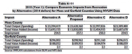
When totaled, the FRMP concludes that 516 jobs are related to recreational usage of GJFO lands and more than $47.5 million in spending flows to the Colorado state economy which represents an increase of estimates to more than 7x original estimates. Despite expansion of recreational spending to 7x, cultural resource management simply did not change in terms of total number of sites to be protected (1,894) or allocation of the sites to usage categories. These usages are summarized as follows:

Use Category Mandatory closure # of sites in Draft # of sites in Final
Scientific 100m 1,574 1,574
Conservation 100m 4 4
Traditional 200m 135 135
Public usage 100m 95 95
Experimental n/a 79 79
Discharge n/a 7 7
TOTAL 1,874 1,874

The failure to balance multiple uses in cultural resource management is directly evidenced by the failure to change any aspect of cultural resource management after the economic contribution of recreation activity has expanded to more than 7x original estimates. No explanation has ever been provided to explain how the ROD determined there is no relationship between recreational access and cultural

resource management closures. Such a position fails to satisfy the Court’s requirement that misleading economic assumptions must not be relied on in the NEPA process.

13. Conclusion.

This statement of reasons involves three questions of law, which are: 1) May the BLM withhold relevant inventory information on the 966 cultural sites found ineligible for listing on the National Register; 2) Does the ROD properly balance of multiple usage of the 1,894 cultural sites identified for management; and 3) Is the economic analysis of the ROD sufficient to justify no change in cultural resource management when recreational economic contributions in the ROD were expanded to 7x original estimates? The Organizations vigorously submit each question must be answered in the negative and each question represents a separate basis to overturn the ROD and return it to the Field Office for resolution of these issues.

Please feel free to contact Scott Jones at 518-281-5810 or via email at scott.jones46@yahoo.com or via USPS mail at 508 Ashford Drive, Longmont, CO 80504 if you should wish to discuss any of the concerns raised further.

Respectfully Submitted,

Scott Jones, Esq
COHVCO/TPA Authorized Representative
CSA President

D.E. Riggle
Director of Operations
Trails Preservation Alliance


1 See, 5 USC §706.

2 See, 36 CFR 800.4(d)

3 See, Thomas King; Cultural Resource Laws and Practice; 4th Ed; 2013 Altamira Press at pg 153.

4 See, Baltimore G& E Co v. NRDC; 462 US 87 (1983) at pg 98.

5 See, Section 1 of the National Historic Preservation Act, Pub. L. No. 89-665, as amended by Pub. L. No. 96-515 generally Title 54 of the United States Code

6 See, 54 USC 300101

7 See, 43 USC §1701

8 See, BLM Manual 8120.1B

9 See, BLM Manual 8100. 06C

10 See, Jennifer Richman et al; Legal Perspectives on Cultural Resources; 2004 Rowan and Littlefield Publishers; at pg 1

11 See, 36 CFR §804c.

12 See, BLM Cultural Resources Manual 8110 at 8110.32E.

13 See, 36 CFR Part 800.4 (b)(1).

14 See, BLM NEPA Handbook 1790-1; January 2008 at pg 73.

15 See, BLM Cultural Resources Inventory Manual- Manual 8110 @ 8110.21a(5).

16 See, BLM Cultural Resources Inventory Manual- Manual 8110 @ 8110.21a

17 See, DOI BLM, Grand Junction Resource Area; Resource Management Plan and Environmental Impact Statement (November 1985) at pg 8.

18 See, California v. Block, 690 F.2d 753, 765 (9th Circ, 1982) ; See also, Trout Unlimited v. Morton, 509 F2d 1276, 1284(9th Circ 1974).

20 See, FRMP page 2-130-

21 See, FRMP pages 2-132

22 See, 40 CFR 1506.6(f) at pg 16.

23 See, FRMP at pgs 2-134 to 2-136

24 See, BLM Instruction Memorandum No 2007-030; Clarification of Cultural Resource Considerations for Off Highway Vehicle (OHV) designation and travel management; Program areas: Cultural resources; Recreation; Planning ; Dated December 15, 2006 A copy of this memorandum is available here http://www.blm.gov/wo/st/en/info/regulations/Instruction_Memos_and_Bulletins/national_instruction/2007/im_2007-030.html .

25 See, BLM memo 2007-030; supra note 32.

26 http://www.nationalregisterofhistoricplaces.com/

27 http://historicrealestate.preservationnation.org/

28 See, BLM Cultural Resources Inventory Manual- Manual 8110 @ 8110.21a

30 Id photographic plate at pgs 56 and 70.

31 See, Rand A. Greubel, Strategies and Methodologies for Investigating Wickiup Sites; Presented at the Colorado Council of Professional Archaeologists Annual Meeting, March 5, 2005, Grand Junction, Colorado; at pg 1.

32 See, Colorado Wickiup Project supra note 158 at pages 64-69.

33 See, Gruebel supra note 39; at pg 2.

34 See, Martin et al; The Colorado Wickiup Project Volume V: Test Excavation of The Ute Hunters’ Camp (5RB563) and the Documentation of Five Additional Aboriginal Wooden Feature Sites in Rio Blanco County, Colorado; September 2010 plate 7

35 Hughes River Watershed Conservancy v. Glickman; (4th Circ 1996) 81 F3d 437 at pg 442; 42 ERC 1594, 26 Envtl. L. Rep 21276.

36 See, Hughes River Supra note 2 at pg 442 .

37 See, Hughes River, Supra note 2 at pg 442.

38 DRMP at pg 2-247

39 See, FRMP at pg 4-478

40 See, FRMP at pg 4-479

pdficon_large.gif GJFO Appeal Final – 01/13/16
pdficon_large.gif COHV Coalition – BLM’s Answer and Motion to Dismiss In Part – 03/21/16
Continue Reading

2016 Colorado 600 Registration

2016 colorado 600

Online registration starts March 1st!

2016 Ride dates: September 11th – 16th

The new website is live! www.colorado600.org

What is it?
The Colorado 600 is a five day ride and trail symposium through the mountains of southwestern Colorado.  Each day the riders will learn about what is facing the trail riding enthusiast and the issues facing our trails in Colorado and Utah.  Riders are able to bring two or three bikes, giving them the option of single track, dual-sport or adventure trails.  You get to choose your ride for the day based on what you are in the mood for.  All proceeds from the ride will go to support the Colorado Trails Preservation Alliance, a Colorado 501c3 non-profit.

Look for another great event in 2016!

Continue Reading